Background
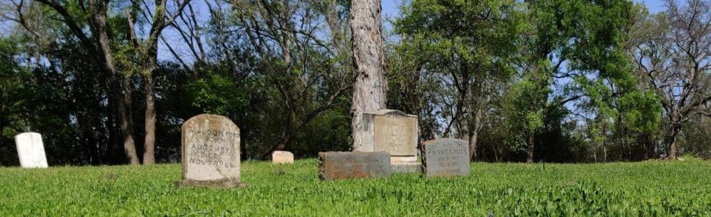
Located at 1150 Springdale Road in City Council District 1, Plummers Cemetery, an 8-acre property, is a historically African American, Upper South folk cemetery, containing family plots, handmade markers, and examples of art and craft. The development of Plummers Cemetery is largely a matter of speculation today, as the records available are limited. It was likely established prior to 1898, the death year of Jack Jones, possibly the first person interred in the cemetery with a marker.
The cemetery may have been known as Mount Calvary Cemetery, not to be confused with another Mount Calvary Cemetery (located elsewhere in the city). The cemetery was named for Thomas P. Plummer (1860–1926), an African American Texas native who owned a farm in Travis County and later worked as the cemetery sexton.
The City of Austin acquired Plummers Cemetery in 1957 as a condition of the purchase of land for Givens Park. Over time, the aging grave markers, many of which were handmade markers, have been lost, leaving the location of many burials unknown.
This project aims to add to a contemporary map created by Save Austin's Cemeteries founder Dale Flatt.
Project Description
The City of Austin is partnering with Texas A&M to conduct research on determining the locations of unknown burials at Plummers Cemetery. Not much is known about Plummers, and even less is known about how many burials we actually have there.
Texas A&M plans to use ground penetrating radar (GPR) to find the perimeters of each grave below the ground surface. GPR uses high frequency radio waves to detect change in the soil. GPR has been used across the country to relocate lost graves and was used during the Oakwood Chapel in the 2017 rehabilitation to determine where the caskets of the deceased were located.
Anticipated Timeline
The surveying of the cemetery using ground penetrating radar will begin in early November 2023. Texas A&M and the Parks and Recreation Department anticipate sharing the results with the public in Spring 2024.
Contact Information
For questions or more information, you can contact Ryan Dees, Environmental Program Coordinator with Cemetery Operations, by phone at (512) 978-2320 or by email at Ryan.Dees@austintexas.gov.