Geomorphic analysis in the engineering and implementation context is used to quantify channel morphological parameters as they relate to design of a stable system. Geomorphic analysis provides:
- Quantitative channel and stability assessment tools
- Foundation for natural channel design
- Prediction of short- and long term channel change
- Optimize design for stability and natural channel processes
- Estimate maintenance requirements
All of these components interact with each other to form the ultimate channel configuration. In urban channels these elements often become “out-of-phase” with each other as the channel adjusts to imposed watershed conditions.
General Channel Stability There are levels of analyzing channel stability and developing solution types. Generally the approach is based on the extents of the affected processes and constraints typically limit the selected solution type. Channel stability can be looked at on a large watershed scale or down to site specific problems.
Approaches to Channel Stability
- Watershed-scale
- Upland Stormwater Management Controls
- (ponds, disconnected impervious cover, impervious cover limits)
- Reach-based
- Channel lengths with common hydraulic/morphologic characteristics
- Site Specific
- Stabilization of isolated stretch of channel (usually for property protection)
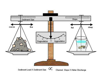
General Channel Adjustment For watershed, stream reach based and site-specific situations, the Stream Restoration Program utilizes the concept that a stream reach equilibrium is dominated by the hydrology, hydraulics and sediment load. A relationship proposed by Lane can be used to qualitatively identify these physical processes dominating the system.
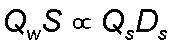
Qw = water discharge S = channel slope Qs = sediment discharge Ds = sediment size
Our experience shows that the most common response to urbanization in degrading reaches can be represented as:
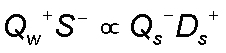
The (+) signs indicate an increase in water discharge (Qw) and coarsening of the channel bed material (Ds); the S- indicates the river slope would decrease through meandering (planform adjustment) and/or downcutting (geometric adjustment) and the relative sediment supply would decrease in an incising reach. This qualitative analysis provides a basis for more quantitative analyses.
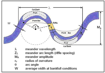
Channel Planform Channel planform is evaluated to assess the condition of stream meanders and the tendency of the channel to migrate laterally. Channel planform characteristics are most readily assessed using historical aerial photography and mapping. The most commonly used geomorphic planform variables are:
- Sinuosity
- Meander Amplitude and Belt Width
- Meander Wave Length
- Meander Arc Length
- Meander Radius of Curvature
- Meander Arc Angle
- Riffle-Pool Spacing
- Channel Width
Channel Sinuosity and Meander Belt
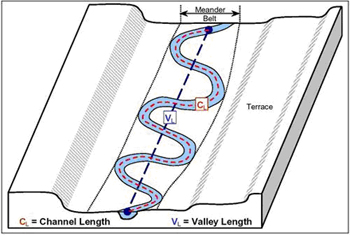
Sinuosity is the ratio of the length of the centerline of the channel (CL) to the length of a line defining the general trend of the valley or stream reach (VL) and describes the amount of meandering in a stream.
Sinuosity = CL / VL
Channel Planform Characteristics
Some commonly used relationships for planform in natural stable systems are as follows:
- 10 to 14W
- Riffle spacing 5 to 7W or ½
- rc 2 to 3W
In general pools are located in bends, riffles are located near crossings. It should be noted that the relations for wavelength and radius of curvature have been most often been identified in stable natural systems and should be used with discretion in the urban environment. This is because impervious watershed conditions accelerate the erosion process and can cause a shift from the natural condition. However these relationships are used as a starting point for many channel reconstruction projects. They can be used to determine whether a system is “out-of-phase” and provide design targets for stabilization projects. From historical observation and common planform relationships the Stream Restoration staff are able to ascertain the probability of bank retreat in a particular area.
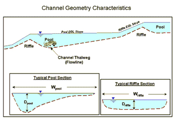
Channel Geometry and Profile Channel geometry refers to the cross sectional and longitudinal parameters that affect the amount of channel conveyance and hydraulic forces on the channel boundary. Some common channel geometry parameters are:
- Channel Width
- Flow Area
- Hydraulic Radius
- Hydraulic Depth
- Depth of Flow (maximum depth)
- Width/Depth Ratio
- Bank Height
- Channel Profile
The channel geometric parameters vary throughout a stream reach depending on location these can be averaged to estimate the "reach-average" conditions for certain types of evaluation and analysis.
Relationships that relate channel geometry to hydrology are termed “regime equations” and are based on observations of a large group of streams. These relationships usually take the form of:
- W = aQb
- d = cQf
- V = kQm
- S = fQz
For width (W), depth (d), velocity (V) and slope (S)
As with planform channel geometric relations are only relevant in stable systems and should be used with discretion in the urban environment. In areas with rapid land-use change such as developing watersheds relationships such as these may be useless for design. However they may be used for comparative purposes. In older or undeveloped watersheds they may prove more functional. In general more detailed analyses are required to determine appropriate stable channel geometry in areas where watershed land use has been altered.
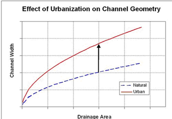
Drainage area is also used as a surrogate to discharge in channel geometry relationships. It has been observed that the trend is and upward shift in the relationship for channel width to drainage area as a result of urbanization.
The channel adjustment process resulting from urbanization can also be expressed with incised channel evolution model proposed by Schumm (1984).
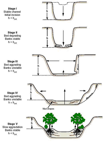
The critical bank height at which mass failure begins is described as hc. when the bank height (h) exceeds hc (Stages II - III) geotechnical failures can be expected.
Observations in Austin indicate that the progression from Stage I to II occurs quite rapidly (10- 30 years) and the widening and restabilization process (Stage IV – V) occurs over a much longer time frame. Most of our urban streams that have been impacted are currently in stages II & III. This identification allows us to utilize other empirical and analytical methods appropriately. The channel evolution model serves to tell us:
- Where the Channel has Been
- Where the Channel is in its Evolution
- Where the Channel is Going
It is important to identify the channel stage of evolution in order to develop appropriate mitigation strategies and reduce future adverse impacts.
Bed Material Characteristics The size, shape, composition and distribution of material in the channel bed are important to the channel stability. These characteristic are used to determine the mobility of the channel bed and subsequently the erosion potential. In general larger sediment sizes (cobbles/boulders) act to stabilize the channel bed, where smaller particles (sand/silt) are more readily erodible. The distribution of particle sizes in bed material mixtures affects the ability of water to mobilize these sediments. The characteristics of the bed material are analyzed through visual observation and gradations developed from sieve analyses or pebble counts.
Bed Material Gradation Curve
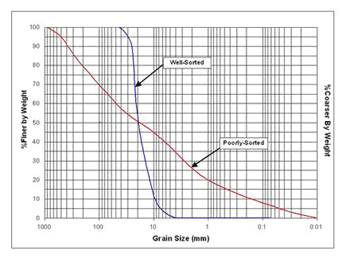
A well-sorted sediment mixture consists of grains that are of uniform size and a poorly-sorted sediment contains particles of many sizes. A poorly-sorted sediment may be indicative of a high energy/flashy system. A poorly-sorted stream may also include large particles that armor the channel bed.
The shape of the bed material affects its stability. Angular particles will provide more stability than rounded particles because of the interlocking and friction characteristics.
The chemical composition of the bed material particles affect how it breaks-down, changes size and shape as the material moves downstream. Weaker materials such as shale and limestone degrade faster than quartz-based sediments.
Bank Composition The type of material and stratigraphy in a channel bank affects its erosion potential. Bank stratigraphy is identified and measured in the field. Geotechnical analyses are performed to analyze the strength characteristics of the bank materials. Many channels in Austin are comprised of composite channel banks with bedrock, clay, alluvium and soils.
Composite Channel Bank in Shoal Creek
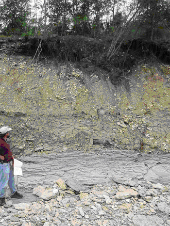
Composite Channel Bank in Onion Creek
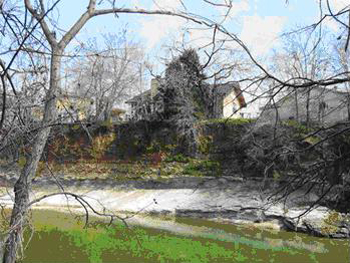
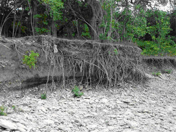
Riparian Vegetation Vegetation acts to provide channel stability as the root systems strengthen the bank material and resist erosive forces. Deep rooted plants and trees give internal strength to the soil mass comprising the channel bank. Shallow rotted plants such as grasses provide more erosion resistance to surficial forces from flowing water. In addition riparian vegetation is an essential component of the aquatic ecosystem.
Roots in the Channel Banks