
Before stormwater runoff reaches a creek, it usually flows through a system of smaller ditches and drainage pipes. Austin has over 1,100 miles of such systems. When the storm drain system is undersized or damaged, there may be flooding of houses, roads, and yards.
We plan, design and construct projects to help reduce local flooding. The projects generally involve installing more and larger storm drain pipes as well as inlets and outfalls. Sometimes detention ponds are also needed to avoid worsening flooding downstream of the new system. Priority is given to the most cost-effective projects that can help the most homes at the most severe risk.
This page summarizes the process of our work and highlights several projects.
Featured Project – Oak Knoll Storm Drain Improvements
This project will improve the storm drain system in part of the Oak Knoll neighborhood. Our contractor started work in November, beginning with water and wastewater lines on Columbia Oaks Drive. The contractor is authorized to work 7 a.m. to 7 p.m. seven days a week.
- Read the December 5, 2025, email update about the Oak Knoll project.
- Sign up for email updates about the Oak Knoll project.
- Go to more information about the Oak Knoll project.
Components of a Storm Drain System
In Austin, most storm drain systems include pipes underneath the road that carry stormwater safety to a creek or lake. Water enters the pipes through curbside inlets, which look like a concrete slab at the edge of the road. Curb and gutter along the road are an important part of this system and help keep water out of yards. Water should drain off the road into the storm drain system in most storms.
Water is released from the storm drain into a creek at the outfall. There may be a wall, small concrete blocks called energy dissipators or stones at the outfall to help prevent erosion. In some cases, water is released into a detention or water quality pond rather than directly into a creek.
Some neighborhoods have roadside ditches instead of underground pipes.
Storm drain systems may be undersized in neighborhoods that were built before drainage regulations took effect in the early 1980s. Annexed neighborhoods may also have inadequate drainage infrastructure.
No Adverse Impact
A new storm drain system can speed up the flow of water and allow it to reach the creek more quickly than before. We must evaluate the potential impact of our projects and take steps to prevent worsening of the floodplain downstream of the project. This may take the form of a detention pond, widening of the channel, or additional drainage easements to give the water more space.
Easements
We sometimes need to purchase easements from private property owners to construct our projects. Easements are a legal right that allows us to use a designated portion of another person’s property for a specific purpose. There are many different types of easements, and the specified purpose can vary. Easements can be temporary or permanent. For our drainage projects, we generally purchase both temporary easements for construction and permanent drainage easements.
Process
Our capital improvement projects take many years from start to finish. The process typically includes the following phases:
- Feasibility Study – when information is collected to identify potential solutions.
- Preliminary Engineering – when a solution is identified and costs are estimated.
- Design and Permitting – when the details are worked out, construction plans drawn up and permits are acquired. Easements, if needed, are usually acquired during this phase as well.
- Bidding – when a contractor is hired.
- Construction – when the project is built.
Construction is dependent upon the availability of funding. In some cases, we are not able to identify a feasible or cost-effective solution during the first two phases.
Report a Drainage Problem
Resources
Project Summaries
- Annie Street Flood Risk Reduction
-
This project will improve the storm drain system in the East Bouldin area between South First Street and Congress Ave. It will help protect the area from localized flooding. The project includes:
- Installing new storm drain pipes
- Upgrading existing storm drain pipes
- Improvements to water and wastewater infrastructure
- Street repairs
- New sidewalks
See a map of the proposed storm drain for the Annie St. project and a map of the proposed water and wastewater improvements.
Watershed
East Bouldin Creek
Location
In the Bouldin Creek Neighborhood between South First St. and Congress Ave. to the east and west; between Annie St. and Live Oak St. to the north and south.
Phasing
Due to the size of the project, it has been divided into two phases for construction. Construction will start with the southern part of the project.
Status
October 13, 2025: We are nearing the end of design for both phases. Construction is anticipated to begin on the first, southern phase in 2027. However, neighbors may notice construction activity before then since Texas Gas Service will be relocating gas lines in advance of this project.
To be added to the email distribution list, please email Stephanie Lott or call 512-974-2799.
Opinion of Probable Construction Cost
- Phase 1: $5.5 million
- Phase 2: $8.1 million
Documents
- Presentation Slides from Public Meeting, September 2024
Preliminary Engineering Report - Preliminary Engineering Report, Appendix A - C
- Preliminary Engineering Report, Appendix D - G
- Preliminary Engineering Report, Appendix H & I
- Preliminary Engineering Report, Appendix J & K
- Preliminary Engineering Report, Appendix L - T
Questions?
Please reach out to one of the following people:
- Madison Moss, Project Sponsor, 512-952-1566 or email Madison.
- Mel Fuechec, Project Manager, 512-974-5635 or email Mel.
- Boggy Creek & MLK Storm Drain Improvements
-
This project consists of upgrading the storm drain system near Martin Luther King Jr. Blvd. and the railroad tracks near the CapMetro Red Line crossing. During heavy rain, there is potential for this area of MLK Blvd. to become impassable.
During the original construction of the Red Line, portions of the needed storm drain system were constructed. They were not placed in service until the rest of the system could be built. This project includes the rest of the system as well as a crosswalk with a pedestrian hybrid beacon, new sidewalk and other miscellaneous improvements.
Watershed
Boggy Creek
Location
In the area near MLK Jr. Blvd. and Manor Road and the railroad tracks for the CapMetro Red Line.
Phasing
This project has been split into three phases. Phase 1 and 2 have been completed.
Status
Phase 3 reached the 90-percent design milestone on April 18, 2025.
Opinion of Probable Construction Cost
$7.1 million
Documents
Questions?
Please reach out to one of the following people:
- Laurie Thering, Project Manager, Capital Delivery Services, 512-974-7035 or email Laurie
- Glen Taffinder, Engineer, Watershed Protection, 512-974-3381 or email Glen
- Brentwood Neighborhood Integrated Drainage Improvements
-
This study is evaluating potential solutions for flooding, erosion and water quality problems along three tributaries of Shoal Creek. This area lacks adequate drainage infrastructure because it was developed before current drainage regulations went into effect. Homes are built within the floodplain, the storm drain pipes are undersized and erosion threatens streets, utilities, and houses. There are three recommended projects coming out of the study:
- Lower Grover Channel area – project would include a diversion system for the Grover Channel, streambank stabilization along the Grover Channel, stormwater detention systems at McCallum High School near the tennis courts. Construction for this project is estimated to cost $17.9 million and benefit 24 homes. See map of Recommended Project 1 in the lower Grover Tributary area.
- Upper Grover Channel area – project would include storm drain improvements on and near Grover Ave. and a detention pond that could function as a dual use soccer facility. Construction for this project is estimated to cost $13.6 million and benefit 23 homes. Construction of this project is dependent on the construction of Lower Grover Channel as Phase 1. See map of Recommended Project 2 in the upper Grover Tributary area
- Hancock Branch area – project would include underground detention storage along Hancock Channel, storm drain improvements and diversion systems for the Goodnight Tributary, and storm drain improvements in the Madison area. Construction is estimated to cost $33.7 million and benefit 19 homes. See map of Recommended Project 3 in the Hancock Branch area
We have tried to find ways to help reduce flood risk for as many homes as possible, but the projects would not benefit all homes that are currently at risk of flooding. Cumulatively, these projects would benefit 59 homes by reducing the frequency and depth of flooding. Looking at a 100-year storm, which has a one percent chance of occurring in any given year, there are 70 homes at risk of flooding in the project areas. For more information about current flood risk, please see the Existing Conditions Map.
Please note that the proposed stormwater detention systems in the lower and upper Grover Channel areas are contingent upon future negotiations with property owners.
Watershed
Shoal Creek
Location
The study area includes parts of the Brentwood and Crestview neighborhoods. The study area is generally between Burnet Road and North Lamar Ave., starting at Morrow St. to the north and extending south of Koenig Lane. It includes parts of three small creeks that eventually join with Shoal Creek:
- Hancock Tributary
- Grover Tributary
- Goodnight Tributary (flows into the Hancock Tributary)
Phasing
These projects can be constructed in phases as funding is available.
Status
Preliminary Engineering. Please note that we have not identified funding to move into design or construction phases.
To sign up for email updates, please email Stephanie Lott or call 512-974-2799
Opinion of Probable Construction Cost
$65.2 million
Documents
- Executive Summary of Preliminary Engineering Report (July 31, 2025)
- Presentation from April 2025 meetings.
- Recording of presentation at the Brentwood Neighborhood Association Meeting (April 2, 2025).
Questions?
Please reach out to one of the following people:
- Dario Octaviano, Project Manager, 512-974-7607 or email Dario
- Pamela Ruiz, P.E., Project Sponsor, 512-974-6313 or email Pamela
- Danielle Guevara, Project Sponsor, 512-974-3011 or email Danielle
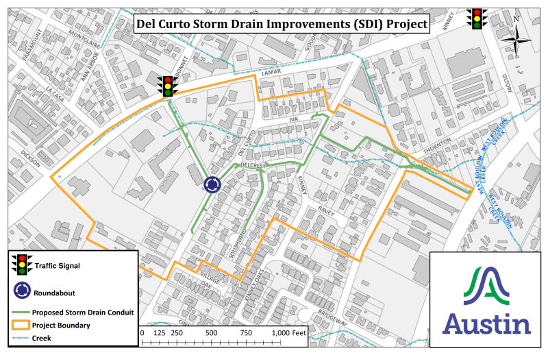
- Del Curto Flood Risk Reduction
-
This project will improve the storm drain system in the South Lamar area and help protect the area from flooding. The existing Del Curto storm drain system straddles South Lamar Boulevard. It consists of 9,300 feet of pipe, a section of open channel and 38 inlets. The system is not large enough to drain the amount of stormwater that it needs to. There are at least 20 buildings, yards and streets at risk of flooding. This project includes:
- Installing new storm drain pipes or upgrading existing ones on Bluebonnet Lane, Del Curto Road, Delcrest Drive, Iva Lane, Kinney Road, Southland Drive and across properties between Kinney Road and West Bouldin Creek.
- Adding curb and gutter along part of Bluebonnet Lane.
- Installing a new roundabout at the Del Curto Road and Bluebonnet Lane intersection.
- Building a shared-use path for pedestrians and cyclists on Bluebonnet Lane, between South Lamar Blvd. and Del Curto Road.
View a map of the proposed project or get more information about the South Lamar Boulevard Mobility Program.
Public Meeting
Thank you to all who joined the virtual public meeting to learn more about the project, hear construction details, and meet the contractor. Below are links to the presentation and recording of the meeting in case you were unable to attend.
Watershed
West Bouldin Creek
Location
This project is entirely on the southeast side of S. Lamar Blvd. near Bluebonnet Lane, Del Curto Road and Thornton Road.
Easements
We have acquired a number of easements, some to provide space for water to flow, some to allow us to install, access, and maintain pipes and other infrastructure.
Status
The Austin City Council approved the construction contract in late September. Construction started in November 2025.
Construction Cost
$9.7 million
Documents
Questions?
- Abhi Raghavan, Project Manager, 512-974-7810 or email Abhi.
- Heather Peart, Project Sponsor, 737-393-6106 or email Heather.
- Jennifer Newell, Project Manager (for the roundabout), 512-974-2862 or email Jennifer.
- Oscar Ramirez, Construction Inspector, 512-948-6098 or email Oscar.
- Glenn Lane/Slayton Drive Storm Drain Improvements
-
This project will replace a failing storm drain pipe to help reduce the risk of flooding. The existing pipe runs through backyards, making it difficult to access and maintain. The new pipe will be relocated to the right-of-way. This will reduce flood risk by allowing our crews easier access for future maintenance. View map of proposed project.
Watershed
Little Walnut Creek
Location
This project is in the Georgian Acres neighborhood in the area generally bounded by Glenn Lane, Carpenter Avenue, and Slayton Drive.
Status
The Austin City Council approved the construction contract in late July 2025. Construction is anticipated to start in the fall of 2025.
Construction Cost
$1.4 million
Documents
- View PDF copy of the presentation (September 10, 2025)
Questions?
Please reach out to one of the following people:
- Cristina Acuňa, Project Manager, 512-974-3067 or email Cristina
- Kristina McLaren, P.E, Project Sponsor, 512-974-4320 or email Kristina
- Michael Castro, Project Inspector, 512-974-3734 or email Michael
- Guadalupe St. Flood Risk Reduction
-
This project will improve the storm drain system in parts of the Hyde Park and North University neighborhoods and reduce the risk of flooding. We suspect that an entire creek or small tributary was diverted into the storm drain system when the neighborhoods were developed. Roads and possibly structures were built where the water once flowed.
The proposed project includes:
- Upgrading 20,000 feet of storm drain pipes
- Optimizing the outfall of the Triangle Pond and its two main headwalls
- Adding debris blockers at the Triangle Pond outfall
- Relocating underground utilities as needed.
- Improvements to water and wastewater lines.
- Streambank stabilization along Hemphill Branch within the park.
To prevent worsening flooding along Hemphill Branch, the proposal also includes the following:
- Adding a detention pond in the field next to the Baker Center
- Adding underground detention
- Adding two detention basins in the grassy areas of Adams-Hemphill Neighborhood Park and developing a park concept plan. More information about concept planning for the park.
View project map. Note that north is located on the left side rather than the top on this map.
Flood Risk
We estimate 224 buildings are at risk of flooding in a 25-year storm. A 25-year storm in this area is 9 inches of rain in 24 hours and has a 4% chance of occurring. With this project in place, computer modeling shows that 178 of those buildings would no longer flood with that much rain.
Watershed
Waller Creek
Location
General project boundaries are Avenue D, W. 33rd St., Guadalupe St. and W. 47th St., as well as Adams-Hemphill Neighborhood Park.
Phasing
Due to the increasing complexity and cost of the project, we are considering dividing construction into multiple phases. For the general sequence of work, see the implementation plan.
Easements
This project includes acquiring easements along an existing pipe as well as drainage easements within Adams-Hemphill Neighborhood Park.
Status
The project is currently in the design phase. We do not anticipate allocating funding for construction of Phase 1 sooner than 2028, although we will continue to look for grant funding.
Email Stephanie Lott to receive email updates about the project or call 512-974-2799.
Opinion of Probable Construction Cost
More than $100 million
Documents
- 33rd Street bridge renderings
- Proposed concept plan for Adams-Hemphill Neighborhood Park
- Plan profile for Adams-Hemphill Neighborhood Park
Questions?
Please reach out to one of the following people:
- Kristina McLaren, P.E., 512-974-4320 or email Kristina.
- Dario Octaviano, Project Manager, 512-974-7607 or email Dario
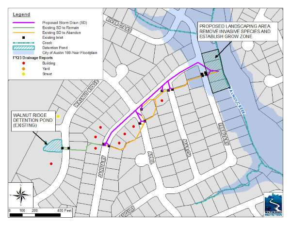
- January Dr. Flood Risk Reduction
-
This project will upgrade the storm drain system on January Drive to help reduce the risk of flooding. The current storm drain pipe is undersized and located on private property. The pipe crosses through yards, between houses and under sheds and fences. This makes it difficult to access and maintain.
This project includes decommissioning most of the current pipe and installing a new, larger one underneath January Drive. This new pipe would have more capacity and also be within the public right of way for easier maintenance. The inlets are currently located on January Drive and would remain the same.
The project also includes work on the outfall along Walnut Creek in the buyout area on February Dr. There is a spring at this location, and we will be taking measures to protect it during construction.
There is also erosion along the banks of Walnut Creek in this area. We plan to establish a “Grow Zone” to restore native trees, shrubs, grasses and wildflowers and help prevent further erosion. There is no mowing within a Grow Zone to help native vegetation become established over time. The project also includes some native plantings.
We are in the process of transferring the buyout area along February Drive to the City of Austin’s Parks and Recreation Department.
Flood Risk
Please note that the new, larger storm drain pipe will help reduce flood risk for several homes. However, we cannot make the pipe large enough to meet current City of Austin standards. This is not unusual when retrofitting an older storm drain system. We are constrained by lack of space underneath the street due to the presence of other utility lines and by the limited capacity of the creek. City of Austin standards call for stormwater to be contained within the street during a 100-year storm or 13 inches of rain in 24 hours.
We have previously bought and removed several houses along Walnut Creek on February Dr. to reduce flood risk. We have also removed sediment and vegetation from the detention pond on Walnut Ridge Drive, which will also help.
Watershed
Walnut Creek
Location
The project area includes January Drive, roughly between August Dr. and February Drive. It also includes the green space on February Drive where there used to be houses.
Status
Construction began in May 2025 and could take about a year to complete.
Construction Cost
$2.1 million
Documents
- Presentation from April 16, 2025 (Note: the contact information on Slide 15 has been updated since the meeting.)
- Watch a recording of the April 16, 2025, meeting.
Questions?
Please reach out to one of the following people:
- Isaac Chavez, P.E., Project Sponsor, 512-974-2349 or email Isaac.
- Darryl Haba, Project Manager, 512-974-2777 or 512-293-8052, or email to Darryl.
- Antonio Lopez, Construction Inspector, 512-247-8741
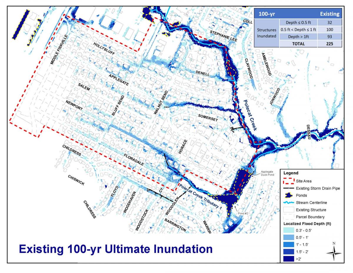
- North Acres Storm Drain Improvements
-
This project will help protect the North Acres neighborhood from flooding. The neighborhood’s storm drain system is very limited. Stormwater is conveyed to the creek mostly through the streets. However, due to the way the neighborhood slopes, a lot of stormwater also flows from yard to yard. The water may pass through several yards before it reaches a street. Our project will help reduce flooding that is coming from the streets.
This project includes:
- Installation of storm drain pipes, inlets and outfalls.
- Restoration of the pavement, including curb and gutter
- Austin Water's Newport Ave. Pipeline Renewal project
Ponds
There are three ponds in the North Acres neighborhood. These ponds are on privately-owned land and were not built for drainage purposes. The project will not include improvements to these ponds. Two of the ponds typically hold water. You may not be familiar with the third pond because it looks like part of the creek bed. It does hold some floodwaters, but is too small to provide significant flood benefit. Please also note that the City of Austin does not have the responsibility for the maintenance of these ponds. Resources for pond owners can be found on our Permits and Inspections web page.
Springs
Residents have told us about the presence of springs in the area. We identified multiple springs near Denell Circle and adjusted the proposed storm drain system to protect them.
Watershed
Walnut Creek
Location
This project is within the North Acres neighborhood, generally between Bluff Bend Drive, Floradale Drive and Polecat Creek.
Phasing
This project was divided into two phases. Phase 1 included restoring the street gutters where feasible and has been completed. Phase 2 will include installing underground storm drain pipes.
Status
Phase 2 is currently in the design phase. We anticipate receiving a permit toward the end of 2026. Construction is dependent upon the availability of funding.
Email Stephanie Lott to receive occasional email updates about this project.
Opinion of Probable Construction Cost
$17 million
Documents
Questions?
Please reach out to one of the following people:
- Hanh Thai, P.E., 512-974-9232 or email Hanh.
- Kirby Haywood, P.E., Project Manager, 512-974-7030 or email Kirby
- Oak Knoll Flood Risk Reduction
-
This project will improve the storm drain system in part of the Oak Knoll neighborhood. This area currently has a very limited drainage system, which is the main reason for flooding in the area. The project consists of installing new storm drain pipes and inlets and improving existing pipes in the following areas:
- Broad Oaks Dr.
- Oak Knoll Dr.
- Woodcrest Dr.
- Columbia Oaks Dr. (project includes three side by side pipes)
- Between backyards of houses on Three Oaks Trail and Columbia Oaks Dr.
It also includes improvements to a detention pond on Chelsea Moor near Broad Oaks Drive. We will increase the pond’s capacity by deepening it. We will connect the pond directly to the storm drain system. View a map of the project.
Watershed
Walnut Creek
Location
The project is located between Woodcrest Drive and Jollyville Road and between Broad Oaks Drive and Columbia Oaks Drive.
Status
December 5, 2025: Our contractor started work in November. You’ll see paint on the streets indicating the location of utility lines, screens placed in front of storm drain inlets, safety fencing in various locations and planks installed around tree trunks. After this preparatory work, the contractor intends to start moving water and wastewater lines on Columbia Oaks Drive.
The Austin City Council authorized the construction contract on Feb. 15, 2024.
- Read the December 5, 2025, email update about the Oak Knoll project.
- Sign up for email updates about the Oak Knoll project.
What to Expect During Construction
Construction can be stressful to people, trees and wildlife. We will do everything we can to help. Please reach out to the construction inspector with any concerns. You can find his contact information below.
The contractor is authorized to work from 7 a.m. to 7 p.m. seven days a week.
Please expect the following:
- Noise, dust, and vibrations
- Detours, lane closures and no parking areas
- Limited tree trimming, if branches are hanging low over the street
- Tree protection, erosion control measures and temporary fences.
- Trenches to install concrete box culverts below the roadway for the new storm drain system.
- Digging behind the curb in some spots to install inlets.
- Workers and equipment in the public utility easement behind houses.
Here is more information about some other impacts:
Water and Utilities
We will need to shut off water periodically to complete some of the work for this project. We will leave a notice 48 hours in advance with two exceptions:
- We may briefly turn off water without notice to test valves and equipment ahead of a planned outage.
- There is always the possibility of a temporary, loss of water or other service if a pipe or line is broken. We’ll respond immediately to restore service if this happens. We have done a lot of research ahead of time to pinpoint where all the underground utilities are. This should help us avoid breaking any pipes.
Get more information about leaks and water outages.
Staging Areas
We will be storing equipment and materials within the project area, also called the limits of construction. Fencing will be installed to identify the limits of construction.
Home Access
You may not be able to access your driveway for a few days when work is directly in front of your house. Please park cars on a nearby street when your driveway is not accessible.
Trees
Trees are important to us, but we will need to remove some to complete this project. We will be taking steps to protect other trees with fencing or planking. We may trim low-hanging branches.
Here’s what you need to do
For the most part, please go about your normal activities as usual. Leave a little extra time when traveling, slow down around our workers and don’t park in temporary “No Parking” areas.
Your safety is important to us! Please stay out of fenced-off areas and keep children and pets away from construction and equipment. If you’re on foot or on your bike, please follow the detours as well.
Opinion of Probable Construction Cost
$9 million
Documents
- Presentation from April 3, 2024, meeting
- Recording of April 3, 2024, meeting
- Technical Memo: Mitigation Alternatives Evaluation, Sept. 2019 (Changes to the Preliminary Engineering Design)
- Preliminary Engineering Report, January 2018
- Technical Memo: 2D Modeling Results, October 2017
Questions?
Please reach out to one of the following people:
- Elmer Reyes, Construction Inspector, at 512-689-0853 or email Elmer.
- Hanh Thai, Project Sponsor, at 512-974-9232 or email Hanh.
- Timmie Bui, Project Manager, at 512-974-7199 or email Timmie.
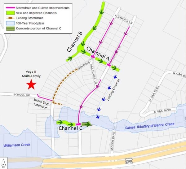
- Oak Park Flood Risk Reduction
-
This project will reduce the risk of flooding in the Oak Park subdivision. A combination of solutions is needed. The project includes:
- Updating two existing channels to handle more water and have a natural look where possible.
- A new offsite channel directing water from the west into one of the updated channels.
- Enlarging culverts on Parkwood Dr. and Oakclaire Dr.
- Installing a new storm drain system along Parkwood Dr. and Oakclaire Dr.
Watershed
Gaines Tributary of Barton Creek. The area sometimes also receives flow from Williamson Creek.
Location
The project is in Oak Hill in the area by Parkwood and Oakclaire Drives.
Status
This project is currently in the design and permitting phase. Construction for Oak Park is contingent upon upgrading the bridge over Oak Blvd., permitting, easement acquisition and availability of funding. The bridge upgrade is part of the Oak Acres Flood Risk Reduction project.
To receive email updates, please send an email to Joan Esquivel. Read the Nov. 2024 project update.
Opinion of Probable Construction Cost
$9.9 million
Documents
- Public Meeting Presentation (PDF), September 2024
- Recording of Meeting, September 2024
- 30% Design Plan Set, pages 1-73
- 30% Design Plan Set, pages 74-145
- Drainage Design and Preliminary Engineering Report, 2023
- Gaines Tributary Watershed Study
Questions?
Please reach out to one of the following people:
- Sharon Teague, Project Sponsor, at 512-974-6343, or email Sharon
- Dario Octaviano, Project Manager, at 512-974-7607 or email Dario
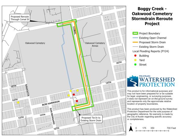
- Oakwood Cemetery Storm Drain Reroute
-
The historic Oakwood Cemetery has experienced severe erosion issues along the existing concrete channel. The channel is undersized, and erosion along it poses a risk to burial sites. This project will redirect stormwater away from the channel to a proposed storm drain system along Comal St. The new storm drain will connect to the existing storm drain system at 13th and Angelina Streets. In addition to reducing the amount of stormwater flowing through the cemetery channel, there will be some reduction in flood risk to residences immediately south of the cemetery.
Watershed
Boggy Creek
Location
Within the Oakwood Cemetery and along Comal St. between 13th St. and Martin Luther King Jr. Blvd.
Status
Preliminary engineering was completed in the fall of 2023. This project is currently in design with construction estimated to begin in early 2027 if funding is available.
To receive email updates, please send an email to Joan Esquivel.
Opinion of Probable Construction Cost
$4.6 million
Questions?
Please reach out to one of the following people:
- Sharon Teague, P.E., 512-974-6343, or email Sharon
- Robert Hermosillo, P.E., 512-974-5634, or email Robert
- Vassal Drive Flood Risk Reduction
-
In this area, most stormwater is conveyed by storm drains, ditches/channels, and streets to the Comburg detention pond. Phase 1 includes:
- Expansion of the Comburg detention pond to increase its capacity,
- Relocation of the channel on the northeast side of the pond from the middle to the back of private property. This provides residents with increased access to their property and allows for increased channel capacity. A new storm drain will be installed to connect Comburg Drive to the channel.
- Installation of a section of storm drain on Comburg Drive.
- Relocation of a wastewater line on Sedgemoor to allow enough space for drainage and wastewater infrastructure.
Watershed
Slaughter Creek
Location
The project includes the area generally bounded by Barkwood Drive to the south, Comburg Drive to the east, Rustic Oak Lane to the north, and Wagtail Cove to the west.
Phasing
The project will be designed and constructed in smaller phases. Each phase will be designed and constructed as separate projects.
Status
Phase 1 is currently in design and is expected to last two years. Construction is anticipated to begin in 2027.
To be added to the email distribution list, please email WPDPIO.
Documents
- Recording of Virtual Meeting (video), August 2023
- Public Meeting Presentation (PDF), August 2023
Questions?
Please reach out to one of the following people:
- Kristina McLaren, P.E., 512-974-4320 or email Kristina
- Dario Octaviano, Project Manager, at 512-974-7607 or email Dario
- Warren St. Flood Risk Reduction
-
The project will improve the drainage system and reduce the risk of flooding for buildings, yards, and streets. Austin Water is partnering on the project to improve or replace water and wastewater lines in the area.
Watershed
Taylor Slough South
Location
Includes part of the Tarrytown neighborhood in the area along Exposition Blvd., Warren St., Carlton Road, Mountain Laurel Lane and Hillview Road.
Phasing
The project will be designed and constructed in phases.
Status
Design for Phase 1 began in summer 2025. Construction is pending funding availability. The schedule is dependent on current, known conditions and funding availability. Read August 1, 2025, update.
Documents
- Presentation from the March 12, 2025, public meeting
- Recording of the March 12, 2025, public meeting
Questions?
- Kristina McLaren, P.E., Project Sponsor, 512-974-4320, or email Kristina
- Claudia Corsetti, P.E., Project Manager, 512-974-7205, or email Claudia
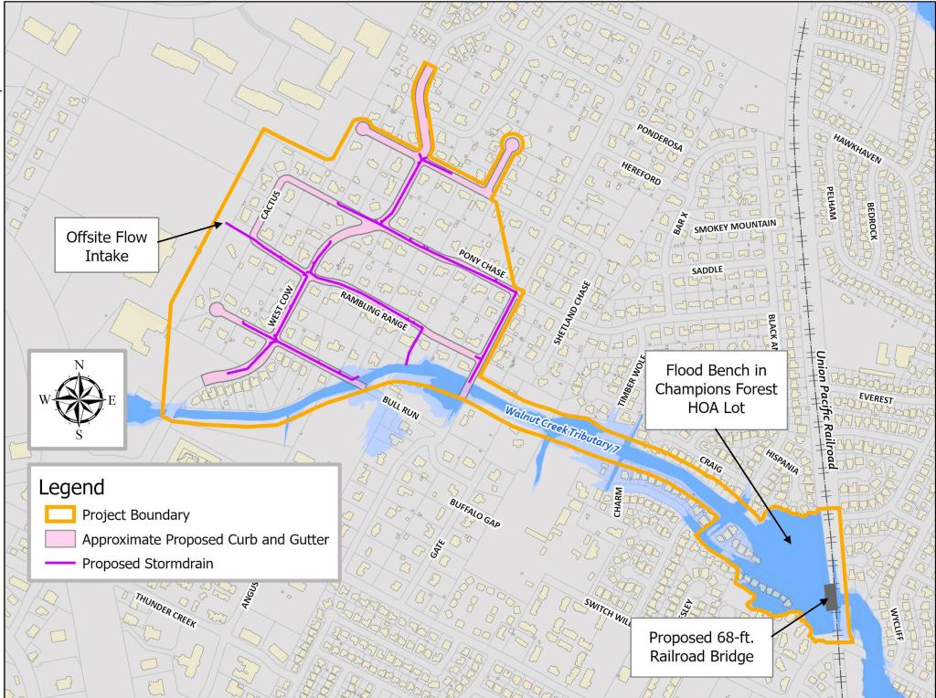
- West Cow Path/Whispering Valley Flood Risk Reduction
-
Several houses along Whispering Valley Road have been flooded repeatedly by a tributary to Walnut Creek in recent years. The railroad crossing over the creek was an 8 foot by 7 foot culvert and did not provide adequate conveyance of water during large storms. This caused water to back up behind the crossing. The railroad crossing has now been upgraded, which should significantly reduce flood risk for these homes.
In the nearby West Cow Path area, the flooding is not coming from the creek, but is due to the lack of storm drain infrastructure. The neighborhood was built in the 1970s, before the City required subdivisions to have underground pipes or ditches to help the streets drain and prevent flooding.
The preliminary engineering study recommends a complex project that includes the following:
- Detaining and temporarily storing floodwaters in the open space owned by the Champion Forest Homeowners Association. This is near Whispering Valley Drive and the railroad crossing.
- Installing curb and gutter in the area near West Cow Path, Bull Run and Branding Chase Street.
- Installing storm drain infrastructure (pipes, inlets, outfall, etc.) in the same area as the curb and gutter.
In addition, we recommended that Union Pacific upgrade the railroad crossing over the creek. View a map of the project.
Watershed
Walnut Creek
Location
This project is partially in the Angus Valley Neighborhood in northwest Austin. It is west of the railroad tracks, near Whispering Valley Road as well as West Cow Path, Bull Run and Branding Chase.
Phasing
This is technically two projects: the flood storage for Whispering Valley and the drainage improvements in the West Cow Path area. The flood storage would be considered a first phase.
Easements
This project requires easements.
Status
- Union Pacific has finished upgrading the railroad crossing.
- The flood storage part of the project is in design. The West Cow Path portion of the project is on hold until further progress is made on the flood storage.
- To be added to the email distribution list for this project, please email Stephanie Lott or call 512-974-2799.
Documents
Questions
Please contact Sharon Teague, 512-974-6343, or email Sharon
Don’t see your project? It may be considered a creek flooding, erosion or water quality-related project. A complete list of Capital Improvement Program projects is available on Capital Project Explorer.
- See list of Watershed Protection projects with web pages
- Go to Capital Project Explorer
- Explore map of projects by Council District
Projects on Hold
Please note that the following projects have been put on hold indefinitely due to lack of funding, lack of community support or other issues:
- Briar Hill Storm Drain Improvements
- Burrell Drive Flood Risk Reduction
- Corona/Broadmoor Flood Risk Reduction