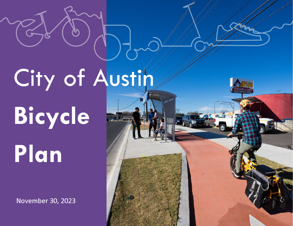
To implement elements of the Imagine Austin Comprehensive Plan, the 2023 Bicycle Plan's goals are to significantly increase bicycle use and improve safety for people riding bicycles throughout Austin. To achieve these goals, an All Ages and Abilities Network is being built out to provide additional transportation options for Austin residents and visitors. Austin City Council voted November 30, 2023, to adopt the Bicycle Plan along with the Urban Trails Plan, and Sidewalks, Crossings, and Shared Streets Plan.
Download Bicycle Plan
Table of Contents
- Executive Summary
- Chapter 1: Introduction
- Chapter 2: Bicycle System
- Chapter 3: Programs
- Chapter 4: Implementation
- Chapter 5: Measuring Success
- Appendices
EXECUTIVE SUMMARY
The 2023 Austin Bicycle Plan (the Plan) reflects today’s best practices in municipal planning for bicycle- like mobility tools (including tricycles, scooters, and other micromobility devices) at a national and international level. The Plan is an update of the 2014 Bicycle Plan and reflects the latest innovation in approaches. The Plan’s comprehensive approaches work to make Austin a more equitable, affordable, multimodal, safer, healthier, and environmentally sustainable City.
CHANGES SINCE THE 2014 PLAN
Much has changed since the adoption of the 2014 Bicycle Plan.
Shortly after its adoption, Austin City Council transitioned from the long-standing at-large system to a single-member district system to fundamentally address long-standing inequities in representation.
The vision for an All Ages and Abilities Bicycle Network of the 2014 Plan was broadly accepted. It became an integral part of the City’s first truly multimodal mobility infrastructure bonds of 2016, 2018, and 2020. These Mobility Bond Referendums gave rise well-funded programs that are planning and prioritization-driven, flexible, dynamic, partnering, transparent, and accountable. The 2020 Referendum also included the ambitious investment in the first phase of Project Connect, the City’s high-capacity transit program.
The COVID-19 pandemic and nation-wide racial reconning of 2020 were also deeply influential just as this planning process kicked off.
While much progress is being made in terms of implementation of the All Ages and Abilities Bicycle Network and attitudes about multimodal transportation use have shifted in significant support, long-standing inequities and continued affordability and displacement pressures frame the challenges ahead.
THE ATX WALK BIKE ROLL PROCESS
ATX Walk Bike Roll was a coordinated effort by the City of Austin’s Transportation and Public Works Department to update Austin’s Sidewalk, Urban Trails, and Bicycle Plans. ATX Walk Bike Roll centered racial equity throughout the plan update process. More information on the ATX Walk Bike Roll planning process can be found in Chapter 1.
VISION
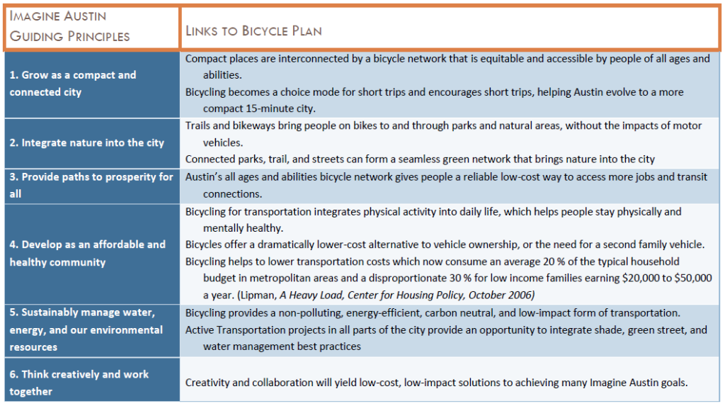
The 2014 Bicycle Plan shifted the focus to what bicycling can do to support reaching the highest goals of the City contained in the Imagine Austin Comprehensive Plan.
The 2023 Bicycle Plan further builds on the 2014 vision and brings a stronger focus on equity.
All Austinites have convenient, practical, and safe choices to take trips by bicycle, tricycle, scooter, or other micromobility devices for all trip purposes. The bicycle network provides equitable access for people of all ages and abilities to local and city-wide destinations, and to connect with nature. Bicycling as a tool is used to provide mobility options and benefits for individuals and help support and realize the City’s highest-level goals for the whole community within the Imagine Austin Comprehensive Plan and other plans and policy goals for our shared equitable and sustainable future.
THREE CENTRAL CHALLENGES
With the 2023 Bicycle Plan centered on equity and grounded through an acknowledgement of the effects of ongoing systemic racism, three central challenges for this Plan update emerged:
- The first challenge is continuing to reshape our city’s built environment, so people have safe streets and trails that provide mobility choices.
- The second challenge addresses the affordability and displacement crisis, which, if not addressed, will make it impossible to provide equitable access to mobility choices.
- The third challenge is changing attitudes and systems of thought to build empathy, understanding, and respect for all.
More information on the three central challenges can be found in Chapter 1.
CONTINUED BEST PRACTICES
The significant shifts in the 2014 Bicycle Plan were to focus on designing for all ages and abilities, catching quick trips, and building a complete network. More information on these continued best practices can be found in Chapter 1.
NEW FOCUS AREAS
The 2023 Bicycle Plan includes several new focus areas. Many of these serve to work towards solutions to more significant and complex issues around equity, planning for a rapidly changing Austin, addressing intersectional issues, and evolving tools for mobility, including:
- Managing affordability and displacement
- Integrated land, affordability, mobility planning for holistic outcomes
- Improving quality of protected bicycle lanes and intersections
- Equitable prioritization of the All Ages and Abilities Bicycle Priority Network
- Climate, climate resiliency, shade, greening streets, and water management
- Physical and mental health
- MetroBike – Austin’s public bike share system
- Electric Bikes, scooters, micromobility devices, autonomous vehicles, and mobility services
- Better social support services
More information on these new focus areas can be found in Chapter 1.
THE PLANNING FRAMEWORK
Building on this Plan’s vision, the 2023 Bicycle Plan continues to support and better integrate with the broader policy framework, and goals and strategies in numerous city-wide plans, including the Imagine Austin Comprehensive Plan, the Austin Strategic Mobility Plan, and others. More information can be found in Chapter 1.
THE ALL AGES AND ABILITIES BICYCLE PRIORITY NETWORK
Like the 2014 Plan, the top infrastructure recommendation is to build a complete All Ages and Abilities (AAA) Bicycle Priority Network to give people safe mobility choices to bicycle, tricycle, scooter, and even use other personal mobility devices.
Additional information on the network can be found on bicycle network best practices, on and off-street components of the network, three new prioritization themes (access to neighborhood destinations, nature, and city-wide destinations) in Chapter 2.
THE EXPANDED AAA BICYCLE PRIORITY NETWORK
The plan includes an expanded network comprised of a set of potential project recommendations on streets developed to deliver the highest cost/benefit on the investment and achieve equitable outcomes.
New network additions were made in response to network analysis, opportunities to connect to Project Connect transit investments, corridor improvements, and input thought this plan process.
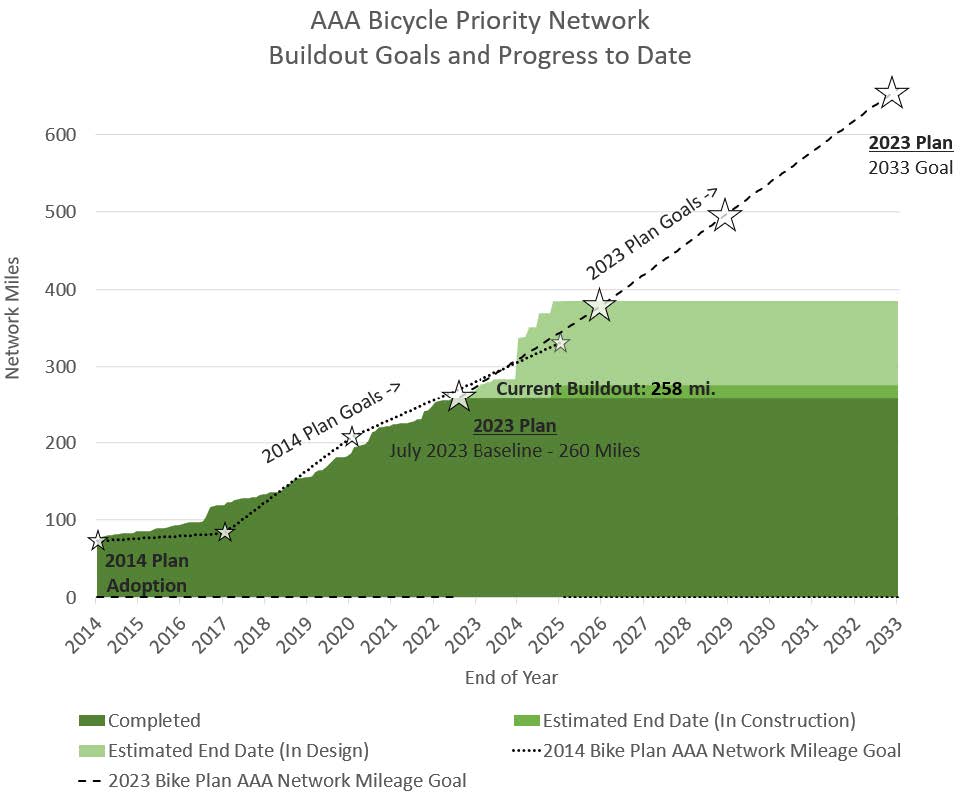
The AAA Bicycle Priority Network updated through this planning effort has grown to over 1,200 miles of protected bicycle lanes, neighborhood bikeways and shared use paths, plus over 300 miles of Urban Trails (existing + priority tiers 1-3). Approximately 250 miles of the network are complete, and 150 miles are already planned and funded for construction by multiple jurisdictions.
Excluding the Urban Trails Network and portions funded by other entities, the cost of the approximately 800 miles of remaining unfunded network has a planning level cost of $1.15 billion. This planning level cost estimate assumes high quality levels of buildout as seen on recent projects like Teri Lane and Shoal Creek Boulevard. This estimate does not include projects funded by other jurisdictions like TxDOT and CTRMA as part of larger regional projects, private developers, or other entities. More information on the Cost of the AAA Bicycle Priority Network can be found in Chapter 2.
The AAA Bicycle Priority Network Online Tool has interactive maps that shows new additions made through this planning process, progress towards buildout goals, and real-time project statuses. More information is included on the AAA Network in Chapter 2.
PLANNING FOR FULL BUILD QUALITY
There was significant community feedback through the ATXWBR planning process to increase the quality of bike lane physical protection.
The plan recommends continued use of phased approaches to balance quickly building out the AAA Bicycle Network using initial quick build approaches and achieving full-build quality of the network over time including concrete or planted bicycle lane barriers, protected intersections, high-quality bus stops, green street infrastructure, adding shade, and addressing lighting.
To increase quality of the network this plan sets full-build quality goals of 5 miles of concrete protected bicycle lanes, 5 protected intersections, and 10 high quality bus stops plus a goal of 5 miles of medium-build protected bicycle lanes with an additional estimated annual cost $14 million per year. The AAA Bicycle Priority Network Online Tool highlights portions of the network that are at full build quality.

PROJECT PRIORITIZATION
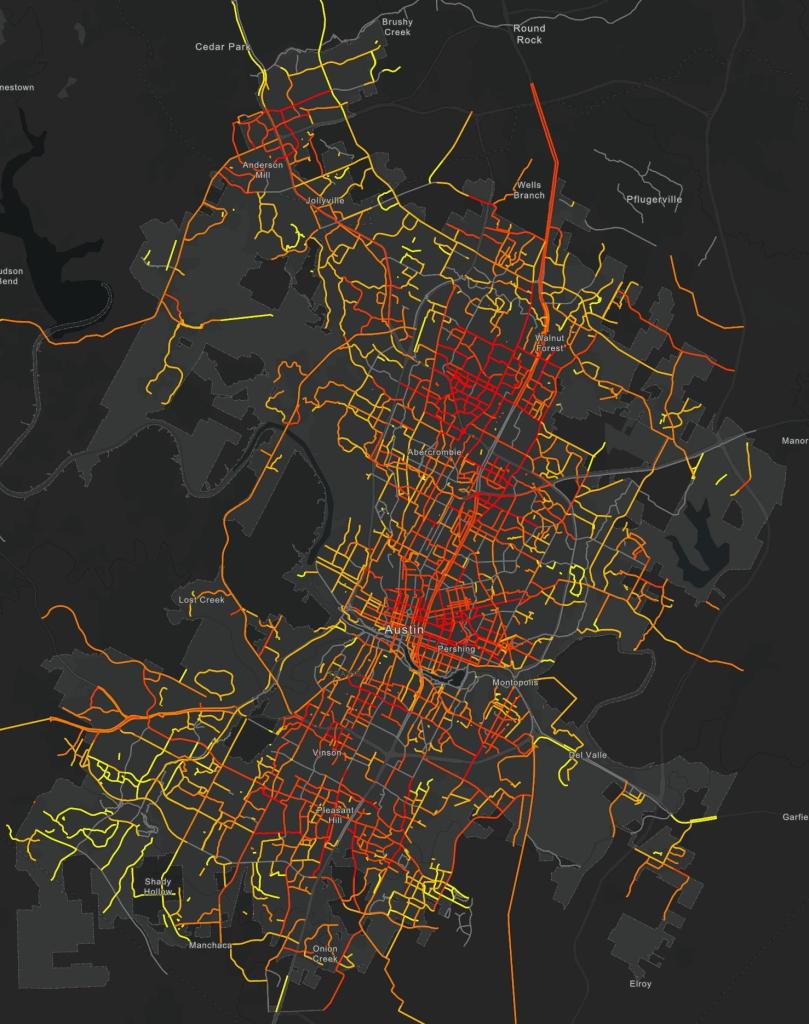
A new data-driven GIS prioritization model was developed (see prioritization map to right) to support project programmatic selection and development. The model includes factors for Equity, Destinations & Travel Demand, Connectivity & Safety, and Cost.
AAA NETWORK BUILDOUT GOALS
AAA Network buildout goals were established as part of this plan that include all build qualities. These goals extend the rate of buildout of the 2014 Plan and current implementation over the next 10 years. If met, in 10 years the network would expand from its current 260 miles to 660 miles (40 miles per year).
The following describes what share of major streets will accommodate people of all ages and abilities at different points of AAA Network buildout:
- 13% of major streets currently accommodate people of all ages and abilities.
- After meeting buildout goals, in 10 years 30% of major streets will accommodate people of all ages and abilities.
- At this rate, full buildout would take 26 years (or the year 2025) and 75% of major streets would accommodate people of all ages and abilities.
INTEGRATION WITH TRANSIT
Integrating with and feeding transit is a major focus of the Plan, given the funding for the first phase of the Project Connect high-capacity transit plan. This plan will prioritize connections to transit stations and recommends utilizing integrated affordability, land use and mobility planning strategies to feed transit not just for a walking radius but a much larger bicycle and scooter catchment of approximately 16 times the land area. More information on transit and bicycle system integration can be found in Chapter 2.
EXPANSION OF THE BICYCLE SHARE SYSTEM
This plan recommends significantly expanding MetroBike, Austin’s public bike share system as a catalyst for mode shift and providing flexible access to bicycle transportation. Now that MetroBike is a Capital Metro service, this system is well-positioned for system expansion and integration with transit serving flexible first and last mile(s) connections. Expanding this system outside of central Austin into supportive and equity focused transit areas is a top priority as well as ensuring that funding for maintenance and operations is adequate to ensure system reliability and effectiveness. More information and recommendations on the MetroBike Share system can be found in chapter 2.
OTHER BICYCLE SYSTEM COMPONENTS
The Plan includes recommendations for other parts of the bicycle system including: bicycle parking, showers, and bicycle facility maintenance needs.
PROGRAMS
While an all-ages and abilities bicycle network is the foundation for increasing bicycle use and creating safer streets, programming is necessary to make the highest use of the infrastructure. Chapter 3 covers program areas, including encouragement and promotion, safety education, and laws and enforcement. Also covered is Austin’s new expanded electric bicycle rebate program by Austin Energy.
A new program focus area, based out of the successful approach used in this planning process, is to establish an ongoing Community Ambassador Program. Community ambassadors would facilitate identify needs, opportunities, and pathways forward through a truly collaborative process between community members and city staff in ways that build long term trust and relationships.
IMPLEMENTATION
A strategic implementation program is laid out in the 2023 Plan and is critical to ensure rapid progress toward implementation. The 2023 Bicycle Plan aligns its implementation framework with Imagine Austin’s five-point approach. The five points of the implementation program are as follows:
- Education and Engagement
- Internal Alignment
- Regulations
- Public Investment
- Partnerships
One of the broad themes of the five-point implementation program is to broaden the support base for bicycling. Implementing the 2023 Plan requires the coordination of all City of Austin departments, partner agencies and organizations, and the public at large. By integrating bicycling as a tool to meet the goals of groups outside of the bicycle program, a broad coalition can be built that will significantly accelerate the realization of the Plan.
The five-point implementation program also focuses on the broad range of avenues to implement the plan. While the plan’s highest priority is to implement an All Ages and Abilities Bicycle Priority Network, realizing this goal will require more than public investment and ultimately requires actions touching each of the five points. The same holds for the other program and bicycle system goals in the Plan. More information can be found in Chapter 4 - Implementation
MEASURING SUCCESS
Ongoing monitoring and evaluation are essential for assessing whether the plan is meeting its goals over time. Measuring actual outcomes through the regular collection of data from bicycle facility use, ridership counts, surveys, mode splits, and other metrics used to track the growth of bicycling over time, along with qualitatively evaluating the user experience is vital. While progress will be assessed over the long-term, data should be collected regularly to help track implementation efforts’ success. This information will allow for adjustments to improve implementation efforts toward the Plan goals. More information can be found in Chapter 5 – Measuring Success.
CHAPTER ONE | INTRODUCTION
The 2023 Austin Bicycle Plan (the Plan) reflects today’s best practices in municipal planning for bicycle- like mobility tools (including tricycles, scooters, and other micromobility devices) at a national and international level. The Plan is an update of the 2014 Bicycle Plan and reflects the latest innovation in approaches. The Plan’s comprehensive approaches work to make Austin a more equitable, affordable, multimodal, safer, healthier, and environmentally sustainable City.
VISION
The 2009 Bicycle Plan focused on what the City of Austin should do to support bicycling. The 2014 Bicycle Plan shifted the focus to what bicycling as a tool can do to help reach the highest goals of the City contained in Imagine Austin Comprehensive Plan. The 2023 Bicycle Plan further builds on the 2014 vision shift to bring a stronger focus on equity.
All Austinites have convenient, practical, and safe choices to take trips by bicycle, tricycle, scooter, or other micromobility devices for all trip purposes. The bicycle network provides equitable access for people of all ages and abilities to local and city-wide destinations, and to connect with nature. Bicycling as a tool is used to provide mobility options and benefits for individuals and help support and realize the City’s highest-level goals for the whole community within the Imagine Austin Comprehensive Plan and other plans and policy goals for our shared equitable and sustainable future.
PURPOSE
The 2023 Bicycle Plan aims to inform and educate the public, government staff, and elected officials of the potential of bicycling to help realize Imagine Austin’s goals, central challenges, strategies to achieve equitable outcomes, and build support for the implementation of this plan. The Plan also provides methods for implementing bicycle infrastructure, policies, and programs for all City departments and partner public agencies; guides community engagement and supporting community goals; and procedures to require and regulate public benefit at the time of new development.
JURISDICTION
The 2023 Plan covers the City of Austin, including its extraterritorial jurisdiction, as an attachment to the Austin Strategic Mobility Plan, and serves as the regulatory document for the provision of bicycle programs and facilities for the City of Austin. The Plan also encourages the City of Austin and surrounding areas to coordinate to create a safe and complete regional all ages and abilities bicycle network.
ACKNOWLEDGEMENT OF ONGOING EFFECTS OF SYSTEMIC RACISM
The City of Austin recognizes that past plans, policies, investments, economics, violence, and trauma spanning the local to international levels have not met the needs of all Austinites and have actively harmed communities - especially low-income communities and communities of color. The structures and effects of systemic racism continue to persist and lay the foundation for inequalities in transportation, health, safety, housing, income, and wealth. The goal of this planning effort to achieve equitable outcomes is impossible without addressing these complex societal inequities and interconnected issues. Achieving equitable outcomes for this plan will require working well beyond the scope of bicycle related policies, programs, and infrastructure as part of a broad movement for a more just society.
“Systemic Racism is a manmade system of oppression created institutionally to exploit, people of color and to maintain a position of social and material supremacy and privilege. This system has generated profound wealth, social, and educational inequities between blacks and whites over different eras but through different means. First through slavery and its lingering effects ending around 1877. Second, the Jim Crow period from 1877 -1964 was marked by its prejudicial legal obstacles. The third period, 1964 to date, includes modern-day forms of discrimination such as markedly higher subprime mortgage rates for people of color. Each period utilized different methods but has perpetuated the wealth, social, and educational inequality we seek to dismantle.” (source: https://koop.org/racial-justice/)
The deep thread of racist action that resulted in systemic racism that continues to be upheld and perpetuated today can be briefly traced to present day relevance to this planning effort:
- Slavery - Over 250 years of slavery and the slave trade in the US only ended approximately 160 years ago. This system, where Black people where considered property and denied ownership of property that was in place longer than it has been abolished and done so without reparations lays the foundation for today’s persistent wealth gap.
Note: This plan borrows heavily from the Dutch who are international leaders in designing streets and mobility systems for all modes, using safe systems approaches, and providing a stronger social safety net. However, it is essential to acknowledge that, like the United States, the Dutch participated and profited greatly from colonialism and the Atlantic slave trade. Wealth derived from these sources contribute to support these modern Dutch best practice systems. - Jim Crow laws between 1870s and 1965 eroded reconstruction era power building and representation for Black people, legalized segregation and led to unequal investment in services and infrastructure.
- Redlining that arose in the 1920s in financial sectors became part of the federal new deal housing policy in 1934 that racially discriminated against communities of color, enforced segregation, withheld resources of credit and insurance, and led to predatory lending loan practices, widening the wealth gap ultimately leading to high
vulnerability of these communities to gentrification and displacement.- “THE IMPLEMENTATION OF THIS FEDERAL POLICY ACCELERATED THE DECAY AND ISOLATION OF MINORITY INNER-CITY NEIGHBORHOODS THROUGH WITHHOLDING OF MORTGAGE CAPITAL, MAKING IT EVEN MORE DIFFICULT FOR NEIGHBORHOODS TO ATTRACT AND RETAIN FAMILIES ABLE TO PURCHASE HOMES. THE DISCRIMINATORY ASSUMPTIONS IN REDLINING EXACERBATED RESIDENTIAL RACIAL SEGREGATION AND URBAN DECAY IN THE UNITED STATES.” (source: https://en.wikipedia.org/wiki/Redlining)
- School Desegregation - Austin is known as a college town where people come for school and never leave, and residents often have higher levels of education. This sentiment refers to the effect of the University of Texas and not Huston-Tillotson University, a historically black university. The segregation of schools was made illegal only in 1954 by the Supreme Court case Brown v. the Board of Education. The educational opportunity at the University of Texas for persons of color was unavailable until 1956. This gap in 12 years from the passage of the G.I. Bill and availability of college education for black men in Austin, indicative of the situation in the south, resulted in significantly different educational benefits from the G.I. Bill and subsequent wealth building. Austin Independent School District was ruled to be in violation of the 1954 Supreme Court ruling until effectively desegregated through two-way student bussing only in 1983.
- Suburbanization, The GI Bill, and White Flight - The federal GI home loans that played a significant role in the rise of segregated suburbs and subsequent wealth building were generally not available to people of color through redlining practices. Historian Ira Katznelson writes, “THERE WAS NO GREATER VEHICLE FOR WIDENING THE ALREADY HUGE WEALTH GAP THAN THE GI BILL.”
- Interstate 35 – Well established patterns of segregation were further reinforced by the construction of Interstate 35 infrastructure barrier between 1950 to 1962 as part of the Interstate Highway System that continues to reinforce these patterns.
- Displacement and Gentrification of Previously Segregated Neighborhoods - Previous segregation policies made underinvested and wealth depleted communities of color easy targets for gentrification and redevelopment. The 1997 Save Our Springs Ordinance set East Austin as the Desired Development Zone in the name of protecting the aquifer recharge zone in affluent west Austin against express wishes of East Austinites. Urban living has become trendy and previously redlined lowest-income neighborhoods were the first affected and began experience rapid population changes and gentrification. Such efforts emptied previously thriving communities to such an extent that numerous East Austin schools were closed, with the justification that there were insufficient populations to maintain them.
- The State’s Property Tax Dependent System actively supports displacement and redevelopment by making homeowners and especially renters without access to homestead exemptions vulnerable to increasing tax bills that outpace income increases. New development affects property
evaluations on long standing communities valuing economic activity over community stability.
The purpose of tracing this history, which some could view as the distant past, is to make the point that the affordability and displacement crisis in Austin is rooted in an intentional legal and policy framework that led to deep economic disparities that put communities of color and low-income at the most risk. As communities of color and low income are displaced to outlying suburbs and “quasi urban” area where the cost saving options walking, taking transit, riding a bicycle or not own a car are no longer possible. This is due to substandard infrastructure, limited connectivity, difficulty / infeasibility of providing effective transit services, and few destinations within walking and bicycling distance. As communities are displaced outside of Austin city limits resources to attempt to address or mitigate the impact on these individuals are no longer available.
Whether the present-day forces are to maintain segregation or for maximum profit, the result is exploiting deep rooted inequities and vulnerabilities. The real estate and redevelopment industries continue to actively support segregation and displacement because predominantly white communities are perceived as higher value. The Urban Displacement Project publishes an interactive map showing the state of displacement and gentrification by neighborhood which continues to be focused on the eastern crescent.
The following section on the ATX Walk Bike Roll Planning Process talks about this plan’s equity centering and the following section frames Three Central Challenges informed by this history and Austin’s continued deep inequities.
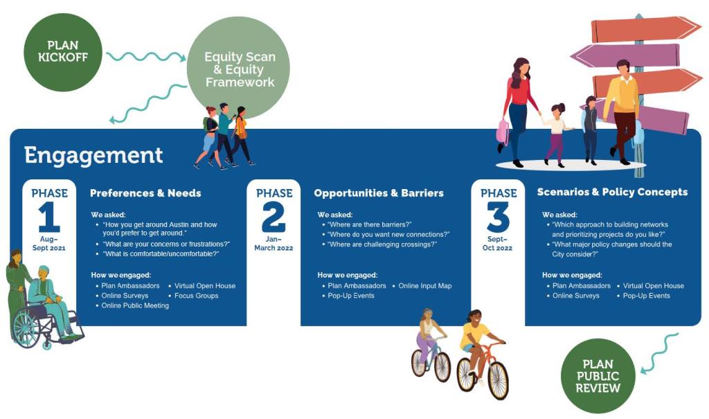
THE ATX WALK BIKE ROLL PLANNING PROCESS
ATX Walk Bike Roll was a coordinated effort by the City of Austin’s Transportation and Public Works Department to update Austin’s Sidewalk, Shared Streets and Pedestrian Crossings; Urban Trails; and Bicycle Plans. These plans guide how we build urban trails, sidewalks, pedestrian crossings, and bikeways and where we need them most. Updating these plans together shows how Austinites have more choices for travel, bringing us closer to achieving the Austin Strategic Mobility Plan (ASMP) goal of increasing how many people walk, bike, or take transit. The guiding values of the ATX Walk Bike Roll process are shown in the text box to the right. ATX Walk Bike Roll centered racial equity throughout the plan update process. Racial equity can be defined as “the condition when race no longer predicts a person’s quality of life outcomes in our community.” The following selection from the ATX Walk Bike Roll Equity Framework highlights the need to focus on racial equity through the three plans:
-
Community influence on active transportation decisions has historically relied on the proactivity of the public. However, we acknowledge that even when communities who have been historically oppressed have advocated for their neighborhoods, the internal practices and biases within the City structure have ignored the concerns and feedback from these communities.
Regional and local advocacy organizations, which may or may not fully reflect Austin’s diversity, were historically the primary or sometimes only stakeholders. In addition, the City prioritized projects requested via services such as 3-1-1 until recently. Practices like these favor neighborhoods with higher capacity for civic involvement. Adverse economic conditions such as low wages, multiple jobs, and digital divide are barriers for participation in traditional civic involvement.
In addition, we acknowledge that since we haven’t fully evaluated the equity of all practices, inequities may continue to be perpetuated in several ways, including: 1) How we prioritize projects, 2) How we engage communities, and 3) How we measure, and therefore evaluate, performance and outcomes.
Guiding Values - ATX Walk Bike Roll is about more than just getting from place to place. Here are a few examples:
- Communities – Urban trails, sidewalks, and bikeways are an important part of our local transportation system. Access to different travel options influences how communities grow, where we choose to live, and how we interact.
- Equity and Diversity – Austin’s transportation options need to serve everyone. A person’s life experience, race/ethnicity, cultural background, or ability should not make it harder for them to get around.
- Mobility and Accessibility – Walking, biking, and rolling are safe, affordable, and don’t require a license. Because sidewalks, urban trails, and bikeways are available to a broad range of ages and abilities, they help create more opportunities for people to participate in their community.
- Health and Environment – Our transportation system impacts our physical, social, mental, and environmental health. People will walk, bike, or roll more often when they have safe and easy routes to take. This can help cut down on car traffic and its negative environmental impacts.
- Connections – Urban trails, sidewalks, and bikeways connect communities to businesses, parks, and neighborhoods.
-
Transportation and Housing Affordability – As Austin grows, so do housing costs and the cost of transportation. ATX Walk Bike Roll can help by providing a low-cost way to travel through a network of sidewalks, bikeways, and urban trails with easy access to transit throughout the city.
APPLYING THE EQUITY FRAMEWORK
The Equity Framework offered guidance on how to center equity at each stage of the planning and decision-making process. As part of this, a concerted effort was made during ATX Walk Bike Roll to ensure that participation in community engagement “exceeds the racial/ethnic and income demographic makeup of the city and reflects the voices of those most negatively impacted by the process” (from the ATX Walk Bike Roll Equity Framework). This effort came short of meeting this goal; however, when reviewing public input results, comments received from the focus population were compared to total responses to review differences and elevate input received from the focus population. Targeted engagement strategies, including paid Community Ambassadors and Spanish-language focus groups, were used beyond online self-selecting engagement to reach the focus populations (see definition to the right) for this effort: Robust engagement will continue as well as the Plan is implemented on a project-by-project basis.
Among the many complaints, focus populations were indifferent to participation based on pointed stonewalling of previous efforts. Long-term residents were tired and cynical that further input would cure any injustices, and younger residents were generally facing economic distress. They were forced into single-occupancy vehicles based on the locations of their housing.
What we heard
“Low-income and minority segments of town are vastly undeveloped and underserved by Austin’s historic transportation plans leaving them without the necessary transportation infrastructure needed to thrive in their communities.”
- Engaging with communities and individuals throughout ATX Walk Bike Roll was crucial, especially to understand community priorities and to seek public direction on key policy and investment decisions. Public input, guided by the Equity Framework, steered the planning process at strategic points throughout ATX Walk Bike Roll through multiple phases of community engagement. In each phase, the team focused on tailored questions to receive constructive feedback from the public to shape the updated plans.
- These green color text boxes throughout this document highlight what we heard through community engagement and how the feedback received is incorporated into this Plan.
- The ATX Walk Bike Roll process prioritized engaging with people of color and people with low incomes. In several locations throughout this document, we refer to “focus populations” as shorthand to refer to this group which is defined as Black, Hispanic/Latinx, and other people of color, and those earning less than 80 percent of the median household income.
- More information on the planning process, the Equity Framework, and outcomes of community engagement during the ATX Walk Bike Roll process can be found in a separate document.
What we heard
Throughout the ATX Walk Bike Roll process, concerns about affordability and displacement were shared—especially by people of color and people with low incomes. Policies to address these issues and keep transportation affordable are essential to peoples’ ability to happily live and thrive in the city. In the words of one community member, people are “concerned that urban trails and sidewalk improvements are benefiting wealthy white residents... that people of color and low-income residents are being pushed out, and that people of color will not be around in 5-10 years from now, after additional improvements to sidewalks, bike lanes, and urban trails.”
The importance of place-based equity is highlighted by this participant’s quote: “This all seems great, but don’t forget about the existence of Northeast Austin in your plans. The availability of transit, safe walking routes, and urban trails is non-existent north of Rundberg.”
To provide consistency in measuring equitable outcomes across the plans and other City initiatives, Austin Transportation developed Equity Analysis Zones with community members to understand which areas of Austin have higher concentrations of historically marginalized populations and their degree of vulnerability. Equity Analysis Zones (EAZ) are based on Census tracts and include nine different US Census American Community Survey (ACS) variables that reflect an area’s social and economic vulnerability. The EAZs are classified into five categories, from Least Vulnerable to Most Vulnerable.
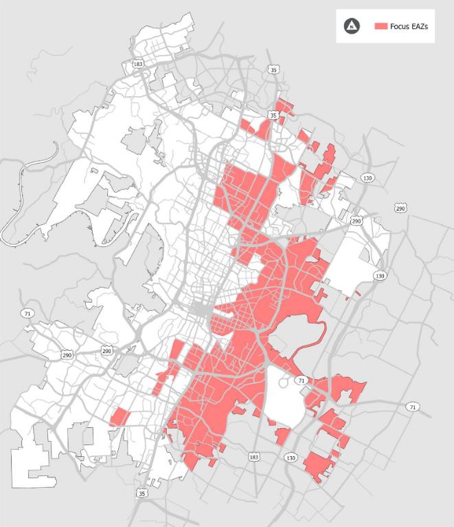
Figure 1-3 shows that most of the Most Vulnerable and Medium-High Vulnerable Equity Analysis Zones are located on Austin’s east side. Many of these areas were targeted through a historic practice called redlining, where banks and other institutions withheld investment based on the racial/ethnic or economic make-up of the community and more recent policies such as the Desired Development Zone, which directed developers to target East Austin communities instead of evenly dispersing their efforts throughout the city. Many of these areas are now experiencing high rates of displacement. More information on EAZs and historical inequities in planning and development in Austin can be found in the ATX Walk Bike Roll Equity Framework.
The ATX Walk Bike Roll Equity Framework was applied to this Plan by engaging with, evaluating impacts for, and prioritizing the needs of people of color and people with low incomes who have historically been underserved or negatively impacted by planning and infrastructure decisions.
THREE CENTRAL CHALLENGES
With the 2023 Bicycle Plan centered on equity there are three central challenges.
- Continuing the enormous task of reshaping the built environment of our city, so people have safe streets and trails that provide mobility choices.
- Addressing the affordability and displacement crisis, which, if not addressed, will make it impossible to provide equitable access to mobility choice.
- Changing attitudes and systems of thought to build empathy, understanding, and respect for all.
MOBILITY CHOICE
The first challenge of making bicycling convenient, safe, and practical, is enormous given Austin’s car-centric, suburban, and sprawled development trends and policies for more than half of a century. Despite this this effort is well underway due to historic levels of funding authorized by voters in 2016, 2018, and 2020 Bonds as well as a comprehensive update of the Transportation Criteria Manual in 2022. The All Ages and Abilities Bicycle Priority Network envisioned in the 2014 Bicycle Plan is rapidly expanding but is still far from providing all Austinites safe places to make trips by bicycle, scooters, other micromobility devices, and motorized wheelchairs. It is critical to equitably prioritize investments in this network and that projects are developed with the community through robust community engagement.
Austin’s bikeway infrastructure implementation is getting more sophisticated and works towards a high-quality standard utilizing protected intersections, bicycle signalization, and higher-quality physical protection in phased approaches to balance rapid large scale network buildout with increasing quality over time. The Bikeways Program also partners and co-funds projects with other programs like Safe Routes to School, Vision Zero / Safety, Urban Trails, Sidewalks, Transit Enhancement, and other programs to achieve more integrated and holistic outcomes.
AFFORDABILITY, DISPLACEMENT, AND INEQUITIES IN OUTCOMES
The second challenge of addressing the affordability and displacement crisis is a broad and existential challenge affecting all aspects of life in Austin.
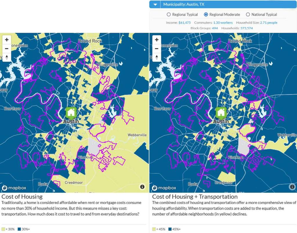
At the time of the 2014 Bicycle Plan, affordability and displacement were only an acute concern in neighborhoods experiencing high levels of gentrification due to a long history of discriminatory practices and policies and a lack of political support to protect these vulnerable communities. These issues were starting to become a community-wide issue of concern, but they were not yet at the crisis level of today as the pressures of economic development are creating strain for even middle-class Austinites. In 2014 mobility needs consistently surveyed as the top city-wide concern and now affordability and displacement are the overwhelming top concern for living in Austin. People with low and middle incomes are increasingly unable to afford to live in older, more central, and more walkable and bikeable places.
Mobility systems and development patterns are interconnected in complex ways that affect whether a person has access to mobility choices other than driving to where they need to get to. For example, the older and more central parts of the city generally have a more connected street network and a variety of land uses and destinations that better support short trips by walking, bicycle, and viable transit service. By contrast, the places that vulnerable populations are being displaced to often have less connected street networks resulting in longer trips and large areas of single-use zoning that result in destinations being further away and more car-dependent. This includes many low-income service workers who are increasingly required to bear the additional costs of owning and maintaining a vehicle to access employment.
Even if we achieve success in the first challenge and have made safe places for people to travel by bicycle and scooter, it will do nothing for the people who can no longer afford to live in that neighborhood or even within the Austin city limits eroding our best efforts to achieve equitable outcomes.
Addressing this challenge will require a community-wide approach using all tools and approaches including stronger management of affordability; conducting more integrated land, affordability, and mobility planning; and working across all levels of government to find solutions to this problem affecting many cities in the nation.
CHANGING ATTITUIDES AND BUILDING EMPATHY, UNDERSTANDING, AND RESPECT
When we talk about how physical infrastructure and environments are going to be developed it is critical to also talk about how infrastructure is also systems of thoughts and community attitudes about things. For truly equitable outcomes, it is necessary and there needs to be a plan to develop compassion towards people that these plans are intended to benefit (inclusivity).
We need to change the mentality that only people of means deserve to have transportation options or the ability to live in places that gives access to opportunity because they earned it or are more worthy than our community’s most vulnerable. In contrast to verbal abuse from people driving towards people who look different or get around in different ways, we need streets and a society where everyone is respected.
If this plan aims to achieve equitable outcomes, it is necessary to reevaluate every aspect of the societal fabric and its systems that hold back treating each person with respect and dignity and equitable outcomes for this plan. The scale of the challenge is immense and will only be possible with a comprehensive approach working across causes, silos, partners, programs, agencies, and all levels of government with all available tools.
ACHIEVEMENTS SINCE 2014 BICYCLE PLAN
Much has happened since the adoption of the 2014 Bicycle Plan. Shortly after its adoption, Austin City Council transitioned from 7 Council Members elected at-large to a 10-One system with 10 City Council Members elected from single-member districts and one mayor elected at-large. The goal of the new 10-One system was to address long standing disproportionate elected representation by a small number of influential and affluent neighborhoods to improve representation and accountability for all.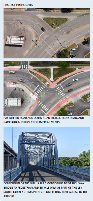
Under the leadership of the new council, with mobility ranking as the top issue of the time and through a robust public engagement process, Austin’s largest and most progressive mobility bond was developed and approved by voters in 2016. The vision for the All Ages and Abilities (AAA) Bicycle Priority Network in the 2014 Bicycle Plan got the highest level of public support in the development of the bond and helped shape its final form.
Additional mobility and safety bonds were approved by voters in 2018 and 2020, setting the stage for today’s interrelated mobility infrastructure programs that collaborate to implement the bicycle network portion of this plan: Bikeways, Urban Trails, Safe Routes to Schools, Vision Zero / Safety, Sidewalks, Ped Crossing Program, Transit Enhancement, Corridor, Substandard Street, and Regional Programs. Due to the levels of funding and strict timelines set by the council and approved by voters, these programs are all working at higher magnitudes and significantly increased staff capacity and expertise, allowing them to address more challenging and sophisticated infrastructure problems.
In June of 2021, the All Ages and Abilities (AAA) Bicycle Priority Network celebrated a significant milestone of completing 50% of the mileage called for in the 2014 Plan. As of the time of this plan, the completed AAA Bicycle Priority Network is 232 miles including over 15 high-quality protected intersections with many more in design. Over 100 miles of the network are in active development.
Other successes of this plan have been the subsequent update to the Strategic Mobility Plan (ASMP) and Transportation Criteria Manual (TCM) that make national and international best practices in multimodal street design the standard for how we design streets in Austin.
Review of collaboration with regional capital projects to meet Complete Streets goals of this plan have been generally successful. Following the funding of the $7.5B Project Connect System Plan, collaboration with the design team is going well to align the Bicycle Plan’s recommendations with the initial buildout phase. There has also been significant success working with the Texas Department of Transportation (TxDOT) and the Central Texas Regional Mobility Authority (CTRMA) in making regional highway projects safer for people walking and bicycling including shared use paths, lighting, safety-conscious intersection design and support of transit needs.
Transportation review of new development projects has become much more sophisticated and consistent in achieving ASMP and Bicycle Plan-aligned outcomes with the establishment of the Transportation and Public Works Department’s Transportation Development Services Division. The establishment of the Street Impact Fee in 2022 is also a powerful tool to fund the upgrade of substandard streets to new multimodal TCM standards, paid for by development traffic impact fees.
MetroBike, Austin’s public bike share system, previously known as B-cycle, has seen continued success and expansion, and is now managed by Capital Metro and better poised to grow and meet the mobility needs more broadly in Austin.
CONTINUED BEST PRACTICES
The significant shifts in the 2014 Plan were to focus on designing for all ages and abilities, catching quick trips, and building a complete network. These strategies are now the norm and operationalized in the 2019 Austin Strategic Mobility Plan and the Transportation Criteria Manual, updated in 2022 for the first time in 25 years, and large-scale multimodal infrastructure funding primarily by the 2016, 2018, and 2020 bonds. All of this has led to a significant increase in the sophistication and breadth of our infrastructure programs to make a safer mobility system that serves all modes.
DESIGNING FOR ALL AGES AND ABILITIES
Local and national studies have found that approximately half of the population is “interested but concerned” in bicycling for transportation as they are concerned for their safety on the roads. In Austin, 55 – 60 % of its population is interested in bicycling in protected lanes, trails, and other all-ages and abilities infrastructure. However, less than 15 % of Austinites will ride in a painted bicycle lane on a busy street. Designing for all ages and abilities is now the norm, and more information can be found in the section Designing for All Ages and Abilities.
CAPTURING SHORT TRIPS
Bicycling, like walking, is best suited for short trips. As a result, short driving trips of less than three miles (and longer, particularly for e-bikes) are the most likely to be converted to bicycle trips. To maximize the benefit of the investment in protected bicycle lanes, the implementation should give additional priority to areas that have concentrations of short trips. More information is in Chapter 2 Bicycle System, section Capturing Short Trips.
BUILDING A COMPLETE BICYCLE NETWORK
There is an international focus on the importance of complete networks that serve people of all ages and abilities. Quickly building a complete all-ages and abilities bicycle network is a powerful tool to serve travel demand, create mode shift, and get the benefits from reduced driving. This was a core strategy of the 2014 Bicycle Plan, and significant funding was received in the 2016, 2018, and 2020 Mobility Bonds. More information can be found in Chapter 2 Bicycle System, sections Building a Complete Bicycle Network and the All Ages and Abilities Bicycle Priority Network.
“LONGTIME CYCLIST AND USER OF BIKE LANES. I’VE HAD RUN-INS WITH CARS AND HAVE ALMOST BEEN HIT MULTIPLE TIMES. I DO NOT FEEL SAFE RIDING IN AUSTIN. THE CARS ARE TOO BIG, TOO FAST, AND THEY DO NOT RESPECT CYCLISTS. WOULD LIKE TO SEE MORE PROTECTED BIKE LANES THAT ARE SEPARATED FROM CARS.”
Dutch Inspiration
The City of Austin held a Think Bike Event in November 2012. The event brought a team of world-leading Dutch planners, designers, and policy makers to Austin to share experiences in a three-day workshop. The results of this workshop included the framework for the All Ages and Abilities Bicycle Priority Network and a re-envisioned South Lamar Boulevard, a key bicycle corridor. Ideas shared became foundational planning concepts of the 2014 Bicycle Plan including “design for all ages and abilities,” “catch short trips,” “build complete networks,” “feed transit,” and “get used to spending more money on bikes.”
A second Think Bike Event was held on the 10-year anniversary in November of 2022 to celebrate 10 years of accomplishment and also to look forward at current challenges and opportunities. Workshops focused on Policy, Bicycle Infrastructure and Safe Systems, and Transit and Bicycle System Integration.
FEEDING TRANSIT
While this was a core strategy of the 2014 Bicycle Plan, with the adoption and funding of Project Connect system plan, this is an area of renewed focus. Using bicycles and scooters to feed transit allows catchment of 1.5-2 miles compared to a ½ mile walking radius resulting in a 16 times larger land area. AAA Bicycle Priority Network planning focused on each planned Commuter Rail, Light Rail, Rapid, and Frequent Commuter Bus station during this update. Implementation of these network segments will be prioritized to coincide with the opening of these stations and transit lines over the coming decade as well as providing secure bicycle parking as part of Transit Stop Design. More information can be found in Chapter 2 Bicycle System, section Feeding Transit. Also related is shaping land use and affordability around these transit hubs and neighborhood centers explained more in the 15 Minute Cities and Integrated Land, Mobility and Transit Planning sections below.
NEW FOCUS AREAS
The 2023 Bicycle Plan includes several new focus areas. Many of these serve to work towards solutions to more significant and complex issues around equity, planning for a rapidly changing Austin, addressing intersectional issues, and changing tools for mobility.
MANAGING AFFORDABILITY AND DISPLACEMENT
As discussed in the second central challenge, one of the biggest themes we heard through the ATX Walk Bike Roll public engagement, particularly from focus populations, was significant issues with affordability and displacement.
A fundamental driver of this issue results from the intensity of economic development in Austin and the region. A principle that development should pay for itself has been applied to areas such as traffic mitigation and parkland dedication. From the vantage point of the City’s most vulnerable populations, development does not pay for itself, and more robust programs, policies, and regulations are needed to not leave people behind.
Another critical question that needs to be addressed is what level and character of economic growth is possible while not leaving people behind and honoring the third central challenges of building empathy, understanding, and respect for all members of our community.
“THE CITY NEEDS TO INVEST MORE RESOURCES IN LISTENING TO RESIDENTS OF COLOR AND IMPLEMENTING POLICIES THAT VULNERABLE POPULATIONS WANT. I WANT TO SEE SIDEWALK AND BIKE LANE IMPROVEMENTS THAT ARE COUPLED WITH “RIGHT OF RETURN” AND OTHER HOUSING POLICIES THAT KEEP PEOPLE IN THEIR HOMES AND PREVENT GENTRIFICATION.”
Managing these issues needs to be a top City-wide priority where all tools, approaches and disciplines work together to implement holistic solutions. Some of the solutions may be within local control such as continued anti-displacement efforts, increase in preservation and construction of affordable housing, multidisciplinary land, affordability and mobility planning. Other strategies will require working towards solutions at other levels of government including county, state, federal, also discussed in the Implementation Chapter, section external alignment.
Another aspect of managing household affordability is managing transportation costs. Transportation costs are the second highest household expense behind housing. Bicycling, scooter, tricycle, and other micro-mobility are an opportunity to significantly reduce transportation costs through driving less or reducing the number of cars in a household. To equitability provide this opportunity to reduce transportation costs requires that everyone has access to this opportunity.
Beyond managing affordability and displacement which relates to where people are able to live and if that area is conducive to bicycling, it will be important to equitably build out the all ages and abilities bicycle network, conduct integrated planning, provide affordable access to bicycle and electric bikes and public bike share, and ensuring that people, including those in older apartments, have secure places to store their bicycles and electric bicycles.
INTEGRATED LAND, AFFORDABILITY, MOBILITY PLANNING FOR HOLISTIC OUTCOMES
This section covers frameworks and need for integrated land, affordability, and land planning including the 15-Minute City concept, the Equitable Transit Oriented Development initiative as part of Project Connect, and Imagine Austin Centers and Corridors. These concepts are polycentric development patterns that would have many city and neighborhood density centers that would meet diverse societal needs within reasonable walking and bicycling distances.
Acknowledgement of risks for land development strategies: While it is critical to find ways to transition our City’s car-centric suburban land use patterns to ones that are more multimodal, more affordable, and with lower environmental impacts it is necessary to acknowledge and adequately mitigate the risks of land [re]development strategies on affordability and displacement. It is necessary for holistic regulations, policies, programs, and strategies are in place to ensure that development and redevelopment strategies supports community goals and needs rather than exploitatively extracting value from areas of change. New development and public private partnership will have to be financially viable, but it is critical for community goals and needs to be driving any redevelopment process.
15-Minute City concept is a way to ensure that urban residents can fulfill six essential functions within a 15-minute walk or bike from their dwellings: living, working, commerce, healthcare, education, and entertainment. The framework of this model has four components: density, proximity, diversity, and digitalization. The 15-minute city is a proposal for developing a polycentric city, where density is made pleasant, one's proximity is vibrant, and social intensity (a large number of productive, intricately linked social ties) is real. The C40 Cities Climate Leadership Group report highlights the importance of inclusive community engagement through mechanisms like participatory budgeting and adjusting city plans and infrastructure to encourage dense, complete, overall communities. Source: 15-minute city, (2022, December 30th), In Wikipedia.
Planning for Equitable Transit Oriented Development (ETOD) is part of a CapMetro and City of Austin partnership as part of Project Connect transit investment. This effort is intended to mitigate issues with equity outcomes of past Transit Oriented Development (TOD) in Austin where station area redevelopment has led to issues with affordability and displacement. This plan recommends integrating bicycle mobility tools and network prioritization to support ETOD goals while significantly increasing the catchment areas for transit beyond walking distances. More information can be found in Chapter 2 Bicycle System, section Evolving Traditional Transit Oriented Development to Equitable Hybrid (Walk+Bike) Transit Oriented Development.
The 15-Minute City concept is related to the Imagine Austin Comprehensive Plan Centers and Corridors concept. The Imagine Austin Comprehensive Plan designated regional centers, town centers, neighborhood centers, activity corridors, and activity centers as places where there is a desire to create a dense mix of uses to encourage walkable, bikeable, and transit-friendly areas. This type of mixed-use infill development pattern is one of the primary strategies in the Plan to accommodate the population growth in Austin. Infill development supports diverting short driving trips to walking and bicycle trips.
Whether it is new planning for 15-Minute City centers, Project Connect’s Equitable Transit Oriented Development (eTOD) effort, or previously identified Imagine Austin Centers and Corridors there is a potential for a significant concentration of short trips and meeting broader plan goals and outcomes in these areas. These areas will be an ongoing focus for multidisciplinary land, affordability, and mobility. Recommendations on proactive approaches to multidisciplinary planning can be found in Chapter 4 Implementation, section Multidisciplinary Land, Affordability, and Mobility Planning.
IMPROVING QUALITY OF PROTECTED BICYCLE LANES AND INTERSECTIONS
Through this planning process and through individual public processes City staff consistently hear about the need to increase the quality of protected bicycle lane and intersection physical protection beyond the most frequently used paint and post approach. This Plan recommends a phased approach initially using quick build strategies to quickly create city-wide connectivity for people of all ages and abilities and phased approach to later achieve the full build quality including concrete or planted barriers for bike lane protection, protected intersections, shade, and green infrastructure. This plan sets aggressive goals for achieving full-build quality concrete protected bicycle lanes, protected intersections, and high-quality bus stops. More information can be found in Chapter 2 Bicycle System, section A Phased Approach: Quick Build vs. Full Build and section Bicycle Network Strategies and Actions in Review.
EQUITABLE PRIORITIZATION FOR THE ALL AGES AND ABILITIES BICYCLE PRIORITY NETWORK
This plan update includes a new equity centered data driven prioritization methodology for selection of projects as part of the All Ages and Abilities Bicycle Priority Network Buildout.
This Plan also expanded the 2014 Plan’s focus on developing a basic city-wide network to a more robust network around the three themes identified through the planning process: access to neighborhood destinations, access to nature, and access to city-wide destinations. These themes better capture the variety of trips that people want and need to take, and all three received strong support from stakeholders in the ATX Walk Bike Roll planning process including focus populations. More information on each theme can be found in Chapter 2, section Prioritization Themes for the AAA Bicycle Priority Network.
CLIMATE, CLIMATE RESILIENCY, SHADE, GREENING STREETS, AND WATER MANAGEMENT
This broad set of related intersectional issues had strong attention in the planning process with many resulting action items. With a significant portion of US greenhouse emissions coming from the Transportation sector (27% of from the transportation sector and 57% of that share coming from light-duty vehicles), bicycles, scooters, walking, transit, and better land uses all have the potential to significantly reduce emissions that affect climate change. Building broad coalitions that understand these interconnected systems and how they can equitably change to support climate goals will be necessary to make changes at a level that has a meaningful impact on climate change (source: EPA). Building broad coalitions that understand these interconnected systems and how they can equitably change to support climate goals will be necessary to make changes at a level that has a meaningful impact on climate change.
Other aspects of the plan are in response to the realities of climate change, such as the need for shade and inequities to vulnerability to heat due to different population health risk factors, the extent of shade canopy in other parts of town, and different patterns of getting around. More information on these issues can be found in the study Keep Austin Cool: Addressing Urban Heat Health Risk in Austin, TX.
“Redlining and Environmental Racism
Decades of redlining and other discriminatory practices reshaped urban landscapes in Austin and across the country, leaving some areas 10 degrees hotter than others*. Today redlined areas face worse urban heat, largely due to a lack of trees and vegetation.A 2020 study in the peer-reviewed Climate Journal found that in more than 100 American cities, neighborhoods that were “redlined” in the 1930s, meaning they were deliberately discriminated against on racial grounds in home loans and other economic support—are today, on average, about 4.7 degrees Fahrenheit hotter than un-redlined neighborhoods in the same city.”
Sources: https://koop.org/racial-justice/ & The Effects of Historical Housing Policies on Resident Exposure to Intra-Urban Heat: A Study of 108 US Urban Areas, Published: 13 January 2020, Climate 2020, 8(1)*Note: Lack of shade creating barriers to walking and bicycling in Texas summers is not limited to red-lined areas. Much of our suburban land development was built without adequate shade and the downtown area can have many hot spots due to lack of shade and glass building reflections.
To address this, shade trees and places to rest are essential parts of active transportation infrastructure and need to be planted in ways that are resilient to more extreme temperatures and droughts. Recommended actions work to remove barriers to implementation, and plant trees for shade along existing infrastructure and new projects and create dedicated team to shade high needs & vulnerability areas. Focus should be given to providing shade at intersections where people must wait to cross streets as well as providing minimum standard of shade coverage or interval along streets. Explore public-private partnerships and novel approaches to implement at large scales and lowered costs. Supporting tree health and green street elements that bring nature into the city will require innovative approaches that use natural rainwater for irrigation to reduce costs and improve resilience. More information can be found in Chapter 2 Bicycle System, section Shade and Green Infrastructure.
PHYSICAL AND MENTAL HEALTH
Implementing aspects of this plan have the potential for strong positive impacts on overall community health. Community health has long been an important issue where outcomes depend on many factors including economic status and race that has gained broader attention due to the pandemic and racial reckoning of the last few years. Potential positive impacts range from health outcomes from safer streets that result in fewer (potentially life changing) injuries that provide shade and protect from heat risk factors to improved physical, mental, and social well-being from integrating physical activity into daily life and having opportunities to interact with each other outside motor vehicles.
From the Center for Disease Control:
“HEALTH EQUITY IS THE STATE IN WHICH EVERYONE HAS A FAIR AND JUST OPPORTUNITY TO ATTAIN THEIR HIGHEST LEVEL OF HEALTH. ACHIEVING THIS REQUIRES ONGOING SOCIETAL EFFORTS TO:
- ADDRESS HISTORICAL AND CONTEMPORARY INJUSTICES
- OVERCOME ECONOMIC, SOCIAL, AND OTHER OBSTACLES TO HEALTH AND HEALTH CARE
- ELIMINATE PREVENTABLE HEALTH DISPARITIES TO ACHIEVE HEALTH EQUITY, WE MUST CHANGE THE SYSTEMS AND POLICIES THAT HAVE RESULTED IN THE GENERATIONAL INJUSTICES THAT GIVE RISE TO RACIAL AND ETHNIC HEALTH DISPARITIES. THROUGH ITS CORE STRATEGY, CDC IS LEADING THIS EFFORT, BOTH IN THE WORK WE DO ON BEHALF OF THE NATION’S HEALTH AND THE WORK WE DO INTERNALLY AS AN ORGANIZATION.
HEALTH DISPARITIES ARE PREVENTABLE DIFFERENCES IN THE BURDEN OF DISEASE, INJURY, VIOLENCE, OR OPPORTUNITIES TO ACHIEVE OPTIMAL HEALTH THAT ARE EXPERIENCED BY POPULATIONS THAT HAVE BEEN DISADVANTAGED BY THEIR SOCIAL OR ECONOMIC STATUS, GEOGRAPHIC LOCATION, AND ENVIRONMENT.[1] MANY POPULATIONS EXPERIENCE HEALTH DISPARITIES, INCLUDING PEOPLE FROM SOME RACIAL AND ETHNIC MINORITY GROUPS, PEOPLE WITH DISABILITIES, WOMEN, PEOPLE WHO ARE LGBTQI+ (LESBIAN, GAY, BISEXUAL, TRANSGENDER, QUEER, INTERSEX, OR OTHER), PEOPLE WITH LIMITED ENGLISH PROFICIENCY, AND OTHER GROUPS.”
In 2018 the City and Travis County completed a Community Health Improvement Plan (CHIP). The CHIP works to implement Imagine Austin's Healthy Austin strategies related to food access, transportation, the built environment, obesity, and access to healthcare. Changes to the built environment that support active transportation are key avenues to implement recommended prevention strategies.
Findings in the CHIP support the equity centered and integrated strategies recommended in this plan including providing access to safe streets that enable active transportation and recreational opportunities; need to holistically address issues with affordability, displacement, and access to services; and need to reevaluate the prioritization of bikeway infrastructure.
"RESIDENTS AND PROFESSIONALS DISCUSSED DISPLACEMENT OF LOW-INCOME BLACK/AFRICAN AMERICAN AND LATINO/HISPANIC RESIDENTS TO MORE AFFORDABLE AREAS OUTSIDE OF CENTRAL AUSTIN WITH LESS ACCESS TO AFFORDABLE HEALTH CARE, HEALTHY FOOD RETAILERS, OUTDOOR RECREATION SPACE, AND MEANS OF TRANSPORTATION"
"RESPONDENTS INDICATED THAT SOME NEIGHBORHOODS ARE WELL SERVED WITH ACCESS TO PARKS, TRAILS, AND RECREATION CENTERS, BUT OTHER NEIGHBORHOODS ARE UNDERSERVED AND LACK ACCESS TO FACILITIES AND INFRASTRUCTURE TO SUPPORT PHYSICAL ACTIVITY AND WELL-BEING."
METROBIKE – AUSTIN’S PUBLIC BIKE SHARE SYSTEM
Austin’s Bike Share system, MetroBike has continued to grow. As of 2020, it is managed by Capital Metro, making it well-positioned for continued expansion, full electrification, and continued integration with transit services and stations. One significant benefit of the MetroBike system is the cost to the user compared to scooter and micromobility services. At the time of this plan, an annual pass is under $90 a year and allows unlimited trips under 1 hour and low-income residents can get an annual membership for $5 per year. This plan recommends significant expansion of Austin’s bike share system to expand its reach and cost saving benefits outside central areas, focusing on access to transit stations and low-income regions and increased investment in system maintenance to provide reliable, non-owned access to bicycle mobility. More information can be found in Chapter 2 Bicycle System, section Bike Share System.
ELECTRIC BIKES, SCOOTERS, MICROMOBILITY DEVICES, AUTONOMOUS VEHICLES, AND MOBILITY SERVICES
Over the last ten years, e-bikes, e-cargo bikes, scooters and micromobility service providers have gone from early adoption to widespread use. These tools significantly expand the reach and accessibility for people to utilize the bicycle network for mobility purposes. They expand the trip range and speed, alleviate hills and heat, open bicycling use and benefits of bicycle infrastructure up to a broader spectrum of physical abilities and make moving heavier loads, particularly with cargo bikes, possible. In the US, 33% of bike sales are now electric; in the Netherlands, it is up to 50%. Various commercially available cargo bikes with electric assist are now popular, giving people solutions to carry kids, groceries, and other loads.
The City of Austin increased its electric bike rebate program in 2022, designed to make electric bicycles which are a powerful alternative to specific car trips, more accessible to all. The new rebate also includes increased rebates for low-income residents. This plan sees tremendous potential in this program and recommends ongoing monitoring of the use and funding of this program, proactive outreach to low-income communities. More information can be found in Chapter 3 Programs, section Electric Bike Rebate Program.
Another benefit of AAA Bicycle infrastructure is it often provides a desirable and safe place for people using electric wheelchairs. Because bicycle infrastructure is designed for higher speeds than sidewalks these pathways are often more comfortable for people traveling at higher speeds in electric wheelchairs.
The rapid proliferation of scooters and other micromobility services resulted in a near overnight doubling of the number of people on two wheels getting around when these services showed up in 2018. Concerns with users of these services on downtown sidewalks and in congested vehicle lanes led to a rapid increase in the demand for AAA bicycle infrastructure. Due to the number of units these services have in Austin, it is possible to access a rental electric scooter or bike from almost anywhere in Austin. These services give people options for flexible car alternative trips without the need to own a bike or scooter.
It is critical that any electric mobility devices used in all ages and abilities bicycle infrastructure not undermine the safety and inclusion goals of that infrastructure. Most importantly it is necessary that any electric powered devices be regulated for top speeds of 20 MPH.
More information can be found in Chapter 2 Bicycle System, section Electric Bikes, Scooters, and Other Micromobility Services.
Autonomous vehicles are an important emerging technology that could have profound impacts to street safety, opportunities to rebalance use of the right of way, greater mobility choices and even our land patterns. Done well, the proliferation of autonomous vehicles could have enormous positive benefits supporting our established mobility and city-wide goals or it could undermine them. The National Association of City Transportation Officials provides excellent policy guidance resources on this topic. Action items related to autonomous vehicles can be found in Chapter 2 Bicycle System, section Bicycle Network Strategies and Actions in Review.
BETTER SOCIAL SUPPORT SERVICES
Like the Austin Strategic Mobility Plan, this plan recognizes that taking better care of the most vulnerable in society is necessary to achieve equitable outcomes called for in this plan.
More information can be found in the Austin Strategic Mobility Plan, Chapter 6 Supporting our Community, Equity Policy #5: Prioritize serving the most vulnerable populations in Austin by supporting broader efforts to provide social services.
THE PLANNING FRAMEWORK
The 2023 Bicycle Plan is one of many plans that work together to shape our community and create the place Austinites have envisioned. The Plan, as an appendix to the Austin Strategic Mobility Plan, serves as the regulatory document for the provision of bicycle programs and facilities for the City of Austin. The following gives an overview of the planning framework that surrounds the Plan.
While it is important to understanding how this plan relates with other City and regional plans, policies, and regulations, it is necessary to be critical of each of the following to understand their vintage, equity consciousness, modal bias, and processes from which they were derived. If any of these plans were updated today, they should be assumed to be held to a higher equity centered standard and more progressive view of multi-mobility that would address omissions, wrong-doing and biases that may be contained in them. It is with this note that the following are referenced as relevant to this Plan.
ACTIVATING IMAGINE AUSTIN (2012)
In 2012, the City of Austin adopted Imagine Austin, the first citywide comprehensive plan in 35 years. It captures the community’s collective vision for how residents want to shape the city as it grows. It contains 6 guiding principles and 8 priority programs that have strong synergy with goals and recommendations in this plan.
SUPPORTING THE AUSTIN STRATEGIC MOBILITY PLAN
The Austin Strategic Mobility Plan (ASMP) is Austin's first comprehensive, multimodal transportation plan, and guides our short- and long-term transportation projects, programs, initiatives, and investments. Adopted in April 2019, the ASMP plans for all the ways we get around Austin. This includes driving, walking, bicycling, rolling, and taking public transportation. The ASMP also addresses how mobility systems relate to the success of other systems and goals such as affordability, land use, and equity.
The ASMP includes a Street Network Table and Street Network Map that show Austin’s vision for improvements to the street network over the next 20+ years. The ASMP went into effect on April 21, 2019, replacing the 2025 Austin Metropolitan Area Transportation Plan Roadway Table and Map. The ASMP was updated on June 9, 2022. ASMP, policies, actions, network table, and map will be updated to reflect issues that arose out of the ATX Walk Bike Roll planning process related to needs for bicycling, urban trails, and sidewalk & pedestrian crossings, and shared streets planning needs and street and trail network recommendations of these Plans.
AUSTIN CLIMATE EQUITY PLAN
In September 2021, City Council adopted the Austin Climate Equity Plan. The plan includes the bold and aggressive goal of equitably reaching net-zero community-wide greenhouse gas emissions by 2040 with a strong emphasis on cutting emissions by 2030. Getting to net-zero means the Austin community would reduce our use of fossil fuels to nearly zero. “WE SET THIS GOAL BECAUSE WE BELIEVE IT IS POSSIBLE AND KNOW IT IS NEEDED TO PRESERVE A LIVABLE CLIMATE.”
Transportation sectors are currently a significant source of greenhouse emissions including the consumption and production of vast amounts of raw materials including asphalt, concrete, steel, plastics, and materials for batteries (which also require safe disposal).
Infrastructure that makes it safe and convenient to walk, bike, and roll, especially when connected to transit and well planned and equitable land uses are all significant opportunities to support reaching this ambitious net-zero goal.
Austin's Climate Equity Plan was created with input from nearly 200 community members with an intentional focus on engaging racially and economically diverse residents about the challenges, barriers, and opportunities facing historically excluded groups. Community Climate Ambassadors were mobilized to engage members of our community on climate-related topics and provide feedback on potential strategies. Additionally, each strategy in the plan was evaluated through an equity tool that accounted for outcomes related to health, affordability, accessibility, community capacity, cultural preservation, accountability, and a just transition to green jobs.
CREATING COMPLETE STREETS
In June 2014, the City of Austin adopted a nationally recognized Complete Streets Policy (ordinance 20140612-119). This Plan unequivocally supports the vision of complete streets through the shift to provide bicycle facilities for people of all ages and abilities.
The Complete Streets Policy guiding principles are:
- Serving people of all users and modes. This includes people walking, bicycling, taking transit and driving. This also includes people of all ages and abilities.
- Creating connected travel networks.
- Utilizing best-practice design criteria and context-sensitive approaches.
- Protecting Austin’s environment and promoting its sustainability.
- Coordinating between all City of Austin departments.
- Applies to all roadways and all projects and phases.
TRANSPORTATION CRITERIA MANUAL
The City of Austin's Transportation Criteria Manual (TCM) defines the design requirements for transportation infrastructure. The design requirements outlined in this manual offer standards and criteria for planning, design, and coordination of applicable facilities within the Full Purpose Limits of the City of Austin (City) and its Extraterritorial Jurisdiction (ETJ), if adopted by the applicable jurisdiction, including Travis County and Williamson County. More information about the TCM can be found in Chapter 2 Bicycle System, section Design Resources or by viewing the TCM online.
RELATIONSHIP TO OTHER PLANS, POLICIES, AND REGULATIONS
It is important for many plans, policies, and regulations to align to support the holistic recommendations of this Plan. If they are not aligned, partial outcomes and unintended consequences will result, and the Plan’s goals will not be fully realized. These documents should be amended as necessary through action items in the Plan to achieve excellence in equitable multimodal modal system planning, design, and operation.
Amendments to all plans, policies and regulations should consider impacts to goals, strategies, and outcomes of this plan.
Notable planning and criteria documents that relate to this Plan include the following:
Citywide Plans, Policies and Regulations: (not previously mentioned)
- Land Development Code
- Austin Urban Trails Plan
- Sidewalk, Crossings, and Shared Streets Plan
- Our Parks, Our Future – Austin Parks and Recreation Long Range Plan
- TxDOT Austin District and Statewide Bicycle Plans
- Capital Area Metropolitan Planning Organization (CAMPO) Mobility 2035 Plan
Area and Corridor Plans, Policies, and Regulations
- Downtown Austin Plan
- Great Streets Plan
- Neighborhood Plans
- Transit Station Area Plans/Transit Oriented Development Plans
- Corridor Plans
- Capital Metropolitan Transit Authority Rails with Trails Plan
- Park Plans
Bikeway and Road Design Guidance, Manuals and Codes:
- National Association of City Transportation Officials (NACTO) Urban Bikeway Design Guide, Urban Street Design Guide, Transit Street Design Guide, Urban Street Stormwater Guide, Blueprint for Autonomous Urbanism
- American Association of State Highway and Transportation Officials Guide for the Development of Bicycle Facilities
- Manual on Uniform Traffic Control Devices (MUTCD) and Texas Manual on Uniform Traffic Control Devices (TMUTCD)
- Texas Transportation Code
CHAPTER TWO | BICYCLE SYSTEM
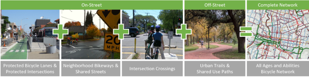
Providing a bicycle system that serves people of all ages and abilities is the most fundamental element to increase bicycle use. The facilities that create this system include an integrated on-street and off-street bicycle network, as well as support facilities such as bicycle parking, showers, and wayfinding.
This Plan identifies five elements of a strong, comprehensive bicycle system:
The Bicycle Network
Strategy 2.1: Create the All Ages and Abilities Bicycle Priority Network Providing a network of safe and comfortable bicycle facilities for people of all ages and abilities is the first step toward encouraging bicycle use. This Plan outlines how the bicycle network and the various facility treatments should be identified, prioritized, designed, and ultimately built. This strategy folds in a prior strategy of addressing network barriers since barriers are a major factor in network project selection.
Integration of Cycling with Transit
Strategy 2.2: Fully Integrate Cycling with Transit Services Bicycling has the potential to significantly improve transit service by providing a solution for the first and last mile. The 2 to 3 mile range of a reasonable bicycle trip, compared to a half-mile walk will significantly increase the potential market for transit. Safe and secure high capacity bicycle parking at key transit stops for regular transit, rapid bus, and rail should be coordinated and implemented. Additionally, bicycle accommodation on all bus, rail transit and van pool vehicles should be provided.
Bike Share System
Strategy 2.3: Maintain and Expand the Bike Share System Modern bike share systems are one of the most catalytic tools cities have to significantly increase bike trips. Bike share systems also add value to the mobility market by providing low cost, on demand, non-ownership based transportation. Because bike share is non-ownership based it broadens the audience for bicycling. Bike share is a great solution to meet short trip mobility demand within the operating area of the system.
E-bikes, scooters, and other micromobility services
Strategy 2.4: Support and manage e-bikes, scooters, and other micromobility devices and services
These devices and services have the potential to help support plan goals but need management to not create unintended consequences that undermine all ages and abilities bicycle facilities and the quality of the pedestrian network.
End-of-Trip Facilities
Strategy 2.5: Provide Comprehensive End-of-Trip Facilities Support facilities, such as secure bicycle parking or storage and shower facilities at the end of the trip are tools to better integrate bicycling into our transportation system. Other supporting facilities include wayfinding and signage along the route to help guide bicyclists to their destination. Providing these items promotes bicycling as easy and convenient for transportation and recreation.
Bicycle Facility Maintenance
Strategy 2.5: Provide Excellent Bicycle Facility Maintenance Maintenance of the bicycle network and supporting facilities will ensure a comfortable and predictable bicycle trip. Bicycles are more sensitive to pavement irregularities and road debris than vehicles due to thin tires and lack of suspension. Roadway features that cause minor discomfort to motorists, such as potholes and improper drain grates, can cause serious problems for cyclists. New equipment, such as narrow street sweepers, are necessary to effectively maintain the physically protected bicycle network.
EVALUATION OF EXISTING BICYCLE INFRASTRUCTURE
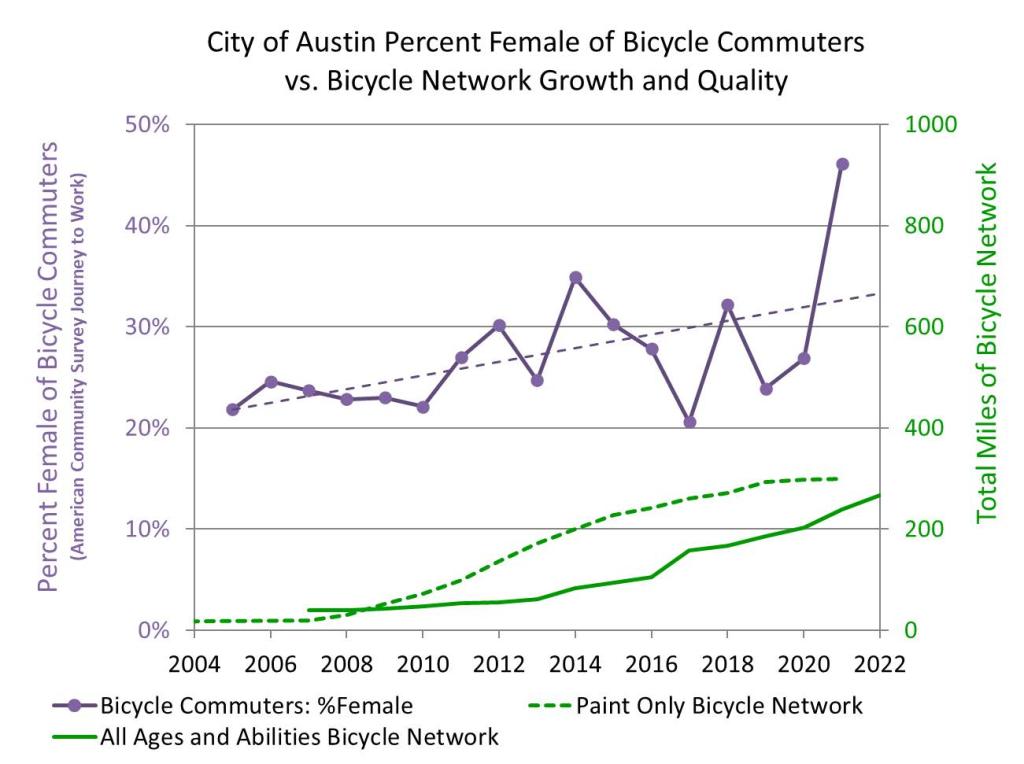 Since the adoption of the 2014 Plan, the Austin region has seen a significant expansion of the bicycle network. Recently network expansion has been almost entirely all ages and abilities bicycle quality bicycle facilities.
In June of 2021, the All Ages and Abilities (AAA) Bicycle Priority Network celebrated a significant milestone of hitting the 2014 Plan milestone of 50% of the original network mileage completed. As of the time of this Plan, the completed AAA Bicycle Priority Network is 258 miles and tracking closely to 2014 network buildout goals (see up-to-date chart of progress towards goal). Over 100 miles of the network are in active development. Over 16 protected intersections have been installed with many more in design.
While the All Ages and Abilities Bicycle Priority Network has significantly expanded it is fragmented and lacks city-wide coverage.
A common best practice indicator of a high-quality bicycle network is when the % share of female riders matches the population. Less comfortable networks result in higher shares of male ridership. The chart above shows how the share of female ridership has changed over time with the improved quality of the bicycle network, Particularly the buildout of the All Ages and Abilities Bicycle Priority Network. While this data is only available through the census for trips to work it is an indicator that the quality of Austin’s network is steadily improving.
Austin’s bike share system has also seen significant expansion since 2014. In July 2020 management of the system was taken over by Capital Metro and rebranded MetroBike.
THE BICYCLE NETWORK
Strategy 2.1: Create an All Ages and Abilities Bicycle Network
The lack of streets that safely and comfortably accommodate people on bikes of all ages and abilities is frequently cited as the top barrier to bicycling in Austin. If Austin is going to embrace the full potential of bicycles as a mode of transportation, serious efforts to implement a robust bicycle network will be necessary.
BICYCLE NETWORK PLANNING BEST PRACTICES
Cities and countries that are industrialized and have access to motor vehicles and have more than 20 % bicycle trip share have one thing in common: connected bicycle networks that accommodate people on bikes of all ages and abilities. Where networks of these facilities are implemented and where there are high levels of short trips, significant mode shift will result. The following is an overview of the planning principles behind the current best practices to achieve significant ridership and benefits to the City.
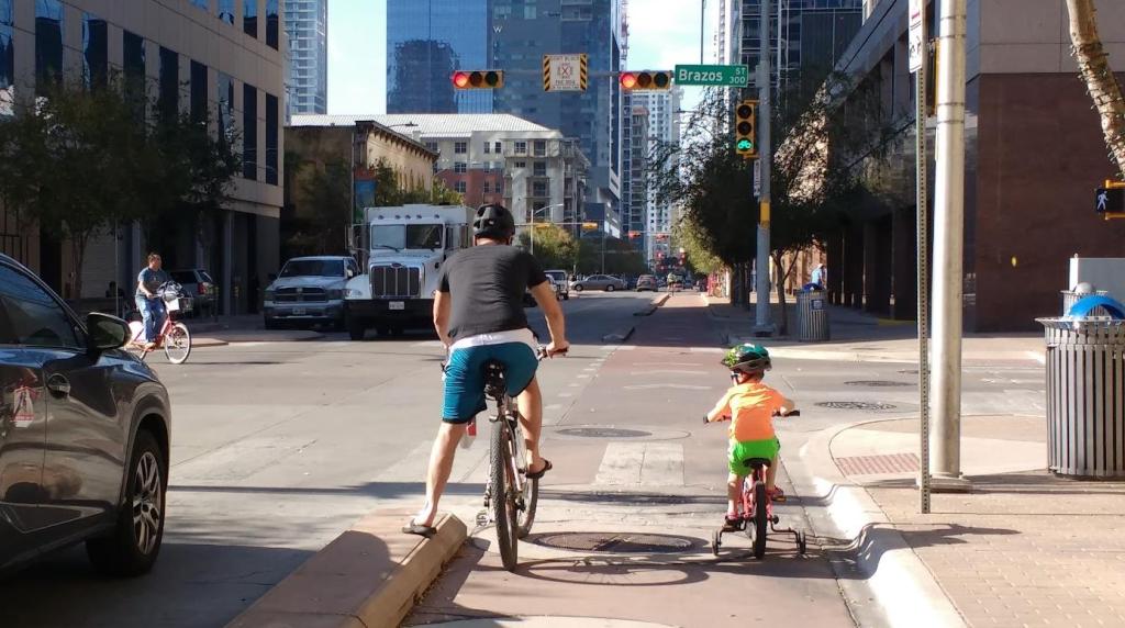
DESIGNING FOR ALL AGES AND ABILITIES
A framework developed by Roger Geller classifies four types of bicyclists in any given population by the level of traffic stress that they are willing to tolerate when considering making a trip by bicycle. The four categories are the “Strong and Fearless”, “Enthused and Confident”, “Interested but Concerned”, and “No Way No How”, which help us understand the portion of the population that would bicycle on protected bicycle lanes, urban trails, and neighborhood bikeways vs who would bicycle in older style unprotected paint-only bicycle lanes.
Geller’s framework was later studied by Portland State University researcher Jennifer Dill, whose work ultimately supported Geller’s findings. As part of the prior 2014 Bicycle Plan, the City of Austin conducted a statistically significant and demographically representative phone survey to determine the portion of Austin’s residents that falls into each category. The survey showed the City’s all ages and abilities approach attracts 55% to 60% of the population, significantly more than older paint only bike lane approaches (It is important to note people who were unhoused and often use bicycles and bicycles to carry heavy loads who did not have access to a phone were not accounted for in this study).
The data from Austin is consistent with proportions in other cities. One trend that was noted was that in cities that bicycling is more widespread with more safe bicycle facilities, the portion of “No Way No How“ is lower (in Portland State’s study of Portland it was 30%) and the “Interested but Concerned” portion was higher. Given the widespread development of a high-quality bicycle network in Austin over the last 10 years we would expect that new data would show closer to 70% of people who would bicycle for some trips if all ages and abilities facilities were present.
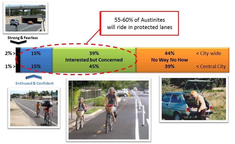
DESIGNING WITH A SAFE SYSTEMS APPROACH
In the US there has been a growing Vision Zero movement that uses a Safe Systems Approach modeled on international best practices. Austin’s Vision Zero Program has been instrumental in implementing this approach in every aspect of how we manage our mobility system.
According to the Vision Zero Network, the Safe System approach is human-centered and proactive.
Key Principles:
- People Make Mistakes - So, our transportation system should be designed and operated to accommodate inevitable mistakes and to avoid death and severe injuries.
- People Are Vulnerable - Human bodies have limits for tolerating crash forces,
so we should design and operate our transportation system to recognize and accommodate human vulnerabilities. - Safety is Proactive - Strategies should proactively identify and mitigate risks in the transportation system, rather than waiting for crashes to occur before reacting.
The Vision Network has implemented numerous projects using this approach and more recently strong partnerships between Bikeway and Vision Zero infrastructure work have aligned to achieve better outcomes.
BICYCLE NETWORK TOOLBOX
To provide a safe, all ages and abilities bicycle network, the following bicycle facility types must be connected to complete a cohesive network: protected bicycle lanes and protected intersections along major streets, urban trails, and neighborhood bikeways coupled with safe crossings of streets. The following descriptions provide an overview of these tools.
PROTECTED BICYCLE LANES AND PROTECTED INTERSECTIONS
Protected bicycle lanes have different forms, but all share common elements—they provide space that is intended to be exclusively or primarily used for bicycles and scooters and are separated from motor vehicle travel lanes, parking lanes, and sidewalks. In situations where on-street parking is allowed, protected bicycle lanes are typically located to the curb-side of the parking.
Protected bicycle lanes may be one-way or two-way, and may be at street level, at sidewalk level, or at an intermediate height. If at sidewalk level, a curb and buffer space separate the bike lane from motor vehicle traffic, while a non-walkable element such as a small curb or planting area separates the protected bicycle lane from the sidewalk. Raised protected bicycle lanes are now the standard for new non-residential streets in Austin per the Transportation Criteria Manual. If at street level, they can be separated from motor traffic by concrete curbs, on-street parking, flex posts, or other physical barriers. By separating cyclists from motor vehicle traffic and pedestrian traffic, protected bicycle lanes can offer a much higher level of comfort and safety than older painted only bike lanes and are attractive to a wider spectrum of the public. For more information on protected bicycle lanes (a.k.a. cycle tracks) see NACTO’s Urban Bikeway Design guidance.
Protected intersections are an intersection design to maintain high quality physical protection for bicycles and a safer design approach for all modes. At a protected intersection the bicycle lane bends slightly away from the vehicles lanes to create shorter pedestrian crossings of the street, building in space for reaction and error, putting people crossing by foot in an advanced stop position for people bicycling, and facilitating two stage turning movements without entering vehicle lanes. For more information on protected intersections visit www.protectedintersection.com and NACTO’s guidance on protected intersections. For more information on how protected bicycle lanes and intersections will be used in Austin view the Components of the AAA Bicycle Priority Network section below. As with all signalized intersections it is important to have detection and signal timing that works well for all modes.
URBAN TRAILS AND SHARED USE PATHS
Urban Trails and shared use paths in general are paths physically separated from motorized vehicular traffic by an open space or barrier and are located either within the road right-of-way, within an independent right-of-way, or accommodated in another way, such as parkland. They are shared by multiple users including, but not limited to, pedestrians, skaters, wheelchair users and bicyclists. For all weather operation, most trails will have a smooth hard surface. Urban Trails are defined and designed by the Urban Trails Plan. For more information on how urban trails and shared use paths will be used view the components of the AAA Bicycle Priority Network section below.
NEIGHBORHOOD BIKEWAYS & SHARED STREETS
Neighborhood bikeways, otherwise known as bicycle boulevards, are streets with low motorized traffic volumes and speeds that are designated and designed to give bicycle travel priority. Bicycle boulevards use signs, pavement markings, and speed and volume management measures (e.g., speed humps and traffic diverters) to discourage through trips and higher speeds by motor vehicles and create safe, convenient bicycle crossings of busy arterial streets. Neighborhood Bikeways make it comfortable to travel by bike in a street by achieving a 20 MPH motor vehicle speed target and motor vehicle volumes between 500 and 1000 vehicles per day. More details on Neighborhood Bikeway Performance Criteria can be found in section Bicycle Facility Type Selection Criteria and more information on neighborhood bikeways visit NACTO’s Bikeway Design Guidance.
Shared Streets is a new tool that will be employed by the Sidewalk, Pedestrian Crossing and Shared Streets Plan to increase the comfort of walking in neighborhood streets as a more cost effective and faster to implement solution where building a sidewalk is not necessary to create comfortable walking conditions. A Shared Street aims for 10 MPH to make walking in a street comfortable due to the very low motor vehicle target speed and speed management infrastructure used, it is important to limit the concept to approximately a few blocks to not create excessive driver frustration that erodes the comfort for people walking. While neighborhood bikeways may be miles long, Shared Streets can complement Neighborhood Bikeways by being in short sections along a Neighborhood Bikeway route and act as a soft motor vehicle traffic diverter or even be coupled with a hard diverter to change motor vehicle access patterns. Coupling the two concepts would help address walkability and could broaden the appeal of the infrastructure changes that require tradeoffs in through access for motor vehicle in favor of more walkable and bikeable local streets while still providing local motor vehicle access.
For more information on how neighborhood bikeways and shared streets will be used view the components of the AAA Bicycle Priority Network section below.
INTERSECTION CROSSING TREATMENTS
For the crossing of major street barriers in the low-stress network, intersection treatments can be used to make the crossings safer and more comfortable. Tools include, but are not limited to bicycle signals, hybrid beacons that give indication to cyclists, median refuge islands, two-way protected bicycle lane connections at offset intersections, and intersection crossing markings. For more information see NACTO’s guidance on Median Refuge Islands, warning beacons, and hybrid beacons for bicycle routes. For more information on how intersection crossing treatments will be used view the components of the AAA Bicycle Priority Network section below.
PLANNING, DESIGN, AND BEST PRACTICE RESOURCES
The City of Austin uses the best and latest available versions of national and international design guidance to inform bicycle infrastructure planning, design, and best practice resources including but not limited to the following resources.
City of Austin Transportation Criteria Manual and supporting standard details – Austin adopted an updated Transportation Criteria Manual (TCM) in 2022 for the first time in 25 years that incorporated best practices from documents below and goals in Imagine Austin Comprehensive Plan and the Austin Strategic Mobility Plan. The TCM makes designing for all modes and all ages and abilities the norm, including protected bicycle lanes and intersections on all new streets and retrofit of street in Austin. Standard details that support the implementation of the updated TCM are in development. 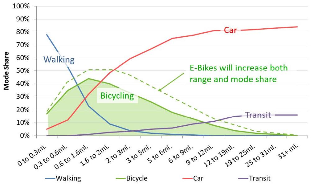
National Association of City Transportation Official’s (NACTO) Urban Bikeway Design Guide (Designing for All Ages and Abilities and Don’t Give Up at the Intersection), Urban Streets Design Guide, Transit Street Design Guide, Urban Street Stormwater Guide, and other guidance and white papers – NACTO has provided the leading bikeway and urban street guidance for Urban Streets in North America since 2010. In August of 2011, the Austin City Council passed a resolution in support of the NACTO guide for bikeway design in Austin. In August 2013, the Federal Highway Administration endorsed the use of the NACTO Urban Bikeway Design Guide. The City of Austin incorporated the NACTO Urban Bikeway Design Guide as a reference in its Transportation Criteria Manual in April 2014 and had a large influence in the fully updated Transportation Criteria Manual of 2022.
CROW Design Manual for Bicycle Traffic – This is the Dutch national guidance on best practices for bicycle planning and design and is a resource in Austin for guidance not yet incorporated in national guidance.
Association of State Highway and Transportation Official’s (AASHTO) Guide for the Development of Bicycle Facilities – At the time of this plan the most recent version was updated in 2011 but there is a new version under development. While the 2011 guide does not capture all the best practices of the above guides and criteria manuals there is useful information for the design of shared use paths. The updated information should incorporate many new national best practices over the last 10 years.
CAPTURING SHORT TRIPS
Because bicycling, like walking, is a human-powered form of transportation, it is inherent that there is a finite amount of energy, time, and as a result distance that a person will typically expend to make a trip. The primary result of this fact is a practical limit on typical bicycle trip lengths. E-bikes both expand the range and increase the potential mode share at any given trip distance. The figure to the right shows mode splits between walking, bicycling, transit, and vehicle use at a range of trip distances.
The majority of very short trips are made by walking, while longer trips are made by vehicle or transit. One very important note about this data is that the trends shown can only be obtained from a place where there are very safe walking, bicycling, transit, and automobile networks. If this data were collected in a place with an unsafe bicycle and walking network (no sidewalks or bicycle lanes), you would see a very different trend that reflects a bias towards motor vehicle trips across all trip lengths. In many U.S. cities, it is common that even short trips are taken by automobile for this very reason. Data shown above is nationwide Dutch travel data including both urban and rural areas. An approximation of the effect of E-bikes was added to the actual data. There is a range of trip distances where the bicycle is the preferred mode of travel because it has a greater range than walking and is faster and more flexible than car or transit for many shorter trips.
During Austin’s Think Bike event in 2012 where Dutch design and policy experts conducted a 3-day workshop and audit of Austin’s bicycle planning, Dutch experts stressed the importance of capturing short trips. First, they showed the data regarding modal patterns by distance. Then they stressed that to achieve a maximum increase in bicycle mode shift, a network of all ages and abilities bicycle facilities should be targeted in areas with the highest concentrations of short trips. They also demonstrated how to use Austin’s regional origin and destination data from the Capital Area Metropolitan Planning Organization air quality model to map out short trips. The data showed concentrations of short trips in the denser parts of Austin where there are better mixes of land uses as seen in the figure below.
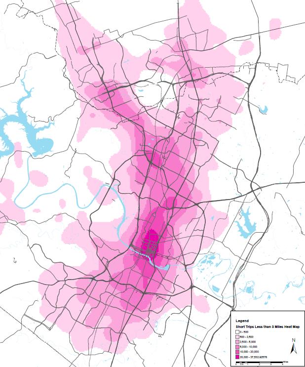
Dutch experts also stressed the importance of capturing short trips around high-capacity transit stations, which due to the results of the funding of the Project Connect proposal in 2020 we now know where these commuter rail, light rail, rapid and frequent bus, and commuter bus stations will be. This provides an opportunity to serve longer trips through linking transit trips with a bicycle trips.
In some areas hilly terrain may also be a significant factor towards energy limits of the rider. Whether to overcome adverse terrain or to increase trip distances, or carry heavier loads on cargo bikes, electric-assisted bicycles are increasingly seen as a supplementary tool to increase acceptable trip distance and bicycle mode share.
FEEDING TRANSIT
As discussed in the introduction feeding transit is a focus area of this planning effort, particularly with the $7.5 billion funding of the Project Connect System Plan. Integrating with and feeding transit is discussed more in the section Integration with the Transit System later in this chapter.
BUILDING A COMPLETE BICYCLE NETWORK
There is an international focus on the importance of complete networks that serve people of all ages and abilities. Quickly building a complete all ages and abilities bicycle network is a powerful tool to serve travel demand, create mode shift, and get the benefits from reduced driving. This was a core strategy of the 2014 Bicycle Plan and significant funding was received in the 2016, 2018, and 2020 Mobility Bonds.
Cities such as Bogota, Columbia; Shanghai, China; New York City, United States; Vancouver, Canada; New York and Seattle, United States; Seville, Spain; Seoul, Korea and many others are looking beyond individual projects or painted bike lane approaches and investing in complete all ages and abilities bicycle networks. International experience has shown that building complete all ages and abilities bicycle networks coupled with large scale public bike share systems can create near overnight changes in travel behavior.
BICYCLE NETWORK DESIGN PRINCIPLES, NETWORK PERFORMANCE CRITERIA, AND FACILITY CRITERIA
To achieve the goal of creating an all ages and abilities priority network, the following design principles, network performance criteria, and facility criteria should be applied.
BICYCLE NETWORK DESIGN PRINCIPLES
Five design principles are used by the Dutch to create a high-quality bicycle network. If any one of these five elements is not adequately addressed the street or bicycle facility should be reevaluated for improvement.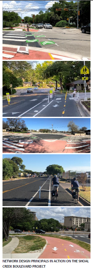
- Cohesion - The bicycle network shall be a cohesive whole with complete routes that are easily understandable. Colored pavement, wayfinding, intersection markings, and other treatments will be used to provide intuitive guidance to cyclists.
- Directness - As mode choice is primarily made on a time-competitive basis, every effort shall be taken to minimize delay for bicyclists in the network and the interface with transit. Safe bicycle facilities on direct routes will be prioritized. Travel efficiencies to minimize time delay are encouraged, including grade separated crossings, green signal waves timed to bicycle speeds and orientation of traffic controls that reduce the number of full stops cyclists must make. Shifts between one-way and two-way bicycle facilities that force unnecessary street crossings should also be limited.
- Safety - Safe conditions are the single largest barrier that keeps people from bicycling. Austin streets shall be made safe for people on bicycles and scooters of all ages and abilities
- Attractiveness - Effort will be made to provide an enjoyable trip that allows users to ride socially (side-by-side), separated from the stress of traffic, and in built environments that are human-scaled, hospitable, and include green elements such as plantings and trees.
- Comfort - The comfort of the user experience will be maximized by providing adequate separation from traffic; minimizing flow interruptions; and providing smooth surfaces, shade, and comprehensibility, along routes.
NETWORK PERFORMANCE CRITERIA
To create a high-quality bicycle network, the following performance criteria will be adhered to.
NETWORK DENSITY
The goal will be to provide a bicycle network density that meets an all ages and abilities quality standard with routes spaced every half to quarter of a mile. This will provide acceptable access to residences, schools, recreational destinations, businesses, and employment. This spacing provides a distance to the nearest bicycle route that provides convenient access without long detours.
In built up areas this density should be applied approximately in a gridded pattern and using the higher ¼ mile spacing in higher density areas. Around major transit stations, transit-oriented developments and Imagine Austin centers, network density is applied radially to provide access to surrounding areas.
Austin is dominated by suburban development patterns with separate land uses and a largely disconnected street network that is dependent on arterial roadways. The Imagine Austin Plan calls for compact and connected development patterns including complete streets with smaller interconnected blocks. At time of redevelopment, even if new connectivity is not made, at minimum, bicycle and pedestrian connections should be made.
DESIGNING FOR ALL AGES AND ABILITIES
In alignment with Austin’s Complete Streets Policy and best practices, all bicycle facilities will be held to the “8-80” test, aimed at creating a network in which both 8-year-olds and 80-year-olds can move about safely and enjoyably.
Austin’s low-stress network will be designed to perform at a level that accommodates the “Interested but Concerned” portion of the population that tolerates a Level of Traffic Stress 2 (LTS2) (See Chapter 2, Best Practices in Bicycle Network Planning, Building a Complete Bicycle Network to read more about low stress bicycle networks and LTS categories). Where possible, the network will be enhanced to accommodate children by providing a Level of Traffic Stress 1 (LTS1).
To meet these goals Austin designs All Ages and Abilities bicycle infrastructure utilizing national, international, and local best practices and design standards. More information on guidance documents can be found in the Design Resources section in this Chapter.
ALL AGES AND ABILITIES DESIGN PARAMETERS
Bicycle planning and design must be done from the point of view of the person bicycling. Designs must account for differences in age, gender, physical abilities, bicycle types, and reasons for cycling. The following are the parameters that will be used in the design of Austin’s bicycle network:
Design Person
Austin’s bicycle network will be designed for people of all ages and all abilities (see section Designing for All Ages and Abilities).
Design Bicycle
Designs shall accommodate bicycles, scooters, cargo bikes, tricycles, hand cycles, trailers, trail-a-bikes, tandems, pedicabs, and e-bikes.
Design Speed
The design speed of the network will generally be optimized for a commuter cyclist traveling 18 mph (preferred – 72’ centerline radius) and 15 MPH (minimum – 50’ centerline radius), which factors in speeds of e-bikes and e-scooters. In certain contexts, for non-through routes (e.g., intersection turning movement design), design speeds as low as 7 MPH can be used (11’ centerline radius).
Design Width
The width of bicycle facilities is important for the safety, comfort, operation, and maintenance of bicycle facilities. Bicycle facilities should be designed to allow passing, side-by-side riding unless there are significant constraints. Bicycle facilities should also be wide enough to be swept by Austin’s street sweeping fleet which includes several small sweepers for protected bicycle lanes. Extra width provides additional capacity for the facility as bicycle traffic does not necessarily flow in a single file like a motor vehicle lane.
The recommended width for one-way protected bicycle lane is 7-8 feet with 3-4’ buffers from motor vehicle traffic depending on street level per the Transportation Criteria Manual section 2.7.1.3 - “Level 2, 3, and 4 Street Design” which also gives values for constrained dimensions. The recommended width for two-way protected bicycles lane is 12’ feet with a typical minimum of 10’ for constrained locations. If high bicycle volumes are anticipated, even in a decade(s)-long horizon, serious consideration should be given to wider facilities.
Minimum width and other standards from American Association of State Highway and Transportation Officials (AASHTO) shall be adhered to for Shared Use Paths to ensure ease of use and safety.
Bicycle Facility Clear Envelope
The design speed and width combine to form a clear envelope for the safe and comfortable operation of bicycles and scooters. Utility poles and other obstructions shall not intrude on this clear envelope and should either be navigated around or relocated as needed.
Separation Between Pedestrian and Bicycle Facilities
Bicycle and Pedestrian facilities should remain separated using protected bicycle lanes, protected intersections, or dual track trails. This supports higher bicycle and walking use levels and reduces conflict between these user groups that travel at different speeds. It is only appropriate to combine bicycle and pedestrian use into a shared use path where current and future use is expected to be low, or design constraints are present that this is the only viable way to separate bicycle users from motor vehicle traffic. Bicycle and pedestrian users are permitted to be mixed in Shared Street environments designed to have very low motor vehicle speed and volume.
Signal Crossing Time
Crossing timings for people on bikes and scooters shall account for inexperienced riders, children, and the elderly.
Signalization at intersections
Intersection signalization at both full signals and pedestrian hybrid beacons should be safe, comfortable, and minimize delay for people bicycling and walking. This includes using low cycle lengths, leading bicycle and pedestrian intervals, providing adequate crossing time, detection that works and signal timing that is responsive to detection.
Intersection Design
The default intersection design in Austin is the Protected Intersection per the Transportation Criteria Manual.
If turn volumes warrant a right turn lane the protected intersection should be designed to accommodate a leading bicycle and pedestrian interval followed by a flashing yellow arrow for right turning vehicle traffic. If a sharp intersection angle and control vehicle movement necessitates separating the right turn movement, it shall be designed as a smart right (raised crossing preferred) as opposed to a free-flowing slip lane. If smart right turn lanes are used, care must be taken that appropriate bicycle and pedestrian facility geometry is used as part of the design which may affect ROW needs.
On-street Parking Design
Vehicular maneuvers in and out of parking spaces should not conflict with bicycle facilities as it creates a hazard to people riding in the bicycle lane. All parking should be designed as floating parking, where the parking is in-between the vehicle lane and bicycle lane, so vehicle maneuvers are outside of the bicycle facility.
The default parking configuration should be parallel parking since it provides better visibility between people riding bicycles and scooters and drivers. While parallel parking is preferred, where diagonal parking is necessary, back-in angle parking shall be used because of improved safety for all roadway users. Older street designs that have angle parking maneuvers that conflict with unprotected bicycle lanes should be retrofitted with parallel floating parking.
Traffic Calming and Bike Lane Design
When motor vehicle traffic calming elements are used in combination with bicycle lanes and protected bicycle lanes, care should be taken to not degrade the quality of adjacent bicycle facility. Speed bumps and humps should be places in a way that they affect the motor vehicle lanes but not the bicycle lanes as they can be a hazard to people on bikes and scooters, particularly in low light conditions. Traffic chicanes should also be design in such a way that motor vehicle traffic is horizontally deflected while the bicycle facility can proceed straight. This prevents inappropriate and unsafe motor vehicle encroachment into bicycle facilities.
BICYCLE FACILITY TYPE SELECTION CRITERIA BY MOTOR VEHICLE SPEED, VOLUME AND CONTEXTUAL FACTORS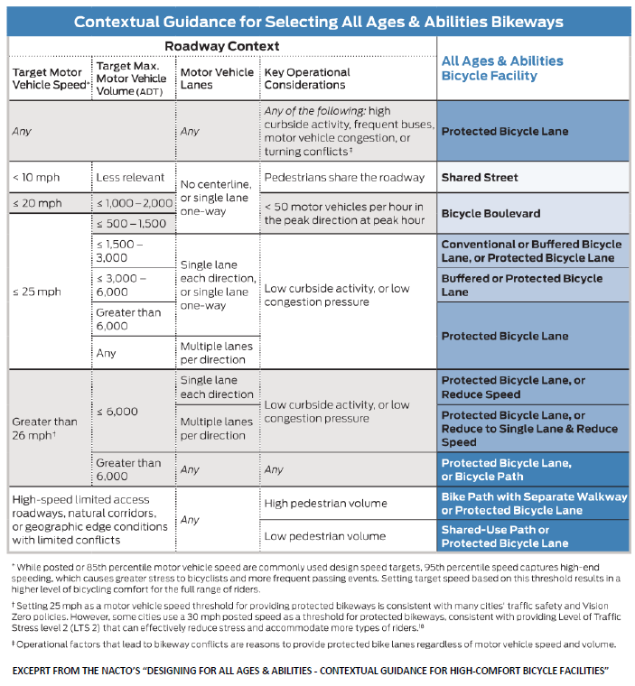
The selection of the appropriate bicycle facility type along a given roadway that meets all ages and abilities level of quality depends on many factors including motor vehicle speed and volume as well as other contextual factors. Austin uses guidance and criteria found in NACTO’s “Designing for All Ages & Abilities - Contextual Guidance for High-Comfort Bicycle Facilities” which aligns national and international best practices. This guidance was used as the foundation to the 2022 rewrite of Austin’s Transportation Criteria Manual (TCM) that governs new and rebuilt streets. In short, the TCM requires protected bicycle lanes on all non-local
streets defined in the TCM as street levels 2 -5 which includes traditional collector, arterial, and highway street types. Streets with higher motor vehicle speed, volume and other contextual factors that reduce comfort and safety require the use of Protected bicycle lanes and trails to achieve safe and comfortable conditions for all ages and abilities.
- Higher motor vehicle speeds have a significant effect on the severity of crashes.
- Higher motor vehicle speeds and volumes reduce comfort, increase risk of crashes, and increase noise.
In addition to speed and volume criteria for physical protection, neighborhood bikeways (a.k.a. bicycle boulevards), and Shared Streets, special consideration will be given to other factors including but not limited to curbside activity, on-street double parking pressures, parking frequency, delivery activity, multiple travel lanes, transit service, and route continuity such as completing gaps in off-street urban trails or safe routes to schools. The chart below shows NACTO’s contextual guidance for selection all ages and abilities bicycle infrastructure that this plan adopts
THE BICYCLE PRIORITY NETWORK VS. COMPLETE BICYCLE FACILITY RECOMENDATIONS (ALL STREETS)
The long-term goal of this plan and Austin’s Complete Street Policy is to ensure all streets in Austin are accessible by all modes including bicycling for people of all ages and abilities. This would require physically protected bicycle lanes (or in some contexts shared use paths) on all busy streets which would take many decades and billions of dollars to achieve. The only way to create an all ages and abilities bicycle network in Austin within a short-term time frame is to use a combination of bicycle facility types where opportunities exist to form a cohesive network. The Plan recommends an All Ages and Abilities Bicycle Priority Network that will guide strategic public investment and capture the benefits that bicycling can bring as criteria for facility selection. The chart gives criteria for streets to be considered shared streets, neighborhood bikeways to Austin in the near term.
The planning recommendations for the creation of a bicycle network suitable for people on bicycles of all ages and abilities are thus twofold:
- Complete Bicycle Facility Recommendations (All Streets): The Austin Strategic Mobility Plan (ASMP) has bicycle facility recommendations for all streets (see ASMP for maps and tables) to meet Austin’s Complete Street Policy that shall be followed when there are opportunities to build or reconfigure a roadway. The Transportation Criteria Manual (TCM) gives more specific direction on how new streets and street reconstructions are designed (section 2.8.0 details typical cross sections). Both the ASMP and TCM require that all new streets except low volume local streets have protected bicycle lanes (street levels 2- 5) and local streets (street level 1) are required to have speed management. More information on the complete recommendations can be found in the Complete Bicycle Facility Recommendations section below.
- All Ages and Abilities Bicycle Priority Network (AAA Bicycle Priority Network): The purpose of the AAA Bicycle Priority Network is that it could be reasonably funded and constructed within the next 5-10 years. Projects that were included in this network were deemed to be compatible with existing traffic volumes, on-street parking demands and construction/feasibility. The short-term network was strategically cost optimized to deliver the highest public value for the investment and the realization of a connected network not just individual projects. More information on the AAA Bicycle Priority Network can be found later in this chapter in the section The All Ages and Abilities Bicycle Priority Network.
Additional sections address other important aspects of creating a complete bicycle network including removing on-street parking in existing bicycle lanes and how to handle the unique needs and opportunities along TxDOT-managed roadways.
COMPLETE BICYCLE FACILITY RECOMMENDATIONS (ALL STREETS)
Unlike the subset of recommendations in the AAA Bicycle Priority Network, the Complete Recommendations are not limited by near-term feasibility. The recommendations documented in the Austin Strategic Mobility Plan (ASMP) maps and tables would result in streets safe for people of all ages and abilities. To be realized, these recommendations will often require reconstruction of streets or new streets to be built. The Transportation Criteria Manual (TCM) gives more specific direction on how new streets and street reconstructions are designed (section 2.8.0 details typical cross sections). Both the ASMP and TCM require that all new streets except low volume local street have protected bicycle lanes (street levels 2-5) and local streets (street level 1) are required to have speed management. Other factors that could result in a higher quality recommendation could be Safe Routes to School, Urban Trail or All Ages and Abilities Bicycle Priority Network Plan recommendations; special approaches for bicycle facilities in TxDOT rights of way; or detailed study of a street or corridor. The full recommendations also encompass the recommendations for the All Ages and Abilities Bicycle Priority Network.
Because the existing network often provides only limited mobility for bicyclists and the complete streets policy goal is to accommodate people of all ages and abilities on all streets, the deletion of any roadway from the network should be done with the utmost care and only if alternative facilities can be provided.
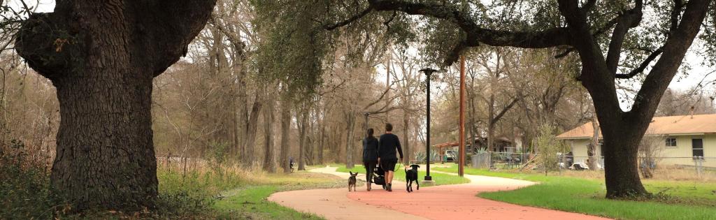
THE ALL AGES AND ABILITIES BICYCLE PRIORITY NETWORK (AAA BICYCLE PRIORITY NETWORK)
This section gives details on the All Ages and Abilities Bicycle Priority Network, the types of trips it serves, the prioritization model for project selection, how quick implementation and final quality will be balanced, as well as cost and benefit of the network.
COMPONENTS OF THE AAA BICYCLE PRIORITY NETWORK
This section covers Austin’s strategy in using each of the following bicycle infrastructure components to quickly and cost effectively form a safe, comfortable, and cohesive all ages and abilities network.
PROTECTED BICYCLE LANES AND PROTECTED INTERSECTIONS
In Austin, the default new street design includes protected bicycle lanes and protected intersections. As part of nearterm
AAA Bicycle Priority Network implementation, many streets will be able to be cost effectively converted to
protected bicycle lanes (learn more in toolbox section above) within existing curb lines or in the right of way without major reconstruction. Protected bicycle lanes and intersections will also be created with large capital projects where resources are available or as new private developments occur. The following are strategies to use this tool in Austin to create a low stress network:
- Provide protected bicycle lanes where current street space allows on streets that meet speed and volume criteria and other contextual factors.
- Use protected bicycle lanes to connect urban trails and bicycle boulevards to form a cohesive all ages and abilities bicycle network. Where these connections are not possible due to constraints, the connection should be made with bicycle lanes or other appropriate facilities, so the network remains connected and cohesive.
- Leverage new development and capital projects to implement protected bicycle lanes and protected intersections per the Transportation Criteria Manual.
Existing painted only bicycle lanes do not generally count as part of the AAA Bicycle Network. In some cases, wide buffered bicycle lanes on lower speed and volume
streets can meet criteria for All Ages and Abilities quality. While legacy painted bicycle lanes still have value the City prioritizes achieving All Ages and Abilities quality on all new projects.
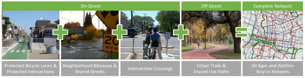
URBAN TRAILS AND SHARED USE PATHS
Austin has an expanding network of urban trails (learn more in toolbox section above), though potential corridors are often fragmented and do not follow travel desire lines as well as shared use paths along TxDOT roadways and controlled access highways (see TxDOT section below).
An Urban Trail Plan is being updated in parallel with the 2023 Bicycle Plan through the ATX Walk Bike Roll process. The Urban Trails Plan will include recommendations for a comprehensive network of urban trails and develop prioritization for potential trails. This plan looks at urban trails as a tool to supplement on-street connections. Potential urban trails are acknowledged in the long-term recommendations in this plan. Trails included in the Urban Trails Plan are acknowledged in the All Ages and Abilities Bicycle Priority Network. Shared use paths should only be used where pedestrian densities and conflicts are expected to be low. If pedestrian densities are medium or higher separate protected bicycle lanes and sidewalks should be used and protected intersection designs at intersections. Wider paths should be used when there is more anticipated use.
The following are strategies to use urban trails and shared use paths in Austin to create an all ages and abilities priority network:
- Connect urban trails using protected bicycle lanes and bicycle boulevards to create a cohesive low-stress network.
- Partner with other programs such as urban trails program, sidewalk program, and safe routes to school to build trail connections that address gaps in the onstreet bicycle network or limited connectivity that creates longer bicycle and walking travel distances.
- Improve cohesion of on-street and offstreet networks by making transitions between on-street and off-street urban trails seamless. This includes design that brings urban trails to intersect directly with streets and makes street crossings safe; provides trail-head treatments that are highly visible, consistent, easily recognizable; and includes wayfinding signage along the urban trails.
- Design trails with transportation cyclists in mind as recommended in the Urban Trails Plan. This includes providing hard, smooth surfaces and separate trails for pedestrians and wheeled users (bicyclists, rollerbladers, skateboarders, mobility impaired, etc.) where space allows. This will create a safer and more accessible trail system for all users.
- Due to the significant cost and time required to develop hard paved trails (currently $3-6 million a mile) consider phased strategies and community partnerships for trail development that start with natural surface or decomposed granite trails or singletracks that create transportation connections sooner along public land and easements and allow starting to manage tree growth along the corridor. For more information see section Phased Strategies for New Trail Connectivity.
- Shared use path design should adhere to best practices latest version of the AASHTO Guide for the Development of Bicycle Facilities and the Transportation Criteria Manual.
NEIGHBORHOOD BIKEWAYS AND SHARED STREETS
Much of Austin lacks the comprehensive grid street network that creates ideal conditions for Neighborhood Bikeways (learn more in toolbox section above), also known also as Bicycle Boulevards. In Austin, based on predominately suburban era development patterns, collector streets (ASMP level 2 streets) are often the lowest street classification that has significant connectivity though newer development code requires connections of local streets that can be good candidates for neighborhood bikeways. Because of the lack of local street connectivity, the use of neighborhood bikeways will largely be limited to making connections between other low-stress facility types on streets that are not critical to the motor vehicle network or planned into new development patterns. Often, these neighborhood bikeway routes are obstructed by major street crossings and physical barriers such as creeks and hills. These barriers will have to be overcome for neighborhood bikeways to provide useful connections to the All Ages and Abilities Bicycle Priority Network.
The following are strategies to use this tool in Austin:
- Evaluate opportunities for neighborhood bikeways where there is a street grid that offers redundancy and best practice speed and volume performance targets can be achieved (through motor vehicle speed management and diversion infrastructure).
- Use neighborhood bikeways to provide connections to urban trails and protected bicycle lanes to form an all ages and abilities priority network.
- Connect neighborhood bikeways across barriers to create contiguous routes.
- Create local street connections or bicycle and pedestrian only connections as part of new developments to create useable neighborhood bikeway routes on local streets.
- Ensure that all neighborhood bikeways meet stringent national best practice performance requirements. Assess existing Neighborhood Bikeways; if performance requirements are not met make necessary changes.
- Ensure that Neighborhood Bikeways have adequate lighting, particularly in locations with speed management devices.
The City of Austin Watershed Protection Department is always searching for opportunities to reduce impervious cover and add green infrastructure, while increasing comfort and safety for pedestrians and bicyclists. This is an excellent opportunity to combine multidepartment City strategies to save money and deliver higher value to the public.
The Speed Management Program priorities can also be leveraged along desired neighborhood bikeway routes to meet both program goals and pool resources.
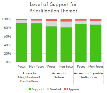 INTERSECTION CROSSING TREATMENTS
Intersection crossing treatments (learn more in toolbox section above) should be used to cross barriers created by busy streets to connect protected bicycle lanes, neighborhood bikeways, shared streets, Urban Trails, and shared use paths into a connected network where people can safety travel between communities and neighborhoods.
PRIORITIZATION THEMES FOR THE AAA BICYCLE PRIORITY NETWORK
In this Bicycle Plan update the AAA Bicycle Priority Network was expanded around three themes shared between Bicycle and Urban Trails Plans that emerged through the ATX Walk Bike Roll process: access to neighborhood destinations, access to nature, and access to city-wide destinations.
The 2014 Bicycle Plan was more focused on creating a basic city-wide all ages and abilities bicycle network that would make bicycling a viable and safe choice since at that time the network was badly fragmented and very few bicycle trips were possible at an all ages and abilities level of quality. While connections to local destinations such as schools, parks, and transit stations and connections to nature through parks and trails were acknowledged they were not the focus of the last planning effort. Many previous efforts were executed with more of a focus on recreation instead of utility. Thus, many of the users have been recreational cyclists instead of commuters. Additionally, a more utilitarian approach will ensure bicycle safety at all times of day. Many service workers are unable to afford a vehicle, and service jobs end their shifts at night. A more robust bicycle network would mean more consistent usage throughout the day and night, instead of simply during traditional commuting hours.
This plan update acknowledges a shift to the three themes above to better capture the variety of trips that people want and need to take as well as being responsive to the travel needs within individual communities as displacement and affordability pressures continue to change where people live and who can take what trips by which mode for what purpose.
Each of these three themes received strong support from stakeholders in the ATX Walk Bike Roll planning process from both focus populations and non-focus populations. The summary of results was that all three themes received over 80% support from both groups (focus and non-focus) with access to neighborhood destinations with the most support, followed by access to city-wide destinations and then access to nature. The 2014 Plan also focused on capturing short trips which continues to be an important planning principle though the application of this is adapted to each of these three themes.
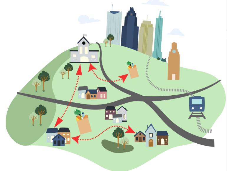
ACCESS TO NEIGHBORHOOD DESTINATIONS
This theme is oriented to providing access to destinations such as local schools, parks, libraries, corner stores, commercial areas
such as neighborhood centers and corridors. This theme aligns well with the 15-minute city and Equitable Transit Oriented Development planning concept covered in the introduction where societal needs should be available within 15 walk or bike ride. One exciting opportunity with this theme is for our mobility and land use systems to co-evolve. Focusing bicycle
networks at a neighborhood scale could help support the development and vitality of diverse neighborhood destinations in a way that reduces dependence on motor vehicle trips and associated land patterns such as over parking and regulations such as minimum parking requirements. Bicycle networks on a neighborhood scale could also help foster an increase in social interactions and improve community health.
School Access
One important local destination is to provide safe walking and bicycle access to schools. This gives opportunities for improved physical activity, mental wellbeing, and improved safety near the school. One of the significant barriers to bicycling to school is traffic generated by the high volume of families that drive their children to school. Left unchecked, traffic volumes and driving habits create a vicious cycle that causes more and more families to feel uncomfortable letting their kids walk or bicycle to school. To break this cycle, safe all ages and abilities infrastructure for walking and bicycling like protected bicycle lanes and trails need to be provided. Motor vehicle management strategies should also be considered such as park and walk strategies and no stopping zones. It is also important that strategies for motor vehicle management such as one-way streets allow two-way use of streets by people walking and riding bikes. It is also critical to take care in the placement of new schools such that there are not barriers for young children to walk and bicycle to the school.
If the school’s placement is such that some barriers do exist, they should be addressed with infrastructure or school boundary changes as part of the planning and construction of the school. Austin has a well-funded Safe Routes to School Program with significant infrastructure funding working to make it safe to walk and bike to school. This plan update included all Safe Routes to School Infrastructure recommendations in the AAA Bicycle Priority Network and Bikeway Program resources can be available to partner on projects meet both program needs and address bigger infrastructure challenges.
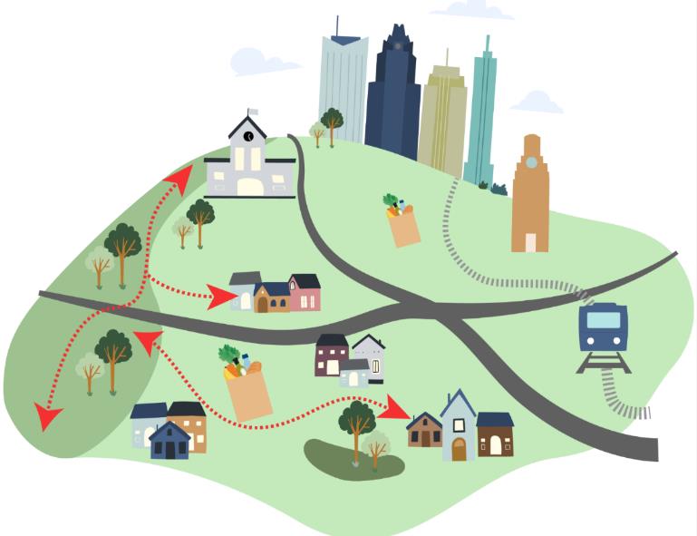
Access to Nature
This theme is oriented to connecting people with nature and bring nature into the city which is the two-pronged guiding principle in the Imagine Austin Comprehensive Plan.
“AUSTIN IS A HISTORICAL RACIALLY SEGREGATED SPACE, WHICH INCLUDES THE ACCESS OR LACK THEREOF TO GREEN SPACES. BLACK AND LATINX COMMUNITIES ARE OVERWHELMINGLY EXCLUDED FROM “ENJOYING” THESE AMENITIES IN THE CITY. IT’S EVIDENT FROM A SIMPLE RIDE IN HISTORIC BLACK AND LATINX PREDOMINANT COMMUNITIES. THE ADDITION OF BIKE LANES AND IMPROVEMENTS OF TRAILS IN THESE NEIGHBORHOODS DIDN’T COME ABOUT UNTIL GENTRIFICATION TO ACCOMMODATE THE NEWER WHITE RESIDENTS. IT’S EVIDENT.”
Parks, open spaces, and street right-of-way are the City’s biggest public spaces, and this theme works towards the possibility of seamlessly integrating these systems. Streets could become trail-like with bike lanes and sidewalks separated from motor vehicle traffic by vegetated barriers treating irrigated and treating street stormwater. These pathways along streets could form linear trails along streets to connect parks, natural areas, and urban trails together. More information on vegetated bicycle barriers to create more park-like streets can be found in section on Full Build Quality & Shade and Green Street Infrastructure From the “Our Parks, Our Future” plan’s statistically valid survey: The two most important amenities to residents were multi-purpose and nature trails (57%) and open spaces/nature parks/preserves (42%). Desire for bicycle recreational amenities were also identified in the plan such as BMX / skate parks, pump tracks, mountain bike and single-track trails. From this Plan ten themes emerged from the numerous community engagement events and surveys completed as part of this planning process; five are particularly relevant to this theme:
- NATURAL EXPERIENCES - PEOPLE EXPRESSED A DESIRE FOR PARKS THAT FEEL MORE NATURAL. THIS INCLUDES UNDEVELOPED, WILD NATURAL SPACES; RUSTIC FINISHES INSTEAD OF PAVED AREAS, AND MORE NATIVE PLANTS.
- UNSTRUCTURED SPACES IN GENERAL - PEOPLE CARED LESS ABOUT SPACES FOR SPECIFIC PROGRAMMING, OPTING FOR MORE MULTI-USE SPACES AND PRESERVING GREEN, NATURAL, AND OPEN SPACES.
- GREEN INFRASTRUCTURE - THERE WAS AN INTEREST IN PROACTIVELY USING GREEN INFRASTRUCTURE IN PARKS TO BUILD A MORE RESILIENT CITY. THIS INCLUDES STORMWATER MANAGEMENT, FLOOD PROTECTION, HEAT ISLAND EFFECT MITIGATION, DROUGHT TOLERANCE, AND NATIVE PLANTING/HABITAT AREAS. LINEAR PARKS & TRAILS PEOPLE WERE MORE INTERESTED IN PARKS THAT ALLOW THEM TO MOVE (WALK/RUN/BIKE) AS OPPOSED TO STAYING IN ONE PLACE. THERE WAS AN INTEREST IN NATURE AND MULTI- PURPOSE TRAILS WITHIN PARD PARKS AS WELL AS CONNECTIVITY BETWEEN PARKS ALONG URBAN TRAILS.
- PROXIMITY & ACCESS PEOPLE WERE CONCERNED ABOUT BOTH THE LACK OF PARKS NEAR THEM AND/OR THEIR ABILITY TO GET TO PARKS. THIS INCLUDES ISSUES AROUND WALKABILITY, ADEQUATE PARKING, AND PUBLIC TRANSIT ACCESS.
Safe walking and bicycling pathways to and through parks provide a great way for people to both access and experience these special public spaces without the negative impacts of motor vehicles on these spaces. Robust trail connectivity allows people to experience our parks in a much less invasive way, preserving more of park-land for its intended purpose. Paved trails serve not only people on bicycles but people of all ages and abilities riding razor scooters, roller blades, roller skates, skateboards, wheelchairs, and other wheeled devices. Because these facilities serve such a wide audience and can access areas where motor vehicle access is undesired or infeasible, they have the potential to activate and
connect people with areas deep within parks that are currently underutilized, bring our parks to life.
Within parks and public spaces, purpose suited facilities for mountain biking, cycle across, gravel, youth-oriented bicycle playgrounds, and BMX biking can also be a means of connecting more people to nature through bicycling as well as broaden the audience for taking trips by bicycle. A related opportunity is to better connect and integrate with non-paved trails for both connectivity and recreation. This is discussed more in section Phased Strategies for New Trail Connections.
This theme also supports a nation-wide initiative that Austin is a part of called Cities Connecting Children to Nature that seeks to create more equitable and abundant access to nature.
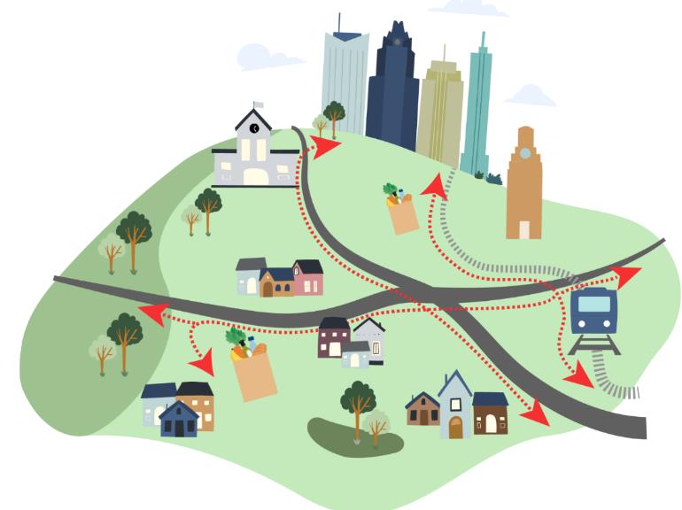
ACCESS TO CITY-WIDE DESTINATIONS
This theme is oriented to providing connections beyond the neighborhood scale throughout the city. While long bicycle trips with this theme would be possible the goal would rather be to generally serve short trips by providing safe connections for a variety of trips. This approach was the
focus of the 2014 Bicycle Plan’s efforts to create a basic all ages and abilities city-wide bicycle network since at that time the network was nearly non-existent, and most trips made by bicycle were by people who were confident in more stressful conditions. This theme prioritizes connections to regional employment, regional corridors and centers, district parks, higher education, cultural centers, grocery stores, hospitals and medical complexes and transit stations.
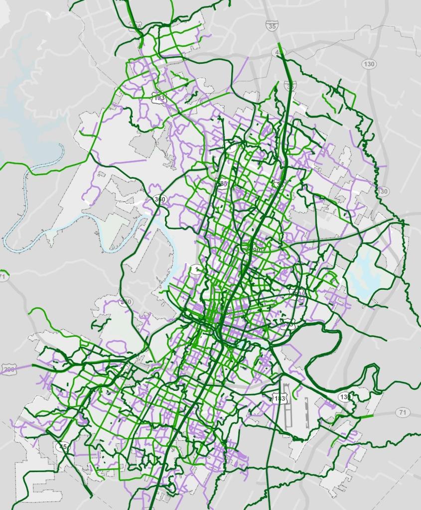 AAA BICYCLE PRIORITY NETWORK RECOMENDATIONS
The All Ages and Abilities Bicycle Priority Network is comprised of a set of facility recommendations on streets developed to deliver the highest cost/benefit on the investment and achieve equitable outcomes.
The map to the right shows a snapshot of the All Ages and Abilities Bicycle Priority Network at time of adoption. This online interactive map of the AAA Bicycle Priority Network is the authoritative living network which is discussed in more detail below. The ATX Walk Bike Roll planning process for this plan update resulted in significant network additions that reflect plan priority areas and public input. Emphasis for additional network coverage was to ensure equity of access and alignment with Project Connect, the Corridor Construction Program, Urban Trial Program priorities, park land acquisition activities by PARD, TxDOT / CTRMA and other major all ages and abilities network connectivity developments. Network additions were also evaluated for alignment with the three prioritization themes for the AAA Bicycle Priority Network: connections to local destinations, connect to nature, and connect to city-wide destinations. Growth in the network between the 2014 Plan and this 2023 Plan can be seen in the chart to the left.
This network is considered a living network and new network opportunities are added as they are identified. Individual projects are prioritized per the approach described in the next section. New network opportunities might include all ages and abilities facilities planned to be built by TxDOT, new private developments, another department, or other agency. New connectivity often results in additional network analysis which could result in identification of additional network opportunities that could become priorities for the city’s Bikeways Infrastructure Program funding.
The City maintains this authoritative interactive online map showing this living AAA Bicycle Priority Network, which is regularly updated with project statuses, expected completion dates, website and more. The chart above shows a summary of the build status of the network. Snapshots of this living network are captured in adoptions of the Austin Strategic Mobility Plan first adopted in 2019, updated in 2022, and was updated again in 2023 simultaneously with the adoption of this Plan.
AAA
Map based public feedback was incorporated into significant expansion in the All Ages and Abilities Bicycle Priority Network as part of the approximately 600 new miles of network added through the ATXWBR planning process. While this information was helpful for identifying new and very valuable connectivity opportunities it became clear that this input had significant issues with engagement bias that did not make it suitable for use in prioritization or systematic network identification which would go against values of the ATXWBR equity framework and equity centered planning. An analysis of the upvoting of different recommended trails through the crowdsourced effort showed no correlation between the value of the idea and the number of upvotes. For example, there were a dozen locations in a highly engaged neighborhood each with around 100 upvotes and other locations underrepresented neighborhoods with no upvotes indicating an opportunity or issue of equal or greater importance. The same is true of the bias in the level of invested time and energy by stakeholders in different communities to identify network opportunities or challenges which again required that the planning team utilize the value of the interactive map feedback while not depending on it for systemic network evaluation or prioritization.
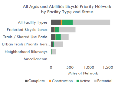
AAA BICYCLE PRIORITY NETWORK BUILDOUT GOALS
The chart to the right shows the City’s progress towards the 2014 Plan AAA Bicycle Priority Network Mileage Goals as well as network mileage goals proposed for this 2023 Plan update. The 2023 Bicycle Plan recommends extending the 2014 Plan network mileage goals and sustaining them for the next 10 years. The chart also includes forecasted network buildout form known project as well as tracking mileage of projects that are under development. The full buildout of the network would result in a significant increase in bicycle use and help the City meet its goals as set out in the Imagine Austin Plan and Austin Strategic Mobility Plan. One way of evaluating the extent of network buildout beyond total mileage is the portion of major streets that can accommodate people of all ages and abilities. Major streets are defined as street levels 2-4 (e.g., collector and arterial streets) as defined by the Austin Strategic Mobility Plan. The following describes what share of major streets will accommodate people of all ages and abilities at different points of AAA Network buildout:
- 13% of major streets currently accommodate people of all ages and abilities.
- After meeting buildout goals, in 10 years 30% of major streets will accommodate people of all ages and abilities.
- At this rate, full buildout would take 26 years and 75% of major streets would accommodate people of all ages and abilities.
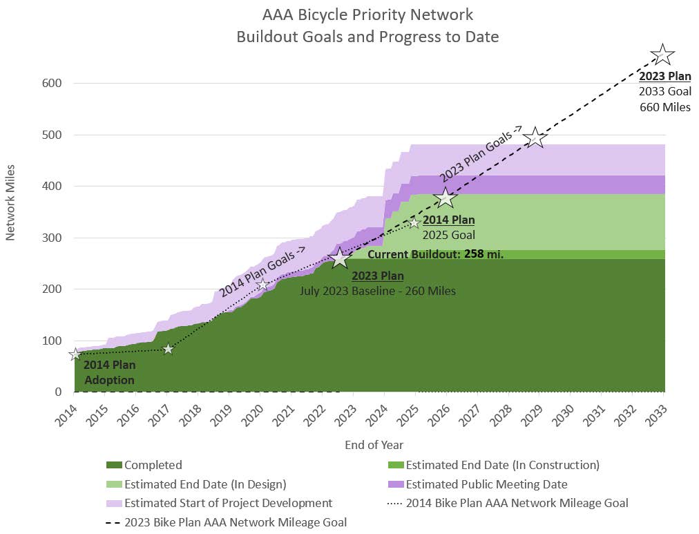
The AAA Bicycle Priority Network will be built largely in a phased approach initially using quick build strategies to quickly create city-wide connectivity and later phases to achieve the full build quality including concrete or planted barriers for bike lane protection, protected intersections, high quality bus stops, shade, lighting, and green infrastructure. Goals for quick build, medium build and full build qualities for the AAA Bicycle Priority Network are discussed in the Phased Approach section.
PRIORITIZATION AND PROJECT SELECTION FOR THE AAA BICYCLE PRIORITY NETWORK
The following section covers project prioritization, project selection, and project delivery for the Bikeways Infrastructure Program.
BIKEWAYS PROGRAM
The Bikeways Program is an infrastructure program to develop and construct bicycle infrastructure aligned with this plan and is currently funded by the 2016 and 2020 Mobility Bonds as well as other miscellaneous funding sources. The 2016 Mobility Bond dedicates $20 million of Local Mobility Bond funding “for bikeways for transportation and mobility purposes.” The target for substantial completion of the 2016 Mobility Bond Bikeways Program is eight years through 2024.
The 2020 Active Transportation and Safety Bond dedicated an additional $40 million to this program to
be implemented in six years starting in 2022 through 2027. These time frames balance demand for rapid implementation while allowing sufficient time for project development and public process, as well as
identifying cost-saving leveraging and coordination opportunities.
PROJECT PRIORITIZATION
Through this planning process a new prioritization model has been developed to guide use of city Bikeway funds from the 2016, 2020, and any subsequent City of Austin Mobility Bonds. For the first time the Bikeways Infrastructure Program is using a data driven Graphic Information System (GIS) based analysis method to provide a starting place for the selection of projects for further development. While this model, or any model, cannot be a perfect reflection of complex systems and factors it should provide a useful data driven basis that reduces human biases and blind spots from the project selection process. The project selection process is discussed later in this section that accounts for other nuanced factors the model cannot address such as localized connectivity needs, coordination opportunities, supportive programming, feasibility, outcomes of public engagement and finer grained cost assessments.
This model attempts to support the three prioritization themes that were jointly developed by Bikeways and Urban Trails through this planning process: Access to Neighborhood Destinations, Access to Nature, and Access to City-wide Destinations. This model attempts a balanced approach to these three themes as each received strong support from focus and non-focus populations as discussed in the prior section Prioritization Themes for the AAA Bicycle Priority Network. In general priorities will be based on more on people traveling for transportation and utility as opposed to people traveling for sport or recreation.
The table shows the weights applied to the prioritization model grouped by category.
-
Equity - The first group of factors relate to equity giving priority to communities that have historic underinvestment, low income, low vehicle ownership, and poor health outcomes. While these demographic factors can often corelate with community vulnerability and concerns with gentrification, it can also be important for individuals who may or may not have access to a motor vehicle to have the choice to make trips by bicycle, scooters, or motorized wheelchairs in safe bicycle infrastructure to access opportunity (jobs & transit), to reduce household costs, have the opportunity for safe physical activity.
Through the plan’s equity centered public engagement, particularly through feedback received through the community ambassadors from focus communities, there were two predominant sentiments expressed that relate to active transportation project prioritization that are in tension without easy solutions to address holistically.
The two sentiments were:
- People wanted the same things that privileged communities get, good parks, safe streets, sidewalks, and trails.
- That these potential positive changes to their neighborhood won’t benefit them if they can’t afford to live there anymore. While changes in the quality of neighborhoods (e.g., park, walkability, bike ability improvements) have some effect on localized housing prices, issues with housing prices, affordability, and displacement are much larger and deeper rooted than infrastructure and public space improvements. This equity centered planning effort resulted in the understanding that mobility professionals, advocates, and policy makers cannot work in silos and need to fully engage in advocacy and planning around a holistic approach that integrates affordability, anti displacement, land planning, multi mobility, transit, and other disciplines. More on these issues and strategies can be found in Chapter 1 Introduction, sections The Two Central Challenges and New Focus Areas.
- Destinations & Travel Demand – The second group of factors relate to what drives travel demand. They provide a data-driven basis to understand how a particular project serves access to neighborhood and city-wide destinations, jobs (including low income jobs), residential density, connections to parks, and transit. A major focus of this plan update is how to integrate transit and bicycle systems, particularly considering the funding of the initial phase of the Project Connect system plan. The transit factors, analysis methods and weights align to strategies opportunities articulated later in this chapter in the section Integration with the Transit System, namely using bicycles to feed transit.
- Connectivity & Safety – The third group of factors relate to the existing and planned safety and connectivity for people getting around on bicycles and scooters captured in the current state of the All Ages and Abilities Bicycle Priority Network. The barrier score gives weight to projects that cross barriers such as highways, waterways, and railroads. The street level (street levels are defined in the Austin Strategic Mobility Plan – see the Street Network Map) score gives weight to harsher street environments with higher motor vehicle volumes and speeds. Crashes are not used because they are not a reliable indicator of unsafe conditions where people are not comfortable riding a bicycle. Instead, the lack of a robust all ages and abilities bicycle network is used as the indicator of unsafe conditions. Existing unprotected paint only bicycle lanes that do not serve people of all ages and abilities do not affect the prioritization. Opportunities to upgrade existing substandard facilities or install new all ages and abilities facilities are treated the same.
- Cost – The last category is cost, which is a significant factor by which streets and connections get selected to be improved by the City’s Bikeways Infrastructure Program. The top infrastructure goal of this this plan and program is to quickly develop an All Ages and Abilities Bicycle Priority Network that equitably serves travel
demand and gives people mobility choices. To do this at a city-wide scale requires using cost effective quick build approaches and improving quality over time which is why cost is included as a factor. Many projects make more efficient use of street space, repurposing existing pavement to provide the space needed for safe conditions for people on bicycles and scooters. In some cases, pavement space is not available and higher cost approaches like building shared use paths are necessary. These higher cost projects are selected when other prioritization factors are high and there are no lower cost alternatives to meeting connectivity deficiency.
By including cost, it is important to be clear that this prioritization model is not solely a need-based
prioritization but rather a tool for selection of projects for the Bikeways Program funded by city mobility bonds that factors in planning level estimates of project cost.
Other programs and agencies (e.g., the Corridor Program, Substandard Street Program, Project Connect, and TxDOT / CTRMA and other programs) also partner in the buildout of the all ages and abilities bicycle network often by constructing high cost improvements often in areas that would be consider high need but beyond cost intensities and construction complexity that the Bikeways Infrastructure Program is able to take on.

This prioritization model is intended to be a living framework that is updated and refined regularly. The model is built in a GIS tool that can be easily rerun and updated with new datasets (e.g., updated demographics and latest network buildout) or improved methods (e.g., routing an analysis that responds to connectivity and barriers rather than crow flies, accounting for the dynamics of demographic changes). These refinements could introduce new factors or refine weights given to different factors. Current model results can be explored in the All Ages and Abilities Bicycle Priority Network online tool.
PROJECT SELECTION
Prioritization and project selection for the Bikeways Program is handled differently for prioritized and coordination projects. The mix of project types will be balanced depending on the degree of opportunities in each category and resources available to implement each year. Projects selected for development are published and have opportunities for public feedback through the Mobility Annual Plan Process.
Prioritized Projects - Prioritized project selection will begin with high and very-high priorities resulting from the project prioritization discussed above. High priority project candidates will be further screened at a high level for feasibility, detailed connectivity considerations, street slopes, ability to address barriers along routes, opportunity for supportive programming, cost benefit of the project, and coordination opportunities. From this screening new projects would emerge that would become part of the broader Bikeways Program project portfolio for further development including public engagement for projects that have significant tradeoffs. Many projects that are initiated as prioritized Bikeway Program projects ultimately become coordination projects as other mobility programs are engaged on how to work together to broaden outcomes through the project.
Coordinated Projects - Projects that have a coordinated implementation opportunity often capture synergies, broaden project outcomes, streamline delivery and result in reduced implementation cost, and thus will often be prioritized for implementation. Selection of these projects is based on the project prioritization while accounting for the value of the coordination opportunity. Coordination projects often leverage street resurfacing work, named projects and other program partners’ efforts.
“WE NEED ACCESSIBLE MEETINGS FOR INTERESTED PARTIES AT ALL DIFFERENT HOURS OF THE DAY, SO THAT PEOPLE IN DIFFERENT CAREER FIELDS CAN ATTEND AND MAKE THEIR VOICE HEARD. NOT EVERYONE IS IN A 9-5 OR HAVE WEEKENDS OPEN.”
PROJECT DEVELOPMENT AND PUBLIC ENGAGEMENT
Several factors could potentially affect the development and delivery of a project, including further feasibility study & design, the results of public engagement, and coordination needs. For projects that require choices to determine the best balance of potential changes within the right-of-way given competing interests, robust public engagement is used as part of the project development. The purpose of this process is to have a trust building conversation with public stakeholders about the choices at hand and what the effect and outcome of these choices are to determine the best use and configuration of the public right-of-way and alignment with City policy goals.
Through this process, the no build scenario is always an option presented also as a choice to maintain the status quo. It is critical to ensure that public engagement is equitable, accessible, and understands the needs of local communities. Special effort will be made to avoid historically exclusionary tactics based on time constraints for civic engagement. Tools to support equitable and accessible engagement can include providing translated project materials, interpretation at public meetings, having a wider variety of engagement opportunities than evening meetings or online public engagement that meet people where they are, conducting additional meetings to move at the speed of trust, having community ambassador support for project-based engagement, and other best practice approaches.
The project development timeline for bikeways projects varies significantly. Most projects take between six months to two years from start to end, including feasibility analysis, design, public process, and implementation. Depending on complexity and coordination dependencies, this can take up to several years or as quickly as a few months.
All projects take a complete streets approach and often make improvements to pedestrian safety, transit support and motor vehicle operations through a variety of tools and approaches. This flexible approach is at
the heart of delivering a large-scale program of projects that are successful at building out a connected bicycle network while balancing other mobility or community needs.
The evaluation of projects and programmatic approaches can take many forms. As standard practice, the City monitors and adjusts as necessary to all mobility systems and projects. In some cases, before and after studies are conducted to better understand a particular project or broader programmatic approaches which can be a useful tool to further build public trust.
A PHASED APPROACH: QUICK BUILD VS. FULL BUILD QUALITY
Elements of the AAA Bicycle Priority Network will be built in a phased approach initially using quick build strategies to
quickly create city-wide connectivity for people of all ages and abilities and phased approach to later achieve the full-build quality. This includes upgrading protected bicycle lane barriers to concrete or planted barriers, concrete protected intersections, shade, and green infrastructure. Typically, Neighborhood Bikeways and Trails are built at full-build quality though some elements like additional shade, green streets elements might be phased or upgraded over time.
This plan recommends completing the following bicycle infrastructure at full (and medium) build quality annually (new or upgrade):
- Protected Bicycle Lanes: 5 miles at fullbuild and 5 miles at medium-build quality
- Protected Intersections: 5
- Enhanced bus stops: 10
Additional information on this recommendation can be found in section Cost of the AAA Bicycle Priority Network. Austin utilizes national, international, and local best practices and design standards to design to meet our All Ages and Abilities and 8-80 design goals as discussed in the section Network Performance Criteria, Designing for All Ages and Abilities in this chapter. If any parts of the existing network do not meet these standards and best practices, they will be prioritized for upgrade to meet these standards. Prioritization will consider corridors with high use and other competing priorities to develop new network connectivity.
PROTECTED BICYCLE LANE BARRIERS
The barrier type for a protected bicycle lane is an important element that determines the comfort of a bicycle lane, the time or cost it takes to implement a project, the compatibility to stormwater flow and many other multi-department operational factors shown in the chart below. For the successful implementation of protected bicycle lanes, it is necessary to take context sensitive approaches to providing the barrier, that best balance all needs for the street. To aid in project development the toolbox of barrier types show below has been developed to assist with decision making.
Through this planning process there has been significant feedback to increase the quality of protected bicycle lane barriers beyond common quick build approaches and to even develop fast to implement medium-build tools if there are barriers to full build barrier quality barriers on a particular street.
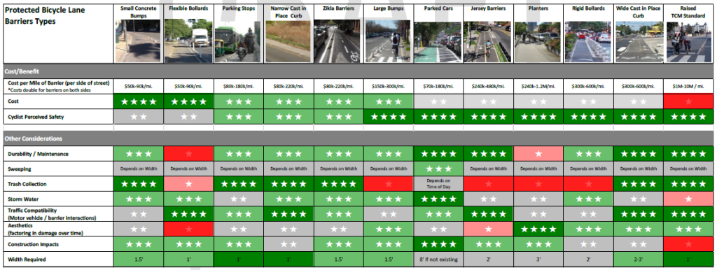
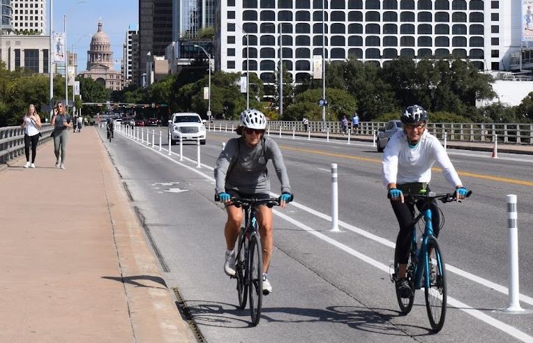
Quick Build Quality
Quick Build Bike Lane Barriers
Most AAA Bicycle Priority Network recommendations would be initially achieved with quick and cost-effective approaches that optimize the existing street space to improve conditions for bicycling, walking, transit users and people driving often using flex posts, concrete buttons. One of the biggest reasons for the use of quick build barriers is that they have negligible impacts to street drainage.
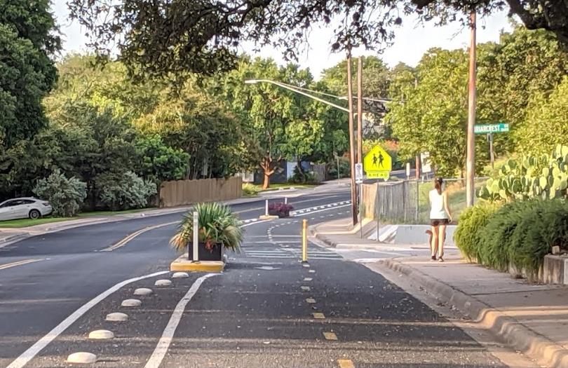
Medium Build Quality
Medium Build Bike Lane Barriers
Medium build techniques that increase bike lane quality while still having negligible impacts to street drainage are an important tool to increase the scale of higher quality network buildout. Medium build techniques could utilize parking stops, larger concrete buttons, or Zikla or other similar barriers, on-street parking, and limited flex posts. This plan establishes a goal to build 5 miles of medium Build protected bicycle lanes a year. Currently Austin only has 2 miles of completed protected bicycle lanes at medium-build quality.
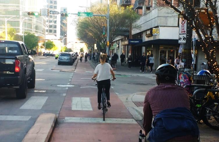 Full Build Quality
Full Build Bike Lane Barriers
Full Build bicycle lane barriers use concrete curbs or planted buffers. This plan establishes a goal to build 5 miles of high-quality full-build protected bicycle lanes a year. Currently Austin only has 12 miles of completed protected bicycle lanes at full build quality completed over the last 8 years, so this goal represents a significant expansion of bicycle lanes of this quality. The Austin Transportation Criteria Manual now calls for new streets to be built with behind curb raised protected bicycle lanes as shown in the top image to the left. The photo on the bottom shows a promising retrofit strategy that uses a raised concrete curb on the motor vehicle side but a planting area that minimizes impacts to street drainage as impacts to street drainage can significantly escalate cost and affect feasibility.
For broader implementation of full build concrete bicycle lane barriers, this plan recommends revision of the Drainage Criteria Manual (DCM) to allow flexibility in DCM requirements to support cost effective and high-quality multimodal safety improvements to existing streets.
PROTECTED INTERSECTIONS
Also per Austin’s Transportation Criteria Manual (sections 3.6.0 and 3.6.1.1) protected intersections are the standard street design. Protected intersections are often built in the quick build phase of projects, both with quick-build paint and post methods or in full-build concrete where there are opportunities or need to reconfigure the space to meet the mobility and safety needs for all modes. If protected intersections are not built in concrete during the quick build phase of implementation, a phased approach would be used to later achieve full build quality. Details on the number of existing quick and full build protected intersections is included in Appendix C: AAA Bicycle Priority Network Details and Cost Estimate.
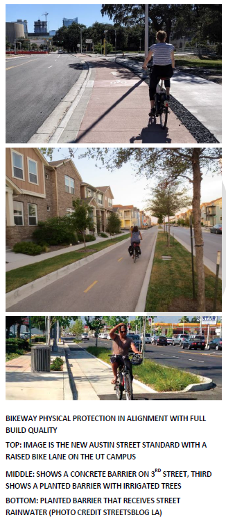 SHADE AND GREEN STREET INFRASTRUCTURE
Per the Imagine Austin principle to integrate nature into the city and the need for shade in support of walking and bicycling infrastructure and to improve outcomes for heat vulnerability; trees, shade, and green street elements will be considered a basic part of active transportation infrastructure. Focus should be given to providing shade at intersections where people must wait to cross streets as well as providing minimum standard of shade coverage or interval along streets. Building green street elements and particularly shade into retrofit projects has been challenging due to limitations in current contracting approaches that require warranting plantings and requiring temporary irrigation. Changing contracting and innovative approaches will likely be necessary to unlock lower cost and easier to implement as a part of projects. The following are action items that support Strategy 2.1: Create the All Ages and Abilities Bicycle Priority Network in this area.
Strategy 2.1 Action Items Supporting Shade and Green Street Infrastructure
2.1.1 Consider trees, shade, and green street elements as a basic part of active transportation infrastructure and work to implement along existing infrastructure and new projects. Relevant action items are also included in Chapter 4 Implementation, section Internal Alignment.
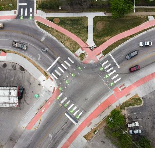
PROTECTED INTERSECTION DESIGN AT PAYTON GIN AND OLHEN
THAT IMPROVES SAFETY AND SHORTENS CROSSING DISTANCES
FOR PEOPLE WALKING AND BICYCLING
2.1.1a Create a jointly funded and administered tree planning program for active transportation programs implemented through partnership with allied departments and divisions (e.g., Tree Mitigation Program / Urban Forestry, Parks, Watershed, Austin Civilian Conservation Corps) that works to shade high need areas and where populations are more vulnerable to heat stress and related illness. This program should be built to work on a large scale and at low costs. Moreover, partnerships with community groups, such as PTOs, will be increased for opportunities for engagement from all ages and abilities.
2.1.1b Explore public private partnerships and innovative approaches to remove barriers to planting at large scale and low cost.
2.1.1c Explore innovative strategies such as constructing vegetated areas and tree zones when new infrastructure is built that naturally gets rainwater during storms as the only irrigation source. Native or adapted plants that will survive and thrive in this type of environment should be used. Explore other possible innovations such as using phased approaches (planting opportunity areas setup with initial construction and planted and developed by others), grow zones / no mow areas that use natural succession, planting saplings at large scales (that are not warrantied) to reduce cost of shade coverage delivered and improve drought resilience.
2.1.1d Work to plant or establish edible fruits and nuts as part of diverse tree plantings (see photos of the volunteer mulberry trees that provide shade and food).
2.1.1e Partner and cost share with Watershed Protection Department to implement rain gardens that treat stormwater for vegetated and tree shade areas where appropriate for improved drought resistance and ecological outcomes.
2.1.1f Provide reclaimed or potable irrigation water for street trees and vegetated areas for publicly funded projects in the ROW without cost or fees (like electricity for street lighting) except for sites that are being privately developed with planting and license agreement requirements
2.1.1g Explore innovative non-piped irrigation methods for planting establishment or drought mitigation where curb lines with planting areas are flooded with reclaimed or hydrant water to reduce cost, complexity, and barriers to implement.
2.1.1h Develop maintenance capacity, data tracking, and training for tree and vegetation maintenance in partnership with internal and external entities and the public at large. Consider partnership with entities such as Austin Civilian Conservation Core, American Youth Works or similar programs and residents along streets to leverage placemaking and community capacity building opportunities.
PHASED STRATEGIES FOR CAPITAL PROJECTS WITH FULL BUILD AT REDEVELOPMENT
When necessary due to limited right-of-way or budget for a capital project a phased approach can be used to initially create all ages and abilities infrastructure and later with redevelopment upgrade it to the full quality called for the Transportation Criteria Manual (TCM). The initial approach which is being used on the South Lamar Corridor and likely Project Connect light rail corridors is to build shared use paths on both sides of a street with the initial capital project. This saves space, possibly right-of-way acquisition, cost and
can be appropriate as an interim strategy if pedestrian and bicycle conflicts are expected to be low or moderate and if the alternative is unprotected bicycle lane or reduced project extents due to budget limitations.
The shared use path would be built meeting all requirements of a protected bicycle lane and a shared-use-path meeting ADA requirements and would later be converted to the protected bicycle lane as site development happens. The shared use path should be colored with the protected bicycle lane integral color. Nearing intersections the shared use path should be split into sidewalks and protected bicycle lanes so that the Full Build protected intersection design can be implemented in the initial phase. At time of site development, the TCM and the commercial design standards will require that shade trees and separate sidewalk are constructed as part of the project. As site development happens, which will generally increase pedestrian and bicycle conflicts more and more of the sidewalk would be separated from the bicycle lane.
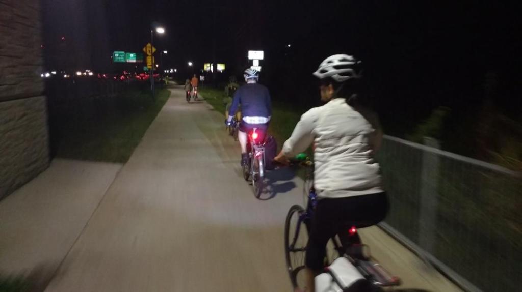 LIGHTING
Improved lighting for intersections, shared use paths, bicycle and pedestrian crossing treatments is another important feature to improve over time and is often not included
in initial quick build approaches.
Current lighting policies and programs also lead to inequities for different modes of travel. Austin Energy currently provides lighting along streets but does not light pathways without cars such as transportation trails in parks and other public spaces (see the Utility Criteria Manual and Austin Energy Lighting Services Website for current street lighting services
provided).
The roots of our moon tower street lighting system in 1894 were public safety driven. It was implemented over a decade before the first production car was in 1908. Over time our lighting policies and standards for streets, which used to have only people walking, bicycling, and on horseback or cart, have become co-opted and generalized in a way that works for either neighborhood streets or for drivers on busier corridors operating motor vehicles with headlights. Current policies and standards fail to address the public safety needs and nuance for safe bicycle and pedestrian (including people accessing transit) user crossings as well as pathways without motor vehicles
(trails).
The current approach requires that trail projects that add lighting to increase costs by adding electric meters and have sponsor departments take on maintenance of the lighting when departments and maintenance groups do not have certified electricians. These barriers often prevent lighting from being included in projects or inefficiently increase costs. It is important that these policies be reassessed so that equitable lighting and safety outcomes for all travel modes can be achieved in an efficient way that makes best use of public resources. Trail and intersection crossing safety lighting should be treated like street lighting: without meters and operated and maintained by Austin Energy. Current lighting standards are also not optimized for safety outcomes such as providing standard lighting for bicycles and pedestrian crossings of streets. The following statistics are from the FHWA Pedestrian Lighting Primer (2022). These statistics are focused on pedestrian safety trends, but they also apply to bicycle safety given that unlike motor vehicles most people bicycling have relatively low levels of lighting and share personal safety concerns of people walking.
- Nationally, 76 percent of pedestrian fatalities in 2019 occurred in dark conditions (NHTSA, 2021).
- New or improved lighting has a nighttime pedestrian Crash Reduction Factor of between 42% – 81%.
- Quality lighting has been shown to increase perceptions of personal safety/security and to lower crime rates.
Innovative lighting strategies could also be explored that reduce initial capital costs and open lighting to pathways that would be unlikely to ever receive lighting. This could include exploration of highly reliable solar powered lighting products that are motion activated, cast light along a linear trail. This type of lighting has the potential to be smaller, lighter, more easily installed, support a darker sky and habitats. The following are action items that are supportive of Strategy 2.1: Create the All Ages and Abilities Bicycle Priority Network in this area.
“[IT] IS VERY DARK TO WALK AT NIGHT MAKING THAT INSECURE FOR THE PEOPLE WHO ARRIVE FROM WORK LATE AND THE ONLY OPTION TO WALK THE DOGS OR EXERCISE IS AT NIGHT. THE SIDEWALKS ARE WIDE ENOUGH TO WALK AND MOVE WITH KIDS AROUND BUT IS VERY NECESSARY TO PUT SOME LIGHTS.”
Strategy 2.1 Action Items Supporting Multimodal Lighting
2.1.2 Austin Energy should provide equitable, efficient, and dark-sky compliant lighting for all modes of travel and safety treatments not just along streets, but also
along urban trails and bicycle & pedestrians street crossings (intersection or midblock) located in right-of-way, easements, parkland, TxDOT right-of-way, and other public lands.
2.1.2a Lighting for trails and crossing safety should not be metered and should be operated and maintained by Austin Energy
2.1.2b Lighting safety standards and approaches for urban trails and crossing safety treatments should be refined based on best practices for public safety outcomes
PROGRAMATIC AND PHASED STRATEGIES FOR NEW TRAIL CONNECTIVITY
This plan also recommends using programmatic and phased strategies for creating new trail connectivity or microconnections for walking and bicycling pathways and improving quality over time. Of particular importance are short trails connections / micro-connections that connect currently disconnected streets and trails. This approach addresses several issues. One is that Urban Trail development costs have risen to $3-6 million a mile. Another is that with city-wide affordability issues people are being displaced to outlying areas that are less connected compared to older and more central parts of Austin, increasing distances that need to be traveled resulting in increased car dependence. The difficult task of improving connectivity, particularly for walking and bicycling will be important in these areas. There is also an opportunity to align with the highest amenity priority in the Parks and Recreation system-wide plan to build trails that connect people to nature discussed in the Prioritization Theme - Access to Nature section. This Plan recommends establishing a Micro- Connectivity Program that is tailored to create this type of connectivity for people who walk, bike, and roll at scale and with dedicated funding, capacity, planning, prioritization, and innovative methods that does not compete with prioritizations for longer Urban Trails or more cost effective on-street Bikeway prioritization.
Such a program or existing programs could use innovative phased strategies to develop new bicycle and pedestrian connectivity:
- Secure public land and easements where connectivity is needed. Special effort will be made to avoid historically exclusionary tactics based on time constraints for civic engagement.
- Do basic trail building work in line with nature trails to make pathways that are passable by walking and bicycling which includes creating a trail alignment that is optimal for grades, respecting environmental features and protected trees, and starting to manage tree growth. Managing tree growth by removing small or invasive trees or pruning to make space for the trail is better done gradually over time. This work could be done by the City or community partners.
- Identify and leverage already established single track trail connectivity. Web applications like Trailforks.com and Open Street Map maintain fairly comprehensive databases of off-street and nature trail development. Create agreements with community partners to improve and maintain quality natural surface trail connectivity in priority areas.
- Over time, improve the trail surface to be more all-weather and more reliably accessible for all users such as decomposed granite, stabilized decomposed granite, or other pavement types that can be implemented with low levels of permitting and cost. As trail quality increases, the City or partners will need to plan for upfront costs but also maintenance costs.
- If desired and funding is available develop into a full quality Urban Trail or paved Shared Use Path
This strategy sets in motion a co-evolution of the trail alignment, tree growth, width, surface, and use where the capital and maintenance needs start very low and increase as higher trail standards are held over time. The following are action items that support of Strategy 2.1: Create the All Ages and Abilities Bicycle Priority Network in this area.
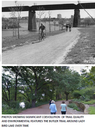
Strategy 2.1 Action Items Supporting Programmatic and Phased Approaches to Establish New Trail Micro-Connections
2.1.3 Use programmatic approaches to develop new trail-based connectivity for people walking, bicycling, and rolling at scale.
2.1.3a Establish a micro-connectivity program that focuses on creating new trail-based connections for bicycling and walking. The unique nature of micro-connections that create new connectivity and shorter and safer pathways for people to walk, bike and roll warrant having a dedicated programmatic effort with dedicated funding, capacity, planning, prioritization, and innovative methods that does not compete with prioritizations for longer Urban Trails or more cost effective on-street Bikeway prioritization.
2.1.3b Use innovative phased approaches to create new and needed bicycle and pedestrian connectivity focusing first on public access and low-cost trail improvements and later investing to upgrade quality over time.
2.1.3c Partner with community partners to establish and shape trails over time. other active transportation programs to create new connectivity in areas that have limited connectivity.
2.1.3d Partner with other active transportation programs (including Urban Trails, Safe Routes to School, Sidewalks) and departments (including Parks and Recreation Department) to create new connectivity in areas that have limited connectivity including land or easement acquisition.
2.1.3e Utilize best practices for quality and sustainable singletrack trails including the International Mountain Bicycling Association's (IMBA) Guide to Building Sweet Singletrack, Bike Parks: IMBA's Guide to New School Trails, Guidelines for a Quality Trail Experience.
BICYCLE NETWORK IMPLEMENTATION STRATEGIES
The following are common strategies to implement bicycle facilities within constrained retrofit environments.
NARROWING EXISTING MOTOR VEHICLE LANES
Existing motor vehicle lane widths are often wider than necessary to provide for safe operations. This extra space can be allocated to other uses and travel modes, including bicycle facilities without adverse impact on motor vehicle operations. Most retrofit projects use 10’ wide vehicle lanes (and in some cases narrower) to make space for protected bicycle lanes, sidewalks that need street space, pedestrian crossing islands and transit stations.
LANE CONVERSIONS
Lane conversion projects are a powerful tool to optimize motor vehicle lane configuration for better safety and mobility outcomes including making space for safe walking, bicycling, and pedestrian crossing facilities. These projects are done with careful data collection and analysis. Lane conversions have other benefits beyond improving the bicycling safety and comfort of a street. According to the Road Diet Handbook: Setting Trends for Livable Streets, “the resulting benefits [of a road diet] include reduced vehicle speeds; improved mobility and access; reduced collisions and injuries; and improved livability and quality of life” (Rosales, 2006, p. 3). A City of Austin 2104 report on lane conversion projects in Austin found that crashes reduced by 25-40%, high risk speeding decreased by 90%, and resulted in significant increases in bicycle volumes over
time.
The City of Austin has successfully completed lane conversion in over 70 projects and 50 miles of streets throughout Austin including Pleasant Valley over Longhorn Dam, Teri Road, Woodward St., Shoal Creek Blvd, Stassney Lane, St. Johns Avenue, and Congress Avenue.
PARKING MODIFICATION
A roadway’s primary functions are to provide mobility and to serve as great public places, storing stationary vehicles is tertiary. Additionally, parking is often underutilized and street underorganized which gives the opportunity to consolidate parking along a street to make space for safe places for people to walk, bike, and cross the street.
While on-street parking is an often desired and useful component on urban roadways, it can be dangerous to bicyclists. When a vehicle parks in a bicycle lane, it creates a dangerous situation requiring people on bicycles to merge into a traffic lane to get around the vehicle. Therefore, parking shall not be permitted in bicycle lanes.
The Transportation and Public Works Department will evaluate existing and proposed bike facilities, to determine, with stakeholder input, if parking or bicycle facilities have greatest priority. To the extent possible, the evaluation of parking in bicycle lanes should be considered on a corridor basis and not block-by-block. In 2008, the City established guidelines to address removing parking from within bicycle lanes. This document, On-Street Parking Modification Guidelines, discusses research, the evaluation of and process for modifying on-street parking resulting in several possible outcomes. Since 2008, this process has been used successfully on 115+ projects and 80+ miles of bicycle lanes.
Today there are only a few miles of legacy bicycle lanes that have parking conflicts remaining. These should be addressed shortly coupled with a city-wide ordinance that prohibits parking in all bicycle lanes. This will reduce parking signage needs and sign clutter and makes educating the public easier, and behavior more consistent.
STREET RECONSTRUCTION
Street reconstruction projects are an opportunity to reuse the space within the rights of way through a rebuild of the street in whole or part. While these projects are
very expensive and few and far between, they present the most flexible opportunity to make the street complete, including providing bicycle facilities that are safe for people of all ages and abilities.
INCORPORATING BICYCLE FACILITIES WITH ALL PROJECTS
Incorporating accommodations for bicycles in new public and private development projects greatly increases the chances for better quality bicycle infrastructure. Accommodating bicycles after construction often requires costly retrofitting, sometimes resulting in a non-standard and inferior design solution. To create this network, bicycle facilities shall be included in all reconstruction of arterials and collectors in already developed areas of Austin and all new roadway construction in areas under development (City of Austin, 2002, City Council Resolution #20020418- 40.). Additionally complete streets that serve all modes and people of all ages and abilities should be included in all projects and phases (City of Austin, 2014, Complete Streets Policy). Because roadways are often built in phases, this Plan requires the interim version of all new or improved roadways also include adequate bicycle access, as approved by the Transportation and Public Works Department. Designing the facilities in coordination with those who maintain them can reduce expensive maintenance in the future and assure a design which will better assure the intended use. Inconsistency across construction documents presents a challenge to providing uniform quality in bicycle facilities. Some design standards are unique to the authority involved. Other standards, handicapped access for example, are applied to all projects by federal regulation.
COST OF THE AAA BICYCLE PRIORITY NETWORK
The AAA Bicycle Priority Network updated through this planning effort has grown to over 1,200 miles of protected bicycle lanes, neighborhood bikeways and shared use
paths, plus over 300 miles of Urban Trails (existing + priority tiers 1-3). Approximately 250 miles of this combined network are complete, and 150 miles are already planned and funded for construction by multiple jurisdictions.
Excluding the Urban Trails Network and portions funded by other entities, the cost of the approximately 800 miles of remaining unfunded network has a planning level cost of $1.15 billion.
This planning level cost estimate assumes high-quality levels of buildout as seen on recent projects like Teri Lane and Shoal Creek Boulevard, which use a mix of quick build techniques on segments and full-build protected intersections in concrete. This estimate does not include projects funded by other jurisdictions like TxDOT and CTRMA as part of larger regional projects, private developers, or other entities. It is notable that protected bicycle lanes and neighborhood bikeways make up 74% of the network mileage yet only 32% of the cost of $370 million. Trails and Shared Use Paths, which include bridges and underpasses make up 23% of the network mileage but account for 68% of the cost of $783 million due to the higher cost per mile.
The project prioritization for bikeway funds includes a cost factor so projects that have a lower cost per mile will be elevated in priority as one of many other factors (Equity, Destinations and Travel Demand, Connectivity and Safety). More detail can be found in Chapter 2 Bikeway System, section Project Prioritization. The Plan also includes goals for AAA Bicycle Priority Network Buildout at Full-Build quality (see Chapter 2, section A Phased Approach: Quick Build vs. Full Build Quality). To increase quality of the network this plan sets full-build quality goals of 5 miles of concrete protected bicycle lanes, 5 protected intersections, and 10 high quality bus stops plus a goal of 5 miles of medium-build protected bicycle lanes with an additional estimated annual cost $14 million per year.
More information on the network and full build quality cost estimates can be found in Appendix C: AAA Bicycle Priority Network Cost Details and Cost Estimate.
The following sections will look at the community wide benefits we can expect from this investment through increased bicycle and decreased motor vehicle use.
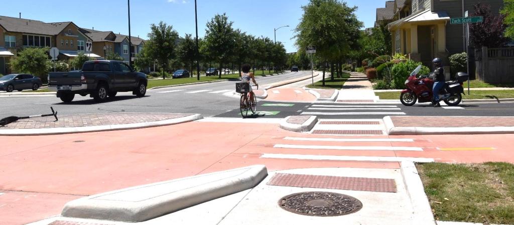
QUANTIFYING INCREASE IN BICYCLE USE
The first step in quantifying benefits of bicycling to the City and region is to estimate the increase in bicycle use. The 2014 Bicycle Plan conducted an analysis that was a significant step forward in our abilities to quantify both the magnitude and areas where this behavior change is likely to occur. As discussed in the best practices section, existing short (to medium length for e-bikes and scooter) trips are the most likely candidates to be converted to bicycle trips and network investments should be targeted in these areas.
This plan update sets the following attainable short trips capture targets for areas where existing travel demand is served by the all-ages and abilities network investment. An analysis conducted in 2014 estimated reduction in number of motor vehicle trips and miles traveled are based on the full build-out of the All Ages and Abilities Bicycle Priority Network at that time.
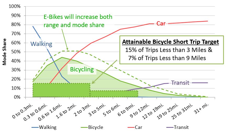
The bicycle trip capture targets were then applied to the Metropolitan Planning Organization’s origin and destination matrix used for the air quality model. The origin and destination data describes the mobility demand from 1,400 traffic analysis zones to each of the other 1,400 traffic analysis zones by the number of trips between each zone. With this data travel demand that is served by the All Ages and Abilities Bicycle Priority network can be determined. Where this demand is served by the network, the trip capture targets are applied to calculate the resulting increase in bicycle trips and corollary reduction in motor vehicle trips. The trip capture targets are well below known possible limits obtained from Dutch national data shown in the chart above. The trip capture targets for Austin’s urbanized area were set at approximately one-third of the level of bicycle use found across the entire Dutch nation including both their urban and non-urban areas. The origin and destination travel data used for Austin is from 2010. Future increased infill in the central Austin and around transit stations should result in the availability of more short trips. The transition to more mixed use development patterns should also result in shorter trip length patterns.
COST/BENEFITS OF THE AAA BICYCLE PRIORITY NETWORK
Another significant advancement of the 2014 Bicycle Plan was the application of trip capture targets for the purposes of quantifying the benefits of the full build-out of the recommended All Ages and Abilities Bicycle Priority Network investment to the City of Austin. The proceeding section describes the methods used to forecast increased bicycle use, and the corollary reduction in motor vehicle use. The estimated changes in mode from motor vehicle to bicycle were then applied to estimate the benefits of other measurable outcomes.
As demonstrated by the analysis from 2014 below, the recommended All Ages and Abilities Bicycle Priority Network investment should be considered an investment of regional reach and scale as the benefits are on the order of magnitude of other regional investments being made to address the issues, and directly forward the goals of Imagine Austin.
Benefit to Congestion and Mobility A significant portion of our regional congestion is caused by local trips on our region’s roadways. These trips are concentrated in the central city, to get into the central business district, the Capital Complex, and University of Texas campus. The boundary for this area has been locally termed the “ring of congestion” as the roadway network has a limited ability to allow additional motor vehicle access during peak periods. A nationally published study of the notoriously congested I-35 corridor by the Texas Transportation Institute found that of all possible improvements to the corridor, including widening and tolling, the only solution that would significantly improve operations along the corridor included a
necessary 40% reduction in local traffic demand. The study suggests that teleworking, transit, bicycling, and walking are all strategies to meet this target reduction.
The following are highlights from the 2014 study showing the quality of life, mobility, and congestion benefits anticipated upon the completion of the 2014 Bicycle Priority Network:
- Reduced car trips to downtown. A conversion of 7% of the 300,000 daily passenger vehicle trips to the central business district and university area in Austin to bicycle trips.
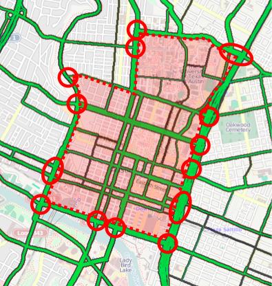
- Reduced city-wide motor vehicle trips. Citywide, a reduction of 170,000 daily driving trips, equating to 460,000 daily miles traveled.
- Regional mobility and congestion management. The 20,000 additional bicycle trips to central Austin because of the 2014 Plan’s $151 million all ages and abilities bicycle network would results in the same increased motor vehicle capacity as the MoPac Improvement Project, a $190 million 11-mile urban freeway project adding a single managed lane in each direction. This demonstrated that the investment in the All Ages and Abilities Bicycle Network is on par with other large mobility projects in managing regional congestion.
- Boost Affordability - By offering people a viable low-cost transportation option, the bicycle network can help families significantly cut the household expense of owning and operating a vehicle. Due to decreased vehicle miles traveled, individuals would save $170 million in direct driving costs annually.
- Public Health Benefits - Increasing the percentage of travelers who regularly bicycle for transportation directly correlates to improved public health. The increased physical activity associated with shifting short trips to bicycle trips would equate to 130,000 people, or at the time, 15% of Austinites meeting their daily minimum physical activity. Savings from avoidance of disease associated with sedentary lifestyle per person is estimated at $128 per person, for a total benefit of $16.6 million per year.
- Environmental Benefits - By reducing vehicle trips, riding bikes and scooters reduces the pollution from motor vehicles. This, in turn, reduces the costs to mitigate environmental damage and public health impacts from air pollution that vehicles create. For example, the estimated reduction in miles traveled would result in a reduction of 84,000 metric tons of carbon per year, the equivalent of the carbon generated by the driving habits of Austinites over 11 days.
Note that while this analysis was conducted in 2014 and was not updated for this plan the findings are still relevant today. The analysis was conducted for a much smaller All Ages and Abilities Bicycle Network (~400 miles vs. the current 1,600 miles). While the cost of investment has increased due to network expansion and increased quality, the benefits are also anticipated to increase, and this plan continues to recommend that investment in the network should be considered of a regional scale and importance.
CITY OF AUSTIN RECOMMENDATIONS FOR TXDOT ROADWAYS
Texas Department of Transportation (TxDOT) roadways play a critical role in the bicycle network as they are often high speed and volume roadways, that are barriers to people on bikes. TxDOT roadways include highways, urban arterials within the city limits, and controlled access freeways with limited crossings. For the purposes of this document, they will all be referred to as TxDOT roadways whether they are operated by TxDOT or by others, such as the Central Texas Regional Mobility Authority (CTRMA). One of the fundamental goals of this Plan is to implement bicycle and pedestrian facilities that are accessible to people on bicycles and walking of all ages and abilities. For Austin’s bicycle network to be whole this approach will have to be extended to TxDOT roadways and crossings as there are many destinations and mobility demands both along and across the TxDOT corridors. Many TxDOT owned and operated roadways within this plan are within the City of Austin extraterritorial jurisdiction. The character of TxDOT roadways is often different from City streets and require special consideration:
- Need for Physical Protection - TxDOT roadways are nearly exclusively highspeed and high-volume motor vehicle environments and necessitate high quality physical separation from motor vehicle traffic. Travel speeds on frontage roads, highways, and suburban arterials are often in the 45-60 mph range where any collision between a person walking and bicycling and a motor vehicle will be fatal.
- Need for Safe Crossings and Two-way Access - Controlled access highways allow only limited crossings. Existing crossings, often spaced between ½ to 2 miles apart are critical to be able to cross by bicycle or walking for people of all ages and abilities. The other effect of limited access combined with one-way frontage roads is the potential to generate significant route delay if two way facilities are not provided on each side of the street. To reduce route delay, it is also critical to reduce the maximum distance of safe crossing locations to ½ mile spacing, providing non-vehicle crossings if motor vehicle crossings are not necessary, as well as ensuring that all bicycle, pedestrian, and trail pathways (e.g., trails along creek corridors) are safety connected across the corridor.
- Need for Shade - Generally the limited crossings, low density land uses, and heat island effect of these corridors make for longer trips and need for shade. The City should continue to work with TxDOT to find ways to plan trees that provide shade while still meeting TxDOT’s road safety criteria.
- Need for Lighting – The high motor vehicle speed and volumes along TxDOT corridors exacerbate known trends of reduced safety for people walking and bicycling along streets at night. While people on bicycles are required to have a front light (can be dim) and a rear reflector it is important to acknowledge that people walking and bicycling with little or no lighting can be nearly invisible compared to motor vehicles with headlights and running lights. The high speeds of these corridors result in less reaction times to avoid collisions. Furthermore, headlights from motor vehicles affect the night vision of people walking or bicycling which makes it more difficult and dangerous to navigate pathways. This plan recommends working with TxDOT to provide shared use path illumination along all corridors.
SPECIAL CONSIDERATIONS FOR TXDOT ROADWAYS
Recommendations in this plan on TxDOT roadways warrant special consideration. While many of these roadways are within the City of Austin or the extraterritorial jurisdiction and in the jurisdiction of this plan, the roadways are owned and operated by TxDOT or partner agencies. It is important to clearly state how this plan affects the planning, scoping, and delivery of TxDOT projects.
The intentions of the recommendations in this plan are as follows:
- To document best practice and local approach in accommodating people on bicycles of all ages and abilities on Austin’s roadway network, including TxDOT roadways.
- The Plan acknowledges that TxDOT and City of Austin have different design standards, internal processes, and public processes. This plan recommends working together to achieve the highest quality bicycle and pedestrian network that meets the goals of this plan.
- The Plan acknowledges that each project on a TxDOT roadway will have different context, constraints, scopes, available funding, timeline, and public process and recommends the City of Austin and TxDOT work together to achieve the highest quality bicycle facility on each project to the extent possible.
RECOMMENDED APPROACH FOR TXDOT ROADWAY TYPES
At the time of the 2014 Bicycle Plan, there was a significant evolution in thought related to providing bicycle accommodations among TxDOT staff, bicycle program staff and bicycle stakeholders groups. The most significant change was an awareness that we have a responsibility to make our roadways accessible for all modes and people of all ages and abilities. This includes travel along, across, and to and from destinations along the corridor. The subsequent question becomes what types of facilities can meet this goal on TxDOT roadways. The 2014 Plan established that wide curb lanes are not a safe or appropriate accommodation on TxDOT’s high-speed roadways.
Over the last 10 years a much stronger collaborative relationship and strategic partnership between TxDOT and the City of Austin on a range of issues including improved pedestrian and bicycle accommodations and transit needs now exists. This Plan represents a significant opportunity to continue to find common ground with TxDOT as an agency partner to better align our approach to bicycle facilities, conforming to national best practice.
This Plan recommends four different approaches for bicycle facility types on TxDOT roadways, dependent on the context of the roadway. This Plan recommends the following bicycle facilities along each TxDOT roadway type:
CONTROLLED ACCESS FREEWAYS AND FRONTAGE ROADS WITH LIMITED ACCESS
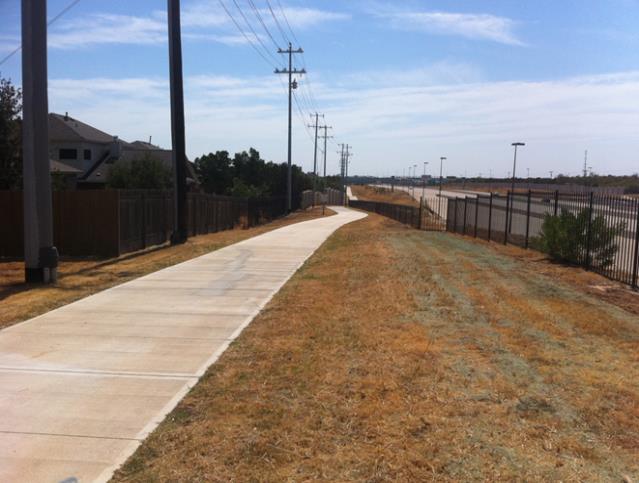
As noted, because of the limited crossing opportunities, the one-way nature of frontage roads and main lanes, and the presence of destinations on both sides of the facility, it is important to provide twoway access to pedestrians and cyclists on both sides of the corridor due to their high sensitivity to longer trip distances. Due to the high speeds and volumes of these roadways it is necessary for pedestrian and bicycle facilities to be physically protected. These roadways often have a low to medium density of driveways and intersections that reduce conflict points and improve the safety and operations of bidirectional off-street bicycle facilities. Pedestrian densities along these corridors are typically low to medium, except for roadways in the central city and where other high demand drivers exist (e.g., schools or large apartments), which result in acceptable operations along shared use paths where people walking and bicycling share the space.
Along controlled access freeways with limited access this plan recommends two way shared use paths along both sides of the roadway since there are destinations on both sides of the roadway. This plan also recommends trail scale lighting, safe crossings every ½ mile, and trees for shade.
Shared use paths and safe crossings have been included on many highway projects including: IH35, Oak Hill Parkway, 183 South, and 71 Expressway. Unfortunately, only portions of the older US 183 North, and Mopac Expressway project included safe all ages and abilities bicycling facilities.
MAJOR HIGHWAYS
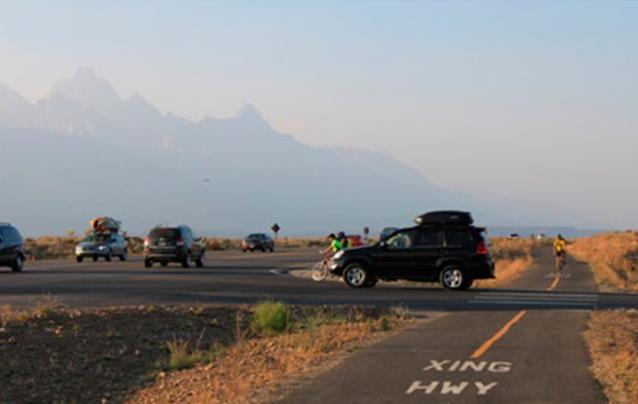
Major highways are also high speed and high-volume roadways that should have physical protection for people walking and bicycling. Intersections are often limited but often closer spaced than along controlled access highways. These roadways often have moderate number of driveway, intersection, and pedestrian densities making protected off-street bicycle facilities preferable to on-street protected facilities.
Since these roadways offer more frequent crossing opportunities this plan recommends two-way shared use path along one side of the roadway and either a sidewalk or shared use path on the other side of the roadway to provide local access to destinations. This plan also recommends trail scale lighting, safe crossings every ½ mile, and trees for shade.
This strategy has been implemented along FM 969 and Parmer Lane.
URBAN ARTERIALS AND FRONTAGE ROADS WITHOUT LIMITED ACCESS
The Plan recommends almost all city arterials have protected bicycle lanes in urban areas. These high speed and volume roadways warrant physical protection but have moderate to high numbers of driveways, intersections, and pedestrian levels that increase complexity and risk of an off-street bidirectional shared use path.
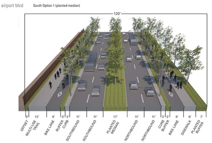
The Plan recommends providing one-way protected bicycle lanes on each side of the street, in addition to adjacent sidewalks. This plan also recommends street lighting, safe crossings spacing per the Transportation Criteria Manual, and trees for shade.
This strategy is being implemented along TxDOT’s portion of the Airport Boulevard Corridor Project.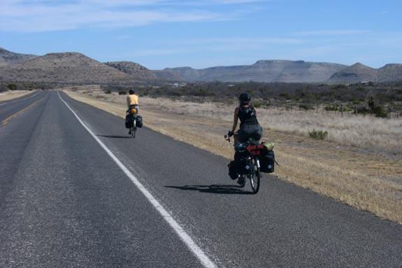
MINOR / RURAL HIGHWAYS
In outlying areas, there are TxDOT roadways that have high speeds and low to moderate volumes or have limited short trip travel demand. While it is important to provide all ages and abilities bicycle accessibility on all roadways, in some cases a wide shoulder could be acceptable at low motor vehicle volumes.
At low volumes (including forecasted volumes) where it is not possible to provide a shared use path this plan recommends wide shoulders.
RECOMMENDED FACILITIES ON TXDOT ROADWAYS
The following map shows the roadways where shared use paths (urban trails), protected bicycle lanes (protected), and bicycle lanes/shoulders are recommended.
CITY OF AUSTIN BICYCLE FACILITYRECOMMENDATIONS FOR TxDOT ROADWAYS
Design Flexibility
In August 2013, the Federal Highway Administration issued a memo in support of design flexibility for bicycle and pedestrian facilities. This memo offers the use of the NACTO Urban Bikeway Design Guide and the ITE Designing Walkable Urban Thoroughfares: A Context Sensitive Approach. This document provides options to further develop non-motorized transportation networks, particularly in urban areas. It also lays the groundwork for Austin to create tailored recommendations on how to best provide bicycle facilities on these types of roadways in a way that could be supported by City staff, TxDOT, project consulting teams, bicycle community stakeholders and the Federal Highway Administration.
Stakeholders worked to develop recommendations for bicycle facilities along high-speed roadways with limited access (excerpt shown to right). The recommendations offer proposed shared use path configurations at various widths representing varying rights of way constraints. It includes recommendations for two-way paths that are as narrow as 8 feet wide with a 2 foot colored and textured hardscaped buffer to the roadway edge. The proposed buffer offers a compact means of providing separation from traffic, addressing maintenance concerns of narrow planted areas, and allowing a rideable and walkable surface in the event of passing movements. Narrower options are offered in less than 8 feet shared use
path widths for the most constrained conditions that can certainly be defended as one way facilities. The intent of using design flexibility in developing these recommendations is to expand the toolbox for providing quality bicycle facilities in constrained conditions. Austin’s Bicycle Advisory Council reviewed the attached guidance in their February 18, 2014 meeting and passed the following resolution:
“THE BICYCLE ADVISORY COUNCIL ENDORSES THE PRESENTED ‘GUIDANCE FOR BICYCLE FACILITY RECOMMENDATIONS ALONG HIGH-SPEED ROADWAYS WITH LIMITED ACCESS’ AS VASTLY SUPERIOR TO A WIDE CURB LANES WITH THE FOLLOWING DISCUSSION POINTS INCORPORATED: INCLUDING TEXT FOR HIGH PEDESTRIAN DENSITIES AND WHEN THE PATH IS BELOW 8 FEET CONSIDER THE OPTION OF A BICYCLE LANE.”
This Plan recommends City staff, TxDOT, project consulting teams, bicycle
community stakeholders, and the Federal Highway Administration continue developing flexible design approaches and a toolbox to better accommodate people on bicycles of all ages and abilities in constrained conditions.
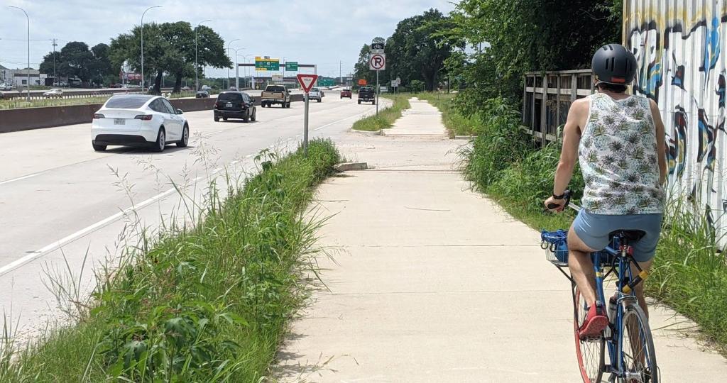
BICYCLE NETWORK STRATEGIES AND ACTIONS IN REVIEW
The following section reviews the highest priorities for the development of the bicycle network.
Bicycle Network Strategy 2.1) Create an All Ages and Abilities Bicycle Network
The first infrastructure recommendation will be the build-out of the All Ages and Abilities Bicycle Priority Network. The network includes facility recommendations that would serve much of the population including those who are interested in riding a bicycle but concerned about safety due to motor vehicle traffic. Investment in these facilities would be targeted towards capturing short trips on the travel network to maximize return on investment. As funding for portions of the network becomes available, an implementation plan would be developed, detailing the most strategic facility investments that would be pursued at that time.
Total Estimated Cost: $1 billion (included estimated funding from multiple agencies)
Strategy 2.1 Indicators and Targets
- Complete 380 miles of the All Ages and Abilities Bicycle Priority Network by the end of 2026; 480 miles by the end of 2029; and 660 miles by the end of 2033. This translates to 35 miles of AAA Network buildout per year between 2023 and 2026 and 40 miles per year between 2027 and 2033. These goals are for the full AAA Network including quick, medium, and full build quality.
- Track the percent of the completed AAA Bicycle Priority Network that is at full (permanent bikeway physical protections, protected intersections, and quality bus stops integrated with protected bicycle lanes) and medium build quality.
- Complete the following bicycle infrastructure at full build quality annually (new or upgrade): 5 miles protected bicycle lanes, 5 protected intersections, 10 bus stops. Track cumulatively over time over time meeting the following targets by 2033: 62 miles of protected bicycle lanes (12 existing miles), 66 protected intersections (12 existing), 125 bus stops (25 existing).
- Complete an additional 5 miles of protected bicycle lanes at medium build quality. Track cumulatively over time over time meeting the following targets by 2033: 52 miles of protected bicycle lanes (2 existing miles).
- Annually contact adjacent and regional jurisdictions to discuss bicycle system and connectivity improvements needed to realize our proposed system.
- Address issues of parking in all bicycle lanes by 2024.
- Establish a citywide ordinance prohibiting parking in bicycle lanes by 2024.
Strategy 2.1 Action Items
2.1.4 - Fund and implement the all-ages and abilities bicycle network as a top priority including both on-street bike ways and off street urban trails.
2.1.4a - Utilize quickly build techniques (paint and flex posts) to rapidly implement the AAA Bicycle Priority Network but achieve full build quality (concrete and landscaped bicycle
barriers, protected intersections, and green street elements) in a phased approach over time.
2.1.4b - Use protected intersection approaches as the standard intersection design.
2.1.4c – Strategically invest in the AAA Bicycle Priority Network using the project prioritization model and programmatic project selection.
2.1.4d – Evaluate bicycle infrastructure use, safety, and needs to inform prioritization for improvements and full build quality upgrades. Prioritize streets where people routinely drive over 30MPH for full build quality.
2.1.4e – Provide at minimum annual updates on prioritization, upcoming projects, and overall timelines for a full build-out of the system.
2.1.4.f – To support implementation of full build approaches (e.g., concrete bicycle lane barriers, protected intersections, and crossing islands) at scale revise the Drainage Criteria Manual (DCM) to allow flexibility in DCM requirements to support cost effective and high-quality multimodal safety improvements to existing streets.
2.1.4g - Use the latest available versions of leading national and international design guidance to inform bicycle infrastructure planning, design, and best practice resources including but not limited to NACTO, CROW and AASHTO guidance.
2.1.4h - Ensure that all neighborhood bikeways meet stringent national best practice performance requirements. Assess existing Neighborhood Bikeways; if performance requirements are not met, make necessary changes.
2.1.5 - Eliminate gaps in the existing bicycle network to allow continuous bicycle travel in the Austin area.
2.1.5a - Coordinate bicycle transportation into all roadway and park land design, planning, and construction manuals, standards documents, and projects.
2.1.5b - Require interim, first phase of roadway construction to provide bicycle facilities.
2.1.5c - New development that abuts or includes existing or planned AAA Bicycle Network shall provide continuity of that route (and existing or planned bicycle facility) through or along the property serving travel demand for that development or surrounding land patterns.
2.1.5d - Annually contact adjacent jurisdictions to discuss bicycle system and connectivity improvements needed to realize our proposed system.
2.1.5e - Evaluate opportunities to allow bicycle access where currently prohibited including right turn only lanes, dead ends, and one way streets to ensure that bicycle travel is as convenient and direct as possible.
2.1.6 – For projects that require choices to determine the best balance of potential changes within the right-of-way given competing interests, conduct robust equity centered public engagement.
2.1.6a – Conduct public engagement in a trust building way with public stakeholders about the choices at hand and what the effect and outcome of these choices are to determine the best use and configuration of the public right of-way and alignment with City policy
goals.
2.1.6b – Ensure that public engagement is centered in equity understanding the needs of local communities. This can include providing translated project materials, interpretation at public
meetings, conducting additional meetings to move at the speed of trust, having community ambassador support for project-based engagement and other best practice approaches.
2.1.7 - Make key operational improvements to the existing and recommended bicycle network.
2.1.7a - Make sure that all bicycle detection works at all traffic signals and hybrid beacons. Provide detection indication where appropriate.
2.1.7b – Utilize smart signals that can detect all users and adaptive timing to avoid unnecessary delay.
2.1.7c - Improve bicycle accommodations on bridges.
2.1.7d - Improve intersections to facilitate bicycle safety and comfort.
2.1.7e - Utilize best practice tools to implement this plan, such as protected intersections, bicycle signals, leading bicycle and pedestrian signal phasing, colored bicycle lanes, advanced stop lines/bike boxes, lane diets, road diets, etc.
2.1.8 - Amend Land Development Code (LCD), Subdivision Regulations, and Austin Strategic Mobility Plan to support implementation of the physical bike network, transit integration, and end of trip facilities recommended by this Plan. For additional LCD recommendations for the physical bicycle network see Chapter 4 Implementation, section Regulations.
2.1.8a - Establish more detailed criteria for providing bicycling facilities on new streets, including internal circulation, driveways, and trail alignments where the driveway serves as a continuation of an existing or planned bicycle route.
2.1.8b - Continue development of code changes with a diverse group of stakeholders including community members, interdisciplinary affordability anti-displacement, employment, market and affordable housing developers, site engineers, business owners, and advocacy organizations that support the goals of this plan.
2.1.8c - Ensure that implementation of protected bicycle lanes on key corridors by private developments are met through the development process.
2.1.8d - Establish and provide incentives and / or requirements for bicycle network facilities and end-use facilities in private developments.
2.1.9 - Use consistent standards to identify and design bicycle facilities.
2.1.9a - Regularly update the Transportation Criteria Manual, associated standard details, and Land Development Code as necessary as it pertains to street design, connectivity to ensure that new projects and developments meet the physical recommendations of this plan and make bicycling safe, comfortable, and convenient.
2.1.9b - Use national, international, and local best practices for bicycle facility planning and design guidance.
2.1.10 - Coordinate with other city departments and public agencies to implement the recommended bicycle network.
2.1.10a - Coordinate with the Urban Trails Program, Parks and Recreation Department, and other relevant departments / programs, public agencies, and non-profits to integrate on and off-street networks and prioritize connections that meet the goals of this plan.
2.1.10b - Work with all departments and partners agencies to support the implementation of the 2014 Complete Streets Policy.
2.1.10c - Authorize City Bicycle Program Manager to review all City and applicable private development plans (zoning, subdivisions, site plan, etc.) that add to or affect the operation of the bicycle network. Include Bicycle Program Manager in the review process for applications to vacate rights-of-way and exceptions or variances to these.
2.1.10d - Coordinate with Texas Department of Transportation, Capital Area Metropolitan Planning Organization, Travis, Williamson, and Hays Counties and other jurisdictions and agencies to ensure appropriate bicycle connections are planned, constructed, and maintained, where feasible, to promote a regional on-and off-street bicycle network.
2.1.10e - Coordinate with Austin Energy to incorporate bicycle facilities in utility rights-of-way and in conjunction with the installation of utilities, where feasible.
2.1.10f - Coordinate with higher education institutions on improving bicycle access to, from, and within campuses and other major properties owned by those institutions.
2.1.11 - Establish standards for bicycle detours in the event of construction, street closures, or special events that impact bicycle facilities, particularly to maintain all ages and abilities facility quality.
2.1.12 – Provide timely updates of infrastructure changes to popular navigation apps and services so people can reliably find the safest and best route.
2.1.13 – Anticipate and proactively plan for the coming proliferation of autonomous vehicles.
2.1.13a – Establish policies and practices related to autonomous vehicles that support established mobility, safety, and city-wide goals to prevent these goals from being undermined.
2.1.13b – Follow the best practice design guidance available that addresses safety related to automated vehicles and recommended design measures to protect vulnerable users (e.g., people who travel by foot, bicycle, scooter) in the design of bikeways and streets.
BICYCLE FACILITY MAINTENANCE
Strategy 2.5: Provide Excellent Bicycle Facility Maintenance
Maintenance of bicycle facilities is critical to keeping them safe and usable through their life cycle. Designing bikeways to reduce maintenance needs, giving attention to sweeping the sides of streets where bicyclists ride, and ensuring that riding surfaces are relatively smooth are all requisites in attracting more of the public to bicycling.
Maintenance of the bicycle network is typically done through regular roadway and park maintenance, depending on the facility. The primary on-street roadway maintenance activities include road resurfacing, street sweeping, maintenance of barriers on protected bicycle lanes, the treatment of bicycles through temporary road conditions and the operations of the signal system are elements. Urban Trails are maintained either by the Transportation and Public Works or Parks and Recreation Departments.
“IS THERE ACTUALLY MAINTENANCE? WHERE AND WHEN ARE THE NARROW STREETSWEEPERS BEING USED? I HAVE NEVER SEEN ONE AND AM ON A BIKE ALMOST EVERY DAY EXPLORING OUR CITY. I OCCASIONALLY TAKE THE TIME TO DRAG A ROLLER MAGNET ON OUR BIKE LANES AND ON THE AVERAGE PICK UP 20# OF METAL IN A 10 MILE STRETCH. THIS IS NOT GOOD FOR BIKES OR CARS. TIRES ARE EXPENSIVE AND I WOULD GUESS THAT OVER HALF OF THE RIDERS IN TOWN DO NOT KNOW HOW TO FIX A FLAT.”
MAINTAINING PROTECTED BICYCLE FACILITIES
Protected bicycle lanes introduce several maintenance and operational needs and challenges. New bike lane barriers in the rights of ways must be maintained and should not obstruct City services such as street sweeping and recycling and waste collection services. New approaches to operations and design criteria will ensure that protected bicycle lanes are properly maintained.
The physical barriers used to protect bicycle lanes will also need maintenance. Some barrier solutions will last longer than others, but all will have a life cycle and need repair or replacement. Coordination between Transportation and Public Works Department and other relevant departments is necessary to budget for ongoing maintenance that provides high quality facilities throughout their lifespan.
VEGETATION
Vegetation maintenance is important for the quality of bicycle facilities. Like sidewalks and Urban Trails unmaintained vegetation can block and obstruct bicycle
lanes and make using them less safe. Also, with the opportunity to incorporate green street infrastructure with bicycle infrastructure including approaches to provide shade trees and rain gardens it will be important to ensure that the trees and vegetation have adequate levels of maintenance. With any plantings the goal will be to implement low maintenance techniques using native and adapted plant species and plan for no-mow or low-mow maintenance.
Maintenance of vegetated areas are also a great opportunity to build community partnerships that can build pride in projects. Community groups can have a large degree of control of the nature of plantings and maintenance. Maintenance is also discussed in the prior section on Shade and Green Infrastructure above.
PROTECTED BICYCLE LANE BARRIERS
For the comfort and safety of protected bicycle lanes to be maintained it is necessary to maintain the condition of the barrier. Depending on the speed and volume of motor vehicle traffic, the lane widths, and quality of the barrier used, barriers will need varying levels of maintenance. Design of projects works achieve projects that have the lowest possible maintenance costs and resource burdens while maintaining high quality physical protection. Maintenance of bicycle lane barriers is paid for by the City’s operating budget.
PAVEMENT SURFACE
Bicycles are more sensitive to irregularities and road debris than cars due to their smaller and lighter weight tires and lack of suspension. Roadway features that cause minor discomfort to motorists, such as potholes, improper drain grates, and loose rocks from seal coat treatments, can cause serious problems for cyclists. Even some “normal” features of road design can cause an inconvenience or danger for cyclists. “Safety features” like large, closely spaced rumble strips designed to alert motorists leaving the roadway create barriers and hazards for cyclists. All operational applications to roadways which serve as bicycle routes should be reviewed for the best application assuming bicyclists will be on the roadway.
Bicyclists and other road users can file maintenance requests and complaints through the City’s 3-1-1 system. Calls into the 3-1-1 system typically regard debris in
bicycle lanes and parking in bicycle lanes. Depending on the issue, typically either the Transportation and Public Works, Austin Resource Recovery, Watershed Protection, or the Parks and Recreation will work to resolve the issue.
Another routine street maintenance activity that can be bothersome to bicyclists is preventive maintenance surface treatments. Preventive maintenance is the most cost-effective way for the City to assure long lasting streets. There are several pavement surface techniques used by the City: Hot mix paving, microsurfacing or slurry seal, and sealcoat (chip seal).
Streets that are sealcoated often generate complaints from people riding bikes and scooters due to loose aggregate that can last a month or two after application. Sealcoat is applied in two stages, first an asphalt emulsion is applied, and then loose rocks are distributed on top. Over time the aggregates settle into the asphalt emulsion which cures, and the street hardens. Until the emulsion hardens, rocks can come loose and will accumulate on street corners and near gutters requiring sweeping until all loose rocks are removed. The pavement surface is initially rough until the aggregate has time to sink in. While the other street maintenance treatments preferred by cyclists initially since they don’t have a curing period, sealcoat is a very cost effective method, approximately 1/5th the cost of hot mix overlay and gives the City the opportunity to reconfigure streets to achieve higher quality bicycle infrastructure. City staff annually review of the sealcoat street maintenance program for the upcoming year and determine which streets can have new or improved bicycle and pedestrian facilities. Transportation and Public Works Department should use finer sealcoat rock and ensure adequate curing and sweeping along bicycle routes to provide a safe and comfortable roadway surface.
Slurry seal is textured, skid resistant, flexible, waterproof, and has good cohesion, which allows it to be an economic and hard wearing surface. The process adds no structural strength to the pavement but does result in an extended service life – about seven years - depending on the volume of traffic. Slurry seal is a great preventive maintenance treatment for streets that are still in good condition with very little cracking. Microsurfacing has the same texture and finish as slurry, but is a little stronger, creates a more level surface, and is consequently more expensive. Microsurfacing is more stable and longer lasting under heavier traffic and is most
often used on arterial and collector streets.
Thin surface treatments are planned for summer and early fall. Warm, dry weather is required for this type of work to be successful. Fortunately, this work is relatively quick, and the roadway is returned to normal traffic use within hours. Transportation and Public Works Department prioritizes asphalt overlays or reconstruction for the rehabilitation of streets in the poorest condition; however, there are hundreds of neighborhood streets in this category. A sealcoat is often used in this case to “buy time” by preserving whatever value is left in these old pavements. This means that some bicycle routes will still receive a sealcoat. There are still quite a few older streets that we cannot afford to overlay or reconstruct within current budgets.
Innovative pavement for streets or trail connections should be explored such as asphalt and sealcoat that matches the standard terracotta bike lane color, equipment that can maintain narrow protected bicycle lanes (standard sized equipment currently cannot), and other innovative pavement systems that use recycled materials.
STREET SWEEPING
Street sweeping and bicycle lane sweeping is another routine maintenance that is important for safe and reliable use ability of bicycle facilities keeping them free of debris such as gravel and glass. With painted bicycle lane, bicycle lane sweeping happened as part of regular street sweeping.
Sweeping of protected bicycle lanes often requires narrower equipment. As street and ROW space is limited it is often not feasible to provide the 8.5 feet clear width required to operate typical larger street sweepers. To provide protected bicycle lanes in most cases it will be necessary to have the capability to sweep spaces as narrow is 6-7 feet wide. The plan recommends that narrow sweeping equipment or services continue to be proactively acquired to support the rapid expansion of the protected bicycle network.
Because bicycle tires are more susceptible to flats and debris is a bigger issue due to the need to balance compared to motor vehicle sweeping needs it is important to monitor and adjust bike lane and protected bicycle lane sweeping frequency as necessary. As a result, it is expected that bicycle lane sweeping needs are as or more frequent than the traditional thoroughfare and residential street schedules. Sweeping needs may vary depending on the street and careful and tailored management of sweeping schedules can help best allocate resources while keeping a high standard of care.
SIGNAL DETECTION
One maintenance issue with the bicycle network is traffic signals that detect automobiles fail to respond to cyclists. As a result, people on bicycles choose to disregard red lights and even worse the behavior may transfer over to a disregard for all traffic controls. The Plan recommends that the bicycle system, including traffic signals, shall accommodate cyclists like all other road users.
TEMPORARY TRAFFIC CONTROLS AND CONSTRUCTION ACTIVITIES
Temporary construction along bikeways can create a big obstacle to bicyclists when an excess of debris is in the roadway and bikeway. When streets are completely closed off, bicyclists are forced to find an alternative route. Barricades for construction often obstruct bicycle travel. Steel plates over excavations are very hazardous to cyclists. Roadway construction often reduces roadway space, increasing the difficulty for motorists and bicyclists to share the road. Roadway construction should include steps to prevent added risk to cyclists from debris and reduced roadway space. It is often assumed that any barrier or alternative route provided for motor vehicles is also adequate for bicyclists. This is not always the case. Simple improvements to temporary construction closures can ensure continued and safe bicycle use in the area. Additionally, the Texas Manual on Traffic Control Devices (TMUTCD) requires that bicycles be safely accommodated during temporary traffic control on bicycle routes.
BICYCLE FACILITY MAINTENANCE STRATEGIES AND ACTIONS IN REVIEW
Strategy 2.5 Indicators and Targets
- Include maintenance of all aspects of the All Ages and Abilities Bicycle Network within the operating budget of Transportation and Public Works Department and any other Departments necessary to achieve a high standard of care on an ongoing basis.
Strategy 2.5 Actions
2.5.1 - Provide ongoing and regular maintenance for all bicycle facilities.
2.5.1a - Proactively budget and plan for the maintenance needs of all aspects of the All Ages and Abilities Bicycle Network within the operating budget of Transportation and Public Works Department and any other Departments necessary to achieve a high standard of care on an ongoing basis.
2.5.1b - Maintain the hardscape (and other aspects in their purview) of the All Ages and Abilities Bicycle Network infrastructure including protected bicycle lane barriers and pavement at good or acceptable condition.
2.5.1c – Develop standards to ensure that pavement maintenance types and processes are safe and comfortable for people on bikes and scooters including using finer seal coat rock for bicycle facilities and ensuring that any loose rock during the cure period is promptly removed.
2.5.1d – Maintain all bicycle markings, flex posts, concrete buttons, and signs.
2.5.1e - Sweep all bicycle lanes, protected bicycle lanes, shared use paths, and sidewalks regularly to remove glass and debris that endanger or inconvenience people bicycling and walking.
2.5.1f - Develop and conduct proactive strategies for bicycle network maintenance including regular audits of infrastructure condition and maintenance of any issues.
2.5.2 – Ensure that departments obtain and operate necessary specialized equipment for the construction, maintenance, and operation of bicycle infrastructure.
2.5.2a – Work with Transportation and Public Works Department to proactively acquire staff and budget for narrow street paving equipment or services to address sweeping of protected bicycle lanes.
2.5.2b – Work with Austin Resource Recovery to proactively acquire staff and budget for narrow street sweeping equipment or services to address sweeping of protected bicycle lanes.
2.5.3 - Train 311 call takers regarding bicycle related calls and ensure proper routing of calls.
2.5.4 - Develop maintenance capacity, data tracking, and training for tree and vegetation maintenance in partnership with internal and external entities and the public at large. Consider partnership with entities such as Austin Civilian Conservation Core, American Youth Works, or similar programs to leverage placemaking and community capacity building opportunity.
TRANSIT & MOBILITY SERVICES
This section covers seamlessly integrating transit and bicycle systems as well as other mobility services such as public bike share, scooters and other micromobility, and rideshare and car share services.
Integrating bicycle and transit systems combines the strengths of each mode of travel and is a primary goal of this plan. Feeding transit with bicycle trips in addition to walking trips significantly increases the number of people who can reach transit.
Bike share is a great tool to flexibly make the “last mile” connection and is discussed more in the Bike Share System section below.
Scooters and micromobility services use bicycle infrastructure and ride and car share services support shifts to bicycling by providing flexibility for people to make unexpected trips.
TRANSIT + BICYCLE SYSTEM INTEGRATION
Integrating transit and bicycle systems combine their strengths which helps overcome their individual weaknesses. This section covers these concepts and strategies to integrate the two systems. It is important to provide all ages and abilities bicycle routes to feed major transit stations. High capacity and secure bicycle parking should be provided at transit stops so bicycles can be parked and not take up valuable space on transit vehicles during peak periods. Strategies to get more bikes on transit vehicles such as racks on buses that hold three bikes should be pursued to enable more flexible trips.
FEEDING TRANSIT
Feeding transit with bicycle trips in addition to walking trips significantly increases the number of people who can access and make time competitive trips with transit. Public transit services are highly sensitive to the distance between user’s residences and the nearest transit stop. Lower density developments have traditionally been considered poor candidates for transit services because of the increased distance to transit stops (this is commonly referred to as the “first and last mile problem”). Bicycles and scooters can effectively
increase the service area for either end of a transit trip and or reduce the time for these connections. Another benefit is that people using bicycles to access transit can often increase the number of transit lines available to them which could result in a more direct transit trip that reduces the overall trip time. All these strategies expand
the trips that users can make by combining bikes and transit giving people more access to services and opportunity.
There are additional benefits to be gained from joining bicycles with transit which each mode alone cannot provide: transit enables the bicyclist to take longer trips; transit enables the bicyclist to pass over or through topographical barriers (Doolittle, 1994, p. 1). Combining transit and bicycle trips makes it possible for those who have even relatively long trips or commutes to benefit from an active bicycle commute linked with a high quality transit experience free from the stresses of driving in traffic.
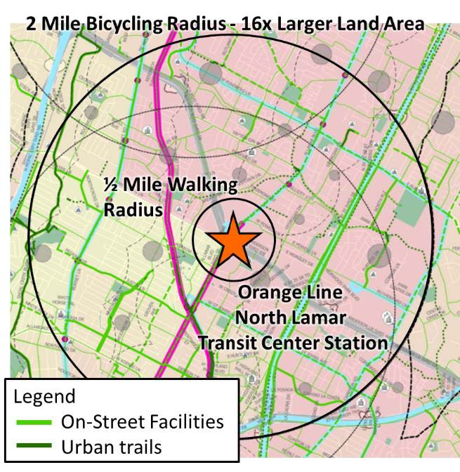
Following international best practice this plan assumes that users would reasonably take bicycles or scooters 2 miles to rail stations, 1.5 miles to express bus stations and 1 mile to other bus services (rapid, frequent, and local). For rail stations this results a 16x increase in land area feeding transit compared to a typical ½ mile walking radius.
Transit System
- Strengths
- High people carrying capacity
- Better for longer trips
- Space efficient
- Weaknesses
- Inflexible
- Limited reach to individual destinations
- Requires feeder systems
Bicycle System
- Strengths
- Flexible
- High reach to individual addresses
- Fast on short distances
- Uses little space for parking
- Weaknesses
- Limited trip distance
How the Dutch Access Transit 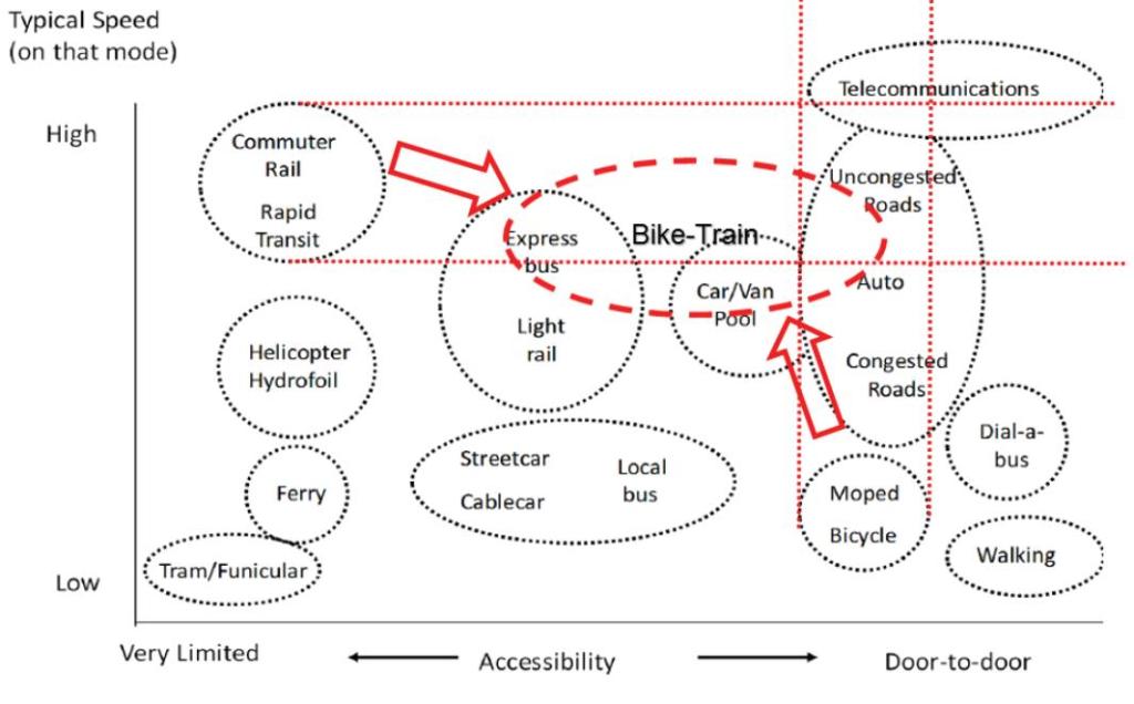
The following data from the Netherlands where all mobility systems are safe and integrated. The data shows differences in travel patterns based on lower density home stations (closer to home) and egress station (near destination):
- Home Station Access: 40-50% of transit users arrive by bicycle compared to 20-30% by walking.
- Egress Station Access: 10-15% of people finish their trip by bicycle compared to 40-50% by walking.
Bicycle and scooter feeder for each of these service levels is commensurate with the speed, reliability, and capacity of each of these transit services since it is the whole trip (accessing transit, the transit trip, and accessing the destination) that comprise the time budget for the trip.
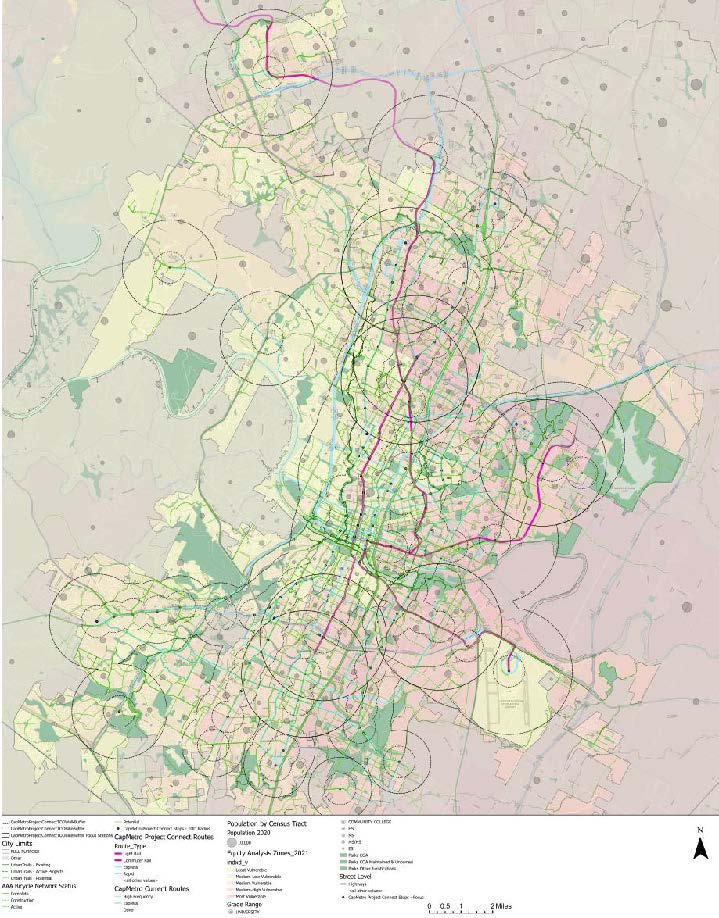
The City of Austin, Capital Metro and other regional partners have developed a regional high-capacity transit framework called Project Connect. With the first phase of
Project Connect funded by voters in 2020 there is significant opportunity to feed stations with all ages and abilities bicycle networks along the new two light rail lines, two commuter rail lines, express bus stations, and rapid bus lines in addition to existing service. The map to the right shows the walking and bicycling radius for each of these stations.
“SINCE EQUITY IS A PRIMARY FOCUS OF THIS PLANNING EFFORT AND IN THE SPIRIT OF INTEGRATED PLANNING, IT IS ALSO IMPORTANT TO COLLABORATE WITH CAPMETRO AND ADVOCATE FOR FILLING GAPS IN TRANSIT SERVICE. FEEDBACK DURING ATX WALK BIKE ROLL IDENTIFIED EQUITY RELATED GAPS IN EAST/WEST SERVICE, OVERNIGHT SERVICE GAPS NEEDED BY LOW-INCOME SERVICE WORKERS.”
EVOLVING TRADITIONAL TRANSIT ORIENTED DEVELOPMENT TO EQUITABLE HYBRID (WALK+BIKE) TRANSIT ORIENTED DEVELOPMENT
Transit Oriented Development (TOD) planning in Austin and many other places have traditionally focused on walkable transit supportive urbanism and redevelopment for station areas without attention to equitable outcomes, protecting against displacement and integrating bicycle mobility into station area planning. The following italicized text is from CapMetro’s Equitable Transit-Oriented Development Website.
THE TRADITIONAL TOD APPROACH
As cities like Austin grow, it becomes increasingly important to develop policy, programs, and networks that support affordable density, and allow people to get to the places they need to go. Traditional approaches to build a city responsive to these needs are bundled under the umbrella term, transit-oriented development, or TOD. TOD is a way to build cities that prioritize tightly connected neighborhoods with a mix of residential and commercial uses. It is not a building or a project; it's a pattern of development that is:
- Compact and relatively dense.
- Within walking or biking distance of
transit. - Mixed-use, including housing, jobs,
services, shopping and fun. - Safe, walkable, interconnected, and
lively.
These vibrant and walkable neighborhoods offer residents more choices regarding how to get around, whether walking, biking, or riding transit, and more destinations for retail, dining, and entertainment. In this way, TOD supports CapMetro’s goals for environmental sustainability and economic development.
SPOTLIGHT: Integrated Land, affordability, and multimodal planning
M STATION - M Station is a project by Foundation Communities, a leading provider of affordable housing in Austin. The M Station project is a 150-unit affordable housing project 2.5 miles from downtown and was the first affordable housing project to be in Austin’s initial Transit Oriented Development plans as part of the Red Line commuter rail. M Station is well connected to bicycle and walking networks.
COLONY PARK PLAN - The Colony Park Sustainable Community Plan covers 208-acres of publicly owned land in Northeast Austin, in addition to 93 acres of parkland on Loyola Lane between Johnny Morris Road and Decker Lane. The proposed project will have access to a future Green Line commuter rail station and supports and furthers the U.S. Department of Housing and Urban Development’s six “livability principles”: provide more transportation choices; promote equitable, affordable housing; enhance economic competitiveness; support existing communities; coordinate policies and leverage investment; and value communities and neighborhoods. Not only does the Colony Park plan include all ages and abilities within the site, but also includes access to the-city wide network and connections to transit.
REVAMPING TRADITIONAL APPROACHES WITH A FOCUS ON EQUITY
While traditional TOD has brought significant benefits to many communities, subsequent growth around many of these developments has resulted in the displacement of nearby vulnerable communities. In many cases, traditional TOD has become a victim of its own success, with new investment often driving up rent and driving out long-time residents and businesses. Typically, the affected communities include low-income families, people of color and households with limited or no access to private vehicles – the exact people who could benefit most from new transit. In response, CapMetro and the City of Austin are working with communities along Project Connect's future transit corridors to develop policies and principles for equitable transit-oriented development (ETOD). These ongoing community discussions will help us make the most of the opportunity provided by the $300 million anti-displacement fund created by voters in 2020 to create a more just and inclusive transit network in Austin.
GOALS FROM ETOD POLICY PLAN
The following 6 goals from the ETOD Policy Plan are all in strong alignment with the Bicycle Plan goals and could benefit from layering in bicycle mobility tools into ETOD planning:
Goal 1: Enable all residents to benefit from safe, sustainable, and accessible transportation.
Goal 2: Help close racial health and wealth gaps.
Goal 3: Preserve and increase housing opportunities that are affordable and attainable.
Goal 4: Expand access to high-quality jobs and career opportunities.
Goal 5: Support healthy neighborhoods that meet daily needs.
Goal 6: Expand Austin’s diverse cultural heritage and small, BIPOC-owned, and legacy businesses.
INTEGRATING BICYCLE MOBILITY INTO ETOD PLANNING
Current efforts to fully account for the potential of bicycle, scooter, and other micromobility tools to support ETOD planning are in early stages. This plan recommends that mobility planners bring focus and attention to these tools and strategies so that they are integrated in the community conversation, process, strategies, program, project, and outcomes.
Integrating these strategies has the potential to:
- Increase the use and access to transit investments.
- Relax the intense investment pressure in walkable proximity of stations.
- Provide a wider area to implement affordable and anti-displacement efforts while still providing safe and convenient connections to needs and opportunities.
- Support a more gradual and graduated transition to land uses from car-centric development to transit supportive, walkable, bikeable, polycentric development.
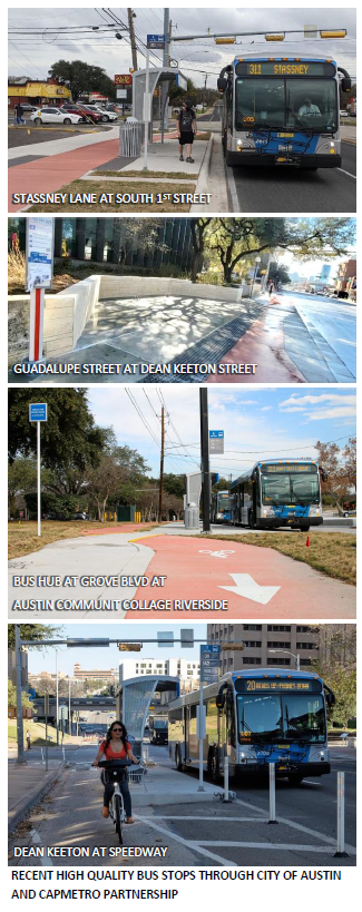
ETOD planning is in strong alignment with the strategies in this Plan and there is significant opportunity to provide support the ETOD Policy Plan goals at over 100 station pairs for rail, commuter bus, and rapid bus funded as part of Project Connect.
Note that while any of these TOD concepts are centered around a transit stop or hub they have strong alignment and relation to the 15-Minute City, and Imagine Austin Centers and Corridors concepts discussed in Chapter 1 Introduction, section Integrated Land, Affordability, Mobility, Planning for Holistic Outcomes.
TRANSIT STOP DESIGN
There has been significant evolution in the quality, multimodal design, intermodal exchange, and accessibility of transit stops including bus stops with more room for improvement.
Collaboration between CapMetro and City of Austin have identified these best practices that should be applied to any transit station design:
- Placement should be optimized for speed, reliability, and safety for transit as well as other modes.
- Located at or provide safe crossings of the street for people walking and bicycling to transit.
- Incorporate safe facilities for all travel modes and uses including separated platform area, protected bicycle lanes, and sidewalks. Integrating carefully designed bicycle facilities with the platform area prevents buses stopping in the bicycle lane requiring bus / bicycle leapfrogging that undermines all ages and abilities bikeways.
- Be comfortable for people to wait at all times of day and throughout the year including bench and shelter amenities as well as trees for shade
- Facilitate convenient intermodal exchange by providing secure bicycle and scooter parking as well as MetroBike docks as applicable. The scale of a transit stop (e.g., a light rail station compared with a local bus stop) will affect the scale and budget for the elements above but all bus stops should incorporate all elements.
TRANSIT + BICYCLE SYSTEM STRATEGIES AND ACTIONS
Strategy 2.2: Fully Integrate Cycling with Transit Services
Strategy 2.2 Indicators and Targets
- Where safe, all (100 %) Capital Metro buses, rail cars, and van pools will be able to accommodate three (3) bicycles by 2020.
- Include short and long term bicycle parking at 100 % of locations meeting transit stop bicycle parking criteria by 2025.
Strategy 2.2 Actions
2.2.1 - Coordinate with Capital Metro to provide secure and high-capacity bicycle parking (including short and long-term parking and/or covered parking, lockers, covered attended rooms) at all major transit stations, existing and future parkand- ride lots, and rail stations as they are developed.
2.2.2 - Coordinate with Capital Metro to establish criteria to identify transit stops needing short and long-term bicycle parking.
2.2.3 - Coordinate with Capital Metro to coordinate bicycle and public transportation infrastructure and services.
2.2.3a - Continue to coordinate with officials and planners of Capital Metro to ensure that all buses, commuter rail, light rail, and streetcars are connected to the bicycle network, equipped with bicycle racks, and accommodate bicycles.
2.2.3b - Require the highest level of security (Type I bicycle lockers or security guard or locked rooms) or bicycle parking spaces at large scale public transportation facilities.
2.2.3c - Coordinate with Capital Metro on grant and other funding opportunities to implement Rails with Trails projects to improve bicycle access to transit stops and stations
2.2.4 - Coordinate with Capital Metro to establish system for counting bicycles on transit ridership.
2.2.4a - Establish a system to count the number of bicycles on board transit vehicles to help assess demand for long term bicycle parking at stations.
2.2.4b - Coordinate with Capital Metro to identify ways to safely accommodate three bicycles on all or select Capital Metro buses, streetcars, and rail cars.
2.2.5 - Publicize the bicycle-transit link through events, media, and other marketing methods.
2.2.6 - Coordinate with Capital Metro to integrate bicycle route information into transit route maps and signs.
2.2.6a - Integrate bicycle route information into Capital Metro transit route maps and signs.
2.2.6b - Integrate Capital Metro transit information into City of Austin bicycle route maps.
2.2.7 - Assure the safety and efficiency of bicycles and bus transit coexistence.
2.2.7a - Continue to coordinate with Capital Metro to educate Capital Metro bus drivers about operating buses around bicycles.
2.2.7b - Educate bicyclists about proper riding techniques around buses.
2.2.7c - Consider transit/bicycle interaction in all roadway designs.
2.2.8 - Integrate Transit Service Payment, bike storage, and MetroBike payment for easy intermodal exchange.
2.2.9 – Partner with CapMetro to implement Equitable and Hybrid Transit Oriented Development land planning and strategies.
2.2.10 – Construct new bus stops to a high standard that do not generate conflicts between bicycles and buses / motor vehicles or between bicycles and pedestrians and provides easy intermodal exchange, bicycle and scooter parking, and tree shade.
METROBIKE – AUSTIN’S PUBLIC BIKE SHARE SYSTEM
Strategy 2.3: Maintain and Expand Austin’s Public Bike Share System
Public bike share systems are an important tool that provides non-owned and flexible bicycle access at low costs. Bike share systems allow users to check out public bikes to use for trips. Bike share systems are also a great low barrier [re]introduction into taking trips for bicycle that can lead to more regular bicycle use by individuals supporting mode shift goals. Austin’s public bike share system is called MetroBike, which is owned by the City of Austin and operated by a non-profit Bike Share of Austin. In 2020 Capital Metro joined the City of Austin and Bike Share of Austin as a major stakeholder in the system making it a CapMetro service and positioning it well for expansion and alignment with other transit services operated by CapMetro.
MetroBike requires a pass or membership (yearly, weekly, daily, or per ride) to gain access to the system. After gaining access, trips are free for the first 60 minutes with increased use fees for additional time. The fee structure provides both a low-cost mobility option for short trips and encourages keeping the bicycle in circulation for the next user. At the time of this plan an annual membership is very affordable compared to privately run scooters and other micromobility rental services at under $90 per year compared to scooters that typically cost $5-$15 per trip. Additionally, this plan recommends providing low-income discounts for low or no-cost annual subscriptions to remove financial barriers to this mobility service and ensuring that the service can be accessed by those who do not have a mobile phone. Bike share programs complement public transit, private vehicular transportation, and pedestrian activity by increasing mobility options available. Bike share systems are among the type of solutions that shift from dependency on private vehicle for transportation and towards more flexible and sustainable solutions. Bike sharing can also promote exercise without requiring significant lifestyle changes and the recent addition of e-Bikes into the fleet opens the service to more potential users and addresses issues of heat, distance, and hills. Bike share programs also sustain public access in an increasingly congested environment by bridging the gap between distances best served by vehicular and foot transportation. Bicycles provide on-demand transport that allows the user to reach locations not easily or efficiently accessible by other forms of transportation. In July 2020, CapMetro and the city of Austin finalized a partnership to improve Austin’s MetroBike bike share system. This partnership aims to create long-term bike share service improvements such as:
- Expanding the MetroBike fleet and stations
- Optimizing the system’s first and last mile transit solution
- Improving services and reaching communities outside of the downtown core
- Fully electrifying the MetroBike fleet For system usability and reliability, it is important that adequate resources are allocated for maintenance and operations including keeping bikes and stations in good working order, batteries charged, and bikes redistributed. Strategy 2.3 Indicators and Targets
- Expand Austin’s bike share system from 75 stations to 300 stations by 2025 and to 1000 stations by 2028.
Strategy 2.3 Actions
2.3.1 Equitably plan for and expanding the MetroBike fleet and stations.
2.3.2 Optimizing the system’s first and last mile transit solution. 2.3.3 Expand service area reaching communities outside of the downtown core, particularly in low income areas that provide access to transit.
2.3.4 Use the All Ages and Abilities Bicycle Priority Network to support locations of bike share stations to provide safe pathways for travel. 2.3.5 Fully electrify the MetroBike fleet.
2.3.6 Provide a low or no-cost subscription for people with low income.
2.3.7 Ensure that the system can be accessed by people who do not have access to a mobile phone.
2.3.8 Ensure adequate resources are allocated for maintenance and operations including keeping bikes and stations in good working order, batteries charged, and bikes redistributed. 2.3.9 Integration of MetroBike payment options with transit service and MetroBike storage shelters
2.3.10 Seek and support partnerships for the expansion of the bike share system including both capital and operations costs with Capital Metro Transportation Authority, the University of Texas, Austin Community College, State of Texas Complex, private developers, and area employers.
2.3.11 Seek grants for the expansion of the bike share system.
ELECTRIC BIKES, SCOOTERS, AND OTHER MICROMOBILITY SERVICES
Strategy 2.4: Support and manage e-bikes, scooters, and other micromobility devices and services.
Electric bicycles, scooters and other micromobility services provide increased access, flexibility, and convenience for bicycle-like mobility devices that are compatible with other users in all ages and abilities bicycle lane infrastructure. It is important that as these devices and services evolve that they operate at speeds of 20 MPH or less to ensure that bikeways remain safe for people of all ages and abilities. Access and equity to scooter and micromobility services are important considerations. While devices are typically widespread, services should be monitored and managed to ensure that these services are accessible to people across Austin. Cost is another barrier to use with trips typically costing $5-15 per trip (compared to $80 a year for MetroBike annual subscription) though the number of units and coverages of these systems is currently better than MetroBike. Over time there is an opportunity to work with service providers and shape regulations to find ways to reduce costs to users.
Strategy 2.4 Indicators and Targets
- Expand access and equity of scooter and
micromobility services.
Strategy 2.4 Actions
2.4.1 Regulate e-bikes, e-scooters, and other, electric micromobility to be compatible with all ages and abilities bicycle infrastructure including a top speed of 20 MPH.
2.4.2 Regulate parking of scooters and other micromobility services to ensure orderly and appropriate use of public right of way including but not limited to sidewalks, bicycle lanes and streets.
2.4.3 Explore ways to work with service providers to reduce costs for micromobility users.
2.4.3 Explore ways to work with service providers to educate and enforce safe riding practices by users.
RIDESHARING SERVICES AND CAR SHARE PROGRAMS
Rideshare and car share services add flexibility in mobility systems and can support shifts to more walking and bicycling. People who are able access these services can make unexpected or longer distance trips if transit does not support the travel need and if they don’t have access car. For some individuals occasional access to these services might enable them to reduce the number of motor vehicles in their household.
It is important to acknowledge that micromobility and ridesharing services are not available to everyone. These services require smartphones, data plans, and bank accounts. Lastly it is important that use of these services not undermine transit service and the strategies articulated in this plan to support and feed transit systems with bicycle networks and progressive land planning practices.
END-OF-TRIP FACILITIES
Strategy 2.5: Provide Comprehensive End of- Trip Facilities
The availability of end-of-trip facilities has the power to influence an individual’s decision of whether to commute by bicycle. A review of best practices indicates that among other things, the lack of facilities including bicycle parking, showers, and locker rooms at work significantly deters bicycle commuting. While the quality of onstreet and off-street bicycle facilities tends to be the most significant factor in a person’s choice to make a trip by bicycle, end-of-use facilities also play a significant role.
Additional end-of-trip facilities include changing facilities, car-sharing, and repair services and are all elements that improve the overall system and make bicycling easier and attractive for more people. The City Code requirements should be reviewed and amended to facilitate the accommodation of bicycle end-use facilities.
BICYCLE PARKING
Bicycle parking is an integral part of comprehensive bicycle planning. It’s not enough to develop and maintain a bicycle friendly road system. People can’t be expected to use their bicycles for transportation unless secure bicycle parking facilities exist at their destinations. Bicycle parking facilities can help reduce bicycle thefts, legitimize bicycle use, and often provide protection from the elements. Chapter 25-6 of the City Code describes off street parking requirements for bicycles. Bicycle parking requirements are based on land use classification and the number of motor vehicle spaces required. (See § 25-6- 476, § 25-6-477, and Appendix A of Chapter 25-6, Article 7.) Bicycle parking design standards are a component of the Austin Transportation Criteria Manual. Long-term parking is meant to accommodate cyclists who are expected to park for longer than two hours, such as employees, students, residents, and commuters. Long-term parking is typically located at schools, multi-family residential units, employment centers, airports, and transit hubs. It is particularly important to retrofit secure long-term bicycle parking at older apartments, particularly in lower income areas.
Safety from theft and vandalism, protection from the elements and accessibility are key issues for long term parking. A place to store accessories is also highly desired. Employers should consider providing showers and changing rooms in addition to secure parking.
The best type of parking facilities for longterm parking are either inside a building, office, guarded enclosure, or bicycle
lockers. Bicycle lockers can be installed indoors or out. They are best provided on a user-application or lease basis to ensure appropriate use. Bicycle rooms are another solution and can be created from any locked room. In locations without available indoor storage areas, or room for lockers, bicycle cages may be constructed by enclosing bicycle racks and aisle space with heavy gauge fencing and controlling access by lock. Methods of Providing Long-Term Bicycle Parking
- Install in a covered, highly visible location.
- Allow bicycles inside office buildings.
- Provide bicycle storage room inside building. Short-term parking is meant to accommodate visitors who are expected to depart within two hours. Short-term parking is typically found at retail shops and public buildings (libraries, clinics, etc.). Visibility and accessibility are key issues. Short-term parking racks should support the bicycle at two or more points above and on either side of the bicycle’s center of gravity. The best types of parking facilities for short-term storage are simple inverted- U racks. The inverted “U” rack is a single piece of heavy gauge steel bent to form a U. Pipe ends are either installed in a concrete base or have welded mounting flanges bolted directly to a solid, flat surface. Each of these racks holds two bicycles and are available commercially or easily manufactured by fence shops. Areas without space for racks can provide parking through rings holding a bicycle against a vertical wall. These rings should be attached at a height 20” above ground. Alternatively, bars may be bolted to a secure wall where conflicts with pedestrian traffic can be avoided.
Bicycle Parking in Mixed Use Developments. The environment of a mixed-use development presents an opportunity for transportation planners to plan for alternative modes, such as bicycling. With a higher propensity to use alternative modes of transportation comes the importance of implementation of supporting facilities to ensure their use. For this reason, extra attention to bicycle facilities, including the bicycle network as well as parking and other end-trip facilities is imperative to well-designed mixed-use development.
On-street bicycle parking corrals are another tool to provide high quality and visibility bicycle parking. Where on-street parking is present, a parking space can be converted to park 14 bicycles. For business owners who are interested in getting more people to their business, bicycle corrals can be a great alternative to depending solely on motor vehicle parking. To date there are 11 bicycle corrals installed throughout Austin.
SHOWER AND CHANGING FACILITIES
Showers and changing rooms in employment centers are important for bicycle transportation. These facilities benefit not only commuting cyclists, but other employees who can exercise before or after work or during lunch hours. There are very few publicly accessible shower and changing facilities (even for a fee) for bicyclists in the City. Gyms currently offer the most common and flexible option to bicyclists as they are located throughout the city. However, membership costs typically cover many more services than a person riding a bicycle simply looking for a shower and place to change is willing to pay for. The City should consider communication with area gyms and other work-out types of facilities to create bicycle commuter memberships. Several individual efforts have been made among public agencies and private developments to incorporate shower and changing facilities into developments to facilitate bicycling among their employees. The City of Austin has been active in incorporating showers and changing facilities for City employees, with nine of the City’s buildings having showers and changing facilities. Additionally, incentives exist through City administered processes such as Green Building and the site development process. The City of Austin should continue to develop improved incentive programs and requirements for showers and changing facilities in future new developments.
BIKE STATIONS
Across the United States, particularly in the West Coast, bike stations offering several services to commuters and bicyclists to support bicycling as a primary mode of transportation. While services differ at individual bike stations, typical service includes all or a combination of the following: long-term bicycle parking, bicycle repair, shower facilities and bicycle rentals. Bike stations are typically located near major public transit stations and where demand for bicycle services is high, such as in high density areas or university campuses.
With the implementation of Project Connect’s major transit stations there may be locations where this type of service would support trip shifts to bicycle or bicycle + transit. We should be careful to consider who these services benefit given that these facilities are largely oriented towards work commuters and if they justify their costs. Another aspect to consider is if large scale and modern bike share systems and the availability of e-bikes change the demand for these types of facilities.
END-OF-TRIP FACILITIES STRATEGIES AND ACTIONS IN REVIEW
Strategy 2.5 Indicators and Targets
- Reinstate a bicycle rack program or fund a public/private partnership to provide 500 new short-term bicycle parking spaces per year installed on the right-of way or private property serving existing developments.
- Provide long-term bicycle parking at Austin Bergstrom International Airport by 2024.
- Establish incentive or rebates for secure ground accessible bike parking rooms or cages and showers in existing multifamily residential and office uses by 2025.
Strategy 2.5 Actions
2.5.1 - Increase bicycle parking throughout the city.
2.5.1a - Establish a methodology for determining bicycle parking demand.
2.5.1b - Provide or increase short term bicycle parking at all City of Austin buildings, parks, and libraries.
2.5.1c - Provide or increase appropriate types of bicycle parking at all existing developments, apartments (particularly low-income), employment centers, schools, parks and recreational areas, and government offices.
2.4.1d - Review, and if necessary, enhance requirements or incentives for bicycle parking in all private or public parking structures.
2.4.1e - Work with stakeholders to determine how bicycle parking can be improved throughout the city and make improvements.
2.4.1f - Develop criteria for consistent interpretation of City Code section 25-6- 477 related to the required location of bicycle parking.
2.4.2 - Reinstate a bicycle rack program or fund a public/private partnership to install short-term bicycle parking in the right-ofway or on private property serving existing developments until demand ceases.
2.4.3 - Require that special events expecting over 1,000 attendees provide secure, affordable, and convenient bicycle parking.
2.4.4 - Require shower, locker facilities and ground floor secure long-term bicycle parking in new office developments or redevelopments.
2.4.5 - Create further and/or improved incentives to encourage existing sites to provide showers, changing facilities, lockers, and bicycle parking, including secure bicycle parking rooms and or cages above any existing or proposed minimum requirements or to retrofit existing buildings.
2.4.5a - Coordinate with Austin Energy, or other relevant Department(s), to provide rebates to commercial property owners to install shower and locker facilities in existing buildings having
none.
2.4.5b - Revise the Land Development Code and associated regulations to enable the conversion of existing motor vehicle parking to secure bicycle parking for existing sites
2.4.6 - Work with local gyms and similar types of facilities to provide shower and locker facilities to bicyclists, at a reduced charge.
2.4.7 – Conduct a business survey wherein companies provide information on shower facilities and compatibility with public use of those facilities.
2.4.8 – Establish incentives for broader public use of existing shower facilities.
2.4.9 - Establish incentives to encourage the development of additional end of trip bike stations at key locations throughout the City of Austin.
2.4.10 - Explore possibilities to work with parking garage operators to allow overnight automobile parking for multiple consecutive days.
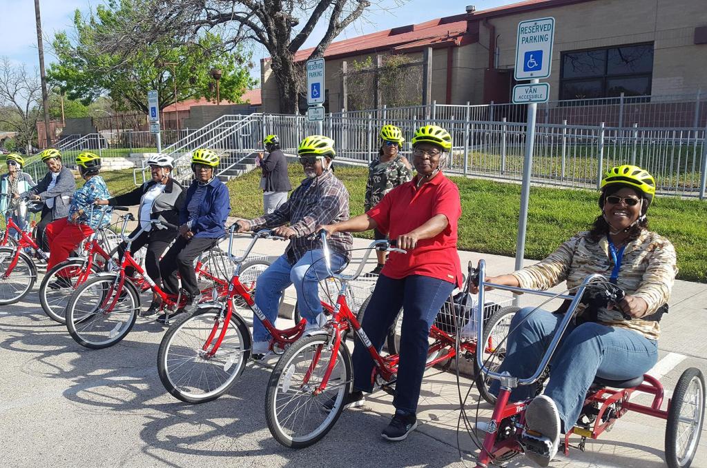
CHAPTER THREE | PROGRAMS
While an all-ages and abilities bicycle network is the foundation for increasing bicycle use and creating safer streets, programming is necessary to make the highest use of the infrastructure. Programs that deliver education, encouragement, and enforcement are all integral parts of creating a safer environment for all transportation users and obtaining the most use of the investment in infrastructure. Bicycle, multimodal and safety programs should broadly reach the general population and recognize that many different audiences should be specifically tailored to. Programs will have to effectively children, adults, older adults, motor vehicle drivers, employers, employees, people of different races and cultures, people who speak different languages, and people of different incomes and available time. Programs should be equity centered and give special focus to populations with less resources including people who have low income, people of color, and the unhoused. The following sections describe the broad groups of programs that support bicycle use.
COMMUNITY TRUST AND RELATIONSHIP BUILDING
Strategy 3.1: Build strong and lasting relationships with community leaders to build trust and solve problems together.
Current engagement approaches by the City fall short in many cases of being truly collaborative from the ground up.
City staff often ask community members to review or react to a project proposal, or for more complex projects have a listening session to gather information on needs along a street. Even with the best intentions and responsiveness from staff to address concerns this traditional approach is not enough for communities that have been historically marginalized and disenfranchised to trust the City. An alternative model is necessary to identify needs, opportunities, and pathways forward through a truly collaborative process between community members (who bring lived experiences, issues, solutions, and creativity) and city staff (who bring technical knowledge, tools, and resources). Only through repeated opportunities to build trust will strong trust and relationships be built. One promising development through this planning process was working with the plan’s community ambassadors that served as liaisons between members of the community and the planning team. The ambassadors were instrumental in meeting the equity-centered intentions of this plan including direct outreach and conversation with focus demographics, conversations about community articulated challenges and solutions and ultimately technical review of this plan document, goals, strategies, and actions.
This plan recommends the establishment of an ongoing Community Ambassador Program to support plan implementation
and project and program development. There are many exciting trust-building, engaging, fun and productive ways that community ambassadors could work in partnership with community members and city-staff including:
- On-going dialogue with community leaders and city-staff facilitating two way information flow regarding needs, challenges, tools, solutions, partnerships, resources available, etc.
- Bicycle rides and walks with community leaders to understand problem areas and opportunities.
- Helping to address issues of access to community conversation and public engagement efforts due to time availability, work schedules / multiple jobs, digital access barriers, childcare needs, etc.
- Helping to meet engagement goals relative to community demographics around implementation areas for projects, programs, and planning.
- Meeting people where they are to gather feedback, raise concerns, consider proposals, etc.
- Collaboration with the City to synthesize input from the community and develop solutions that meet community needs.
- Support encouragement and promotion programs in empowering, creative, and trust-building ways.
- Providing an institutional resource to city staff to better understand nuanced equity issues and feedback, share best practices and insights, collaboratively develop solutions, build understanding in the community, and ultimately hold the City accountable for equity centered processes and solutions.
Strategy 3.1 Indicators and Targets
- Establish a Community Ambassador Program to support Plan, project, program implementation by 2023.
Strategy 3.1 Actions
3.1.1 – Work to fund a community ambassador program from multiple programs and agencies to both increase the scale of the program and enable conversations across silos about interconnected issues and solutions including: multimodal programs, CapMetro, land planning, and affordability and anti displacement programs and tools.
3.1.2 – Utilize a community ambassador program in the trust-building, engaging, fun and productive ways inclusive of those articulated in this section to work in partnership with community members and the City.
3.1.3 – Ensure that community ambassadors’ range of compensation is commensurate with their individual professionalism, lived experience, training and education (both informal and formal), and skill sets brought to the program.
3.1.4 – Explore other complementary approaches beyond community ambassadors to identify issues, find solutions, and build trust with the community prioritizing focus populations.
ENABLEMENT PROGRAMS
Strategy 3.2: Provide enablement programs that support the needs of people to transition to bicycle.
There is a need for programs that provide resources that enable people to overcome financial barriers to using bicycles and scooters for transportation. Non-profits such as Yellow Bike Project and Ghisallo Cycling Initiative provide support for low-cost or donated bicycles and training to reduce maintenance costs. There is also a need for broader availability of regular bike clinics for tune-ups, minor repairs, and skill sharing. There are also models of successful bicycle donation programs where training, locks, lights, and cargo bags are provided in addition to bicycles.
There are opportunities to expand or enhance city programs and partnerships with non-profits or bike shops. There is a possibility of working with local bike shops to have vouchers to reduce the cost of maintenance for traditional and electric bicycles.
The Electric Ride Rebate Program discussed in the next section helps with the financial barrier of e-bikes, scooters, mopeds, and motorcycles. Current City rebates limited to electric bicycles, scooters, mopeds, and motorcycles could be extended to nonelectric bicycles (beyond batteries).
AFFORDABLE ACCESS TO ELECTRIC BICYLCES, SCOOTERS AND REPAIR
Austin Energy recently expanded its rebate program for electric bicycles, scooters, mopeds, and motorcycles. The new rebate doubled the prior rebate (up to $600 off a $2,000 electric bicycle) and added a lowincome rebate (up to $1300 off a $2000 electric bicycle). More details can be found on Austin Energy’s Electric Ride program page.
This plan recommends helping with electric bicycle adoption through this rebate program and monitoring rebate levels for desired outcomes. This plan also recommends proactive outreach to make low-income communities aware of the program and additional rebates for low income residents.
This plan also recommends exploring assistance to overcome any financial barriers to electric bicycles that have higher maintenance needs than traditional bicycles.
Strategy 3.2 Indicators and Targets
- Grow the electric bike rebate program to over 5,000 rebates annually.
- Partner to provide 5,000 donated or subsidized bicycles annually.
- Partner to provide 100 bicycle repair clinics annually, focused on low-income neighborhoods.
Strategy 3.2 Actions
3.2.1 – Provide support for rebates or donated bicycles to low-income individuals.
3.2.1a – Create partnerships with nonprofit groups to provide people with low cost or donated bicycles.
3.2.1b – Create partnerships to provide “create a commuter” / “create a confident rider” type programs where training, locks, lights, and cargo bags are provided in addition to bicycles.
3.2.2 – Provide support for bicycle repair needs, particularly for low-income individuals.
3.2.2a – Create partnerships with nonprofit groups to provide regular bike repair maintenance clinics or bicycle repair skills training.
3.2.3 – Extend electric bicycle rebate program to electric scooters.
3.2.1a – Explore free or reduced cost scooter passes for low-income residents.
3.2.4 – Partner with bicycle shops to provide bicycle repair vouchers for low income residents for regular and electric bicycles.
PROMOTION AND ENCOURAGEMENT
Strategy 3.3a: Develop and execute encouragement programs to promote bicycling and increase awareness of bicycling among the public.
Strategy 3.3b: Partner to create citywide multi-modal encouragement and educational programs targeting reduction in drive alone trips.
Encouraging and promoting bicycle riding is necessary for getting people over personal psychological barriers and excited about bicycling. Encouragement programs can get
people the information and nudge they need to break deeply seeded habits that keep them from trying a trip by bicycle for the first time.
Austin is in the middle of a rapid expansion of the mobility options and would benefit from the continued use of multi-modal encouragement programs like the Smart Trips Program. A partnership between the City of Austin, Capital Metro, Movability Austin, Car2go, Zipcar, MetroBike, Carma ride sharing, and other mobility providers can significantly increase the use of rail, bus, bike sharing, bicycling, walking, car sharing, carpooling, and other mobility options. The success of this type of program in increasing bicycling lies in its ability to help people find bicycle routes and discuss parking, showers, and changing facilities to alleviate apprehensions about bicycling and similar issues for getting around by transit, walking, and other ways. The confidence building personal touch that this program gives results in successful behavior change. In Portland, Oregon where the program was developed, they were successful in reaching 20,000 households a year within a geographic area and reducing drive alone trips by 9-13%. The cost of their program was approximately $10 per person with a total cost of $570,000 per year which results in a strong return on investment to shift travel behavior.
Promotion aims to increase bicycling through marketing, advertising, and incentives. Currently, the City of Austin provides modest programming to promote travel options. Get There ATX is the City’s current program to provide resources on mobility options. Promotional efforts are also done by non-City groups. It is recommended that the City increase resources and partnerships to promote bicycling and other modes of transportation.
Ciclovia events (previously called Viva Streets in Austin), where miles of streets are made car-free for the day, are incredible means of promoting the
transformation of public space, walking, bicycling, and active, healthy living. Austin has hosted only a limited number and scale of these events. This program’s potential remains untapped compared to Ciclovia’s held in other cities, most notably Bogota, Columbia. The plan recommends that these events be expanded in frequency, geographic diversity, and total length of street closure to extend the reach and effectiveness of these events in Austin. Events where the City of Austin partners with groups to promote National Bike
Month and associated activities are great ways to encourage cycling. Events such as Social Rides; “Longhorn Bike Day”; “Bike to your Neighborhood Pool Day”; mountain
bike, urban, and natural-surface trail rides
are other influential promotional events.
Promotion increases awareness of the benefits of bicycling to the public. They can also target particular audiences. For example, a person who commutes to work from 20 miles away may not be encouraged to commute by bicycle but may be prompted to start bicycling for recreational purposes to improve health or to make short trips on the weekend or evening by bike. Partnering with other public agencies, non-profit groups, community ambassador programs, and private sector groups will result in more diverse, lower-cost, and influential promotional efforts.
Promoting bicycling to work is a common practice as commuting is a daily trip, driving contributes to congestion and bicycling is an opportunity to integrate physical activity into a busy workday. Events such as bike-to work day and programs such as commuter cash incentives are effective ways to increase bicycling to work.
As one of largest employers, the City of Austin has an opportunity to set an example to promote bicycling among its workforce to other employers and public agencies. Examples include hosting bicycle classes through its Physical Education (PE) Program, providing free bicycle maintenance and repair classes, and stand-alone safety classes, providing secure bicycle parking
rooms and hosting annual department director-led rides to celebrate new bicycle infrastructure. The City also provides free yearly memberships to MetroBike for employees.
Another encouragement opportunity is leveraging and building support for recreational cycling activities such as mountain biking, road racing, road touring, BMX, gravel, cyclocross, bicycle polo, social cycling. Building appropriate cycling facilities such as mountain bike optimized natural surface trails; BMX dirt jump and concrete parks; child-oriented "bike playgrounds" and "traffic gardens", etc. is an important part of building and supporting a culture of cycling.
Strategy 3.3 Indicators and Targets
- Reach 20,000 households a year through a Smart Trips or travel options type program.
- Reduce drive alone trips by 10% in areas after deployment of Smart Trips or travel options type program.
- Create partnerships with other public agencies, and/or non-profit groups and advocacy groups to reach tens of thousands of people per year with promotional programs.
- Host 5 Ciclovia events per year serving geographically diverse parts of the City by 2026 and 20 a year by 2028.
- Notify the public of and engage residents in all phases of new infrastructure projects and programs through the City’s website and other communication means.
- Increase number of City of Austin employees who commute to central city locations by bicycle to 7% by 2025 and 10% by 2028.
Strategy 3.3 Actions 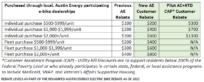
3.3.1 - Implement a Smart Trips or travel options type program.
3.3.1a - Conduct ongoing evaluation of the program, and if successful, expand with a goal of strategically scaling the program to optimal levels considering demand, equity support areas, opportunity areas, or targeting people who have recently moved to a new neighborhood.
3.3.2 - Partner with community groups, the private sector, and other City departments and agencies to provide citywide events and campaigns, such as National Bike Month
3.3.3 - Expand the Viva Streets (Ciclovías or Open Streets) program 5 events a year serving geographically diverse parts of the City by 2025.
3.3.4 - Utilize a variety of methods to distribute and market promotional information.
3.3.5 - Partner with local celebrities and organizations to promote bicycling through public service announcements and other means.
3.3.6 - Bicycle Program staff should host a regular TV, radio, and/or print section, preferably for a mainstream channel or publication regarding bicycling promotion and education.
3.3.7 - Work with local retail bicycle dealers to create a “Take your bike to the shop today” program offering special incentives to get bikes out of the garage and ready to ride safely.
3.3.8 - Promote a pilot “Bicycle Ambassador” program that utilizes a volunteer force to conduct promotional outreach at events and other forums.
3.3.9 - Promote bicycling to work.
3.3.9a - Develop and deploy incentive programs to encourage individuals to commute to work by bicycle.
3.3.9b - Work with employers to promote bicycling as a means of commuting to work.
3.3.9c - Promote Bike to Work Day and Bike Month in May.
3.3.9d - Support Bicycle Commuter Services and Escorted Commute Rides offered by local bicycle shops and bicycle advocacy groups.
3.3.10 - Promote bicycle use for employees who work for the City to serve as a model program for other Austin employers including public agencies.
3.3.10a - All City-owned buildings should be retrofitted with showers, changing rooms, lockers, and secure bicycle parking to facilitate bicycle use among employees.
3.3.10b - Switch to a parking payout program to give cash incentive to employees to commute by means other than the private car to decouple parking costs.
3.3.11 – Ensure programs are centered in equity understanding the needs of local communities. This can include providing translated materials, interpretation at events, identifying local needs and build trust through tailoring programs to those needs, having community ambassador support for program-based activities, and other best practice approaches.
3.3.12 - Partner with other departments and local organizations to develop education and encouragement programs for populations historically underrepresented in bicycle programs,
including people of color, people with low income, young people, older adults, and people who identify as LGBTQIA+.
3.3.13 - Collaborate with community leaders, neighborhood groups and other partners who want to promote and improve bicycling and bicycle safety through neighborhoods and city events.
3.3.14 – Support recreational cycling opportunities and related tailored cycling facilities.
3.3.15 – Ensure language accessibility of these programs.
PROMOTION OF BICYCLING TO SCHOOL
Strategy 3.4: Promote bicycling to school (elementary through high school).
Safety education and encouragement programs for school-aged kids are particularly important as many students need outlets for daily physical activity.
Giving them the skills to bicycle will help them form lifelong habits, creating the next generation of people on bikes. Additionally, school- related traffic is a significant source of congestion on our roadways and creates unsafe conditions around schools. To break the cycle of concern for walking and bicycling safety around schools, a deliberate program of infrastructure, education and encouragement must be implemented.
There is much opportunity to further promote bicycling to all school- age children. Students, families, and school staff all need more resources to increase bicycling use at schools. High schools are particularly underserved at this time and need attention. These educational and promotional efforts will support the City’s investment in an all-ages and abilities priority network. The combined infrastructure and program efforts will significantly increase ridership to schools and healthier and more engaged students. Several successful programs are already in place and should be supported and expanded. The City of Austin's Safe Routes to School Program creates a safe environment for students as they travel to and from school. The program includes over 200 crossing guards at 100 elementary schools in seven school districts within the City. Training staff educates over 50,000 students in safe street crossing procedures for walking and bicycling. In class, the bike training for students teaches the rules of the road for our young bike riders. The students then practice what they have learned in the classroom at hands-on training events, called "bike rodeos," after school or on weekends. The program works closely with the school’s community and neighborhood groups to encourage the use of active transportation options to travel to and from school instead of using motor vehicles.
Another past successful program is the Boltage Program, which offers an incentive to students to ride to school daily. The program was in place at several schools between 2011 and 2014. The program utilizes a sensor near the school bike rack that detects a transmitter in the child’s helmet, recording how many days kids ride to school. Prizes are given out at the end of the year for participants who ride a certain number of days throughout the year, which resulted in a significant growth in bicycling at these schools.
Other school aged education and encouragement strategies can help motivate young children to ride to school such as utilizing “mock street” learning facilities or bicycle recreational or social opportunities such as skills parks, pump tracks, and bike school buses.
Another opportunity is promoting bicycle use for students, faculty, and staff at universities within Austin. Explore partnerships with universities to support bicycle use for this significant population in Austin.
Strategy 3.4 Indicators and Targets
- Increase bicycle mode share of children commuting to school to 25% by 2028.
- Provide bicycle education and encouragement programs to 90% of children before high school.
- Conduct safe biking and safe walking encouragement & messaging to school aged children.
- Provide encouragement and educational outreach to all students, parents, and staff at schools served by new or improved bicycle facilities.
- Establish Bike Train (or Bike Bus) initiatives in at least 10 schools holding regular rides by 2024.
Strategy 3.4 Actions
3.4.1 - Continue and expand safety and encouragement programs for school aged children to increase walking and bicycling to school.
3.4.2 – Support and encourage “bike train” / “bike bus” type programs for kids getting to school in fun ways and engaging ways and providing safety in numbers.
3.4.3 - Install supporting bicycle infrastructure that extends the All Ages and Abilities Bicycle Network to schools.
3.4.4 - Partner to create ride-to-school encouragement programs, such as “Bicycle to School Day.
3.4.5 - Support and encourage high school bicycling clubs that include activities for both utilitarian, recreational, competitive bicyclists (such as National Interscholastic Cycling Association (NICA) affiliated programs).
3.4.6 - Support innovative and new programs and/or events which aim to increase bicycling to school.
3.4.7 – Explore partnerships with universities within Austin to promote bicycle use for students, faculty, and staff.
3.4.8 – Support building facilities for cycling at schools, in the form of bicycle playgrounds, traffic gardens, pump tracks, and skills parks, particularly at campuses partnered with PARD that could be open to the public to both teach and excite students about cycling.
BICYCLING AND SAFETY EDUCATION 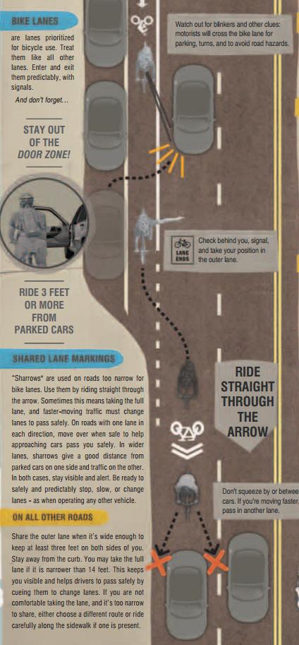
Strategy 3.5: Develop and execute programs to improve bicycle safety and roadway behavior.
Educations programs are a great tool to create safer conditions for all roadway users. While people who bicycle can benefit from learning how to ride more safely, people who drive, walk, and take transit should understand how to interact with people on bicycles to improve safety and coexistence on the roads, sidewalks, and trails. Education programs are delivered through two primary means: public outreach and education classes.
Just as we provide training for drivers of motor vehicles, we must inform bicyclists of their rights on the road and how to ride safely. While many bicyclists know how to ride a bicycle, they do not necessarily know how to ride in traffic. Bicycle skills courses can give bicyclists the confidence and tools to ride safely.
Providing bicycle education for young children is critical because they have little to no experience making decisions in traffic, depend on bikes for transportation, and
through teaching children, we can affect parents’ behavior. The City of Austin educates school-aged children on bicycling and walking to school through the Safe Routes to School Program. These programs are discussed in more detail in Strategy 3.3.
It is also important to educate motor vehicle drivers on the needs and rights of bicyclists, as they differ considerably from other road users. Integrating bicycle perspectives and content in general motor vehicle diver safety training is traditionally underrepresented but is essential to encourage more positive interactions between bicyclists and motor vehicle drivers on the road.
For the public, there is a market for bicycle safety courses taught by both businesses and non-profits. Unfortunately, the cost of these classes keeps exposure to the general population limited. The Plan recommends providing low-cost or free educational classes to the public through City programming or partnerships with organizations to advance educational goals. Bicycle education classes can also be offered through employers such as the City of Austin’s Health PLUS Wellness Program and PE Program, which offers bicycle safety courses.
Strategy 3.5 Indicators and Targets
- Distribute 5,000 Austin Bicycle Map Brochures to motorists and bicyclists per year.
- Educate 1,000 adult bicyclists and motorists about bicycle and motorist safety each year.
Strategy 3.5 Actions
3.5.1 - Partner with community organizations and bicycle advocacy groups to offer educational classes.
3.5.1a - Coordinate community requests for bicycle education with experienced bicycle educators in the community.
3.5.1b - Encourage community organizations and school programs to offer on-bicycle training as part of their curriculum.
3.5.1c - Offer bicycle education and safety courses free to City employees.
3.5.2 - Create and provide educational programs targeting youth cyclists.
3.5.2a - Support the Safe Routes to School Program.
3.5.2b - Work with Parks and Recreation, Austin Public Health, Library, and other Departments to educate children on the health and environmental benefits of bicycling and develop ride, navigation, and bike repair skills.
3.5.2c - Develop a bicycle safety component for high school driver education programs.
3.5.2d - Provide bicycle safety and bicycle rider training to schools served by a new bicycle facility installation.
3.5.3 - Create and provide educational programs targeting adult cyclists.
3.5.3a - Provide or partner to provide bicycle-related classes such as repair and maintenance, effective bicycling skills, rules of the road, etc., such as “Traffic Skills 10I” at a low cost to the public.
3.5.3b - Support efforts among other city departments, public agencies, and bicycle organizations to offer bicycle related classes.
3.5.4 - Create and provide educational programs targeting motorists.
3.5.4a - Create and distribute informational material targeting motorists regarding bicyclists’ rights and how to safely share the road and benefits of roadways that are safe for everyone.
3.5.4b - Provide information related to updating the Texas drivers’ manual to strengthen the bicycle section and exam questions.
3.5.4c - Include motorist-bicyclist safety information in City required defensive driving courses.
3.5.4d - Train/educate drivers of commercial vehicles about bicycle safety and sharing the road with bicyclists.
3.5.5 - Create partnerships to conduct educational campaigns.
3.5.5a - Utilize a variety of methods to distribute and market educational information more effectively and at a lower cost. This includes various advertising means, partnerships, and presence at events.
3.5.5b - Strengthen the “Share the Road” and develop a “Share the Trail” public awareness campaign.
3.5.5c - Encourage the use of helmets through educational programming and campaigns and provide free or low cost helmets to low income individuals.
3.5.6 - Expand Distribution of Austin’s Bicycle Map and provide wayfinding guidance along the bicycle network.
3.5.6a - Regularly update and widely distribute the Austin Bicycle Map.
3.5.6b – Publish and maintain an online bicycle map.
3.5.6c - Improve and expand upon a comprehensive citywide signing system to clearly indicate bicycle routes and multi-use paths.
3.5.6d - Display bicycle route system maps and information at key locations / destinations like downtown, activity centers, and transit stations.
3.5.6e - Publish GIS bicycle map and facility information to promote 3rd party solutions.
3.5.6.f - Provide wayfinding guidance along bicycle network.
3.5.7 - Develop measures to reduce bicycle theft.
3.5.7a - Educate residents on techniques that can help recover stolen bicycles.
3.5.7b - Educate bicyclists on proper locking techniques.
3.5.8 - Coordinate traffic safety education & enforcement campaigns with applicable City and community partners in ways that prevent racial, class based or modal profiling
3.5.9 - Encourage and promote the use of the City 311 system specific to bicyclists’ issues.
3.5.10 - Hire staff to specifically focus on educational and promotional programs.
3.5.11 – Ensure language accessibility of these programs.
ENFORCEMENT AND BICYCLE LAWS
Strategy 3.6 – Carefully and appropriately use public educational enforcement approaches to support the shift away from unsafe, inconsiderate, life-threatening roadway behavior and dangerous crash patterns in ways that ensure that racial, socioeconomic, or modal profiling and unintended consequences do not occur.
The design of our streets; our population’s habits and behaviors; the number of people driving vehicles vs. walking, bicycling, and taking transit; program and educational
approaches; and traffic laws and the enforcement of those laws all play a role in whether we will be able to successfully build a culture of safety, respect, and inclusion on our streets.
Public education-oriented enforcement programs are a tool that can help shape public habits and behaviors, but it is critical it is done in ways that ensure that racial, socioeconomic, or modal profiling and unintended consequences do not occur. The careful design of streets using a Safe Systems Approach has been shown as the most effective avenue to creating
self-enforcing safe streets with fewer life altering crashes. Law enforcement of traffic laws should be used on a limited basis and very carefully to ensure that racial, socioeconomic, or modal profiling does not occur.
There are perceptions among some drivers that people who ride bicycles flagrantly do not follow the law, which leads to calls for stronger enforcement. Bicycles are legal
vehicles in the State of Texas, and people riding a bicycle are required to follow all the rules and regulations applicable to all vehicles, with only minor differences. As with all modes of travel there is a minority of street users who are flagrantly unsafe and disrespectful on the road.
Bicyclists report that car drivers sometimes go out of their way to intimidate them by driving too close, throwing objects, blowing their horns, and generally harassing them. This type of behavior should be taken seriously.
Drivers should ultimately be held accountable for the risks that their vehicle’s mass, speed, and use bring vulnerable users of the road and vehicles should be considered weapons if used improperly.
Motorists also speed, text and use mobile phone apps, roll through stop signs, run red lights, fail to yield, and exhibit other unlawful behaviors that are dangerous to bicyclists and other roadway users. The numerous stories of hit-and-runs where the person on a bicycle is left for dead by a negligent motorist are egregious and unlawful behaviors that sadly continue to happen.
Beyond providing safe self-enforcing infrastructure, the highest enforcement priorities are enforcing driver speed, distraction, and impairment laws. Speed is often considered a law to be mildly disregarded, but is a significant factor in negative crash outcomes and Speed Management is a major focus of the Vision Zero Program. Use of automated speed enforcement, while not currently allowed by the State, is a powerful tool and international best practice that should be pursued. Distraction and impairment carry high risks and compound with speed for worse crash outcomes.
Beyond safe systems approaches it is important to note the need or lack of need of enforcement in relation to other systems . Imagine if people could reliably take buses
home from bars because they ran at all hours and had enough routes, sidewalks, lighting to get home safely and conveniently.
Austin already has ordinances banning texting (and smart phone use) while driving, which should be enforced with a no tolerance policy as it has been shown to be more dangerous than drinking and driving. Lastly, drug and alcohol impairment must be taken more seriously through enforcement and the consequences of being caught driving.
The lack of adequate bicycle facilities may also contribute to unlawful actions by bicyclists. Often traffic signals fail to detect and change for bicyclists, resulting in bicyclists running a red light. In many situations, bicyclists operating on inadequate facilities face harassment and intimidation from inconsiderate and uneducated motorists who do not understand the needs of bicyclists or how to share the road properly.
The Bright Lights program previously implemented by the City of Austin gave warnings along with lights for violation of the law. This was a great way to help address safety issues with people riding bicycles without safe and legal levels of lighting. This should be implemented in parallel to other enablement and encouragement program efforts where lights are distributed at popup events, public meetings, and by community ambassadors, particularly in low income areas.
Chapter 525 of the Texas Transportation Code requires that the Department of Public Safety include bicycle awareness information in any edition of the Texas drivers’ handbook (Texas Transportation Code, Statute 525.001). Chapter 9 of the Texas Drivers’ Handbook addresses vehicular sharing of the road with bicycles; Chapter 13 addresses bicycle vehicle laws and safety; and Chapter 15 addresses safe passing of bicycles by commercial vehicles. Continuing to revise the Texas Drivers’ Handbook with the most current and best practices of bicycle safety will ensure consistent education of motorists and bicyclists, enforcement of these laws, and improvement for safety of bicyclists on the road.
Strategy 3.6 Indicators and Targets
- Decrease of unsafe, inconsiderate, life threatening roadway behavior and dangerous crash patterns every year, in conjunction with other approaches (safe systems design, public information campaigns, etc.), through support from careful and appropriate use public educational enforcement efforts in ways that ensure that racial, socioeconomic, or modal profiling and unintended consequences do not occur.
- Conduct ongoing monitoring and oversight of this program approach to ensure that all goals are met without unintended consequences.
Strategy 3.6 Actions
3.6.1 – Use limited and strategic enforcement of traffic laws for priority
unsafe roadway habits and behaviors that affect public safety coupled with educational campaigns while ensuring that racial and socioeconomic profiling and unintended consequences do not occur.
3.6.1a - Further promote safe and considerate behavior and traffic laws through education. (See Promotion and Encouragement and Bicycling and Safety Education).
3.6.1a – Carefully consider the equity implications of enforcement efforts intended to create behavior change including race-based risks of interactions with police officers. Also consider
inequities in fine based systems based on a person’s income (some have enough money to break the law with little consequence) and alternatives like warning tickets and publicity of targeted campaigns to shift broader behavior.
3.6.1a – Support wider use of automated enforcement for speed and red-light running infractions to address high risk behaviors without increasing the risk of profiling.
3.6.2 - Support and monitor efforts to update the State drivers’ manual to strengthen bicycle section and exam questions.
3.6.3 - Amend City of Austin Defensive Driving Course curriculum to include motorist-bicyclist safety information and support any State or other agency efforts to do the same.
3.6.4 - Expand a bicycle education course for bicyclists cited for traffic violations, to take in lieu of a fine, or offer defensive driver courses revised to include bicycle use in traffic instead of a new course.
3.6.5 - Partner to create a mandatory cyclist awareness educational course for motorists that receive citations involving cyclists.
3.6.6 - Find means of providing responsive city-wide enforcement of parking in bicycle lanes.
3.6.6 – Reestablish the Bright Lights program that gives warnings along with lights for violation of the law in conjunction with other enablement and encouragement programs that distribute lights.
BEST PRACTICE REGULATIONS AND CONSISTENCY IN ENFORCEMENT
Strategy 3.6a: Ensure best practice roadway safety related laws are in place.
Strategy 3.6b: Ensure consistent interpretation and enforcement of roadways safety related laws by Austin Police Department in ways that ensures racial, socio economic, or modal profiling does not occur.
It is important to have both best practice roadway safety laws and consistent enforcement to create a culture of safe and respectful interactions between road users and support of multimodal goals. This alignment will also create a partnership and mutual respect between all roadway users and law enforcement agencies. Bicycle-friendly laws that have been implemented in other cities include stiff penalties for negligently opening a car door into the path of a cyclist. Another good example is the “Idaho stop” law allows a bicyclist to treat a stop sign as a yield sign. Therefore, rather than being required to come to a stop, the bicyclist is required to slow down, stop if required for safety, and yield the right of way to any approaching vehicle or pedestrian before proceeding through an intersection controlled by a stop sign. It is called an “Idaho stop” because it has been the law in Idaho since 1982 but may also be referred to as a “stop-as-yield” or “yield-stop” law. There are also red light laws that allow people on bicycles to stop and if safe (or the signal detection does not work for the bicycle), to proceed through the intersection. This is a good example of law that better aligns with the nature of bicycling as human form of transportation and being much safer to others than risks posed by driving. Enforcement should be consistently and fairly applied to all roadway users. This goal can be achieved through reviewing law enforcement policies and data reporting while maintaining an ongoing dialogue and partnership with law enforcement agencies. Local laws should be interpreted consistently so that neither law enforcers nor users of the road (motorists and bicyclists) will be confused about legal behavior. Educational materials should be consistent with state and local traffic laws, which should also reflect the best practice regulations around the country. Currently, the Austin Police Department (APD) includes bicycle law enforcement training in the Cadet Academy. Continuing to train law enforcement officers on roadway safety and bicycle issues will help ensure consistent enforcement of the laws protecting people who bicycle. The Transportation and Public Works Department will work with APD to unify traffic laws and enforcement policies and ensure consistent interpretation by officers.
Strategy 3.6 Indicators and Targets
- Evaluate bicycle laws every 2 years and work with APD and City prosecutors to bring them up to national best practice.
- Train 100% of APD law enforcement officers in bicyclist and motorist behavior laws and bicycle issues in conjunction with the City Bicycle Program.
Strategy 3.6 Actions
3.6.1 - Clarify state laws and the City of Austin’s traffic codes and amend where necessary to improve safety for all roadway users.
3.6.1a - Clarify legal status of bicycles as vehicles, with all rights to use the roadway.
3.6.1b – Clarify legal riding position in bicycle lanes, protected bicycle lanes, protected intersections (including allowable turning movements), on sidewalks, shared use paths, on the roadway (riding 2 abreast), etc.
3.6.1c - Evaluate roadway safety laws every 2 years and work with APD and City prosecutors to bring them up to national best practice
3.6.1c – Support the adoption of the “Idaho Stop” law at the State level better align with the nature of bicycling as human form of transportation and being much safer to others than risks posed by driving.
3.6.3 - The City of Austin Bicycle Program should coordinate with APD to compile an annual report outlining data for bicyclerelated citations, 311 calls on aggressive driving, crashes, injuries, and other enforcement/safety issues to help identify specific trouble spots or behaviors by motorists and/or bicyclists that need to be corrected.
3.6.4 - Review APD Uniform Traffic & Tolerance Policy for roadway safety laws to make recommendations of changes as necessary regarding racial, class based, or modal profiling.
3.6.4a – Ensure accountability to these Uniform Traffic and Tolerance Policies.
3.6.5 - Provide bicycle educational training for all law enforcement personnel in the Austin metropolitan area.
3.6.5a - Enhance bicycling issue education within Police Training Academy curriculum.
3.6.5b - Provide that all law enforcement officers receive an annual review on bicycle behavior laws and safety issues and the current Traffic and Tolerance Policies related to roadway safety laws.
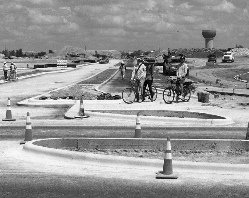
CHAPTER FOUR | IMPLEMENTATION
INTRODUCTION
Over the past five years, Austin has significantly expanded and improved the quality of the bicycle network and implemented many of the policies recommended in the 2014 Bicycle Plan. A
strategic implementation program is laid out in the 2023 Plan and is critical to ensure rapid progress towards implementation. The 2023 Bicycle Plan aligns its implementation framework with Imagine Austin’s five-points implementation approach.
PROJECT LEVEL IMPLEMENTATION
The Bicycle Plan includes recommendations based on high level planning principles such as roadway speed, volume, and desired network connectivity. The recommendations tabulated in the Plan create a starting place in the process to create Complete Streets that meet the intent of the City’s newly adopted policy and serve people on bicycles of all ages and abilities.
At the time of project implementation on a specific corridor, recommendations in this plan are tested through preliminary design,
data collection, alternatives analysis, and appropriate public process. Not all recommendations in the plan will be feasible and lower level bicycle facilities or a no build scenario may be the final outcome. Public processes will be conducted for projects that have significant impacts on the public such as the modification of onstreet parking, number of vehicle travel
lanes, or traffic calming devices. Stakeholder groups that are affected by the proposed project will be engaged such as property owners, residents, and businesses along the corridor; adjacent neighborhood associations; and the traveling public. There are currently proven processes in place that govern the implementation of parking modification, lane conversion, and traffic calming projects. At the time of writing the parking modification process has been conducted on over 115 projects totaling 80 miles of roadways and lane conversion process has been used for more than 10 projects totaling 50 miles. It is critical to the ongoing implementation of the infrastructure recommendations in the Plan to deliver projects through a
consistent, transparent and context sensitive process that is responsive to the many needs of the public and yields successful projects.
FIVE-POINT IMPLEMENTATION PROGRAM
Strategy 4.1: Strengthen and diversify implementation efforts through a fivepoint implementation program to fulfill goals and strategies of the 2023 Plan.
The five-point framework ensures a well rounded implementation approach and sets the stage for a broader and longer lasting impact. The five-points of the implementation program are as follows:
- Education and Engagement
- Internal Alignment
- Regulations
- Public Investment
- Partnerships
One of the broad themes of the five-points implementation program is to broaden the support base for bicycling. Implementing the 2023 Plan requires the coordination of all City of Austin departments, partner agencies and organizations, and the public at large. By integrating bicycling as a tool to meet the goals of groups outside of the bicycle program, a broad coalition can be built that will significantly accelerate the realization of the Plan. The five-point implementation program also brings focus to the broad range of avenues to implement the plan. While the highest priority of the plan is to implement an All Ages and Abilities Bicycle Priority Network, the realization of this goal will require more than public investment and
ultimately requires actions touching each of the five points. The same holds true for the other program and bicycle system goals in the Plan. This section will reference strategies and action items from previous chapters and demonstrate how they align with the five points implementation program. It will also spotlight implementation approaches for key strategies.
Strategy 4.1 Indicators and Targets
- Evaluate efforts towards the
implementation of the Plan every year
and include it in an annual report.
EDUCATION AND ENGAGEMENT
Strategy 4.2: Educate and engage all relevant internal and external stakeholders to support the goals and implementation
of the Plan. The Plan update represents a significant evolution in approach from the 2014 Bicycle Plan and establishes a vision to maximize the contribution of cycling in realizing our shared goals as set forth in the Imagine Austin Comprehensive Plan with a greater focus on equity. Due to this shift, education and engagement of the public at large (with a focus on communities of color, low income, unhoused, etc.), City staff, City leadership, partner agencies, and other organizations are all a top priority. This collaboration will ultimately lead to successful implementation of the plan by raising awareness, understanding, and support.
Multiple types of programs and communication need to be utilized to convey the public benefit of modal choice, bicycling and safe streets; importance of equitable outcomes; building empathy; challenging public perception and racial and economic apathy. This will build confidence both in the plan’s vision and in the City’s dedication to achieving that vision.
Strategy 4.2 Indicators and Targets
- Evaluate education and engagement efforts towards the implementation of the Plan every year and include it in an annual report.
Strategy 4.2 Actions
4.2.1 Consider commissioning innovative media / programming through grant funding for artists to commission docuseries, plays (even for kids to foster broader generational comprehension), commercials, art / poetry shows, etc. by low-income and/or BIPOC who use these infrastructures and / or have been directly affected by displacement that are equity focused, geared toward educating, challenging public perception / racial and economic apathy.
4.2.2 Educate the public about the benefits of bicycling and developments in project and programs through the following outlets:
- Program communications through website, social media, email distribution list
- Partner communications
- Event outreach
- News outlets
- Annual Reports: Bicycle Program, Transportation and Public Works Department, Imagine Austin, partner agency reports.
- Presentations to civic groups: neighborhood and business associations, schools, non-profit organizations, etc.
- Community engagement upon project delivery: mailings (email and paper notices) to stakeholders, public meetings.
4.2.3 - Continue to support and receive input and guidance from the Bicycle Advisory Council (BAC) if its membership can be made diverse and representative of diverse voices and perspectives in the community at large and have a purpose centered in equity.
4.2.4 - Continue to implement and grow education and encouragement programs for bicycling and other non-single occupancy vehicle trip options.
4.2.5 - Provide or partner to provide training to appropriate City staff, partner agency or organization staff, and private consultants.
4.2.5a - Provide training on best practice bicycle planning and facility design
4.2.5b - Train and educate transportation engineers and planners at the local, regional, and state levels about the needs of bicyclists.
4.2.5c - Train relevant City of Austin staff about implementation of this Plan.
4.2.5d - Develop and provide training for various parties responsible for carrying out any part of this Plan.
4.2.5e - Train transit operators on bicycle safety and how to operate buses and other transit modes around bicyclists. (See Infrastructure Strategy 2.3)
INTERNAL & EXTERNAL ALIGNMENT INTERNAL ALIGNMENT
Strategy 4.3: Create internal alignment across all departments to support the goals and implementation of the Plan.
Fulfilling the vision of the Plan will require the City of Austin to take a more collaborative, cross-departmental approach to major initiatives. As outlined below, the execution of this plan is the work of all departments. City staff will develop ways to better integrate department work programs, decision-making, and long-range budgets to align with the goals of the Plan. This effort to align internal operations will involve a gradual shift over time as older projects are completed and new ones are planned.
Each City department and community partner has expertise to contribute, and each can learn from others. The vision of the Plan will not be realized by departments or nonprofits working in isolation but rather will require a more holistic approach.
City Council and Boards and Commissions have unique roles. Members and can stay educated on how bicycling can help achieve the goals of the city and integrate bicycling as a tool into initiatives such as transportation and affordability. Ultimately, the City Council has the power to support the bicycle investment and changes outlined in this Plan and seek innovative funding opportunities for implementation. Likewise, the City Manager has a unique role of overseeing the support for and integration of bicycling infrastructure and programs into city-wide service delivery. They can evaluate and support bicycle infrastructure, programs, and staffing needs as a means of implementing the 8 priority programs of Imagine Austin and seek innovative funding opportunities for implementation.
The following is a list of all City Departments and opportunities to align their work to best support the goals of this plan. The perfect time to align the work of Departments, programs, working groups, and other initiatives is during annual departmental business planning.
Departments / Programs
- Austin 3-1-1 - Provide information on bicycling and streamline resolution of bicycle issues.
- Austin Animal Center – Address issues for people bicycling and walking with loose dogs. Review education and enforcement protocols.
- Austin Center for Events – Ensure that special events are accessible by bicycle and scooters and adequate parking is provided. If all ages and abilities bicycle routes are impacted ensure that reasonable alternatives are provided.
- Austin Code – Ensure that vegetation is maintained so bicycle and pedestrian facilities remain accessible.
- Austin Convention Center - Support infrastructure and promotional efforts to solutions for mass mobility during large events. Support and expansion of bike share will make Austin a more attractive convention destination.
- Austin Energy - Support the creation of accessible, comfortable, and attractive street environments for people walking and bicycling through system-wide assessment of the placement of overhead electric infrastructure and opportunities to provide shade, providing lighting for all mobility users (streets and trails), and equitable rebates for electric bicycles and cargo bicycles.
- Austin Public Health – Provide services to all residents without barriers to people who do have access to motor vehicles. Evaluate regional emergency room staff training and procedures to accurately document injuries sustained by people riding bicycles when they are hit by motorists.
- Austin Public Libraries - Promote programming and events that support bicycling. Support distributed services for other departments to support accessibility by those who do not have access to motor vehicles.
- Austin Resource Recovery - Work with designers of protected bicycle infrastructure to find ways to create better bicycle facilities while continuing
to provide essential services. Train operators and evaluate procedures so that collection bins don’t obstruct bicycle facilities. Obtain street sweeping equipment that can sweep narrow protected bicycle lanes. Resource street sweeping of bicycle lanes, particularly protected bicycle lanes, at an appropriate frequency for safe and reliable passage. Provide other services such as hazardous waste collections in a way that can be accessed by walking and bicycling. - Austin Water - Align design standards to support protected bicycle infrastructure, helping to balance the many competing needs in the ROW.
- Austin-Bergstrom International Airport - Support bicycle connectivity from Del Valley, Downtown and East Riverside to the Airport for workers and Travelers alike. Provide long term secure and covered bicycle parking near terminal as well as integration with MetroBike share and scooter / micromobility options.
- Austin/Travis County Emergency Medical Services - Support safer streets as a foundational prevention program. Support innovative and pervasive traffic calming solutions that increase safety while maintaining necessary access for emergency vehicles. Evaluate regional medical staff training and procedures to accurately document injuries sustained by people riding bicycles when they are hit by motorists.
- Capital Contracting Office – Ensure that contracting is scoped and procured such
that design consultants and construction contractors are qualified to design and build high quality multimodal infrastructure. - Capital Delivery Services – Ensure that projects are developed, coordinated, and delivered in such a way that they are fully integrated in the city’s multimodal networks.
- City Auditor
- City Clerk
- Communications and Public Information Office - Assist with both city-wide communications and those targeted to affected registered organizations regarding implementation
of projects and policies. Utilize the Office of Innovation to find innovative means to implement the Plan. - Communications and Technology Management - Assist with tool development for better project outreach, public input, tracking, and implementation.
- Community Court - Support Plan implementation through court ordered service such as providing litter pickup along bicycle routes and trails to keep them attractive and comfortable environments. Another opportunity is sweeping narrow bicycle facilities that cannot be maintained by large equipment. Work to support graffiti art to support the experience of active transportation infrastructure.
- Development Services Department – Ensure that private developments in all phases support the goals of this plan including allocating the space and constructing trails and protected bicycle lanes.
- Economic Development Department - Integrate the economics of bicycling in all studies and programs. Support an appropriate scale and character of economic development the City can sustain while achieving equitable outcomes and bringing everyone along. Through the Small Business Program educate small business owners on the ways that bicycling is beneficial for small business.
- Equity Office – Collaborate on adopting best practices centering equity in all aspects of this plan including multimodal planning, project development, programs. This plan supports adding multiple AICP planners for this office to support the technical work of other departments.
- Financial Services – Handle the annual preparation of capital and operating budget; budget analysts review of department submittals for appropriation of funds (both capital and operating) requested for the implementation of the Plan; Support and facilitate annual reporting of performance measures that best represent the progress in Plan implementation.
- Fire – Collaborate on street design and building codes that support holistic and highest public health outcomes that include crash, mode shift / physical activity, and fire safety outcomes.
- Fleet Mobility Services – Explore opportunities to deploy bicycles and electric cargo bicycles to deliver city services.
- Forensic Science
- Homeland Security and Emergency Management - Support bicycle infrastructure and programs to cultivate bicycling skills and confidence among residents. This will allow for bicycle use as a tool to create resiliency in emergency situations.
- Housing and Planning - Support bicycling and transit + bike strategies as an effective means of creating household affordability through reduction of transportation budgets and align programs to realize this opportunity. Align all plans to the goals of Imagine Austin and the Bicycle Plan facilitating the creation of a compact and connected Austin.
- Human Resources – Ensure that HR policies and support systems are supportive of meeting the Austin Strategic Mobility Plan’s mode share goals.
- Information Security Office
- Innovation Office – Explore ways that bicycling as a tool can better meet City goals.
- Intergovernmental Relations – Support the goals of this plan and needs and realities of equitable multimodal transportation when collaborating with other governments.
- Law Department - Provide innovative legal support (for example expertise in public-private partnerships) for the implementation of bicycle infrastructure, programs, and policies to meet the goals of the Plan.
- Municipal Civil Service Office
- Municipal Court - Work with the Bicycle Program, City Law Department and Police Department to align policies, laws, enforcement, and court processes to promote safer road behavior and accountability for and mutual respect between all road users to create an environment for increased bicycle use.
- Office of Civil Rights – Collaborate to ensure that all aspects of the implementation of this plan respect civil rights anti-discrimination ordinance and federal statutes.
- Office of Police Oversight – Provide oversight of any enforcement of roadway safety laws to ensure that racial, socioeconomic, or modal profiling does not occur. Ensure uniform enforcement for roadway users, appropriate and safe driving behavior for officers in non-emergency situations, and the treatment of cyclists involved in crashes with motor vehicles with respect and dignity.
- Office of Real Estate Services - Strategically evaluate and facilitate the procurement of land or access rights and the re-purposing of existing public lands to support the priority program of Imagine Austin to create a compact and connected Austin.
- Office of Sustainability - Evaluate and support increased bicycling and complement reduction in vehicle miles traveled as a cost effective means of meeting sustainability objectives aligned with Imagine Austin and to meet the goals of the Climate Protection Program
- Office of the Chief Medical Officer – Support EMS operations towards the goals of this plan.
- Parks and Recreation - Work with the Transportation and Public Works Departments to create seamless public spaces, utilizing both street right-of-way and parklands, to create both a compact and connected Austin and to integrate Nature into the City, especially for people walking and bicycling.
- Police - Accurately document injuries sustained by cyclists when cyclists are hit by motorists. Carefully and appropriately use public educational enforcement to shape safe roadway behavior and collisions in ways that ensures racial, socioeconomic, or modal profiling does not occur. Prevent
organized bicycle theft - Purchasing Office
- Small and Minority Business Resources- Work with the Bicycle Program to provide training opportunities for multimodal infrastructure design to allow small and minority owned businesses to better compete for solicitations.
- Telecommunications and Regulatory Affairs
- Transportation and Public Works – Center all decision making in the Austin Strategic Mobility Plan’s safety, mode shift, and multimodal goals. Champion the execution of the Bicycle Plan including providing adequate of staff and contractual resources necessary to develop projects, programs, and evaluation necessary to meet the goals of this plan. Work collaboratively outside silos with land, affordability, and transit planning departments, programs, and community stakeholders to help address our City’s broadest, interconnected and most pressing problems. Build partnerships for a regional investment in bicycle infrastructure. Facilitate the creation of a more compact and connected Austin and meet the goals of the Plan through all stages of project implementation, maintenance operations, and stewardship of the right of way. Ensure that special events and right-of-way closures adequately meet all ages and abilities mobility and safety needs of people on bicycles. Align the Street Resurfacing program to support the build out of the bicycle network needs. Work to implement higher quality barriers and surface treatments for protected bicycle lanes. Re-establish bicycle parking retrofit program for existing businesses.
- Watershed Protection - Support bicycle infrastructure and programs to improve water quality. Combine resources to implement green street infrastructure
and rain gardens as part of walking and bicycling infrastructure projects. Seek innovative means of retrofitting streets to have physically protected bicycle facilities while accommodating storm water flow. - Urban Forestry – Collaborate to leverage joint resources to provide significant increases in shade trees along new and existing bicycle and walking infrastructure with a focus on communities with high heat risk. Working Groups / Initiatives The following are notable working groups that have shared goals with this Plan that alignment and collaboration should be fostered with.
- CHACHIP & Chronic Disease Prevention & Active Living Coalition
- Heat and Air Quality Working Group
- Austin Cities Connecting Children to Nature (ACCCN)
- AISD Environmental Stewardship
- Advisory Committee (ESAC) –Transportation and Air Quality Subcommittee
Strategy 4.3 Indicators and Targets
- Evaluate the extent of internal alignment across all departments towards the implementation of the Plan every year and include it in an annual report.
Strategy 4.3 Actions
4.3.1 - Coordinate all City departments when necessary to implement the Plan.
4.3.1a - Develop ownership in all departments for the positive impact that bicycle and scooter use and better mobility patterns can bring to support their own goals.
4.3.1b - Integrate bicycling into the planning, priorities, and operations of all departments on their merits to meet city-wide goals.
4.3.1c - Coordinate to integrate and activate Austin’s public spaces through the creation of a bicycle network, particularly in parks, Urban Trail, and street spaces.
4.3.2 - Integrate bicycle planning and facilities in all CIP projects.
4.3.2a - Review all roadway projects and plans for alignment with this Plan and its best practices. Avoid negative impacts and creation of barriers for bicycle access.
4.3.2b - Review traffic studies, development applications, subsequent ordinances, and Plans that restrict automobile traffic for potential impact on bicycle access and/or creation of barriers to continuous bicycle travel. Even if motor vehicle access is restricted, bicycle and pedestrian access should be maintained.
4.3.2c - Per City Council Resolution No: 20020418-40, the City of Austin shall include in all planning and project estimates, as well as actual construction costs, an appropriate amount of funding for bicycle facilities (including end-use facilities where appropriate). All City projects shall be included unless excluded by approval from the Directors of the Transportation and Public Works Department.
4.3.2c - Per City Council Resolution No: 20140612-119, Austin’s Complete Streets Policy, the City of Austin streets shall serve people of all modes and all ages and abilities in all project phases.
4.3.3 - Work with internal and external partners to scale tree shade and green street elements as part of projects. Relevant action items and additional ones are included in Chapter 2 Bicycle System, section Bicycle Network Priorities in Review.
4.3.3a - Create a jointly funded and administered tree planning program for active transportation programs implemented through partnership with allied departments and divisions (e.g., Tree Mitigation Program / Urban Forestry, Parks, Watershed, Austin Civilian Conservation Corps) that works to shade high need areas and where populations are more vulnerable to heat stress and related illness. This program should be built to work at large scale and low costs.
4.3.3b - Explore public private partnerships and innovative approaches to remove barriers to planting at large scale and low cost.
4.3.3d - Partner and cost share with Watershed Protection Department to implement rain gardens for vegetated and tree shade areas where appropriate for improved drought resistance and ecological outcomes.
4.3.3e - Provide reclaimed or potable irrigation water for street trees and vegetated areas for publicly funded projects in the ROW without cost or fees (like electricity for street lighting) except for sites that are being privately developed with planting and license agreement requirements
4.3.3g - Develop maintenance capacity, data tracking, and training for tree and vegetation maintenance in partnership with internal and external entities and the public at large. Consider partnership with Austin Civilian Conservation Core or similar programs to leverage placemaking and community capacity building opportunity.
4.3.4 - Integrate bicycle facility planning into the private development process.
4.3.4a - Require that all private development applications create improved walking and bicycling connectivity through shared use paths or streets that accommodate all ages and abilities when adjacent public ROW street stubs, Urban Trails, other trails or other connectivity opportunities are present regardless of if these opportunities are documented in a plan (ASMP, regulating plan, Bicycle Plan, Urban Trails Plan, etc.).
4.3.4b - Require that all private development applications which contain public and private streets or internal circulation within this Bicycle Plan are reviewed for compliance with this Plan including meeting the Transportation Criteria Manual, Complete Streets by the appropriate entity within the City (Active Transportation and Street Design Division, Transportation Development Services, Planning and Development Review staff, etc.).
4.3.4c - Require approval by the Transportation and Public Works Department Director for all developments containing phased plans (affecting roadway construction). Construction of initial phases of major roadway (having collector or arterial characteristics) construction shall accommodate people of all ages and abilities on bicycles.
4.3.5 - Notify the Urban Transportation Commission (UTC) on an annual basis when project proposals are inconsistent with the Bicycle Plan and potential amendments to the Plan.
MULTIDISCIPLINARY LAND, AFFORDABILITY, AND MOBILITY PLANNING
As discussed in Chapter 1 Introduction, section Integrated Land, Affordability, Mobility Planning for Holistic Outcomes it is important to work across departments to solve interrelated problems.
Strategy 4.4: Collaborate across silos to develop comprehensive solutions to the interrelated issues of land, affordability, and mobility planning.
Strategy 4.4 Actions
4.4.1 - Work with partner departments and agencies to conduct interdisciplinary land, affordability & anti-displacement, access to jobs, multimodal and transit access planning.
4.4.1a - Jointly fund and scale an interdisciplinary team that does joint land planning, affordability and & anti displacement planning, job access planning, mobility planning and public engagement to create integrate outcomes.
4.4.1a - Implement the concepts of 10-15 Minute Cities and Hybrid Oriented Development (walking + bicycling proximity access to transit hub and neighborhood center that provides societal needs) through this joint planning team to expand the reach of transit investments and jobs to areas that affordable housing can be developed at lower costs and higher quantities supported by high quality AAA Bicycle / Scooter and Walking networks.
EXTERNAL ALIGNMENT
The need for broader alignment in policies beyond the City of Austin at the County, State, and Federal levels to achieve equitable outcomes was clear through the ATXWBR process and development of this plan.
Strategy 4.5: Work towards external alignment across all levels of government to support the goals and implementation of the Plan.
Strategy 4.5 Actions
4.5.1 - Work interdepartmentally with other cities in the state of Texas and nationally experiencing rapid growth, gentrification, affordability, and displacement issues to develop and advocate policy solutions at all levels of government necessary.
4.5.2 – Work with government affairs office to elevate intergovernmental issues that affect outcomes in this plan.
4.5.3 – Work to develop and advocate for solutions to our current state of Texas property tax dependent system that provides insufficient protections around affordability, displacement, and community destabilization in areas that are experiencing new development that rapidly changes assessed value of existing properties for owners and renters of all ages including a more balances system that includes state income taxes.
4.5.4 – Work to develop and advocate for better tools for affordability and desegregation tools including inclusionary zoning. 4.5.5 – Work to develop and advocate forpolicies and tools to ensure that new private development does not impact affordability and displacement of surrounding communities.
4.5.5a – Work to develop and advocate for policies and tools where property tax evaluations for new development would be insulated from tax evaluations of surrounding properties.
4.5.5b – Work to develop and advocate for policies and tools where private development would pay for itself in terms of mitigating impacts on affordability and anti-displacement systems (like development fees for transportation, park land, or other system impacts).
4.5.6 – Work to develop and advocate for policy protections for renters from rapid increases in rent that destabilize communities such as rent caps.
4.5.7 – Work to develop and advocate for policy solutions at all government levels that repair prior damage such as Right of Return and Right to Stay policies.
4.5.7 – Work to develop and advocate for planning practices that contain sprawl, foster more compact and connected development patterns, and preserve open spaces and farmland such as growth boundaries.
4.5.8 – Work to develop and advocate for other policy solutions that would advance equitable outcomes called for in this plan.
4.5.9 - Ensure that new affordable housing is available throughout Austin, especially in the Central City and near high capacity transit stations where mode choice including bicycling is viable.
REGULATIONS
Strategy 4.6: Update necessary regulations to support the goals and implementation of the Plan. Numerous City regulations affect the Plan’s implementation, it is important to align these regulations to support the creation of an environment that is hospitable to bicycling and meets the goals of the Plan. One of the most significant opportunities to support the goals of the Plan is an effort the City began in 2012 to align land-use regulations with Imagine Austin. Imagine Austin envisions a shift in the development patterns of our city towards a compact and connected city of complete communities. These code revisions that support compact land uses and mixed destinations coupled with connected safe bicycle facilities are critical since bicycling is best for short trips. Currently, many of Austin’s land-use regulations, dating from an era when suburban standards were in favor, shape development in ways that work against this goal. To address this, Imagine Austin includes Priority Program 8: Revise Austin’s development regulations and processes to promote a compact and connected city. Another regulatory document which governs the form of streets, particularly newly constructed streets, is the Transportation Criteria Manual (TCM). Revising the TCM is critical to meeting the goals of the Plan as it currently favors suburban style street design. While most of the opportunities for bicycle facilities are in retrofits in existing areas, it is important that new streets also support bicycling. Another important aspect of affordability, reducing subsidization for driving and car parking, and supporting the Austin Strategic Mobility Plan mode shift goal is to revise the City’s policies on motor vehicle parking with new and existing development. This plan recommends amending LDC and associated regulations to remove parking minimums for new and existing developments and shift to parking maximums. This plan also recommends requiring decoupled parking (where parking fees are not included for tenants but rather pay for use) for new and existing developments to end subsidization of motor vehicle parking regardless of motor vehicle use and ownership and adverse impacts to affordability, density, and mode shift of parking on land patterns. Regulations also affect issues such as rules of the road and the implementation of end of trip facilities like showers and bicycle parking, all of which affect the implementation of the Plan. The City’s regulations should be regularly evaluated to ensure that the goals of the Plan are realized.
Strategy 4.6 Indicators and Targets
- Evaluate relevant regulations on the extent of their alignment in support of the implementation of the Plan every year and include them in an annual report.
Strategy 4.6 Actions
4.6.1 - Integrate the recommendations in this Plan into other city ordinances, plans, and guidelines.
4.6.2 - Amend Land Development Code (LDC), Subdivision Regulations, and Austin Strategic Mobility Plan to support implementation of the physical bike network, transit integration, and end of trip facilities recommended by this Plan. For additional LCD recommendations for the physical bicycle network see Chapter 2 Bicycle System, section Bicycle Network Priorities in Review.
4.6.2 - Revise the Land Development Code (LDC) to support the creation of compact and connected places.
4.6.2a - Revise the LDC and associated regulations to remove parking minimums for new and existing developments and shift to parking maximums.
4.6.2b - Revise the LDC and associated regulations to require decoupled parking (where parking fees are not included for tenants but rather pay for use).
4.6.2c - Revise the LDC and associated regulations as necessary to implement infrastructure and all ages and abilities bicycle recommendations in the Plan through all development processes (zoning, subdivision, site plan, building permit, etc.).
4.6.2d - Revise the LDC to support the increase of densities for both walking and bicycling / scooter proximities near transit stations and holistic mobility and affordability outcomes consistent with the 15-minute Cities and Hybrid Oriented Development approaches including displacement avoiding guidelines.
4.6.2e - Revise the LDC to better support end of use facilities such as showers and long term bicycle parking as well as expansion of the bicycle share system.
4.6.2f - Periodically review interpretation and application of Land Development Code and the Transportation Criteria Manual regulations as necessary to meet the goals of the Plan 4.6.3 - Regularly evaluate and update traffic regulations that affect bicycling and safe road behavior to ensure that they support the goals of the Plan.
PUBLIC INVESTMENT
Strategy 4.7: Identify and secure public investment to support the goals and implementation of the Plan. Consistent public investment will continue to be a critical factor in the success of the implementation of the Plan. Public investment supports capital (infrastructure) and operating (programs, maintenance, and staff) needs. Without regular sources of funding the goals of the Plan will not be realized, and opportunities will be missed. Since the adoption of Imagine Austin, operations and capital funding for all departments are being evaluated on the alignment with the Imagine Austin Plan. From the Imagine Austin Annual Report: In 2012-2013, the Imagine Austin Comprehensive Plan has been actively used to guide the City’s capital investment priorities City management has required department leadership to assess their operations, priorities, and budgets and adjust them as needed to support and align with the plan. This assessment was formalized during the annual departmental business planning process in fall 2012. It required each department to summarize how it currently supports the comprehensive plan and/or how it plans to modify goals, performance measures, and programs to better align with it. As City departments continue with budgeting and capital planning for the upcoming fiscal year and longer horizons, new requests for both operating and capital funding are being reviewed against the plan’s vision, policies, and priority programs. Cross departmental cooperation has been and will continue to be encouraged in these budgeting and planning efforts. Insofar as the Plan is effective in fulfilling the vision, policies, and priority programs of Imagine Austin, public investment for the implementation of the Plan should be evaluated through the Imagine Austin framework and supported on its merits. It is the responsibility of the Bicycle Program to identify short and long term program and Plan implementation funding needs, exercise judgment on appropriate funding sources for the diverse action items in this Plan, and request budget accordingly. It is the responsibility of upper City management and the City Council to respectively recommend and approve the City’s budget each year. Funding for bicycle facilities and programs comes from a variety of sources, including local resources such as tax revenue, transportation user fees (funds the Transportation Fund), and voter and nonvoter- approved bonds; federal transportation and non-transportation funds; and other innovative funding sources. This section discusses various funding priorities, and potential sources for implementation of the Bicycle Plan.
AUSTIN’S INFRASTRUCTURE PROGRAM MODEL
Austin’s recement infrastructure investments have created a program-based model where there are dedicated flexible resources to implement Bikeways, Urban Trails, Vision Zero / Safety, Safe Routes to School, Sidewalks, Pedestrian Crossings, Corridors, Regional Projects. The program model results in highly flexible and adaptable programs that are guided by plans and prioritizations, can respond to ongoing changes in need and opportunity, and can partner with other programs to combine resources to implement changes for multiple complete streets outcomes and address more challenging issues. The program model also ensures transparency and accountability through getting feedback on draft annual work plans and publishing final work plans to the public through the Mobility Annual Plan process.
PUBLIC FUNDING HISTORY
The City of Austin has been funding bicycle improvements in earnest since 1998 in conjunction with the adoption of the City’s first bicycle plan. These funds have traditionally been in the form of voter-approved bonds, grants, and operating funds.
The following chart shows an overview of voter approved bond funds for bicycle improvements. Both Bicycle and Urban Trail funding is shown together as these two programs and funding were co-mingled until late 2013.
FUNDING PRIORITIES
This section outlines the highest priority public investments for the implementation of this plan. This collection of investments is the most significant opportunities to increase levels and safety of bicycling, meet the goals of the Plan, and ultimately support the implementation of Imagine Austin. The highest priority public investments are the following:
- Build-out of the All Ages and Abilities Bicycle Priority Network.
- Funding new connectivity in deficient areas.
- Providing shade, green streets, and lighting along the All Ages and Abilities Bicycle Priority Network.
- Expansion of the bicycle share system
- Creation of a Smart Trips program (an educational and encouragement program to reduce drive alone trips).
- Adequate staffing and contracting for planning, infrastructure design, management, and construction, engagement (including community ambassadors), and program activities called for in this Plan.
EXPANSION OF ACTIVE TRANSPORTATION PROGRAM STAFFING
Lastly, the Plan envisions an increase in responsibilities of the Active Transportation Program beyond overseeing construction of bicycle facilities, to include expanding current design and planning capabilities, coordination of the regional bicycle infrastructure, partnership building, significantly increasing education and promotional efforts, data collection, and progress monitoring. To efficiently perform the tasks related to implementing The Plan, additional staff resources are necessary. To defer the expansion of staff dedicated to implementing the Plan is to defer the benefits of bicycling towards implementing Imagine Austin and will result in missed opportunities.
POTENTIAL FUNDING SOURCES
The following is an overview of funding sources available to implement the goals of the Plan. Each funding source has different purposes, strengths and restrictions, and thus appropriate funding sources will need to be found for each area of implementation. The Plan recommends a multi-pronged, diverse, and creative funding strategy. Traditional funding sources include the City general fund, Transportation Fund, voter-approved bonds, and federal grants. Other innovative funding approaches and partnerships should also be developed.
BONDS
Bonds are either voter or non-voter approved general obligation debt to be used for a particular project. Bonds are also useful when a municipality needs to spend a considerable amount of funding upfront to construct a project. Bonds are typically used for Capital Improvement Projects, which are those projects that have a life of several years and are considered an investment in the future of the city (examples of bond funded CIP projects include libraries, affordable housing, bicycle transportation projects and parks and recreation facilities). Bond funds can also pay for staff time for project delivery. Bond funds are an excellent candidate for capital expenditures recommended in the Plan, including the Short Term All Ages and Abilities Bicycle Network, barrier removal in the supporting bicycle network, and expansion of the bike share system.
STREET IMPACT FEE
The Street impact fees help fund roadway capacity projects necessitated by new development that include accommodations for all modes and all ages and abilities. The Austin City Council adopted ordinances creating a Street Impact Fee Program on Dec. 10, 2020. The ordinances amend the City Code and set fee collection rates and other policies. Fee collection began on June 21, 2022. The Street Impact Fee program is the culmination of a multi-year analysis and calculation of the costs to fund roadway infrastructure to meet the needs of new development. More information can be found on the Program’s website.
TRANSPORTATION FUND
The City of Austin Transportation Fund is an enterprise fund, which is a type of fund that is primarily supported by user fees. The Transportation Fund is funded by transportation fees that were established in 1991. The Transportation Fund is used to maintain and enhance the transportation system and covers street maintenance, traffic control, and enhancements (City of Austin, 2008d). Traditionally, most funding for the implementation of the infrastructure portion of the Plan comes from voter approved bonds including the cost for restriping of streets at time of maintenance to include bicycle lanes and staff time to complete the design. Since 2012 there has been an acknowledgement that this activity is an appropriate activity of the Transportation Fund and by 2015 it is expected that no bond funding will be needed to supplement this restriping activity. As of 2014 all Active Transportation Program staff are fully funded by either the Transportation Fund or General Fund.
PARK LAND DEDICATION ORDINANCE AND FEES
The City of Austin has a residential ordinance for the dedication of new park land and fees-in-lieu. The fees collected are largely intended for the acquisition of new park property but also help fund park like amenities and can be a source for greenway and trail development to complement Urban Trail and Bikeway infrastructure funding.
PARKING FEES
Parking Fees and Benefit Districts are collected and reinvested in local areas. These fees can fund a variety of infrastructure improvements including bicycle facilities.
GENERAL FUND
The General Fund typically funds public safety (fire, police, and other public services), human services, urban growth management, public recreation and culture, and other city services such as street lighting or the municipal court (City of Austin, 2008d). Currently, the majority of Bicycle program funding supports infrastructure improvements, while minimal funding goes towards promotional and educational programs. The Smart Trips program and other education, encouragement, and enforcement programs are good matches for the general fund.
FEDERAL AND STATE FUNDING SOURCES
There are regular calls for projects to submit applications for federal and state funding. With recent significant infrastructure funding approved at the federal level it is expected that there will be several opportunities in the coming years to seek funds for safety, multimodal and climate supportive transportation investments. Typically, to utilize federal funds matching local funds are required.
GRANTS
A grant is a financial assistance award that can come from the federal or state government or a private entity to assist the recipient in carrying out a specific project identified by the grant. This is typically a public purpose or stimulation authorized by U.S. law.
CENTRAL TEXAS REGIONAL MOBILITY AUTHORITY (CTRMA)
The Central Texas Regional Mobility Authority is an independent government agency created in 2002 to improve the transportation system in Williamson and Travis counties. Its mission is to develop, deliver, operate, and maintain high-quality roadways and related transportation solutions. The Mobility Authority was created and operates under the Texas Transportation Code Chapter 370 and is authorized under state law to implement a wide range of transportation systems including roadways, airports, seaports and transit services. The Mobility Authority is authorized to issue revenue bonds to fund projects and can utilize user fees to fund operations and repay bonds. The CTRMA is an important asset to the central Texas region that could be used to address evolving mobility needs from the region including many systems and services recommended in this Plan.
PUBLIC INVESTMENT INDICATOR, TARGETS AND ACTIONS IN REVIEW
Strategy 4.7 Indicators and Targets
- Fund and complete 380 miles of the All Ages and Abilities Bicycle Priority Network by the end of 2026; 480 miles by the end of 2029; and 660 miles by the end of 2033.
- Fund and complete the following bicycle infrastructure at full build quality annually (new or upgrade): 5 miles protected bike lanes, 5 protected intersections, 10 bus stops.
- Partner to expand Austin’s bike share system from 75 stations to 300 stations by 2025 and to 1000 stations by 2028.
- Fund and partner to create a Smart Trips program, an educational and encouragement program to reduce drive alone trips, that reaches 20,000 households a year.
- Submit grant applications for applicable opportunities towards the implementation of the Plan.
- Evaluate both local and outside funding towards the implementation of the Plan every year and include it in an annual report.
- Adequately staff and contract for planning; infrastructure design, management and construction; engagement (including community ambassadors); and program activities called for in this Plan.
Strategy 4.7 Actions
4.7.1 - Fund the top bicycle network priorities.
4.7.1a - Fund and complete 380 miles of the All Ages and Abilities Bicycle Priority Network by the end of 2026; 480 miles by the end of 2029; and 660 miles by the end of 2033.
4.7.1b - Fund and complete the following bicycle infrastructure at full build quality annually (new or upgrade): 5 miles protected bike lanes, 5 protected intersections, 10 bus stops.
4.7.2 – Partner to expand Austin’s bike share system from 75 stations to 300 stations by 2025 and to 1000 stations by 2028.
4.7.3 - Fund and partner to create a Smart Trips program, an educational and encouragement program to reduce drive alone trips, that reaches 20,000 households a year.
4.7.4 - Seek diverse funding sources to implement the Plan.
4.7.4a - Acquire maximum available funding from state and federal sources.
4.7.4b - Establish a grant match reserve fund to be available to rapidly match federal and state highway grants.
4.7.4c - The City of Austin will propose bond elections at appropriate times to provide needed matching funds to obtain funding from these sources and to provide for projects not funded otherwise.
4.7.4d - Allocate consistent funding for the Bicycle Plan from the general city budget, as is done for motor vehicle infrastructure.
4.7.5 - Provide consistent and on-going funding for the maintenance of bicycle transportation, such as protected bicycle lanes barriers and surfaces, painted bicycle lane sweeping, and bicycle lane markings and sign maintenance. Funding for this should be within the City’s operating budget.
4.7.6 - Increase Active Transportation Program staff.
4.7.6a - Maintain the Active Transportation Program/Bicycle Program Manager position at a level of responsibility capable of interacting with all City departments, public and private agencies, and City, County, and State officials.
4.7.6b - Expand Active Transportation Program staff to meet needs of Bicycle Plan, specifically: planning; infrastructure design, management, and construction; engagement (including community ambassadors); and program activities called for in this Plan.
4.7.6 – Pursue partnership with the Central Texas Regional Mobility Authority to diversify their spending to invest in bicycle and trail networks.
PARTNERSHIPS
Strategy 4.8: Create partnerships centered in equity to support the goals and implementation of the Plan.
The recommendations of the Plan are far reaching and extend well beyond what the City of Austin can do as a single entity. Partnerships are critical to realizing both the goals of the Plan and the full potential for support of Imagine Austin.
One of the overarching goals of this bicycle plan update is to broaden the support base for bicycling. While partnerships supporting bicycling in Austin have been limited in the past, the rate at which bicycling is becoming mainstream offers a catalyst to expand the support base. Additionally, since bicycling complements the diverse priorities of Imagine Austin as well as the goals of many other public and private organizations, partnerships have incredible potential to both broaden the support base for bicycling and further the implementation of the Plan. In considering possible partnerships it is important to ensure that equity is centered by partner organizations and the goals, strategies, and actions of the partnerships. There are several opportunities for partnership identified during this planning process that could further the implementation of the Plan. The following are spotlight examples:
- All Ages and Abilities Bicycle Priority Network - While most of the network discussed in detail in chapter 2 and in the public investment section above will be within the City of Austin and built by the City of Austin, transportation users do not think about jurisdictions. Partnering with neighboring jurisdictions, including city, county, and state public entities, will be necessary to create this network, limiting barriers to travel. Principal partners in building this network will be TxDOT and the CTRMA, as some of both the most significant barriers and opportunities are crossing or traveling along their facilities. Great examples of past partnership with TxDOT and CTRMA have been to include shared use paths (Urban Trails) in the project plans for the Mopac Improvement Project, 183A Toll Road, 290 East Manor Expressway, Bergstrom Expressway, and 71 Expressway. These connections are helping create the backbone of the forming All Ages and Abilities Bicycle Priority Network. Another partner is Capital Metro that has an interest in providing safe bicycle connections to transit. They have already received grants to construct both an Urban Trail to connect to their stations and secure bicycle parking shelters along their Red Line and other bus transfer centers.
- Smart Trips - As discussed in the Chapter 3 and public investment section above, this model educational and encouragement program geared to reduce drive alone trips is a perfect opportunity for partnership. Potential partners include City of Austin; Capital Metro; Movability Austin; bicycle, walking, and transit advocacy groups; Car2go; Zipcar; Austin B-cycle; Carma ride sharing; and other mobility providers. Local partners could leverage federal funding to expand the program.
- Viva Streets - Known as Ciclovías or Open Streets in other cities, as discussed in the programs chapter, these events close streets to motor vehicle traffic for public use at off peak days and times to encourage activity and engagement with public spaces. In the most successful cities, millions participate every weekend by walking, bicycling, roller blading, or participating in one of the classes offered such as aerobics or yoga. These are transformational events that can help people to start to get active, get over a fear of traffic, and experience getting around by bicycle for the first time. Potential partners include: the City of Austin; organizations and foundations focused on health, public space, community development, bicycling and walking; business districts; and employers interested in reducing health care costs.
- MetroBike Public Bike Share - As discussed in the bicycle system chapter and public investment section above, bike share
systems are a form of public transportation that provide flexible point-to-point ondemand affordable mobility. It fills the space in the mobility market between walking and taking transit and enhances the capabilities of both modes. In Partnership with CapMetro, Bike Share of Austin, and City of Austin, expansion of the existing bike share system is identified as a top goal of this plan as it has incredible potential to attract new people to bicycling and catalyze a general increase in bicycling. Other potential partners for the expansion are Capital Metro and the University of Texas. For Capital Metro, bike share has the potential to match the effectiveness of circulator connectors within the operating area to both provide the last mile (or two) connection to destinations or to enhance connections between transit lines. For the University of Texas, there is the potential to link the campus with student housing areas outside of a comfortable walking distance to both improve quality of life for students and alleviate the need for parking structures on their land locked campus. In addition, businesses, developers, employers who want stations and potential sponsors present opportunities to partner to expand the system.
- Household Affordability Programs - There is an opportunity to take an integrated approach in affordable housing programs that recognize bicycling as a means of improving household affordability. Giving people the lifelong tools to learn to get around by bicycle has the potential to augment the definition of affordable housing. Potential partners include the Housing Authority of the City of Austin, Foundation Communities and other affordable housing providers and affordability advocacy groups.
- Community and Non-profit Groups –
There are several community and nonprofit groups that can support the implementation of this plan. Support and create partnerships with groups that support the equity centered goals of this plan.
Strategy 4.7 Indicators and Targets
- Create and execute a Bicycle Plan Implementation Charter by 2024 to be signed by all partner public, private, and non-profit organizations that take a stake in the realization and implementation of this Plan.
- Review and update the charter and signatories every two years.
- Ensure that equity is centered by partner organizations and the goals, strategies, and actions of the partnerships.
Strategy 4.8 Actions
4.8.1 Engage in public-private and public public partnerships with agencies and organizations to implement the Plan. This includes, but is not limited to:
- Texas Department of Transportation
- Central Texas Regional Mobility Authority
- Capital Metropolitan Transportation Authority
- The University of Texas
- Capital Area Metropolitan Planning Organization
- Advocacy organizations: Multimodal, Safety, Affordability, Anti-displacement etc.
- Health agencies
- Community organizations
4.8.2 - Partner to complete the bicycle network.
4.8.2a - Coordinate bicycle system improvements with City, County, State, and privately funded roadway and trail improvements.
4.8.2b - Partner with TxDOT and CTRMA to facilitate the implementation of this Plan on State roadways.
4.8.3 - Partner to expand the bicycle share system.
4.8.4 - Partner to expand programs.
4.8.4a - Partner to create a Smart Trips program
4.8.4b - Partner to expand the Viva Streets program
4.8.4c - Partner to enhance household affordability programs
4.8.5 - Encourage and support efforts made by the bicycling community to unify existing organizations, groups, and non-profits.
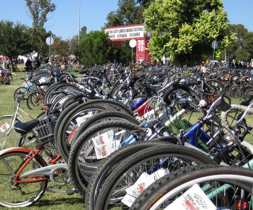
CHAPTER FIVE | MEASURING SUCCESS
Strategy 5.1a: Periodically monitor implementation progress and update Plan on a regular basis.
Strategy 5.1b: Monitor Austin’s progress. The Plan is a living document. It should be updated periodically to assess progress, identify new opportunities, and re-evaluate vision, goals, sub goals, strategies and actions.
A thorough plan evaluation investigates the achievement of strategies using quantifiable measures, reviews the effectiveness of interventions and policies, monitors public opinion, and then reassess the specific program plan. As a result, specific program actions can be modified to strengthen implementation of the plan. One component of evaluating progress is to establish benchmarks and report measures periodically. While it is the goal of the Austin 2023 Bicycle Plan to reach the established benchmarks on the timeline outlined, data should be collected, reported, and evaluated more frequently to assess ongoing progress and to test the quality and effectiveness of the benchmarks.
An annual report should document current benchmark levels towards plan goals as well as opportunities and priorities for implementation of the plan. This will help educate and coordinate all levels of City government and the public in the next direction forward. Annual evaluations should be published to the public and provided to senior management, the Imagine Austin priority program teams, relevant boards and commissions, and Council.
Facility types, projects and programs should be evaluated for their effectiveness in implementing the goals of the Plan. This includes the need to include regular collection of data from ridership counts, surveys, and mode splits to track the growth of cycling on both facilities and the network over time and qualitatively evaluate the user experience. These evaluations will help guide decisions on future use of those facilities or programs. The benchmarks in the Plan are ultimately oriented towards measuring the success of achieving the vision of this Plan.
Strategy 5.1 Indicators and Targets
- Evaluate benchmarks annually, and report them to appropriate City Boards, Commissions, and Council.
- Complete 10% of action items by 2024, 40% by 2028 and 80% by 2033.
- Update the Bicycle Plan at least every 10 years, with interim updates every five years.
- Achieve platinum level Bicycle Friendly Community designation by the League of American Bicyclists 2025 (or equivalent rating- applications are accepted every 3 years).
Strategy 5.1 Actions
5.1.1 - In 2024, the Bicycle Program will establish baseline measures for each benchmark in the Austin 2023 Bicycle Plan.
5.1.1a - If necessary, coordinate with appropriate City departments or public agencies to collect data for measures.
5.1.2 - Regularly collect and maintain local bicycling data, including monitored bicycle counts and bicycle-related traffic violations and crashes.
5.1.2a - Coordinate with appropriate agencies and/or City departments to include bicycles in all traffic counts, traffic models and transportation surveys in the area.
5.1.2a – Measure the effectiveness of promoting higher bicycle use including use rates among BIPOC, low-income populations, and varying geographies
5.1.2b - Coordinate with the Austin Police Department, Travis County Sheriff’s Department, University of Texas Police Department and Texas Department of Public Safety to establish and/or improve reporting methods for bicycle-related crashes and citations.
5.1.3 - Continue to use and expand use of public surveys, community ambassador programs, and other equity centered methods to evaluate public opinions of infrastructure, programs, and Plan implementation.
5.1.4 - Provide an annual report to document current benchmarked levels towards plan goals as well as opportunities and priorities for implementation of the plan.
5.1.5 - Evaluate new facility treatments, and pilot projects and programs.
5.1.6 - Update the Austin Bicycle Plan every 10 years. For this Plan, the interim update shall begin by December 31, 2019, and a major update by December 31, 2024.
Best Practices: Measuring Progress Based on Indicators and Targets Cities with successful bicycle programs have a tradition of establishing and accurately measuring benchmarks that show progress toward their goals. These cities also collect data for their benchmarks regularly to measure interim progress toward Plan goals. To ensure implementation of the Bicycle Plan, the City of Austin should strengthen its efforts in data collection to better monitor progress toward the goals and strategies of the 2023 Bicycle Plan Update.
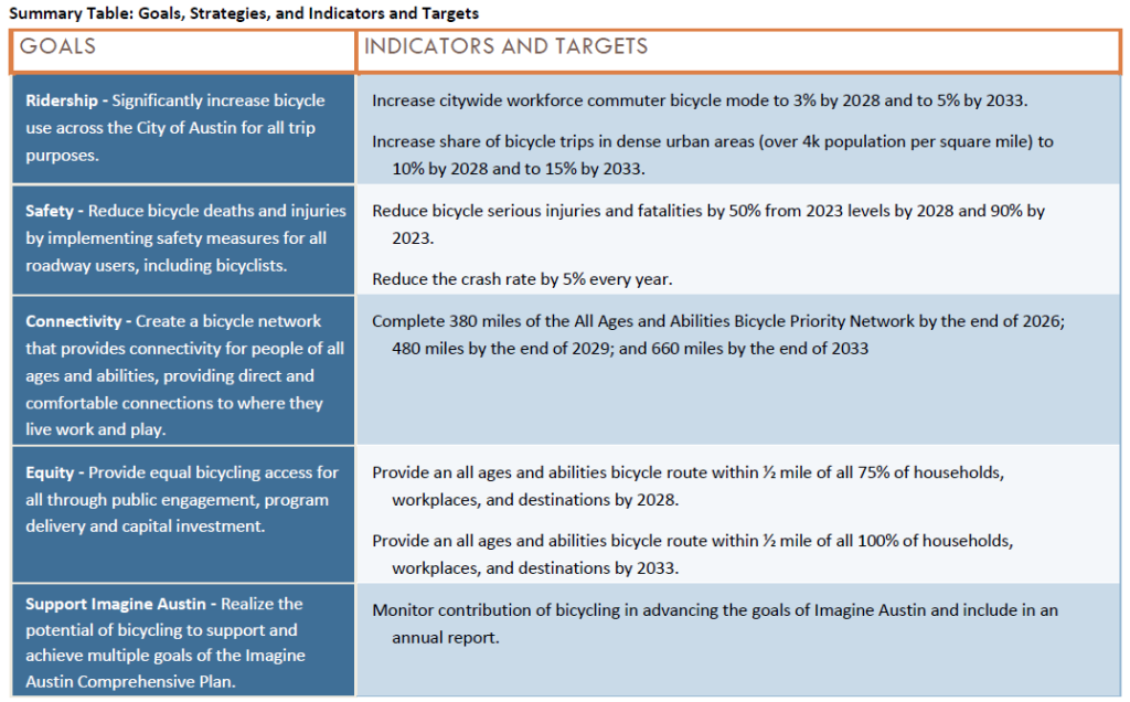
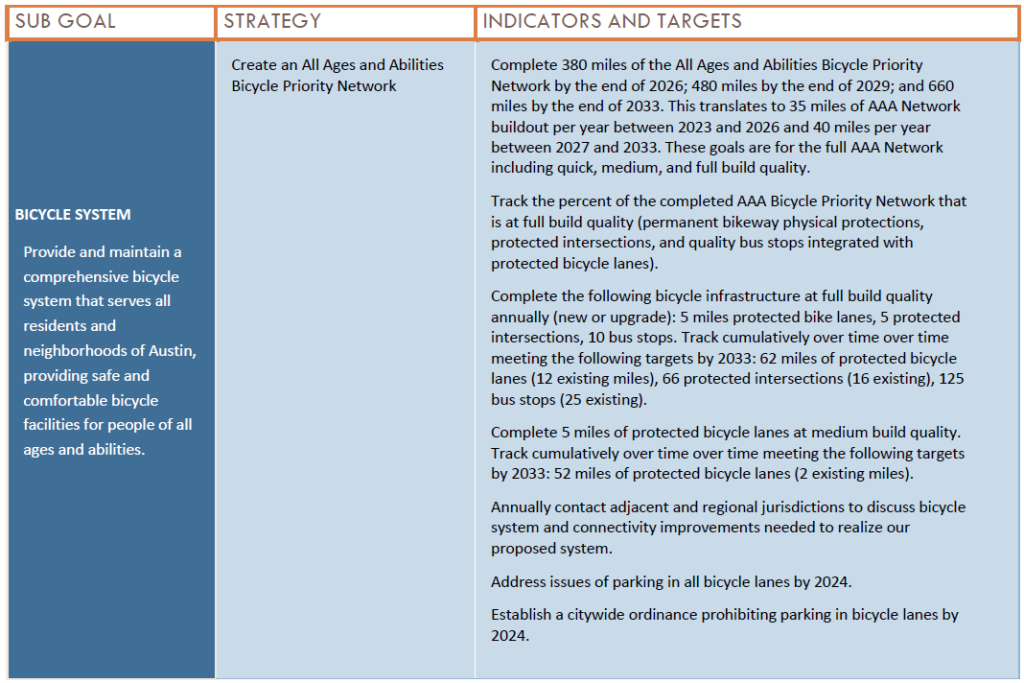

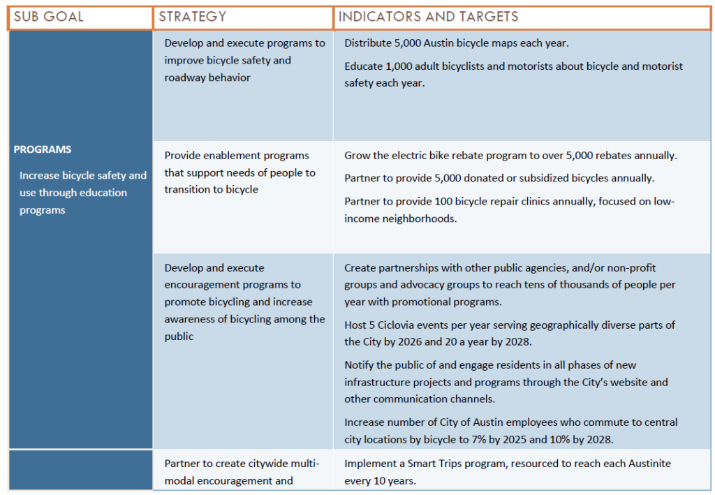
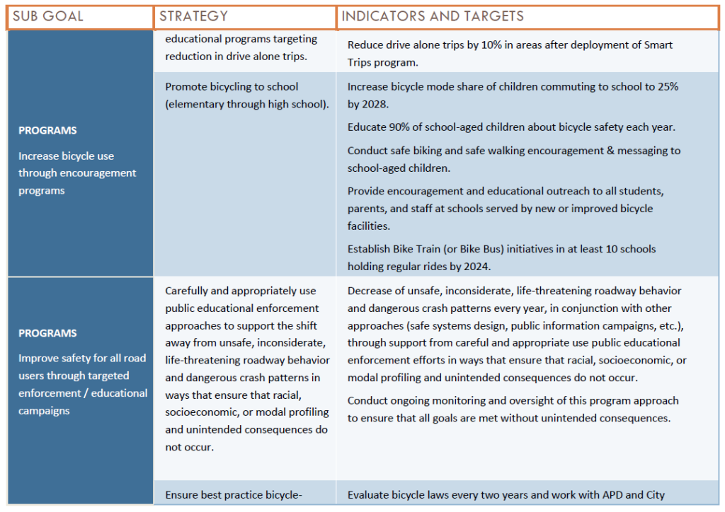
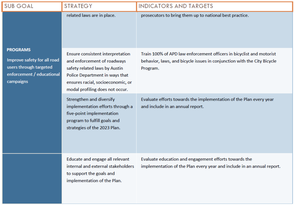
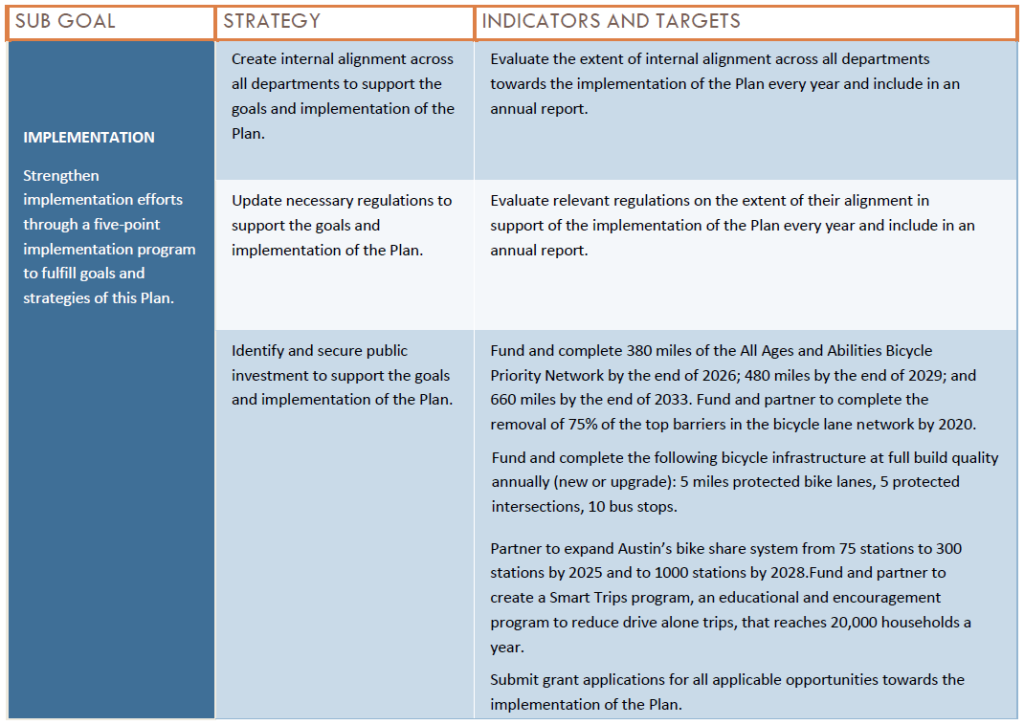
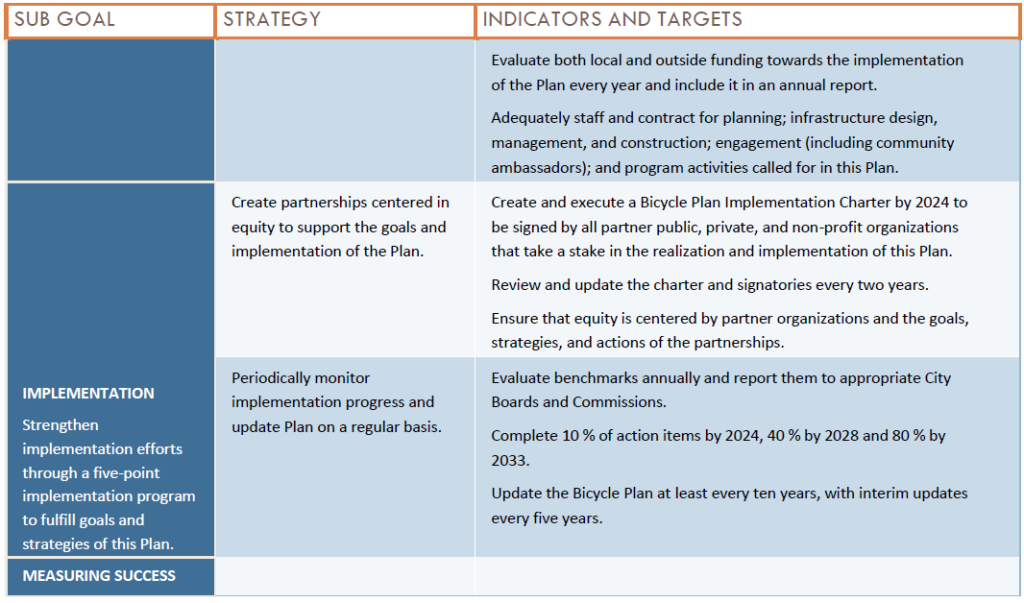
City of Austin Bicycle Plan
November 30, 2023
Appendices
Appendix A: ATX Walk Bike Roll Process Summary
Appendix B: Definitions
Appendix C: All Ages and Abilities Bicycle Priority Network Details and Cost Estimate
APPENDIX A: ATX WALK BIKE ROLL PROCESS SUMMARY ATXWBR OVERVIEW
ATX Walk Bike Roll was a coordinated effort by the City of Austin’s Public Works Department and the Transportation Department to update Austin’s Sidewalks, Crossings, and Shared Streets Plan; Urban Trails Plan; and Bicycle Plan. These plans guide how the City builds urban trails, sidewalks, shared streets, pedestrian crossings, and bikeways and identifies where they are needed most. For more information about ATX Walk Bike Roll, visit: AustinTexas.gov/ATXWBR.
GUIDING DOCUMENTS
The ATX Walk Bike Roll process—from community engagement to writing the three plans—centered equity and inclusion to create a more just transportation decision-making process and build lasting partnerships across Austin. The process and this commitment to inclusion were guided by three documents:
1. EQUITY SCAN
The Equity Scan included a review of 20 recent planning initiatives in Austin and engaged 17 stakeholders from 12 organizations dedicated to equity, anti displacement, public health, accessibility, and education. The goal was to understand, through the lens of community voices, how the City of Austin has incorporated equity into its plans, initiatives, processes, and outcomes, and where there are lessons to be learned. Conversations with local leaders highlighted priorities that ATX Walk Bike Roll should center, which were incorporated into the Public Outreach Plan and planning process. View Appendix A.1 for the Equity Scan.
2. EQUITY FRAMEWORK
The Equity Framework is a tool for accountability to guide decision-making during the ATX Walk Bike Roll process and afterwards during plan implementation. The development of the Equity Framework builds off past and ongoing work from the City’s Equity Office and was informed by stakeholder guidance from the Equity Scan and the Public Outreach Plan. The Equity Framework also identifies approaches to defining and considering geographic areas with infrastructure disinvestment, lower access to opportunity, and/or concentrations of underserved populations. ATX Walk Bike Roll used the Equity Analysis Zones developed in 2021 by the Austin Transportation Department and an Advisory Team of community members. Equity Analysis Zones are areas in Austin that have higher concentrations of historically marginalized populations and more barriers to achieving equitable outcomes. These Equity Analysis Zones were developed using weighting data from the United States Census that reflect an area’s social and economic vulnerability. The Equity Analysis Zones are classified into five categories from Least Vulnerable to Most Vulnerable. Throughout the planning process, input by residents within the Equity Analysis Zones was used to identify disparities in the existing and planned pedestrian networks, safe crossings, bike networks, and urban trails. Additionally, comparisons were made between Most Vulnerable/ Medium-High Vulnerable Equity Analysis Zones and the rest of the city to identify where resources should be prioritized. View Appendix A.2 for the Equity Framework.
3. PUBLIC OUTREACH PLAN
The Public Outreach Plan included steps for engaging the community as a whole and established a tailored strategy to engage focus populations (defined as Black, Hispanic/Latinx, and other People of Color, and those earning less than 80% of the median household income) about the challenges and opportunities facing historically underrepresented groups. View Appendix A.3 for the Public Outreach Plan.
MESSAGING, TOOLS, & TACTICS
We held two Virtual Open Houses:
The first Virtual Open House was held on Zoom on August 11, 2021, introducing the project and goals. The video presentation was posted online which was attended and later viewed by at least 729 people. The second Virtual Open House was hosted on an interactive webpage and open between September 7 and October 23, 2022, and focused on the project’s three scenarios for how the City of Austin can continue building urban trails and bikeways. An estimated 11,900 people visited this virtual open house. Both meetings were posted online for ongoing viewing.
We sought input through three surveys:
- June 14 – September 26, 2021: 4,411 people gave their input, on a survey and/or poll asking what residents value about the city’s pedestrian and bicycle pathways, and their main concerns and desires for the City’s pedestrian and bicycle networks.
- January 18 - March 7, 2022: A Mapping Survey was launched online and on paper, including both English and Spanish options. 9,778 people viewed the mapping site and 4,542 people provided survey responses. 2,807 placed markers on the map to indicate challenges, gaps, and opportunities related to walking and biking in Austin.
- September 7 - October 23, 2022: 2,108 people provided survey responses to either online or paper surveys which proposed three scenarios for how the City of Austin can continue building the pedestrian network, urban trails, and bikeways, asked about policy ideas and how to prioritize pedestrian crossings.
The Community Ambassadors engaged focus populations:
In August and September 2021, Community Ambassadors reached 316 people and shared 600 social media surveys. They completed 125 event reports, which documented community events or conversations where they spoke to people about walking and biking in Austin.
Ambassadors used a wide range of engagement activities, including: one-on-one conversations, small group discussions, tabling at local events or along busy corridors and urban trails, emails, social media, video chats, distributing flyers to local Housing Authority of City of Austin (HACA) developments and schools, and hosting other candid conversations with focus populations (defined as Black, Hispanic/Latinx, and other People of Color, and those earning less than 80% of the median household income).We employed print, broadcast, news media, emails, and social media to spread information and increase awareness about the project:
Marketing tools included emails, flyers, social media ads, social media posts, newsprint ads, media advisories, email campaigns, interviews with journalists, video production, website updates, and the utilization of partner organization’s communication channels.
We attended community events and gave presentations to community groups and Boards and Commissions:
In Phase 1, 130 tabling events and awareness activities, including two in-person events at the Mexican American Consulate and at the Boys and Girls Club of the Austin Area. We also made presentations about the project as part of six community group meetings. In Phase 3, we attended 12 tabling events, and presented at four boards and commissions and at three community groups.
We hosted Focus Groups:
Six focus group discussions were held during Phase 1 with the objectives to present the project; understand stakeholders’ interests, needs, and concerns; and facilitate deep-dive discussions about the project. 27 people participated in the Focus Group discussions, with group sizes ranging from 1 to 10 people.
HOW PUBLIC INPUT WAS USED TO DEVELOP THE PLANS
Strategies and Action Items
Community input highlighted the need to center equity, affordability, comfort, and connectivity in the plans. Specific concerns that came up repeatedly (especially amongst focus populations- defined as Black, Hispanic/Latinx, and other People of Color, and those earning less than 80% of the median household income) were expanded into plan goals, strategies, and action items.
Network Development
People were asked to identify where they’d like to see improvements to Austin’s walking and biking routes. The data people provided guided changes to the Proposed Urban Trails Network and Proposed All Ages and Abilities Bike Network. Data on challenging crossings was used to help prioritize pedestrian crossing projects.
Scenarios
Three urban trails and bikeways scenarios (which were oriented around different ways of prioritizing network expansion) and three sidewalks and shared streets scenarios (which explored building different proportions of sidewalks and shared streets) were presented to the public for feedback. Input on these scenarios shaped overall plan direction regarding targets and strategy development.
Project Prioritization
Through surveys and Community Ambassador input, participants told us what considerations should be used when projects are prioritized. This input was used to create or update data-driven prioritization methods for the urban trails and bikeways plans and to better emphasize equity as a prioritization factor.
Partnerships and Actions Beyond ATX Walk Bike Roll
Public input identified the need for action around equity, anti-displacement efforts, and affordability that go beyond the purview of the Austin Public Works and Transportation Departments. These issues and actions were collected for consideration in a future update of the Austin Strategic Mobility Plan and by other City departments.
The following goals were articulated in the Public Engagement Plan.
- Implement a process that carries out the recommendations and guidance outlined in the project’s Equity Framework and results in participation that exceeds the racial/ethnic and income demographic makeup of the city.
- Prioritize engagement with stakeholders from historically underrepresented and underserved populations by collaborating with community organizations with access and credibility to these populations. Value this expertise through incentives and/or compensation for time.
- Create awareness of ATX Walk Bike Roll and associated Plan Updates, the public input needed, and the overall update process.
- Present information in a manner that respects native languages and is culturally appropriate.
- Provide a variety of methods for public participation that are accessible in terms of language, technology literacy, location, and time so that people from focus population groups may easily participate in the process.
-
Gain substantive insights from the public input process that establishes a vision for each of the Plan Updates and guides the technical elements of the updates.
As described in the Phase Summaries below, goals #2 through #6 were met. Regarding Goal #1, the Community Ambassador program and other targeted efforts resulted in deep and broad engagement with people from historically underrepresented groups and annual household income under $50,000. However, as shown in Table 1 and 2, participation from People of Color and people with lower incomes did not exceed the racial/ethnic or income makeup of Austin. Although this goal was not met, demographic questions asked as part of outreach activities allowed the project team to review responses from the focus population separately (defined as Black, Hispanic/ Latinx, and other People of Color, and those earning less than 80% of the median household income), to review differences and elevate input received from those respondents.
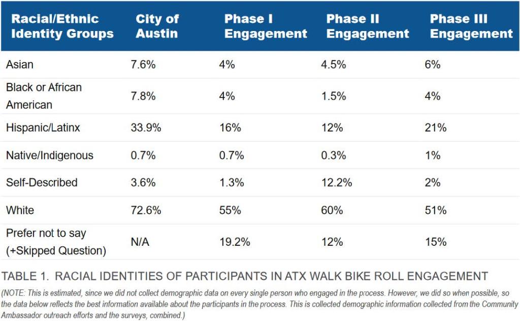
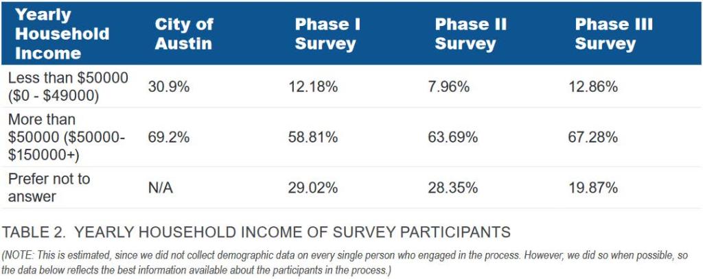
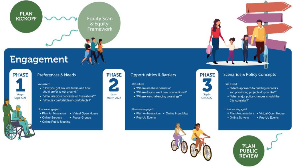
PHASE SUMMARIES
ATX Walk Bike Roll engagement was organized around three primary phases, illustrated in the graphic to the left and further described on the following pages.
PHASE 1: PREFERENCES AND NEEDS
From August through September of 2021, Phase 1 of engagement sought to connect with residents – particularly those that have been historically underrepresented in past City planning efforts (Black, Hispanic/Latinx, and other People of Color, and those earning less than 80% of the median household income) – to raise awareness about ATX Walk Bike Roll and collect insight on how urban trails, sidewalks, pedestrian crossings, and on- street bicycle infrastructure impacts quality of life. The objectives of Phase 1 were to:
- Raise awareness of ATX Walk Bike Roll
- Document the experiences of residents when using active transportation infrastructure
- Share ATX Walk Bike Roll’s purpose, goals, challenges, and the planning process
- Create trust and build relationships with focus populations, guided by the Equity Framework
- Understand how residents currently get around Austin, their concerns about active transportation, and what improvements they’d like to see.
- Use public input to guide the development of scenarios for bikeways, trails, and sidewalks in Phase 3
Phase 1 of ATX Walk Bike Roll sought to create new industry best practices for prioritizing the lived experiences of underrepresented communities in planning efforts. Phase 1 engagement activities included surveys, small group events, and a pre- recorded virtual public meeting. Some Phase 1 activities also had to be adapted to the changing circumstances of the COVID- 19 pandemic.
To center diverse populations in the engagement process, Phase 1 Public Outreach activities had a wide reach. Focused strategies — including Community Ambassador outreach, focus groups, and collaboration with community organizations that center equity in their mission and programs — successfully boosted engagement among Black, Hispanic/Latinx, and other People of Color, and those earning less than 80% of the median household income. Broader methods like the online survey and the virtual public meeting disproportionately represented high-income and White populations. This emphasized the importance of focused strategies, particularly the Community Ambassador Program, as vital to reaching low-income communities and communities of color.
Community Ambassadors were much more successful in reaching focus populations (defined as Black, Hispanic/Latinx, and other People of Color, and those earning less than 80% of the median household income) compared to broader engagement methods like surveys and public meetings. Because of the successes of Community Ambassadors, the Public Outreach Plan was restructured to extend their work into Phases 2 and 3 of engagement efforts and strategies were modified to prioritize efforts designed to achieve better demographic representation to calls for engagement.
Across engagement efforts in Phase 1, participants from focus population communities expressed confusion and/or planning fatigue because of the simultaneous outreach efforts addressing upcoming transit investments in Austin. Phases 2 and 3 sought to improve on this by enhancing coordination and synchronization of messaging between the efforts, clarifying distinctions between various transportation-related projects, and sharing engagement results between projects.
More detail on outreach and a summary of public input is in Appendix A.4 Phase 1 Summary.
PHASE 2: OPPORTUNITIES AND BARRIERS
Phase 2 engagement took place from January through March of 2022. A map based outreach approach was utilized to record feedback from community members. This informed prioritization models in alignment with our Equity Framework to ensure that implementation plans match demonstrated need. Feedback, preferences, and concerns from focus populations in Phase 1 were examined and elevated as the project moved into this Phase of engagement. Increased investment was given to the Community Ambassador program which transitioned from being managed by the consultant team to being managed by City of Austin staff in January. Objectives for Phase 2 engagement were to:
- Explore themes and priorities heard from Phase 1
- Identify important gaps in the urban trail and bikeway networks, locations of barriers, opportunities for new urban trail or bikeway connections, and places where crossing the street is challenging Envision opportunities to improve connections to transit
- Gather preferences on active transportation programs like Smart Trips and Shared Streets
- Understand what is and is not working as it relates to facility maintenance
- Digest specific displacement concerns in order to craft a responsive plan for action in collaboration with ongoing anti-displacement efforts in Austin
Phase 2 engagement activities included Social Pinpoint/Online Mapping Tool available in English and Spanish; paper maps and paper surveys utilized by Ambassadors; tablet-based access to the online mapping tool delivered by Ambassadors; pop up events, shared street pop- up events hosted by Austin staff and supported by Ambassadors; and continued Ambassador reports.
Community Ambassadors were equipped with tablets to encourage community members without easy access to a computer to take the digital survey. However, technological barriers and internet access issues prevented tablets from being a successful outreach tool. Nevertheless, through conversations and the use of paper maps, Community Ambassadors were able to continue receiving feedback.
Community Ambassadors also began functioning as project advisors providing feedback on design guidance in March. That feedback was invaluable. The engagement plan was modified to allow Community Ambassadors to continue to engage with community members and to formally utilize Community Ambassadors as advisors to the project and sponsor team. The online survey tool was also promoted through Austin’s traditional communication channels. 9,778 people viewed the site and 3,319 people provided input or upvoted comments. Participants left a total of 2,807 markers on the map and completed 4,542 survey responses. The survey metrics included responses to the demographics survey as well as to questions about the markers dropped on the map. This survey effectively captured network gaps and challenges for people with technological access and skills but required internet access, technological knowledge, and larger screens to easily drag, drop, and draw desired connections on computers, phones, or tablets. To mitigate skewed results the project team again examined and prioritized responses from people in focus populations weighting those responses more heavily. More detail on outreach and a summary of public input is in Appendix A.5 Phase 2 Summary.
PHASE 3: SCENARIOS AND POLICY CONCEPTS
September and October of 2022 focused on presenting major plan elements for public feedback. Community members were asked to rate their level of support for three Urban Trails and Bikeways and Sidewalk and Shared Street scenarios. Phase 3 also asked if participants supported transportation policies that were meant to reduce transportation costs in an equitable way and address hidden subsidies that currently favor automobiles above other transportation options.
The objectives of Phase 3 were to gather feedback to shape:
- Network plans for urban trails and bikeways
- How large a role shared streets should play in Austin’s future pedestrian network
- Prioritization methods for urban trails, bikeways, and pedestrian crossings
- Transportation policies to improve equitable outcomes from infrastructure investments
Phase 3 presented a key moment to make major decisions about where to direct new investment in walking, biking, and rolling infrastructure. The options presented in the Phase 3 survey were created using input from Phases 1 and 2. The Phase 3 survey, offered in English and Spanish, was available online and as a paper version, and used non-technical language and images to convey complex concepts. A shortened paper version of the survey focused on key issues and was used at tabling events in focus population communities.
Community profiles were written using past input to convey the challenges and opportunities that low-income residents and/or communities of color shared to a broad audience. In conveying the transportation realities faced by these focus populations, all survey participants could better understand how planning decisions might impact the lives of various residents. These community profiles were also used throughout Phase 3 tabling efforts and within our information packets as a way to humanize data. Profiles were born out of conversations with Community Ambassadors who questioned the efficacy of highly curated presentations complete with new terms and concepts. These were used to guide the creation of options for how to prioritize investments.
The next engagement opportunity to provide feedback involved gathering input on a series of sidewalk, bikeways, and urban trails implementation scenarios. Participants gave input on their level of support for each scenario and provided input on elements they did and did not like about each proposal. Policy considerations were also included with the desire to gain input on broad and important issues not solely transportation related, including affordability and displacement, climate resiliency and other key issues raised by focus populations over the first two engagement rounds.
The project team recognized that all Phases of engagement were significantly oversampling predominately white and wealthy residents. This was addressed in three ways.
- Responses from low-income respondents and from People of Color were examined more closely.
- Concerns and opportunities raised in Community Ambassador reports became central in decision making.
- Community Ambassadors were enlisted as advisors in decision making.
These sources of information influenced the design of policy recommendations to address the many overlapping concerns that the focus populations expressed across all Phases of engagement.
More detail on what we did and a summary of key themes from the input received is in Appendix A.6 Phase 3 Summary.
LOOKING AHEAD TO NEXT STEPS ATX
Walk Bike Roll sought to move beyond community engagement and into community partnerships. Understanding and acknowledging past harmful policies—in Austin generally and by the transportation profession specifically—enabled project staff to work with historically marginalized community members (defined as Black, Hispanic/ Latinx, and other People of Color) to test new approaches rooted in cultural responsiveness. historically marginalized community members engaged throughout this process also expressed an expectation that these sentiments be backed by action to ensure that key concerns are addressed and prioritized moving forward.
Across Phases we acknowledged when engagement methods failed to uphold the commitment to equitable engagement and listened to focus population voices to influence adaptation. When majority populations (people who are white, wealthier, and historically had and currently have more power in decision making) were “... to move beyond community engagement and into community partnerships.” oversampled in engagement, increased weight was given to the voices of focus populations. This was done in the examination of survey results and in spending resources to listen to the long form narratives reflecting the stories, realities, and lived experiences of focus populations. We also reflected on common transportation experiences faced by focus populations as an educational tool, to better inform individual participants’ feedback. The voices of focus populations clearly described the interconnectedness of issues like housing affordability, sustainability, personal safety, and land use planning. Though the focus of the work of ATX Walk Bike Roll is active transportation, we recognize how interconnected the success of these plans are with those other topics. The community is calling for departments to break through rigid agency silos and collaborate with other City departments that address housing, utilities, and public health, to further conversations about how policy and programming can create a more just city.
Austin is experiencing an affordability crisis. As neighborhoods become more expensive, families and individuals are pushed to areas with less connectivity. An improved active transportation network across the city would help mitigate these factors, and it no longer would be a luxury to live in an area with great connectivity. Recognizing how these concerns have historically manifested in Austin’s built landscape, the prioritization approach shifted to elevate projects around existing corridors with long term, stable affordable housing to ensure long standing residents can stay in place.
As the three plans developed during ATX Walk Bike Roll are adopted and move to implementation, the following key considerations for future efforts are essential to continue upholding commitments to equity in action:
VALUING LIVED EXPERIENCE
Valuing and prioritizing expertise that comes with lived experience is an important component to successful planning and implementation. Continuing to evaluate future decisions through the lens of focus populations will be necessary for the long-term success of ATX Walk Bike Roll. The Community Ambassadors were an asset in this area. They were more skilled at and capable of reaching people from focus populations than any other outreach efforts because of pre- established relationships and deeper levels of trust.
They were able to bring their own lived expertise:
- influencing how the City’s planning team thought through implementation priorities,
- helping the planning team better tailor language and communicate more clearly,
- leading informal cultural and active transportation education for City staff,
- providing honest and candid feedback, and
-
remaining a steady voice for planning efforts to better align with equity goals. Austin would be well served by employing Community Ambassadors to continue in that role through implementation and beyond to other projects.
DESIGNING TOOLS FOR ALL
Language and access are two key themes that consistently surfaced throughout outreach. Someone’s access to the internet, ability to speak a certain language, or understanding of highly technical language should not limit their ability to share their thoughts on public issues. All materials, surveys, and outreach content should account for these considerations to ensure that those who have been historically left out of planning processes are included and at the center of outreach efforts.
COMPENSATION AND COORDINATION
Learning from Phase 1, outreach efforts with the potential to drastically increase diverse representation may have faltered because communities who have faced historic disinvestment are continually asked to share input without compensation. ATX Walk Bike Roll is just one of many ongoing efforts occurring in Austin. This may mean many community leaders from focus populations have been repeatedly engaged and answered similar questions creating engagement fatigue. To recognize this labor, transparency about when and how their responses will be used is critical and should also be supported with compensation for their participation. The significant impact of our ATX Walk Bike Roll Community Ambassadors highlights the need for similar programs to become citywide engagement standards, with adequate compensation for time and labor.
Further coordination between projects and departments is critical to make sure feedback gathered is shared across time, projects, and departments so people are not over surveyed.
INTEGRATING ACTIVE TRANSPORTATION AND ANTI- DISPLACEMENT EFFORTS
While centered on walk, bike, and roll infrastructure, many of the responses across the three project Phases tied these issues to concerns for housing affordability and anti-displacement. As such, it is critical that active transportation improvements are not viewed or implemented in silos, but rather build on the integrated work that has already begun directing improvements to sidewalk networks, urban trails and bikeways with community preservation efforts. As Austin becomes increasingly unaffordable, particularly for Black people, Hispanic/Latinx people, other People of Color, and low-income residents of all races and ethnicities, it is critical that new investment is accompanied by strategies to allow focus populations to age in place, and access is improved so people can get to the places they need to go.
EMBRACING MULTIPLE APPROACHES
Relying on a robust set of tools for engagement allows residents multiple ways to get involved. Engagement approaches like public meetings and tabling should be located in places familiar to focus populations and promoted through channels utilized by focus population communities. Less formal approaches led by trusted community members, like Community Ambassadors, allows people from focus population communities to engage as part of a typical day in candid conversations with friends, loved ones, while waiting on a bus or using transit, or folding laundry in the laundromat. These methods allow people to provide input who don’t necessarily feel driven to respond to conventional outreach channels.
APPENDIX B: DEFINITIONS
A C R O N Y M S
AAA: All Ages and Abilities
AAA Bicycle Priority Network: All Ages and
Abilities Bicycle Priority Network
ASMP: Austin Strategic Mobility Plan
D E F I N I T I O N S
2014 Bicycle Plan, the 2014 Plan: Names used to refer to the previous 2009 Bicycle Plan.
2023 Bicycle Plan, the 2023 Plan, The Plan: Names used throughout the document to refer to this plan.
All Ages and Abilities Bicycle Priority Network: A bicycle network that would appeal to people of all ages and abilities, such as the very young and very old. The network is composed of protected bicycle lanes, neighborhood bikeways, and urban trails. Reference to the All Ages and Abilities Bicycle Priority Network refers to a network of these three types of facilities that could be realistically and cost effectively implemented within the next five years and within the context of existing traffic volumes, on-street parking demands and construction feasibility.
Bicycle: A device that a person may ride and that is propelled by human power and has two tandem wheels, at least one of which is more than 14 inches in diameter. (Texas Transportation Code, Chapter 541. Definitions, Subchapter C)
Bicycle boulevard: See “Neighborhood bikeway”.
Bicycle friendly (bikeable): Descriptive term that describes policies, places and practices which provide safe, comfortable, and convenient opportunities for people of all ages and abilities to ride bicycles.
Bicycle lane (conventional bicycle lane, bike lane): An area within the roadway specifically designated for the use of bicycles which is delineated from motor vehicle traffic lanes by a painted line.
Bicycle network: A network of bicycle routes, including protected bicycle lanes, urban trails (multi-use paths), bikeways, neighborhood bikeways (bicycle boulevards), buffered bicycle lanes, bicycle lanes, wide shoulders, designated wide curb lanes, and designated shared lanes.
Bicycle plan implementation charter: A document issued by the Bicycle Program/Active Transportation Program that formally authorizes the existence of the Bicycle Plan and provides the Bicycle Program/Active Transportation Program Manager with the authority to apply organizational resources to project activities. A charter will be produced for
each city department outlining the action items in this Bicycle Plan which rely on resources from that department. Bicycle Playground: A professionally designed facility focusing either on miniature streetscape mockups for road riding instruction (also known as "traffic gardens") or an off-road skills-developing track with obstacle features, like rollers, platforms, banked turns, tunnels, etc. Bicycle route: A segment of the bicycle network with appropriate directional and informational markers as designated by the appropriate jurisdiction. These markers specify bicycle route numbers.
Bicycle system: The combination of the bicycle network, integrated transit, and end-of-trip or support facilities, such as bicycle parking, showers and changing facilities.
Bicyclist (cyclist): A person operating a bicycle, often phrased as a person on a bicycle or a person riding a bicycle.
Bikeway (bicycle path, separated bikeway): An area not within the roadway specifically designated for the use of bicycles.
Central City: Area defined by the Bicycle Program/Active Transportation Program, bound roughly by Oltorf Street to the south, Pleasant Valley Road to the east, FM 2222 to the north, and MoPac to the west. Includes the 2000 Travis County Census
Tracts 1.01, 2.01, 2.03, 2.04, 3.01, 3.02, 4.01, 4.02, 5.00, 6.01, 6.03, 6.04, 7.00, 8.01, 8.02, 8.03, 8.04, 9.01, 9.02, 10.00, 11.00, 12.00,13.03, 13.04, 13.05, 14.01, 14.02, 14.03, 16.02, 16.03, 16.04, 16.05, 16.06, 19.01, 19.11, 23.04, 23.15, 23.16.
Climbing lane: An area within the roadway specifically designated for the use of bicycles (a bicycle lane) only on the uphill direction of a roadway.
Complete bicycle facility recommendations: Recommendations for all streets in the plan, not filtered by near term feasibility. These recommendations may take many decades or more to realize. Recommendations are based on speed, volume criteria and other contextual factors.
Complete street: A street that is designed and operated to enable safe access for users of all ages and abilities and all modes, including, but not limited to people travelling by foot, bicycle, transit, and motor vehicle. All users should be able to safely move along and across a complete street.
Electric bicycle: A bicycle that (a) is designed to be propelled by an electric motor, exclusively or in combination with the application of human power; (b) cannot attain a speed of more than 20 miles per hour without the application of human power; and (c) does not exceed a weight of 100 pounds. (Texas Transportation Code, Chapter 541. Definitions, Subchapter C) End-of-trip facilities: Supportive facilities for bicycling, such as bicycle parking or shower and changing facilities. Lane reconfiguration (lane conversion, road diet, lane diet or rightsizing project): A type of roadway conversion project where the number or type of travel lanes are reconfigured. Lane reconfigurations are most commonly done to improve safety and multimodal access.
Motorist: A person operating a motor vehicle.
Motor vehicle: While e-bicycle and scooters have motors, in this plan this term refers to automobiles.
Multi-use path: See “shared use path”. Natural-surface trail (single track, nature trail, unpaved trail): A natural surface (i.e., existing dirt/clay) path through a forest, field, park, etc., typically singletrack width, appropriate for both hiking and mountain bike use. Neighborhood bikeway (neighborhood greenway, bicycle boulevard): A street on which bicycling and walking are prioritized through techniques including, but not limited to, traffic calming, motor vehicle traffic diversion, reconfiguration of stop signs to favor the corridor, placemaking and crossing improvements at busy cross streets.
Pedestrian: A person on foot (Texas Transportation Code, Chapter 541. Definitions, Subchapter A). Protected bicycle lane (protected bike lane, cycle track): A protected bicycle lane is an exclusive bike facility that combines the user experience of a separated path with the on-street infrastructure of a conventional bike lane. A protected bicycle lane is physically separated from motorized traffic and distinct from the sidewalk. Protected bicycle lanes have different forms, but all share common elements— they provide space that is intended to be exclusively or primarily used for bicycles and are separated from motor vehicle travel lanes, parking lanes, and sidewalks. In situations where on-street parking is allowed protected bicycle lanes are located to the curbside of the parking (in contrast to conventional bicycle lanes).
Road diet: See “lane reconfiguration”. Protected intersection: (Dutch, setback, or offset intersections): Intersection design that keeps bicycles physically separate from motor vehicles up until the intersection, providing a high degree of comfort and safety for people of all ages and abilities.
Shared lane: Any travel lane that is 14 feet wide or less that may be legally used by bicycles regardless of whether such facility is specifically designated as a bicycle route. The lane width is measured from the lane stripe to the edge of the gutter pan.
Shared lane marking (sharrow): A marking on the roadway that indicates where within a shared lane or wide curb lane a bicyclist should be positioned.
Shared use path (multi-use path): Shared use paths are either hard-surface or loose surface trails designed for the use of pedestrians, bicyclists and people using other non-motorized forms of transportation for both transportation and recreational use.
Single track trail: An unpaved trail, usually only wide enough for one user at a time.
Traffic calming: The combination of mainly physical measures that reduce motor vehicle speeds and potentially volumes to improve conditions for all street users.
Traffic garden: A youth-oriented instructional facility featuring a miniature cityscape for teaching road riding skills in a controlled environment.
Wide curb lane: A right-most through traffic lane that is greater than 14 feet wide, measured from the lane stripe to the edge of the gutter pan. A person on a bicycle and motor vehicle may potentially share the lane side by side (if in accordance with the City of Austin’s Vulnerable Road Users Law, § 12-1-35).
Wide shoulder: Shoulders that are the width of a motor vehicle or greater, often on rural highways, that improve emergency vehicle access, improve roadway safety, and provide for non motorized use such as bicycle travel.
Urban Trail: Urban Trails are hard-surface trails designed for use by people walking, bicycling, and rolling for both transportation and recreational use. Urban Trail priorities are set by the Urban Trails Program and guided by the Urban Trails Plan.
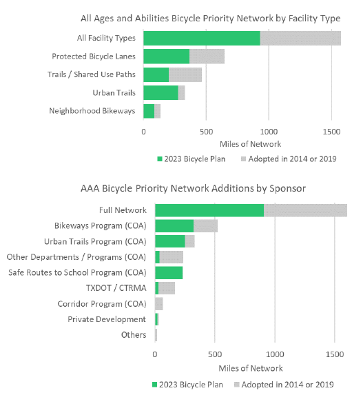
APPENDIX C: AAA BICYCLE PRIORITY NETWORK DETAILS AND COST ESTIMATE
SUMMARY OF AAA BICYCLE PRIORITY NETWORK ADDITIONS
The ATXWBR planning effort added 600 on-street miles to the AAA Bicycle Network
- ½ of these miles were needs identified by the Safe Route to School Plans
- ½ focused on equity and connections to neighborhood and city-wide destinations and connections to nature
The AAA Network is being built by many partners. The chart below shows the new network additions by each program / entity during this plan cycle.
COST ESTIMATE FOR AAA BICYCLE PRIORTY NETWORK
The unfunded cost of the All Ages and Abilities Bicycle Network is $1.15 billion. This planning level cost estimate assumes high quality levels of buildout as seen on recent projects like Teri Lane and Shoal Creek Boulevard, which use a mix of quick build techniques on segments and full-build protected intersections in concrete.
It is notable that protected bicycle lanes and neighborhood bikeways make up 74% of the network mileage yet only 32% of the cost of $370 million. Trails and Shared Use Paths which include bridges and underpasses make up 23% of the network mileage but account for 68% of the cost of $783 million due to the higher cost per mile. The project prioritization for bikeway funds includes a cost factor so projects that have a lower cost per mile will be elevated in priority as one of many factors (Equity, Destinations and Travel Demand, Connectivity and Safety). More detail can be found in
Chapter 2 Bikeway System, section Project Prioritization.
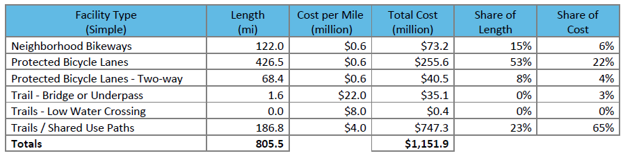
Notes:
• Includes projects that would use future flexible City of Austin Bikeway bond resources.
• Excludes Urban Trails.
• Excludes projects sponsored by other entities or programs (e.g., Corridor Program, TxDOT, CTRMA, Cap Metro, Counties)
• Excludes facilities outside of the City’s jurisdiction.
• Excludes projects that are already funded (Phase is complete, in construction, or have estimated end dates / are funded).
• Facility types are simplified while maintain differentiation in costs.
• Facility types have been assessed at a planning level and are subject to change as part of project development and further feasibility study.