
We design, build and evaluate engineered systems to reduce pollution in our creeks, lakes and aquifers. We seek to use stormwater as a resource rather than a waste product.
This page summarizes the process of our work and highlights several projects.
Featured Project – Buttermilk Creek Water Quality Improvements
Thank you to everyone who joined us at the public meeting about Buttermilk Creek. If you missed the meeting, a recording of the presentation is below:
- Presentation from January 27, 2026
- Recording of Presentation from January 27, 2026
- Skip to more information about the Buttermilk Creek project.
Tools for Improving Water Quality
There are a variety of ways that we can treat stormwater and remove pollutants. Our projects might include the following:
- Biofiltration ponds
- Rain gardens
- Rainwater harvesting
- Irrigation & Infiltration fields
- Sedimentation filtration ponds
- Vegetated filter strips
- Wet ponds
Easements
We sometimes need to purchase easements from private property owners to construct our projects. Easements are a legal right that allows us to use a designated portion of another person’s property for a specific purpose. There are many different types of easements, and the specified purpose can vary. Easements can be temporary or permanent. For our drainage projects, we generally purchase both temporary easements for construction and permanent drainage easements.
Process
Our capital improvement projects take many years from start to finish. The process typically includes the following phases:
- Feasibility Study – when information is collected to identify potential solutions.
- Preliminary Engineering – when a solution is identified and costs are estimated.
- Design and Permitting – when the details are worked out, construction plans drawn up and permits are acquired. Easements, if needed, are usually acquired during this phase as well.
- Bidding – when a contractor is hired.
- Construction – when the project is built.
Construction is dependent upon the availability of funding. In some cases, we are not able to identify a feasible or cost-effective solution during the first two phases.
Report a Drainage Concern or Pollution Spill
Resources for Engineers
The City of Austin’s Stormwater Load Analysis Tool (SLAT) is meant to accompany the Environmental Criteria Manual, Section 1.6.9, for sites within the Barton Springs Zone. It calculates a proposed development’s pollutant load.
- Environmental Criteria Manual
- Drainage Criteria Manual
- Green Stormwater Infrastructure Maintenance Manual
- Wet Pond water balances spreadsheet
- Appendix T: Request for Fee In Lieu of Water Quality Controls in the Urban Watersheds
- Appendix T Instructions
- SLAT 2.1 (Excel)
- SLAT - 2.1 User Manual
Project Summaries
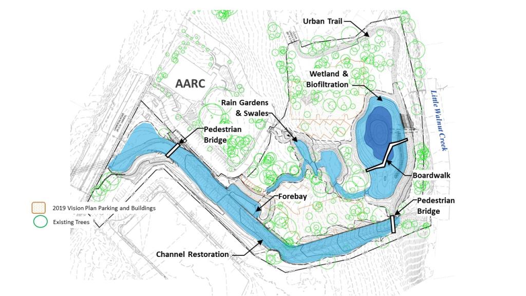
- Asian American Resource Center Stormwater Improvements
-
Located primarily at the Asian American Resource Center, this project will improve water quality in the Rutherford Tributary of Little Walnut Creek. Currently, the water quality is affected by high nutrient levels, poor stream habitat and erosion. The project includes:
- Expanding the existing biofiltration pond and adding a wetland area
- Adding a new stream and rain garden
- Changing the concrete channel to make it more natural
- Replacing concrete-lined side slopes with limestone blocks
- Installing vegetated concrete block matting
- Installing two pedestrian bridges over concrete channels, one near the AARC/Rutherford Campus parking lot and one near the board walk
- Adding trails, landscaping and a play area
In addition to improving water quality, the project will enhance the appearance of the resource center, add amenities, reduce flood risk, reduce erosion and increase wildlife habitat. View map of proposed improvements.
Watershed
Rutherford Tributary to Little Walnut Creek
Location
The project is located on the grounds of the Asian American Resource Center and at the City of Austin's Rutherford Campus.
Status
This project is currently in design with construction estimated to begin in 2026.
Documents
- Presentation from October 22, 2024 public meeting
- Recording of October 22. 2024 public meeting
- English Factsheet, also available in:
- العربية (Arabic)
- မြန်မာစကား (Burmese)
- 廣東話 (Simplified Chinese)
- 한국어 (Korean)
- Tiếng Việt (Vietnamese)
Questions?
Please reach out to one of the following people:
- Claudia Corsetti, P.E., Project Manager, at 512-974-7205 or email Claudia
- Lee Sherman, Project Sponsor, at 512-974-6555 or email Lee
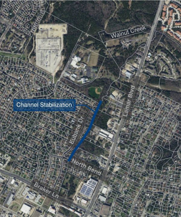
- Bartholomew Park/Morris Williams Water Quality Improvements
-
The project will improve the water quality and the health of Tannehill Branch Creek. To do this, we are proposing to change existing drainage infrastructure in Bartholomew Park and Morris Williams Golf Course. The project includes:
- Changing the existing flood detention pond at Bartholomew Park to include a permanent wet pond
- Creating a new Safe Routes to School trail through Bartholomew Park.
- Improving the existing wet pond and constructing a second wet pond at Morris Williams Golf Course
- Creating a wetland at Morris Williams Golf Course
- Enhancing the natural habitat along Tannehill Branch Creek
- Upgrading wastewater lines along Tannehill Branch Creek near Morris Williams Golf Course
The project will help address water quality in Tannehill Branch Creek while supporting recreation in the parks. The creek has high nutrient levels and lacks plant and wildlife habitat near its banks. Both contribute to problems like erosion and unwanted algae growth.
Watershed
Tannehill Branch Creek
Location
The project is located in Bartholomew District Park and at the Morris Williams Golf Course. View location map.
Status
This project is currently in the design phase. Construction is dependent upon the availability of funding.
Opinion of Probable Construction Cost
$19.5 million
Documents
- Presentation from March 8, 2025, Community Meeting
- Factsheet: Tannehill Branch Water Quality Improvements
Questions?
Please reach out to one of the following people:
- Lee Sherman, P.E., Project Sponsor, 512-974-6555 or email Lee
- Clayton West, P.E., Project Sponsor, 512-578-5150 or email Clayton
- Minda Sarmiento, P.E., ENV SP, Project Manager, 512-974-5645 or email Minda
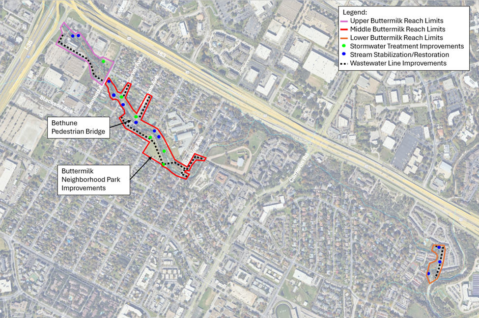
- Buttermilk Creek Water Quality Improvements
-
This project addresses poor water quality and erosion along Buttermilk Creek in northeast Austin. We are working with Austin Water to restore the creek and enhance wildlife habitat. We’ll be stabilizing the creek banks, repairing and upgrading wastewater infrastructure, and removing pollutants from stormwater.
This is a large project with many components, including:
- Stormwater controls: Includes new biofiltration ponds, rain gardens, a bioswale and an inline detention pond
- Streambank stabilization: Includes limestone walls, stones, vegetation and grading at 11 erosion sites
- Wastewater protection: Includes relocating or protecting exposed wastewater lines and manholes
- Park improvements: Includes restoring wildlife habitat, improving the pedestrian bridge and adding new amenities at Buttermilk Neighborhood Park
- Removing failed infrastructure: Includes removing two damaged concrete ponds.
Public Meeting
Join us for a public meeting to learn more about this project:
- When: Tues., Jan. 27, 2025, from 6 to 7 p.m.
- Where: Virginia L. Brown Recreation Center, 7500 Blessing Ave.
- Interpretation: To request interpretation, please email Zach Jarjoura or call 512-460-9579 at least 7 days before the meeting.
Watershed
Buttermilk Creek, which flows into Little Walnut Creek
Location
This project is near the St. Johns, Coronado Hills and Old Towne neighborhoods. Part of the project is within Buttermilk Neighborhood Park.
Status
This project is currently in the design phase. Construction is anticipated to begin in fall 2026.
Please visit PublicInput.com/Buttermilk to join our email list for updates.
Opinion of Probable Construction Cost
This project received $22.16 million in financial assistance from the Texas Water Development Board through the Environmental Protection Agency’s Clean Water State Revolving Fund Program. In addition, $959,752 was issued through Congressionally Mandated Project funding in the FY 2024 Consolidated Appropriations Act under the Environmental Protection Agency’s Community Grant Program. These awards should cover the entire cost of the project.
Documents
- Presentation from January 27, 2026 public meeting
- Recording of Presentation from January 27, 2026
- Middle Buttermilk Creek: Recording of August 2023 presentation
- Middle Buttermilk Creek: PDF of August 2023 presentation
- Lower Buttermilk Creek: Recording of July 2024 public meeting
- Lower Buttermilk Creek: PDF of July 2024 presentation
- Lower Buttermilk Creek project map
Questions?
Please reach out to one of the following people:
- Minda Sarmiento, P.E., ENV SP, Project Manager, 512-974-5645 or email Minda
- Clayton West, P.E., Project Sponsor, 512-578-5150 or email Clayton
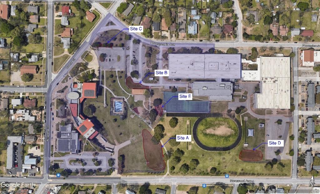
- Kealing Park Water Quality Project
-
The project will improve water quality for the Poquito Tributary of Boggy Creek. It will treat parking lot and roof runoff associated with the George Washington Carver Museum, Cultural and Genealogy Center, Carver Library, Kealing Neighborhood Park, and Kealing Middle School.
The project aims to be a showpiece for green infrastructure and provide educational and recreational benefits to visitors of the Carver Museum and Library, neighborhood residents, and students of Kealing Middle School.
Watershed
Poquito Tributary to Boggy Creek
Location
Most of the improvements are located on the grounds of Kealing Park.
Project Phases
The construction will likely occur in 2 phases. View this map to see the location of the different sites.
Phase 1
- Site A: Retrofit of existing detention pond at Kealing Park to include water quality measures. This pond when full will be a maximum of 2 feet deep and will drain within 48 hours. We are also proposing some recreational amenities, including a limestone block climbing feature for children.
- Site B: Retrofit of existing detention pond that serves the Kealing Middle School to include water quality measures. When full, this pond will be a maximum of 2 feet deep and drain within 48 hours.
- Site C: This would be a new rain garden at the northwest corner of the site to treat stormwater coming from Pennsylvania Ave. The new rain garden would have a 7.5 inch ponding depth and will also drain within 48 hours.
Phase 2
- Site D: Repair erosion issues at the existing biofilter that treats stormwater from the school on the southeast corner of the site.
- Site E: Repair the inlet of the existing rain garden that treats stormwater coming from the tennis court.
Status
This project is currently in design with construction estimated to begin in 2026.
Documents
Questions?
- Kshitiz Gyawali, Project Sponsor, 512-974-3345, or email Kshitiz
- Upper Waller Creek Drainage Improvements
-
This project aims to improve quality of life, the environment and drainage infrastructure. We will use greenspace along Northcrest Blvd. to expand neighborhood access to the creek, provide recreational opportunities, enhance stormwater treatment and reduce flood risk. The project includes:
- A 12-foot wide multi-purpose trail
- Rain gardens
- Grow zones to allow diverse, native vegetation and trees to become established on either side of the creek.
- New native plantings to increase wildlife habitat and reduce maintenance
- Step pools and a drop structure to protect the creek banks from erosion and provide wildlife habitat
- Dedicated clean-out areas for maintenance and sediment removal
- Dedicated clean-out areas provide for less damage to plants and habitat when regular
Watershed
Waller Creek
Location
The main project area runs along Northcrest Boulevard between West St. Johns Avenue and West Croslin Street. View project map.
Status
This project is currently in the design phase and has received a permit. Construction is dependent upon the availability of funding. To be added to the email distribution list, please email WPDPIO.
Documents
- English Factsheet: Upper Waller Creek Drainage Improvement Project
- Spanish Factsheet: Proyecto de drenaje para mejorar Upper Waller Creek
- November 2024 Presentation: Northcrest Drainage Improvements
- View recording of November 2024 meeting
- Community Survey Results, Summer 2022
Questions
- Drew Sloat, Project Sponsor, 512-974-2707 or email Drew.
- West Austin Park Water Quality Improvements
-
This project includes installing a biofiltration pond in West Austin Park. The project will naturally treat stormwater runoff, removing 7,000 pounds of sediment and pollutants every year. The stormwater comes from 24 acres of land near the park and flows through the park into Lady Bird Lake. The project will also enlarge the playing field, improve the park entrance and bring new plantings and vegetation. The project includes:
- Installing a biofiltration pond that will double as a playing field
- Replacing the existing 9th Street curb inlet
- Repairing hillside erosion caused by stormwater flowing from 9-½ street
- Upgrading the sidewalk and streetscape along 9th Street
- Repairing the failing historic walls in the park
- Replacing the old wastewater line that runs through the park
- Installing approximately 700 feet of new, ADA- accessible concrete trail
Please note that Lady Bird Lake is affected by development that pre-dates water quality regulations, which means polluted water flows into the lake. The lack of undeveloped land near the lake makes it challenging to find other locations for water quality treatment.
Watershed
Lady Bird Lake
Location
West Austin Park and 9th Street.
Status
This project is currently in design. We anticipate construction beginning in 2026 or 2027.
Documents
Questions?
Please reach out to one of the following people:
- Kshitiz Gyawali, Project Sponsor, 512-974-3345, or email Kshitizi
- Mel Fuechec, Project Manager, 512-974-5635 or email Mel
Don't see your project? It may be considered an erosion, local flood or creek flood project. A complete list of Capital Improvement Program projects is available on Capital Project Explorer.
- See a list of our projects with web pages
- Go to Capital Project Explorer
- Explore map of projects by Council District
Projects on Hold
Please note that the following projects have been put on hold indefinitely due to lack of funding, lack of community support or other issues:
- Reed Park Water Quality Improvements
-
This project would have featured the installation of a biofiltration field in Reed Park. It would have doubled as a playing field during dry weather conditions. This would have improved water quality in Taylor Slough South, one of Austin’s creeks most in need of restoration. The Texas Commission of Environmental Quality has classified it as one of four impaired creeks in Austin.
The project would also have reduced erosion and restored the natural habitat of the channel through the park. Other proposed improvements included replacement of the wastewater line that runs through the park. Trail improvements would have included an ADA-accessible pathway around the proposed facility and access to the footbridge on the northwest corner of the park.
Watershed
Taylor Slough South Watershed
Location
Within Reed Park
Status
On hold indefinitely due to community feedback. Despite our best efforts, we were unable to identify a feasible project that successfully balanced water quality improvements with community priorities and site constraints.
How to Help Improve Water Quality
There are two suspected sources for water quality issues in Taylor Slough:
- Untreated stormwater runoff
- Possible leaks from old wastewater infrastructure.
Residents can make a meaningful difference through small-scale, sustainable practices on their own properties. These include installing rain gardens, harvesting rainwater, using eco-friendly landscaping practices, and properly disposing of pet waste.
- Explore Austin Water rebates for sustainable gardening practices
- Read about installing a rain garden (PDF)
- Read about cisterns (PDF)
Please also consider checking for leaks on your property from your private wastewater lateral. This is the pipe connecting your home’s plumbing to the City’s wastewater system.
Questions
Please reach out to:
- Kshitiz Gyawali, Project Sponsor, 512-574-6566 or email Kshitiz