Click below to jump to a section.
Adopted Neighborhood Planning Areas | Neighborhood Plan Contact Teams | Neighborhood Plan Amendment | Neighborhood Planning Resources
Adopted Neighborhood Planning Areas
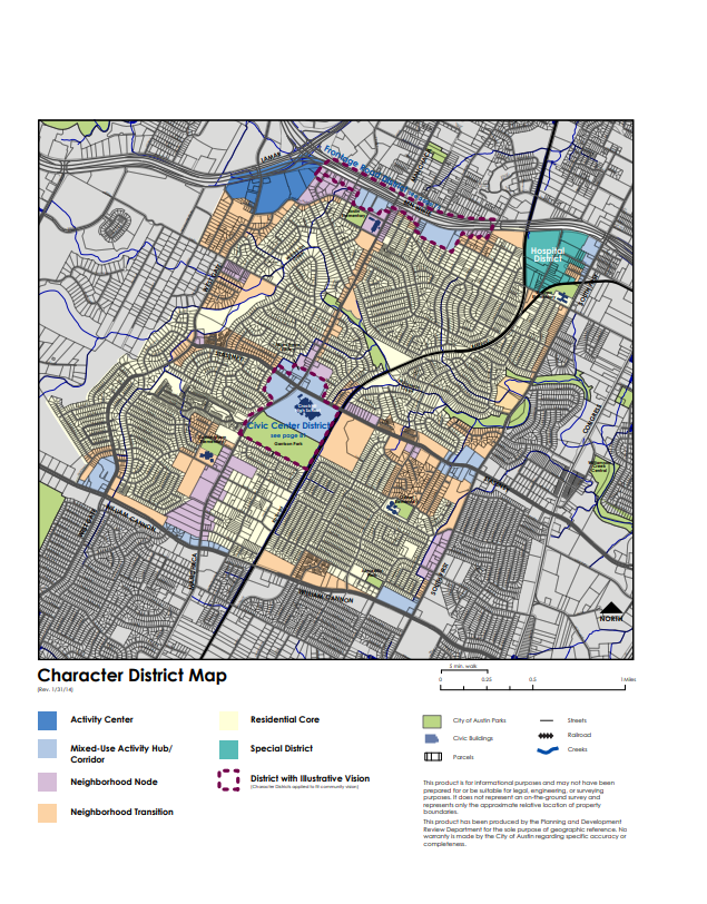
Neighborhood planning provides an opportunity for community members to shape the neighborhoods where they live, work or own property, while addressing land use, zoning, transportation and urban design issues. Click on the Official City Map (PDF) or the ArcGIS Map (Web) to see the Adopted Neighborhood Planning Areas.
The following section provides neighborhood plans, future land use maps (FLUMs), contact team information and related plan amendments (ordinance numbers) for specific planning areas.
- Bouldin Creek
-
Latest Information
Staff is currently working to provide updates on this Neighborhood Plan. Please check back soon.
High Level Neighborhood Plan Info
Neighborhood Plan: Bouldin Creek (PDF)
Adopted: May 23, 2002
Summary: The Bouldin Creek Neighborhood Plan is an amendment to the CIty of Austin's Comprehensive Plan. The plan's PDF contains information related to the planning process, 4 goals, and implementation all related to the plan.
Amendments: Cases (PDF)
Neighborhood Plan Contact Info
Primary Contact: Contact Team (Web)
Bylaws: Bylaws (PDF)
Neighborhood Plan Boundary
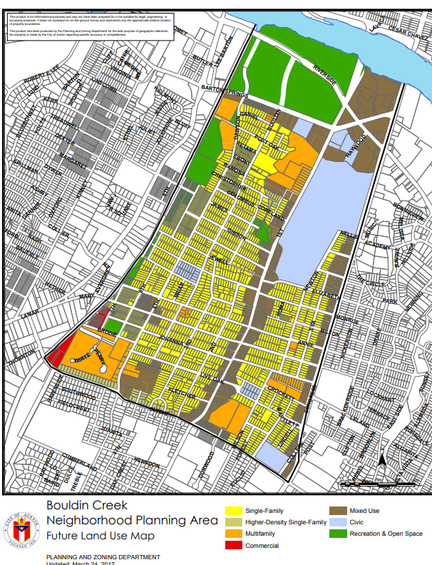
Future Land Use Map: FLUM (PDF)
Neighborhood Plan Recommendations
Recommendation: Implementation Chart (PDF)
- Brentwood/ Highland Combined
-
Latest Information
Staff is currently working to provide updates on this Neighborhood Plan. Please check back soon.
High Level Neighborhood Plan Info
Neighborhood Plan: Brentwood/ Highland Combined (PDF)
Adopted: May 13, 2004
Summary: The Brentwood/ Highland Combined Plan is an amendment to the City of Austin's Comprehensive Plan. The plan's PDF contains information such as vision and goals, priorities, history, land use, transportation, urban design and guidelines all related to the plan.
Amendments: Cases (PDF)
Neighborhood Plan Contact Info
Primary Contact: Contact Team (PDF)
Brentwood Neighborhood Plan Contact Team Bylaws: Bylaws (PDF)
Highland Neighborhood Plan Contact Team Bylaws: Bylaws (PDF)
Neighborhood Plan Boundary
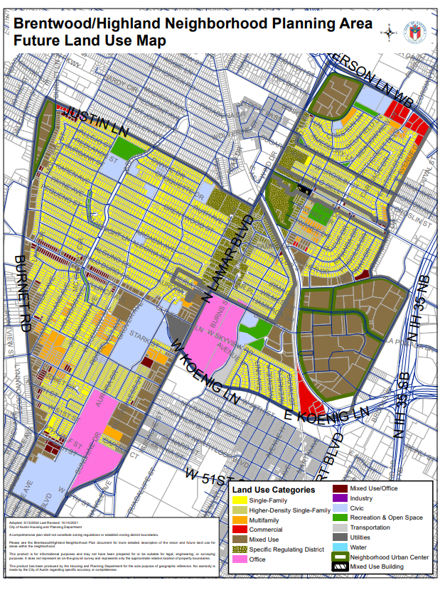
Future Land Use Map: FLUM (PDF)
Neighborhood Plan Recommendations
Recommendation: Implementation Chart (PDF)
- Central Austin Combined (CANPAC: West University, North University, Hancock)
-
Latest Information
Staff is currently working to provide updates on this Neighborhood Plan. Please check back soon.
High Level Neighborhood Plan Info
Neighborhood Plan: Central Austin Combined (PDF)
Adopted: August 26, 2004
Summary: The Central Austin Combined Neighborhood Plan spans the West University, North University, and Hancock areas. The plan's PDF contains information such as the plan's vision and goals, priorities, history, transportation, design guidelines and appendices all related to the plan.
Amendments: Cases (PDF)
Neighborhood Plan Contact Info
Primary Contact: Contact Team (PDF)
Bylaws: Bylaws (PDF)
Neighborhood Plan Boundary
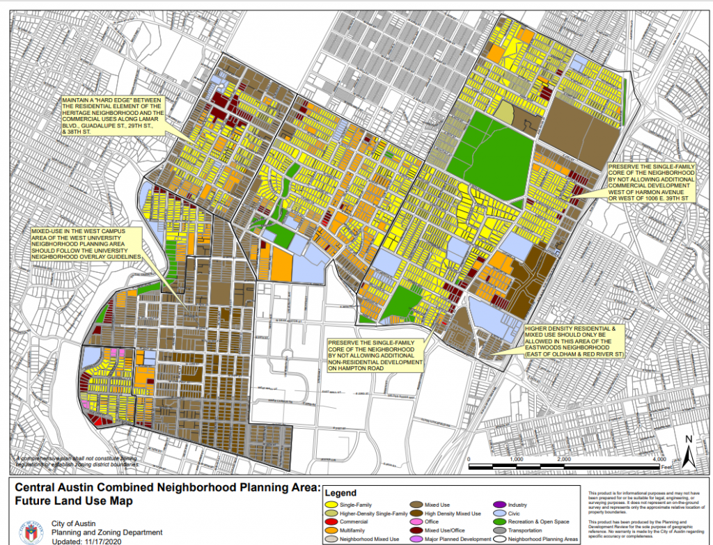
Future Land Use Map: FLUM (PDF)
Neighborhood Plan Recommendations
Recommendation: Implementation Chart (PDF)
- Central East Austin (OCEAN)
-
Latest Information
Staff is currently working to provide updates on this Neighborhood Plan. Please check back soon.
High Level Neighborhood Plan Info
Neighborhood Plan: Central East Austin (PDF)
Adopted: December 13, 2001
Summary: The Central East Austin (OCEAN) Neighborhood Combined Plan is an amendment to the City of Austin's Comprehensive Plan. The plan's PDF contains information on planning goals and priorities, historic preservation, housing, transportation, implementation of the plan and related appendices all related to the plan.
Amendments: Cases (PDF)
Neighborhood Plan Contact Info
Primary Contact: Contact Team (Web)
Bylaws: Bylaws (PDF)
Neighborhood Plan Boundary
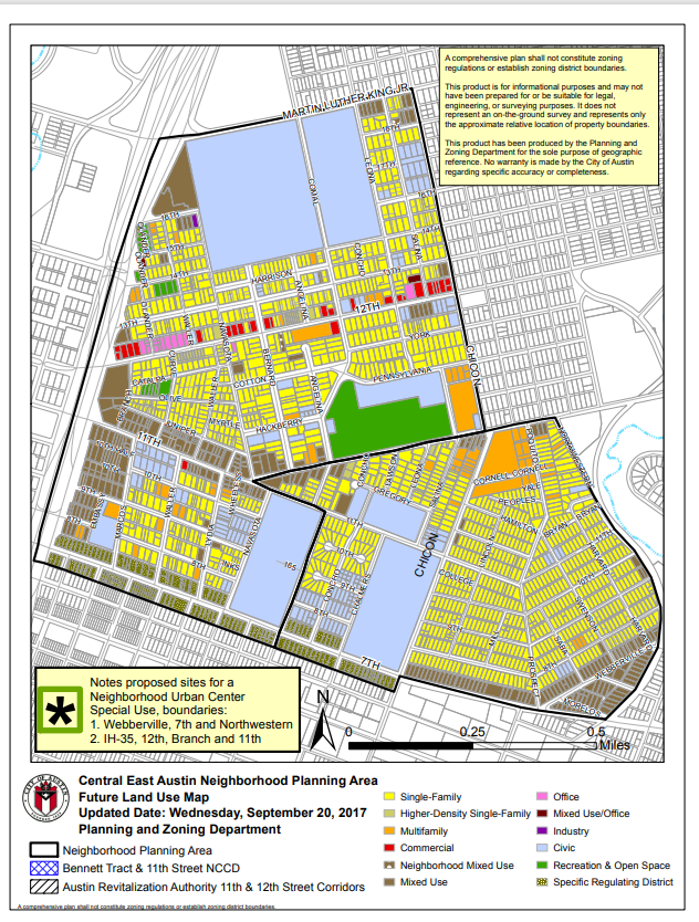
Future Land Use Map: FLUM (PDF)
Neighborhood Plan Recommendations
Recommendation: Implementation Chart (PDF)
- Central West Austin Combined (West Austin Neighborhood Group, Windsor Road)
-
Latest Information
Staff is currently working to provide updates on this Neighborhood Plan. Please check back soon.
High Level Neighborhood Plan Info
Neighborhood Plan: Central West Austin (PDF)
Adopted: September 2010
Summary: The Central West Austin Neighborhood Plan is an amendment to the City of Austin's Comprehensive Plan. The plan's PDF contains information such as a plan summary, the planning process, land use, transportation, recreational areas, community life and next steps all related to the plan.
Amendments: Cases (PDF)
Neighborhood Plan Contact Info
Primary Contact: Contact Team (Web)
Bylaws: Bylaws (PDF)
Neighborhood Plan Boundary
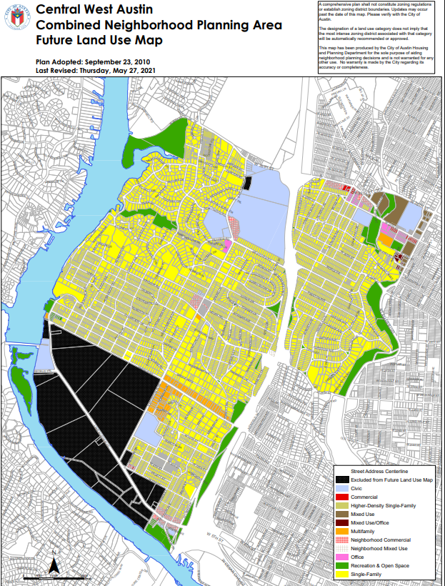
Future Land Use Map: FLUM (PDF)
Neighborhood Plan Recommendations
Recommendation: Implementation Chart (PDF)
- Chestnut
-
Latest Information
Staff is currently working to provide updates on this Neighborhood Plan. Please check back soon.
High Level Neighborhood Plan Info
Neighborhood Plan: Chestnut (PDF)
Adopted: July 15, 1999
Summary: The Chestnut Neighborhood Plan is an Amendment to the City of Austin's Neighborhood Plan. The Plan's PDF contains information such as goals and recommendations, land use and transportation, recreational areas, housing, economic development, public safety and implementation all related to the plan.
Amendments: Cases (PDF)
Neighborhood Plan Contact Info
Primary Contact: Contact Team (Web)
Bylaws: Bylaws (PDF)
Neighborhood Plan Boundary
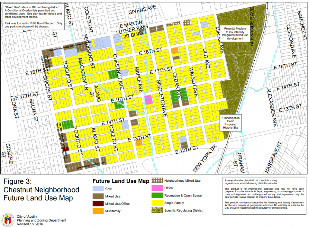
Future Land Use Map: FLUM (PDF)
Neighborhood Plan Recommendations
Recommendation: Implementation Chart (PDF)
- Crestview/Wooten Combined
-
Latest Information
Staff is currently working to provide updates on this Neighborhood Plan. Please check back soon.
High Level Neighborhood Plan Info
Neighborhood Plan: Crestview/Wooten Combined (PDF)
Adopted: April 1, 2004
Summary: The Crestview/ Wooten Combined Neighborhood Plan is an amendment to the City of Austin's Comprehensive Plan. The plan's PDF contains information such as vision and goals, top action items, historic preservation, recommendations, urban design and appendices all related to the plan.
Amendments: Cases (PDF)
Neighborhood Plan Contact Info
Primary Contact: Contact Team (Web)
Bylaws: Crestview Bylaws (PDF), Wooten Bylaws (PDF)
Neighborhood Plan Boundary
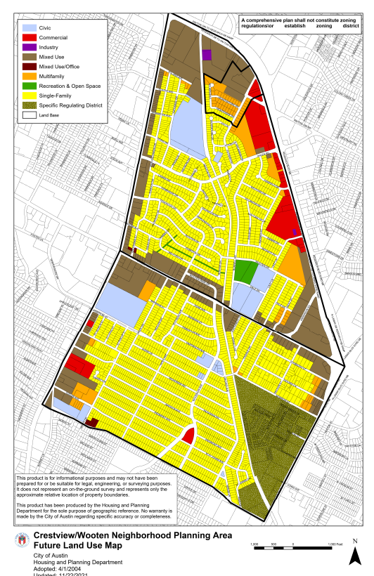
Future Land Use Map: FLUM (PDF)
Neighborhood Plan Recommendations
Recommendation: Implementation Chart (PDF)
- Dawson
-
Latest Information
Staff is currently working to provide updates on this Neighborhood Plan. Please check back soon.
High Level Neighborhood Plan Info
Neighborhood Plan: Dawson (PDF)
Adopted: August 27, 1998
Summary: The Dawson Neighborhood Plan is an amendment to the City of Austin's Comprehensive Plan. The plan's PDF contains information such as mission and goals, the planning process, neighborhood use, safety and health, business and commerce, transportation and implementation related to the plan.
Amendments: Cases (PDF)
Neighborhood Plan Contact Info
Primary Contact: Contact Team (Web)
Bylaws: Bylaws (PDF)
Neighborhood Plan Boundary
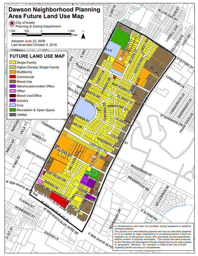
Future Land Use Map: FLUM (PDF)
Neighborhood Plan Recommendations
Recommendation: Implementation Chart (PDF)
- East Cesar Chavez
-
Latest Information
Staff is currently working to provide updates on this Neighborhood Plan. Please check back soon.
High Level Neighborhood Plan Info
Neighborhood Plan: East Cesar Chavez (PDF)
Adopted: May 13, 1999
Summary: The East Cesar Chavez Neighborhood Plan is an amendment to the City of Austin's Comprehensive Plan. The Plan's PDF contains information related to planning goal, critical development issues, neighborhood visions, the neighborhood plan, the process and implementation all related to the plan.
Amendments: Cases (PDF)
Neighborhood Plan Contact Info
Primary Contact: Contact Teams (Web)
Bylaws: Bylaws (PDF)
Neighborhood Plan Boundary
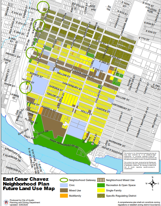
Future Land Use Map: FLUM (PDF)
Neighborhood Plan Recommendations
Recommendation: Implementation Chart (PDF)
- East MLK Combined (MLK, MLK-183, Pecan Springs, Springdale)
-
Latest Information
Staff is currently working to provide updates on this Neighborhood Plan. Please check back soon.
High Level Neighborhood Plan Info
Neighborhood Plan: East MLK Combined (PDF)
Adopted: November 7, 2002
Summary: The East MLK Neighborhood Plan is an amendment to the City of Austin's Comprehensive Plan. The plan's PDF contains information such as vision and goals, top action items, planning process, history, urban design, goals and objectives, implementation and appendices all related to the plan.
Amendments: Cases (PDF)
Neighborhood Plan Contact Info
Primary Contact: Contact Team (Web)
Bylaws: Bylaws (PDF)
Neighborhood Plan Boundary
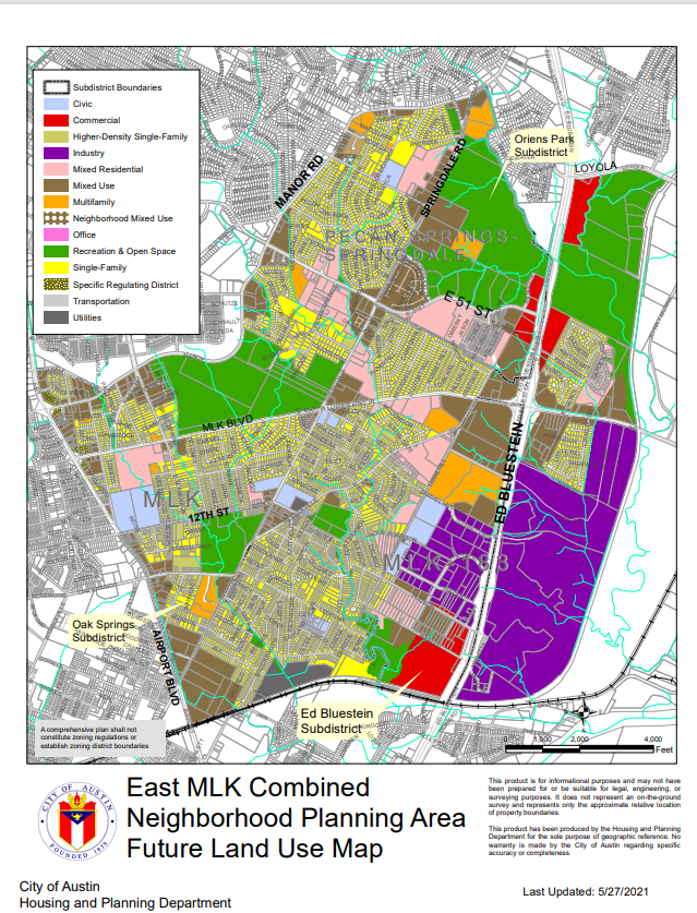
Future Land Use Map: FLUM (PDF)
Neighborhood Plan Recommendations
Recommendation: Implementation Chart (PDF)
- East Riverside/Oltorf Combined (Parker Lane, Pleasant Valley, Riverside)
-
Latest Information
Staff is currently working to provide updates on this Neighborhood Plan. Please check back soon.
High Level Neighborhood Plan Info
Neighborhood Plan: East Riverside/Oltorf Combined (PDF)
Adopted: November 16, 2006
Summary: The East Riverside/Oltorf Combined Neighborhood Plan is an amendment to the City's Comprehensive Plan. The Plan's PDF contains information such as an introduction with the vision, a statistical profile, goals and recommendations, land use, transportation, recreational areas, urban design and appendices all related to the plan.
Amendments: Cases (PDF)
Neighborhood Plan Contact Info
Primary Contact: Contact Team (Web)
Bylaws: Bylaws (PDF)
Neighborhood Plan Boundary
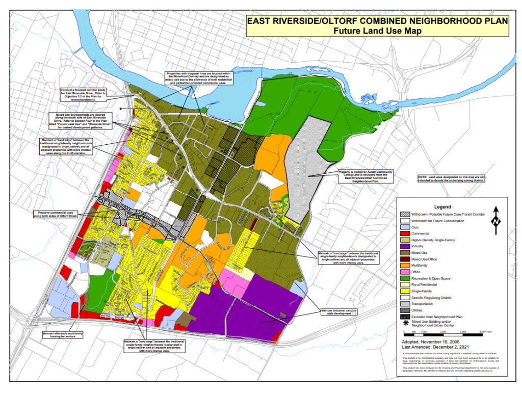
Future Land Use Map: FLUM (PDF)
Neighborhood Plan Recommendations
Recommendation: Implementation Chart (PDF)
- Govalle/ Johnston Terrace
-
Latest Information
Staff is currently working to provide updates on this Neighborhood Plan. Please check back soon.
High Level Neighborhood Plan Info
Neighborhood Plan: Govalle/ Johnston Terrace (PDF)
Adopted: March 27, 2003
Summary: The Govalle/ Johnston Neighborhood Plan is an amendment to the City of Austin's Comprehensive Plan. The Plan's PDF includes info on goals, top action items, land use, housing, transportation, infrastructure, recreational areas, environment, economic development, design guidelines and appendices all related to the plan.
Amendments: Cases (PDF)
Neighborhood Plan Contact Info
Primary Contact: Contact Team (Web)
Bylaws: Bylaws (PDF)
Neighborhood Plan Boundary
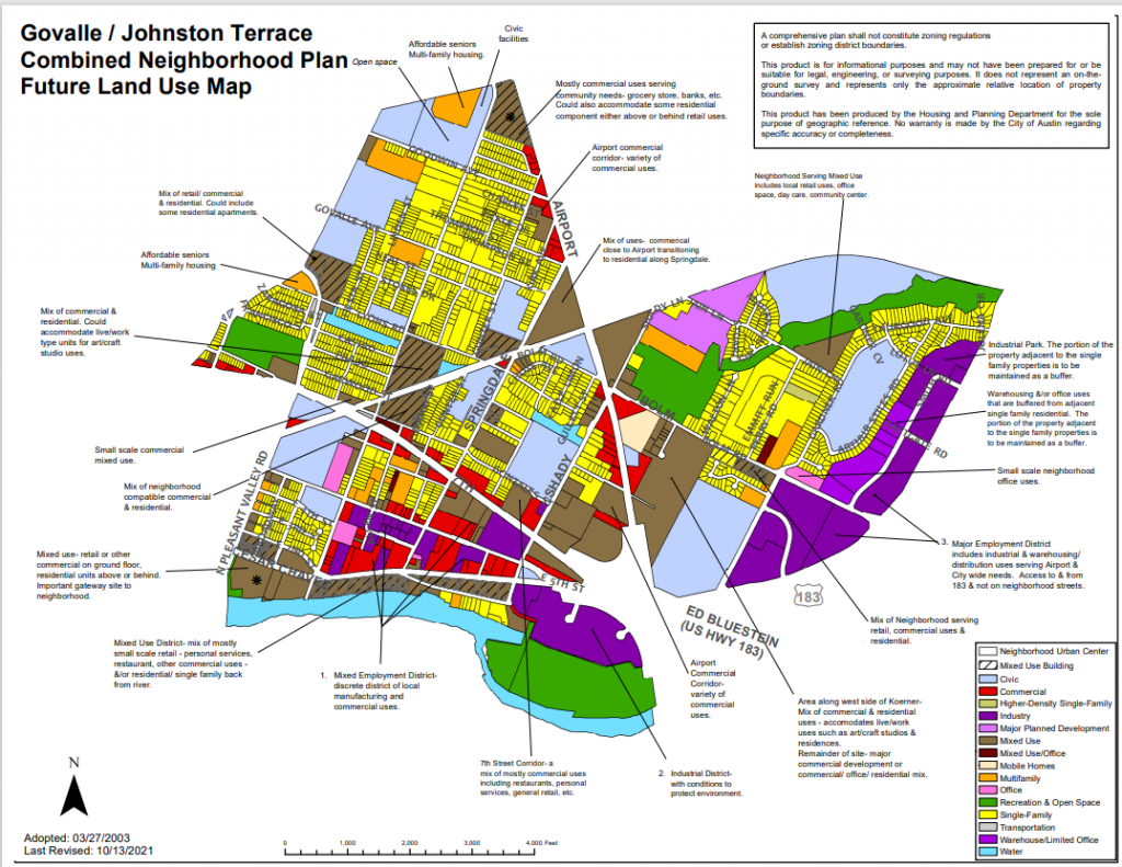
Future Land Use Map: FLUM (PDF)
Recommendation: Implementation Chart (PDF)
- Greater South River City
-
Latest Information
Staff is currently working to provide updates on this Neighborhood Plan. Please check back soon.
High Level Neighborhood Plan Info
Neighborhood Plan: Greater South River City (PDF)
Adopted: September 29, 2005
Summary: The Greater South River City Neighborhood Plan includes the areas South River City and St. Edwards. The Plan's PDF contains information related to vision and goals, top ten priorities, neighborhood profile, goals and recommendations, urban design and appendices all related to the plan.
Amendments: Cases (PDF)
Neighborhood Plan Contact Info
Primary Contact: Contact Team (Web)
Bylaws: Bylaws (PDF)
Neighborhood Plan Boundary
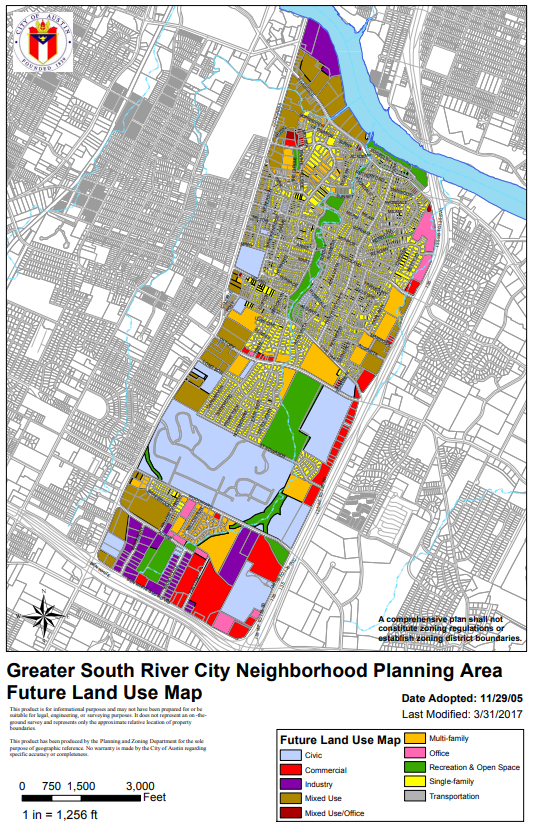
Future Land Use Map: FLUM (PDF)
Neighborhood Plan Recommendations
Recommendation: Implementation Chart (PDF)
- Heritage Hills/ Windsor Hills
-
Latest Information
Staff is currently working to provide updates on this Neighborhood Plan. Please check back soon.
High Level Neighborhood Plan Info
Neighborhood Plan: Heritage Hills/ Windsor Hills (PDF)
Adopted: January 2011
Summary: The Heritage Hills/ Windsor Hills Combined Neighborhood Plan is an amendment to the City of Austin's Comprehensive Plan. The Plan's PDF includes information on the planning process, vision and goals, land use, community life, recreation, transportation and infrastructure and appendices all related to the plan.
Amendments: Cases (PDF)
Neighborhood Plan Contact Info
Primary Contact: Contact Team (Web)
Bylaws: Bylaws (PDF)
Neighborhood Plan Boundary
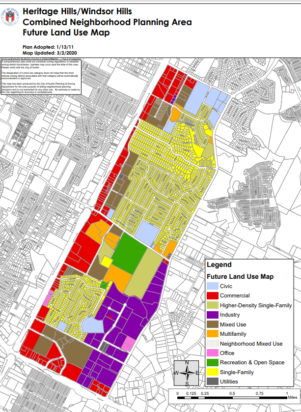
Future Land Use Map: FLUM (PDF)
Neighborhood Plan Recommendations
Recommendation: Implementation Chart (PDF)
- Holly
-
Latest Information
Staff is currently working to provide updates on this Neighborhood Plan. Please check back soon.
High Level Neighborhood Plan Info
Neighborhood Plan: Holly (PDF)
Adopted: December 13, 2001
Summary: The Holly Neighborhood Plan is an amendment to the City of Austin's Comprehensive Plan. The Plan's PDF contains an introduction, historical review, outreach efforts, top ten action items, land use information and objectives all related to the plan.
Amendments: Cases (PDF)
Neighborhood Plan Contact Info
Primary Contact: Contact Team (Web)
Bylaws: N/A
Neighborhood Plan Boundary
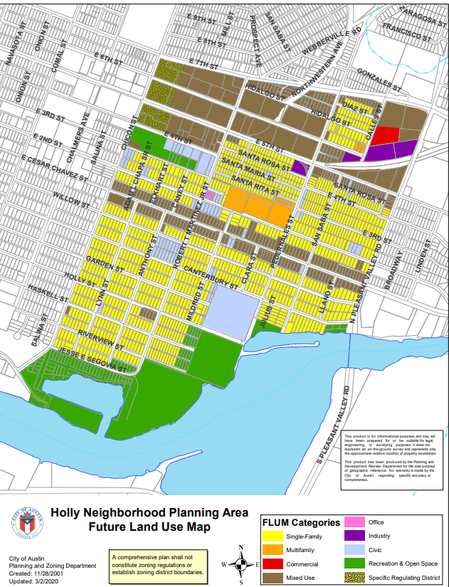
Future Land Use Map: FLUM (PDF)
Neighborhood Plan Recommendations
Recommendation: Implementation Chart (PDF)
- Hyde Park
-
Latest Information
Staff is currently working to provide updates on this Neighborhood Plan. Please check back soon.
High Level Neighborhood Plan Info
Neighborhood Plan: Hyde Park (PDF)
Adopted: April 13, 2000
Summary: The Hyde Park Neighborhood Plan is an amendment to the City of Austin's Comprehensive Plan. The plan's PDF contains a base map, summary, mission and goals, top ten priorities and implementation info all related to the plan.
Amendments: Cases (PDF)
Neighborhood Plan Contact Info
Primary Contact: Contact Team (Web)
Bylaws: Bylaws (PDF)
Neighborhood Plan Boundary
Future Land Use Map: N/A
Neighborhood Plan Recommendations
Recommendation: Implementation Chart (PDF)
- Montopolis
-
Latest Information
Staff is currently working to provide updates on this Neighborhood Plan. Please check back soon.
High Level Neighborhood Plan Info
Neighborhood Plan: Montopolis (PDF)
Adopted: September 27, 2001
Summary: The Montopolis Plan is an amendment to the City of Austin’s Comprehensive Plan. The plan’s PDF contains 3 chapters including: 1) Montopolis Planning Process, 2) The Montopolis Plan (including maps) and 3) Implementation. This plan includes maps.
Amendments: Cases (PDF)
Neighborhood Plan Contact Info
Primary Contact: Contact Team (Web)
Bylaws: Bylaws (PDF)
Neighborhood Plan Boundary
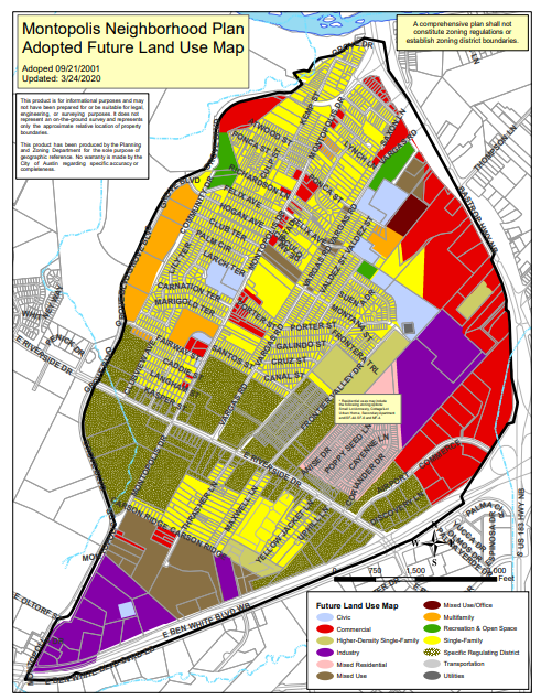
Future Land Use Map: FLUM (PDF)
Neighborhood Plan Recommendations
Recommendation: Implementation Chart (PDF)
- North Austin Civic Association
-
Latest Information
Staff is currently working to provide updates on this Neighborhood Plan. Please check back soon.
High Level Neighborhood Plan Info
Neighborhood Plan: North Austin Civic Association (NACA) (PDF)
Adopted: June 29, 2000
Summary: The North Austin Civic Association (NACA) Plan is an amendment to the City of Austin’s Comprehensive Plan. The plan’s PDF contains 5 chapters including: 1) Executive Summary, 2) Neighborhood Description, 3) Neighborhood Plan (including maps), 4) Neighborhood Design Guidelines, 5) Implementation. This plan includes maps.
Amendments: Cases (PDF)
Neighborhood Plan Contact Info
Primary Contact: Contact Team (Web)
Bylaws: Bylaws (PDF)
Neighborhood Plan Boundary
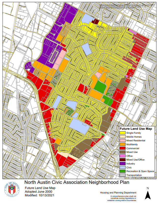
Future Land Use Map: FLUM (PDF)
Neighborhood Plan Recommendations
Recommendation: Implementation Chart (PDF)
- North Burnet/Gateway
-
Latest Information
Staff is currently working to provide updates on this Neighborhood Plan. Please check back soon.
High Level Neighborhood Plan Info
Neighborhood Plan: North Burnet/Gateway (Master Plan) (PDF)
Adopted: November 1, 2007
Summary: The North Burnet/ Gateway Plan (PDF) contains 7 chapters including: 1) Contents, 2) Introduction, 3) Existing Conditions, 4) Public Involvement, 5) Future Plan, 6) Implementation, and Appendices. The plan contains a 2035 conceptual plan and map.
Amendments: Cases (PDF)
Neighborhood Plan Contact Info
Primary Contact: NA
Bylaws: NA
Neighborhood Plan Boundary
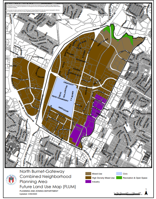
Future Land Use Map: FLUM (PDF)
Neighborhood Plan Recommendations
Recommendation: N/A
- North Lamar Combined (North Lamar, Georgian Acres)
-
Latest Information
Staff is currently working to provide updates on this Neighborhood Plan. Please check back soon.
High Level Neighborhood Plan Info
Neighborhood Plan: North Lamar Combined (PDF) (Georgian Acres, North Lamar)
Adopted: June 24, 2010
Summary: The North Lamar Combined Plan contains 9 chapters including: 1) Introduction, 2) The Neighborhood in Context, 3) Quality of Life, 4) Parks and Trees, 5) Transportation, 6) Land Use, 7) Conclusion, 8) Appendices. This plan includes maps.
Amendments: Cases (PDF)
Neighborhood Plan Contact Info
Primary Contact: N/A
Bylaws: N/A
Neighborhood Plan Boundary
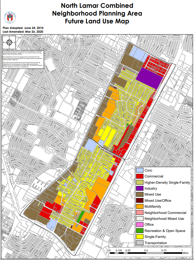
Future Land Use Map: FLUM (PDF)
Neighborhood Plan Recommendations
Recommendation: Implementation Chart (PDF)
- North Loop
-
Latest Information
Staff is currently working to provide updates on this Neighborhood Plan. Please check back soon.
High Level Neighborhood Plan Info
Neighborhood Plan: North Loop (PDF)
Adopted: May 23, 2002
Summary: The North Loop Plan is an amendment to the City of Austin’s Comprehensive Plan. The plan’s PDF provides information on the Planning Area (including maps), Neighborhood Planning Goals, Statistical Data, Land Use, and Appendices. This plan includes maps.
Amendments: Cases (PDF)
Neighborhood Plan Contact Info
Primary Contact: Contact Team (Web)
Bylaws: Bylaws (PDF)
Neighborhood Plan Boundary
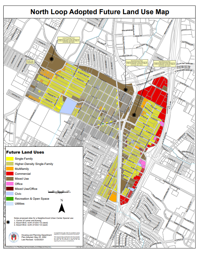
Future Land Use Map: FLUM (PDF)
Neighborhood Plan Recommendations
Recommendation: Implementation Chart (PDF)
- North Shoal Creek
-
Latest Information
Staff is currently working to provide updates on this Neighborhood Plan. Please check back soon.
High Level Neighborhood Plan Info
Neighborhood Plan: North Shoal Creek (PDF)
Adopted: August 23, 2018
Summary: The North Shoal Creek Plan (PDF) provides information related to Plan Context, Demographic Trends, Plan Implementation, and Future Land Use Maps. This plan includes maps.
Amendments: N/A
Neighborhood Plan Contact Info
Primary Contact: Contact Team (Web)
Bylaws: Bylaws (PDF)
Neighborhood Plan Boundary
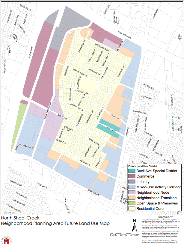
Future Land Use Map: FLUM (PDF)
Neighborhood Plan Recommendations
Recommendation: Implementation Chart (PDF)
- Oak Hill Combined (East Oak Hill, West Oak Hill)
-
Latest Information
Staff is currently working to provide updates on this Neighborhood Plan. Please check back soon.
High Level Neighborhood Plan Info
Neighborhood Plan: Oak Hill Combined (PDF) (East Oak Hill, West Oak Hill)
Adopted: December 11, 2008
Summary: The Oak Hill Combined Plan is an amendment to the City of Austin’s Comprehensive Plan. The plan’s PDF provides the following information: Overview, the Planning Process, Land Use and Development, Transportation, Housing, Community Life, Plan Implementation and Appendices. This plan includes maps.
Amendments: Cases (PDF)
Neighborhood Plan Contact Info
Primary Contact: Contact Team (Web)
Bylaws: Bylaws (PDF)
Neighborhood Plan Boundary
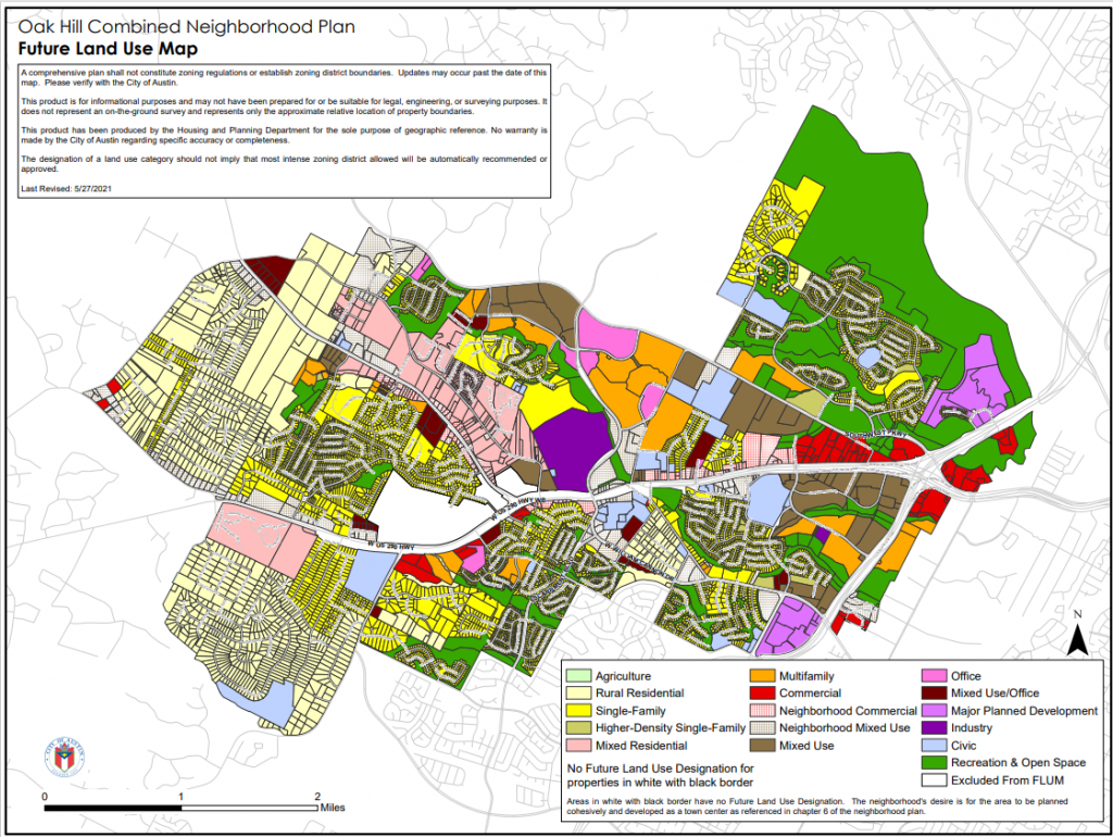
Future Land Use Map: FLUM (PDF)
Neighborhood Plan Recommendations
Recommendation: Implementation Chart (PDF)
- Old West Austin
-
Latest Information
Staff is currently working to provide updates on this Neighborhood Plan. Please check back soon.
High Level Neighborhood Plan Info
Neighborhood Plan: Old West Austin (PDF)
Adopted: June 29, 2000
Summary: The Old West Austin Plan is an amendment to the City of Austin’s comprehensive plan. The plan’s PDF contains information on Land Use and Zoning, Transportation, Parks and Recreation, Historic Preservation/ Urban Design, and Implementation. Maps on land use are included.
Amendments: Cases (PDF)
Neighborhood Plan Contact Info
Primary Contact: Contact Team (Web)
Bylaws: Bylaws (PDF)
Neighborhood Plan Boundary
Future Land Use Map: N/A
Neighborhood Plan Recommendations
Recommendation: Implementation Chart (PDF)
- Rosewood
-
Latest Information
Staff is currently working to provide updates on this Neighborhood Plan. Please check back soon.
High Level Neighborhood Plan Info
Neighborhood Plan: Rosewood (PDF)
Adopted: November 29, 2001
Summary: The Rosewood Neighborhood Plan is an amendment to the City of Austin’s Comprehensive Plan. The plan’s PDF contains information on the Planning Process, Neighborhood History, Planning Goals, Implementation and Appendices. This document includes maps.
Amendments: Cases (PDF)
Neighborhood Plan Contact Info
Primary Contact: Contact Team (Web)
Bylaws: Bylaws (PDF)
Neighborhood Plan Boundary
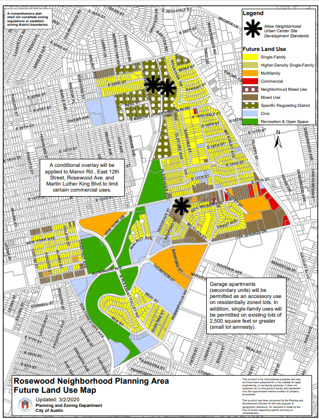
Future Land Use Map: FLUM (PDF)
Neighborhood Plan Recommendations
Recommendation: Implementation Chart (PDF)
- South Austin Combined (Westgate, South Menchaca, Garrison Park)
-
Latest Information
Staff is currently working to provide updates on this Neighborhood Plan. Please check back soon.
High Level Neighborhood Plan Info
Neighborhood Plan: South Austin Combined (PDF) (Westgate, South Manchaca, Garrison Par
Adopted: November 6, 2014
Summary: The South Austin Combined plan’s PDF contains information on the following: Plan Overview, Transportation, Neighborhood Character, Environment, Community Life and Appendix. This document includes maps.
Amendments: Cases (PDF)
Neighborhood Plan Contact Info
Primary Contact: South Manchaca Contact Team (Web), Westgate Contact Team (Web)
Bylaws: South Manchaca Bylaws (PDF), Westgate Bylaws (PDF)
Neighborhood Plan Boundary
Future Land Use Map: FLUM (PDF)
Neighborhood Plan Recommendations
Recommendation: Implementation Chart (PDF)
- South Congress Combined (East Congress, Sweetbriar, West Congress)
-
Latest Information
Staff is currently working to provide updates on this Neighborhood Plan. Please check back soon.
High Level Neighborhood Plan Info
Neighborhood Plan: South Congress Combined (PDF) (East Congress, Sweetbriar, West Congress
Adopted: August 18, 2005
Summary: The South Congress Combined Neighborhood Plan is an amendment to the City of Austin’s Comprehensive Plan. The plan’s PDF contains information on the following: the Neighborhood Planning Area, Visions and Goals, Top Ten Priorities, History of the Area, Five Main Goals, South Congress Design Guidelines and appendices. This plan includes maps.
Amendments: Cases (PDF)
Neighborhood Plan Contact Info
Primary Contact: Contact Team (Web)
Bylaws: Bylaws (PDF)
Neighborhood Plan Boundary
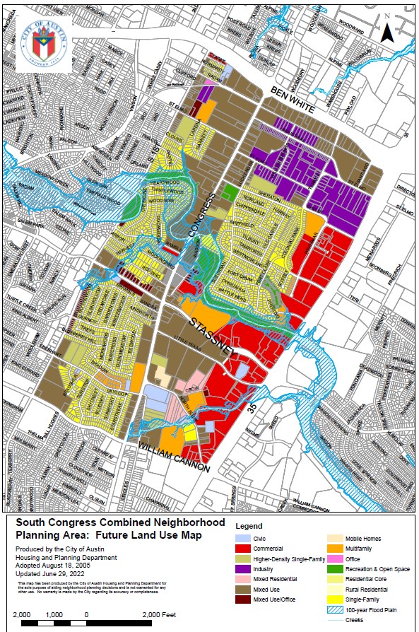
Future Land Use Map: FLUM (PDF)
Neighborhood Plan Recommendations
Recommendation: Implementation Chart (PDF)
- St. John/Coronado Hills Combined
-
Latest Information
Staff is currently working to provide updates on this Neighborhood Plan. Please check back soon.
High Level Neighborhood Plan Info
Neighborhood Plan: St. John/Coronado Hills Combined (PDF)
Adopted: April 26, 2012
Summary: The St. John/Cornado Hills Plan is an amendment to the City of Austin’s Comprehensive Plan. The plan’s PDF contains information on the following: Plan Summary, Planning Area Context, Planning Process, Community Life, Recreational Area, Transportation, Land Use, Next Steps, and Appendices. This plan includes maps.
Amendments: Cases (PDF)
Neighborhood Plan Contact Info
Primary Contact: St. John Contact Team (Web), Coronado Hills Contact Team (Web)
Bylaws: St. John Bylaws (PDF), Coronado Hills Bylaws (PDF)
Neighborhood Plan Boundary
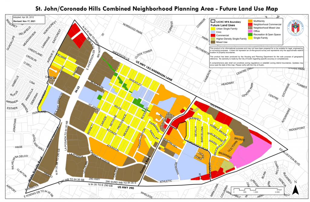
Future Land Use Map: FLUM (PDF)
Neighborhood Plan Recommendations
Recommendation: Implementation Chart (PDF)
- Southeast Combined (Franklin Park, McKinney, Southeast)
-
Latest Information
Staff is currently working to provide updates on this Neighborhood Plan. Please check back soon.
High Level Neighborhood Plan Info
Neighborhood Plan: Southeast Combined (PDF) (Franklin Park, McKinney, Southeast)
Adopted: October 10, 2002
Summary: The Southeast Combined Neighborhood Plan is an amendment to the City of Austin’s Comprehensive Plan. The plan’s PDF provides information on the following: Neighborhood Planning Area Vision, Neighborhood Goals, Top Ten Action Items, Demographics, Goals, Implementation, and Appendices. This plan includes maps.
Amendments: Cases (PDF)
Neighborhood Plan Contact Info
Primary Contact: Contact Team (PDF)
Bylaws: Bylaws (PDF)
Neighborhood Plan Boundary
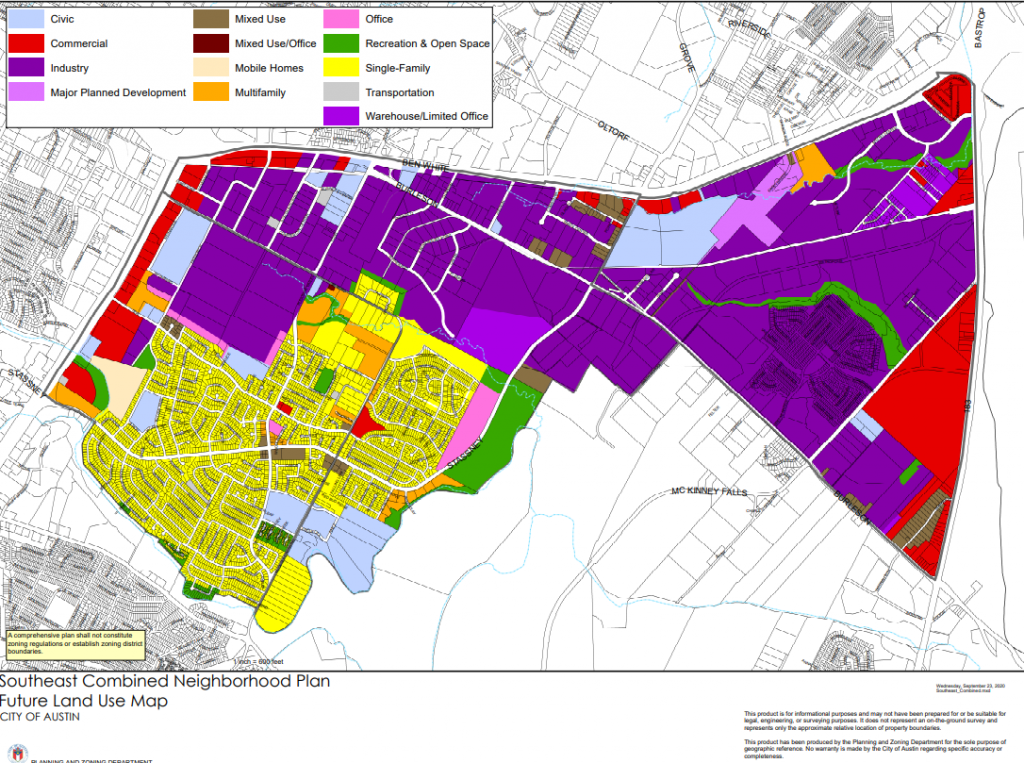
Future Land Use Map: FLUM (PDF)
Neighborhood Plan Recommendations
Recommendation: Implementation Chart (PDF)
- University Hills/ Windsor Park
-
Latest Information
Staff is currently working to provide updates on this Neighborhood Plan. Please check back soon.
High Level Neighborhood Plan Info
Neighborhood Plan: University Hills/Windsor Park - (Part 1) (PDF)/ University Hills/Windsor Park - (Part 2) (PDF)/ University Hills/Windsor Park - (Part 3) (PDF)
Adopted: August 9, 2007/ NA/ August 10, 2007
Summary: The University Hills/ Windsor Park Neighborhood Plan includes the following information related to the plan: Land Use and Development, Housing, Recreation, Transportation, Community Life, and Appendices. This plan includes maps.
Amendments: Cases (PDF)
Neighborhood Plan Contact Info
Primary Contact: University Hills Contact Team (Web), Windsor Park Contact Team (Web)
Bylaws: University Hills Bylaws (PDF), Windsor Park Bylaws (PDF)
Neighborhood Plan Boundary
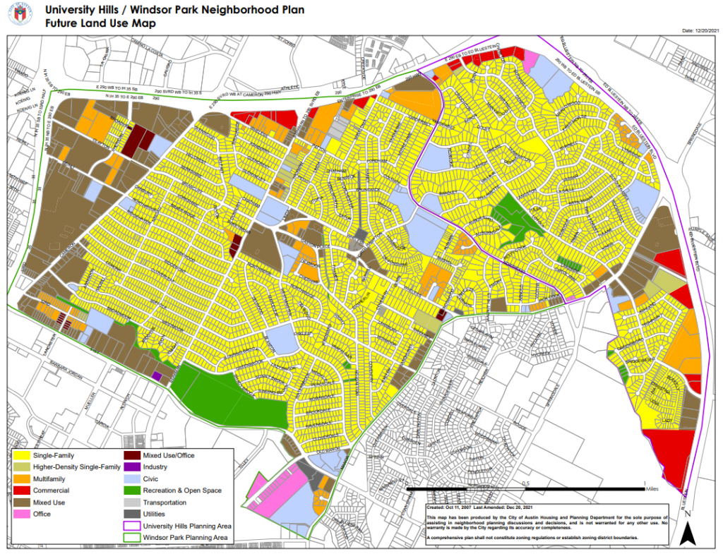
Future Land Use Map: FLUM (PDF)
Neighborhood Plan Recommendations
Recommendation: Implementation Chart (PDF)
- Upper Boggy Creek
-
Latest Information
Staff is currently working to provide updates on this Neighborhood Plan. Please check back soon.
High Level Neighborhood Plan Info
Neighborhood Plan: Upper Boggy Creek (PDF)
Adopted: August 1, 2002
Summary: The Upper Boggy Creek Plan (PDF) includes the following information: Neighborhood Area Planning Base Map, Neighborhood Profile, History, Goals, and Appendices. This plan includes maps.
Amendments: Cases (PDF)
Neighborhood Plan Contact Info
Primary Contact: Contact Team (Web)
Bylaws: Bylaws (PDF)
Neighborhood Plan Boundary
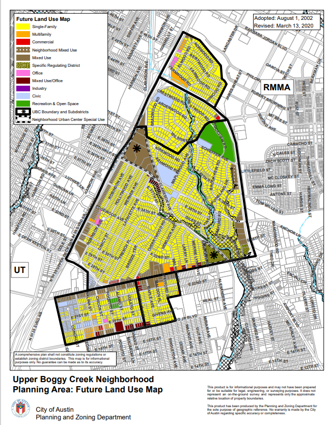
Future Land Use Map: FLUM (PDF)
Neighborhood Plan Recommendations
Recommendation: Implementation Chart (PDF)


The following links may be useful for individuals seeking more information related to the Adopted Neighborhood Planning Areas:
Neighborhood Plan Contact Teams
A Neighborhood Plan Contact Team (NPCT) is a group of individuals designated to be the stewards or advocates of their adopted neighborhood plan. They work with city staff towards the implementation of the plan recommendations, review and initiate plan amendments, serve as community points of contact, and work on behalf of other neighborhood stakeholders.
Stakeholders who live in the planning area either through renting or owning their home, business owners, property owners and neighborhood organization representatives who live in the planning area are welcome to participate on the Contact Team.
To learn about legal representation for Neighborhood Contact Teams please visit the City Law Department Memo (PDF) regarding contact teams and legal representation- May 18, 2010.
To search the Community Registry database to find or update contact team information please visit the Community Registry (Web).
More information on Neighborhood Plan Contact Teams is available at Austin Land Development Code Section 25-1-801 (Web).
Contact Team Resources
The following links may be useful for individuals seeking more information related to Neighborhood Plan Contact Teams:
- Neighborhood Plan Contact Team Dispute Resolution Instructions (PDF)
- Neighborhood Plan Contact Team Dispute Resolution Complaint Form (PDF)
- Bylaws Template (PDF)
- Bylaws Template Instructions (PDF)
- An Overview of Neighborhood Planning (PDF)
- Contact Team FAQs (PDF)
- Contact Team Role in Plan Amendments (PDF)
- How to Write a Plan Amendment Recommendation (PDF)
- Plan Amendment Application for Neighborhood Plan Contact Teams (PDF)
- Land Use and Zoning (PDF)
- Community Organizing (PDF)
- Housing & Planning Staff Resources (PDF)
Neighborhood Plan Amendment
A neighborhood plan amendment (NPA) allows for changes to be made to an adopted neighborhood plan and/or future land use map (FLUM). A plan amendment is required if a proposed zoning change is inconsistent with the plan’s FLUM. The plan amendment process ensures that stakeholders in the neighborhood and the neighborhood plan contact team will be notified of proposed amendments.
Please visit Public Input - Neighborhood Plan Amendment Cases (Web) for more information.
Neighborhood Planning Resources
This section provides information on land use and zoning, neighborhood plan amendments, front or side yard parking, and mobile food establishments.
- Land Use and Zoning Materials
-
The following resources may help individuals seeking Land Use and Zoning Materials.
- Guide to Land Use Standards (PDF)- Explains land use planning and describes land use categories. (Updated Feb 2024)
- Guide to Zoning (PDF)- Zoning districts and permitted use within the districts. (Updated Sept 2016)
- Zoning Districts by Land Use (PDF)- Zoning districts allowed under each land use category. A new map designation, “Specific Regulating District” is for areas with adopted regulating plans.
- Infill Options & Design Tools Booklet (PDF)- Contains summary charts of infill options/design tools for adopted neighborhood plans and explanation of infill options/design tools. (Updated May 2017)
- Design Tools Map (PDF)- Shows Impervious Cover/Parking Placement, Garage Placement, and Front Porch design tools that are available subdistrict or area-wide.
- Infill Options Map for Neighborhood Planning Areas (PDF)- Shows which infill options are available in adopted neighborhood planning areas on a (planning) area-wide, subdistrict, or parcel basis.
- Land Use/Zoning Matrix (PDF)- This chart shows when a proposed zoning change application triggers a plan amendment application when the property is located within a City Council-approved neighborhood plan that has a future land use map.
- Application for Neighborhood Plan Amendment
-
A Neighborhood Plan Amendment (NPA) allows for changes to be made to an adopted neighborhood plan and/or future land use map (FLUM).
- Individual property owners requesting site-specific neighborhood plan amendments should fill out and submit the Neighborhood Plan Amendment Application for Property Owners (PDF).
- Neighborhood Plan Contact Teams requesting amendments to their plan should fill out and submit the Neighborhood Plan Amendment Application for Neighborhood Plan Contact Team (PDF).
The Neighborhood Plan Amendment Applications provide additional information about the requirements related to Neighborhood Plan Amendments.
- New Additional Resources for Neighborhoods
-
- APD District Representatives (Web)
- Common Code Violations (Web)
- Community Registry (Web)
- Composting (Web)
- Homeless & Special Needs Assistance (Web)
- Music/ Amplified Sound Permits (Web)
- Neighborhood Assistance Center (Web)
- Neighborhood Partnering Program (Web)
- Residential Permit Parking (Web)
- Zoning (Web)
- Neighborhood Applications for Mobile Food Establishments
-
Resources for Mobile Food Vendors
Mobile Food Establishments (Food Trailers) are licensed and regulated by Austin Public Health (Web) (City of Austin Code Sections 10-3-91 thru 10-3-95). If you need health permit assistance, please contact Environmental Health Services at 512-978-0300.
Austin Public Health's Mobile Food Vendors (Web) provides applications and guides for mobile food vendors. Mobile Food Establishments (Food Trailers) and operational requirements are defined in Section 10-3-1 of the Austin City Code.
For applications and guides for mobile food vendors, please visit Austin Public Health's Mobile Food Vendors (Web). Mobile Food Establishments (Food Trailers) and operational requirements are defined in Section 10-3-1 of the Austin City Code.
Resources for Neighborhoods Seeking to Apply
The Planning and Zoning Department is responsible for the application process for neighborhoods that wish to adopt more restrictive regulations relating to the distance and hours of operation of mobile food trailers operating near neighborhoods.
For areas with a City Council-approved neighborhood plan, the Planning Contact Team must submit the application. For areas without a City Council-approved neighborhood plan, the neighborhood association can submit the application.
The application period is the month of February of each year. The application must be hand-delivered or postmarked no later than February 28th of each year. Click to learn more about the application process (PDF).
- How to complete the MFV Additional Regulations Application (Web/ Video)
- MFV Additional Regulations Application (PDF)
- Zoning and Site development regulations: Section 25-2-812 (Sections B-K) (Web) of the City of Austin Code.
Mobile Food Establishment Requirements
Neighborhood Plan Contact Teams and Neighborhood Associations may adopt more restrictive regulations for hours of operation and distance to residences each February.
Applications/Maps
- Application Process and List of Additional Requirements (Section L-O) for Neighborhood Plan Contact Teams or Neighborhood Associations (Web)
- Application for Additional Regulations (PDF)
- Map of Neighborhoods with Additional Requirements (PDF)
- Mobile Food Establishments FAQ's (PDF)
- Central Austin Combined Neighborhood Planning Area (PDF)
- Proposed Area to be included for 2024 (PDF)
- Neighborhood Applications for Restricted Front and Side Yard Parking
-
The application period is the month of February of each year. The Restricted Front/Side Yard Parking application must be hand-delivered or postmarked no later than February 28th of each year.
View the Front Yard Parking Map to show areas that have adopted the Restricted Front and Side Yard Parking Ordinance.