
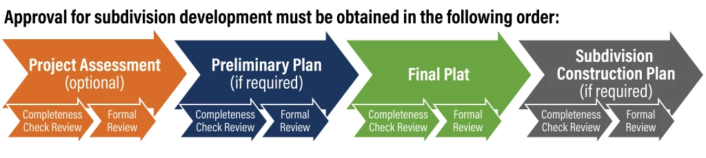
Subdivision Application Process
Important Update: Austin Development Services has made important changes to the Subdivision development process. Please review each section's information carefully, as the process and many applications and web forms have changed.
According to Section 212.004 of the Texas Local Government Code (TLGC), the subdivision of land is required when a property owner, within the City limits or extraterritorial jurisdiction (ETJ), divides a tract of land into two or more parts for the purpose of sale, development, or extension of utilities to the property to be subdivided. Additional types of subdivisions include combining platted lots and/or portions of lots or unplatted land into new lots by resubdivision, adjusting lot lines between existing legal lots by amended plat, or vacation of plats.
A subdivision is not zoning. If the owner wants to change the permitted land uses on a property in the City limits, the developer may have to go through the rezoning process. A subdivision is not a site plan or building permit and does not authorize the construction, demolition, or relocation of buildings or any site construction.
What you will find on this page:
- Land Status Determination (Exception from Platting)
- Time-Sensitive Requirements
- Project Assessments
- Preliminary Plans
- Final Plats
- Subdivision Construction Plans
- Subdivision Vacations
- Forms and Applications
- HB 3167 and 3699: Overview
- City and County Coordination
- Austin Development Services Reviews and Resources
- Partner Department Reviews and Resources
- Formal Submittal Calendar for Final Plat and Preliminary Plan Applications
- Fees and Online Tools
- Appointments
Subdivision Development Processes
- Land Status Determination (Platting Exception)
Chapter 25-4-2 of the City of Austin Land Development Code lists the requirements needed to obtain an exception from platting through an application known as a Land Status Determination. A Land Status Determination is an official determination made by the City of Austin that exempts unplatted or illegally platted tracts of land from the State platting requirements.
State Law prohibits the connection of utility services to a lot that is not legally platted (i.e. a subdivision recorded in the County records.) Additionally, the City of Austin Land Development Code requires Subdivision approval to precede the issuance of Building Permits and/or Site Plans. The Code provides exceptions from this requirement which are reviewed through the Land Status Determination process.
How to Apply
The applicant listed on the application must have an AB+C Portal account to pay fees and manage the application. If you do not have an AB+C Portal account, please register for an AB+C Portal account here. For additional assistance, please see the AB+C Manual. Please make a note of the email address used for this new account. You will need this for the next step.
Step 1: Determine if You Qualify
To determine if your tract may qualify for the Land Status Determination, use our Land Status Determination Tool. Schedule a Land Status Determination appointment if you need assistance with the tool or need additional information.
Land Status Determination Tool
If you do not qualify, schedule a Land Status Determination appointment with Subdivision staff to discuss how to move forward. Do not continue with the following steps.
If you do qualify, go to the next step.
Step 2: Submit an Application through the AB+C Portal
If you believe your tract qualifies for Land Status Determination, submit the following through your Austin Build + Connect (AB+C) account.
- Completed Land Status Determination Application (PDF)
- Supplemental documents listed on the Land Status Determination Tool
Step 3: Application Review & Pay Invoice
Staff will review the request to confirm all information and documents needed for review have been provided. If additional information is needed, staff will contact the applicant via email. Once everything has been provided, the invoice will be issued to the applicant and will need to be paid. Visit the Cashier Services webpage to view the payment options. You may need to notify your reviewer via email once the payment is made.
Step 4: Application Results
Review staff will email the applicant within ten business days with a determination of approved or denied. If the Land Status Determination Application is denied, schedule a Land Status Determination appointment to discuss how to move forward.
- Time Sensitive Requirements
This list identifies some time-sensitive requirements that may be needed to approve an application for a preliminary plan, final plat, or subdivision construction plan. These items are not required to be submitted for the Completeness Check Review process, but they may be required for approval of a subdivision application. To maximize ease of review, applicants are encouraged to provide all applicable documents when submitting for the Completeness Check Review process.
- General
- Final City Council approval of any proposed zoning application.
- Final determination for Chapter 245 vested rights, or applicability of “other” rules. Visit the Vested Rights webpage to learn more.
- Parkland final determination or Early Determination (PED) letter. Submit a request for a PED.
- Driveway/Utility Plan for residential flag lots. Approved by: Austin Fire, Austin Energy, Austin Water, Transportation and Public Works, Environmental, City Arborist, Subdivision, Drainage, and Water Quality.
- Alternative Method of Compliance (AMOC) from Austin Fire for urban, cottage, or small lots (only in full-purpose jurisdiction).
- A non-standard legal document(s) reviewed and approved by the Austin City Attorney's Office.
- Approved Land Management agreements (License Agreement and/or Encroachment approved by City Council). Visit the Land Development Engineering webpage to learn more.
- Approved variance from the Board of Adjustment for lot size or lot width.
- Engineer’s sealed fiscal cost estimate.
- If any portion of the plat is in the Hays County ETJ, Hays County must approve the plat before submitting it to the City of Austin.
- Drainage / Floodplain / RSMP
- Final determination for Alternative Equivalent Compliance (AEC) for Water Quality, including fee-in-lieu.
- Regional Stormwater Management Program (RSMP) participation letter. Visit the RSMP webpage to learn more.
- Floodplain variance approved by Council. Visit the Floodplain Regulations webpage to learn more.
- Final determination for any modification of the adopted COA Floodplain Hydraulic Model.
- Austin Utility Location and Coordination Committee (AUCCL) approval is needed before submittal of a subdivision construction plan. Visit the AULCC webpage to learn how to apply.
- Conditional Letter of Map Revision (CLOMR) for the proposed change to a FIRM Flood Insurance Rate Map (FIRM).
- Environmental
- Final determination for Save Our Springs (SOS) limited adjustment(s).
- Council approval of Save Our Springs (SOS) Redevelopment exception(s).
- Recommendation from Environmental Board for any environmental variances that require a public hearing.
- Transportation
- For Travis County ETJ only, an approved Traffic Impact Analysis (TIA). Visit Travis County’s TIA webpage to learn more.
- Driveway permit from TXDOT for any connection to a state Right of Way (ROW). Visit the TXDOT webpage. to learn more about Driveway permits.
- Driveway permit from Travis County for any connection to a county ROW. Visit the Travis County’s Driveway webpage to learn more.
- Utilities
- Approved Service Extension Request (SER) from Austin Water Utility for water, wastewater, or reclaimed water. Visit the Service Extension webpage to learn more.
- Will-Serve letter and capacity confirmation for Preliminary Plan not served by Austin Water.
- Formal Service Commitment confirmation for final plat not served by Austin Water.
- Letter of support from controlling easement owner (Austin Energy, Austin Water, Watershed Protection, etc.) for an Easement Vacation.
- Certificate of Convenience and Necessity (CCN) release.
- General
- Project Assessments

The Subdivision Project Assessment has been created to provide a high-level evaluation of the potential code compliance of a future subdivision application. In addition to providing requirements for the subdivision, a Project Assessment will evaluate potential issues for the project, provide a 180-day binding staff recommendation on any discretionary approvals, and answer any questions from the applicant.
Variances, Waivers, and Discretionary Approvals
The following list identifies some discretionary items that may be addressed through a Project Assessment.
- Regional Stormwater Management Program participation
- Alternative Equivalent Compliance for Water Quality
- Save Our Springs (SOS) limited adjustments; Redevelopment exceptions
- Floodplain
- Floodplain Variance (Council approval required)
- Delineation of Floodplain –if the application is proposing an independent study or not using the City delineation
- Modification of an adopted City of Austin Floodplain Hydraulic Model
- Conditional Letter of Map Revisions
- Letter of Map Revisions Variances from Land Development Code requirements
- Environmental, Save Our Springs (SOS) Amendment
- Subdivision
- Transportation
- Heritage Trees
- Any Utility Codes that allow formal variances
- Waivers and administrative variances from criteria, discretionary
- Flag lots (Title 25 only)
- Drainage Criteria Manual
- Transportation Criteria Manual
- Environmental Criteria Manual
- Protected Tree
- Fire – Alternative Method of Compliance (AMOC) tied to subdivision layout and right-of-way (ROW) widths, not limited to just small lots
- Utility Criteria Manual
- Non-standard legal documents and Real Estate applications
- Easement and ROW Vacation
- Encroachment Agreement (Council approval before formal submittal)
- License Agreement (Administrative approval)
- Parkland - Determination or verification of parkland dedication requirements
- Parkland - Chapter 26 – Recommended approval obtained before the filing of a Preliminary or Final Plat
- Cottage, Urban or Small lots in city limits that require an AMOC for Austin Fire approval
- Plat vacations
- Non-standard Retaining Walls for a Subdivision Construction Plan
How to Apply
The Applicant listed on the application must have an AB+C Portal account to pay fees and manage the application. If the applicant does not have an AB+C Portal account, please register for an AB+C Portal account as a first-time user. For additional assistance, please see the AB+C Manual, or call Austin 3-1-1. Please make a note of the email address used for this new account.
Step 1: Submit a Project Assessment Completeness Check Application Using the Web Form
Complete a Subdivision Project Assessment Completeness Check Application (PDF) and gather the required documents. Visit the Time Sensitive Requirements section to view possible items that can be addressed through a Project Assessment. We encourage you to utilize the Development Assessment meeting with Land Use Assistance (LUAssist) staff to better gauge possible requirements for both processes. Email DSDZoningSitePlan@austintexas.gov to request a Development Assessment meeting.
Submit your completed Application and supplemental documents using the Subdivision Completeness Check Application Web Form. Please note that the Completeness Check (CC) Review must be deemed complete within 45 days of the Filing Date; otherwise, the Completeness Check Application will expire.
Subdivision CC Application Web Form
Once you submit the application, you will receive an automatic email confirming your submission, including the approximate wait time.
Please do not resubmit a form, as this will create delays.
Step 2: Pay Invoice
Once the application is accepted for review, the applicant will receive an invoice for the Completeness Check fees. The invoice must be paid for the review process to begin. Visit the Cashier Services webpage to view the payment options.
Once the invoice is paid, your application will proceed to the 45-day Completeness Check Review period. The application Filing Date is one (1) business day after the invoice is paid.
Step 3: Completeness Check Review & Updates
During the Completeness Check (CC) Review, staff verifies that all required administrative and technical items have been submitted. At the end of the CC review (10 business days), staff sends a Completeness Check Result Letter.
If an application is deemed incomplete, please submit an update to the application using the Subdivision Completeness Check (CC) Application Web Form.
Step 4: Receive Completeness Check Certification Letter
Once the Completeness Check Application is deemed complete, the applicant will receive the Completeness Check Certification Letter. This letter is needed for the Subdivision Project Assessment Formal Application submittal and expires 45 calendar days after issuance.
The Formal Application submittal and payment of formal review fees must occur before the letter expires. Otherwise, a new Completeness Check Application will be required.
Step 5: Submit Project Assessment Formal Application & Pay Invoice
The following steps must be completed within 45 calendar days from the issuance of the Completeness Check Certification Letter:
- Submit the following documents using the Subdivision Formal Application Web Form and Receive the Invoice. Initial Subdivision Formal Applications may be submitted at any time. Once the Formal Application is accepted for review, the applicant will receive an invoice for the formal review fees. The required submittal items include:
- Completed Subdivision Project Assessment Formal Application (PDF).
Completeness Check Certification Letter. Letter received at the end of the Completeness Check Review process.
- Pay the invoice for the formal review fees. The applicant can view the fees through their AB+C Portal account. Visit the Cashier Services webpage to view the payment options.
- Staff will process the Subdivision Formal Application. One business day after the invoice is paid, your application will be processed and the Formal Review period will start.
Step 6: Formal Review & Updates
During the formal review, staff will review the project to ensure the plan or plat complies with the code. When the review is completed, staff will send a Master Comment Report to the applicant. If you have questions about the comments, contact the assigned reviewer noted in the Master Comment Report for clarification.
If comments note compliance deficiencies, submit an update to the plan or plat using the Subdivision Formal Application Web Form.
The following applies to updates to the Subdivision Formal Application.
- Updates must be submitted within six months (180 calendar days) after the Master Comment Report is issued.
- A review update may be submitted two times before a new application is required.
- Updates may be submitted at any time. Same-day update submittals must be submitted before 3 p.m. for same-day processing.
Subdivision Formal Application Web Form
Step 7: Receive Project Assessment Formal Review Results & Project Continuation
After the review is finished, a Master Comment Report is provided with all staff recommendations on the discretionary approval, variance, or waiver.
For staff’s recommendations in the Project Assessment to apply, a subdivision application must be accepted for review within 180 calendar days from the date the report was issued.
If you submit the next applicable Completeness Check Application for the project within 180 calendar days, you will also receive a 25% discount on Austin Development Services Formal Review fees.
To continue with your Subdivision project, please continue with the subsequent development processes.
- Preliminary Plans

A preliminary plan is a map or drawing of a proposed land partition and infrastructure development. Approval of the preliminary plan establishes a mutual commitment on the part of the City/County and the subdivider to the subdivision layout for final plat approval, including the location and width of streets, lots, blocks, and easements shown on the plan.
The most common proposed improvements that trigger a preliminary plan are the following:
- New public or private Right-of-Way (ROW)
- An extension of an existing public or private Right-of-Way (ROW)
Widening of existing ROW does not require a preliminary plan and can be accomplished with a dedication by plat or street deed. Refer to LDC Sec. 25-4-51 for details on what triggers a preliminary plan.
See the Subdivision Completeness Check Submittal Checklist (PDF) for a complete list of required and optional submittal items.
Revisions to Preliminary Plans
A change to an approved preliminary plan is classified as either a minor deviation or a minor revision.
Minor Deviation
Minor deviations are changes that do not increase development density or impervious cover. For example, shifting a lot line one foot to increase the size of a residential lot, but not the number of residential lots. Minor deviations are so minor that no application is required and are processed concurrently with the final plat.
Minor Revision
Minor revisions to an approved preliminary plan require an application and a fee. Approval of a preliminary plan revision does not change the expiration date from the original approved preliminary plan. The following are examples of minor revisions that would require an application for a revised preliminary plan:
- Street alignment changes and adding or deleting streets
- Converting a cul-de-sac to a through street or visa-versa
- Converting a public street into a private street
- Increase in the number of lots which increases the density or intensity of development
Any revision that goes beyond the scope of changes identified in Sec. 25-4-61 of the LDC requires a new preliminary plan.
How to Apply
The Applicant listed on the application must have an AB+C Portal account to pay fees and manage the application. If the applicant does not have an AB+C Portal account, please register for an AB+C Portal account as a first-time user. For additional assistance, please see the AB+C Manual, or call Austin 3-1-1. Please make a note of the email address used for this new account.
Step 1: Review & Complete Time Sensitive Requirements
See the Time Sensitive Requirements section to review for possible discretionary requirements. If applicable, obtain recommendations through a Project Assessment. Visit the Project Assessment section to learn more about this review process.
Step 2: Submit a Subdivision Completeness Check Application Using the Web Form
Complete a Subdivision Completeness Check Application (PDF) and gather the required documents. Please ensure all information is entered correctly and refer to the Subdivision Completeness Check Submittal Checklist (PDF) for required and optional submittal items.
We encourage you to utilize the Development Assessment meeting with Land Use Assistance (LUAssist) staff to better gauge possible requirements for both processes. Email DSDZoningSitePlan@austintexas.gov to request a Development Assessment meeting.
Submit your completed application and supplemental documents using the Subdivision Completeness Check (CC) Application Web Form.
PLEASE NOTE: The Completeness Check Review must be deemed complete within 45 days of the Filing Date; otherwise, the Completeness Check Application will expire.
Subdivision CC Application Web Form
Once you submit the application, you will receive an automatic email confirming your submission, including the approximate wait time.
Please do not resubmit a form, as this will create delays.
Step 3: Pay Invoice
Once your application is accepted for Completeness Check Review, the applicant will receive an invoice for the Completeness Check fees. The invoice must be paid within five business days of receipt for the Completeness Check Review process to begin. Visit the Cashier Services webpage to view the payment options.
Once the invoice is paid, your application will proceed to the 45-day Completeness Check Review period. The application Filing Date is one (1) business day after the invoice is paid.
Step 4: Completeness Check Review & Updates
During the Completeness Check (CC) Review, staff verifies that all required administrative and technical items have been submitted. Within ten (10) business days after the Filing Date, the applicant will receive a Completeness Check Results Letter noting any deficiencies in the form or content of your application.
If an application is deemed incomplete, please submit updates to provide additional information, documents, or corrections using the Subdivision Completeness Check (CC) Application Web Form.
For increased efficiency of the initial Formal Review, please provide any required Formal Review documentation during the Completeness Check review.
Subdivision CC Application Web Form
The Subdivision Completeness Check Application must be deemed complete within 45 days of the Filing Date; otherwise, it will expire.
Step 5: Receive Completeness Check Certification Letter
Once the Completeness Check Application is deemed complete, the applicant will receive the Completeness Check Certification Letter. This letter is needed for the Formal Application submittal.
The Formal Application submittal and payment of formal review fees must occur within 45 calendar days after issuance of the Certification Letter. Otherwise, a new Completeness Check Application will be required.
Step 6: Submit Subdivision Formal Application & Pay Invoice
The following steps must be completed within 45 calendar days from the issuance of the Completeness Check Certification Letter:
- Submit the following documents using the Subdivision Formal Application Web Form and Receive the Invoice. Initial Subdivision Formal Applications may be submitted at any time. Once the Formal Application is accepted for review, the applicant will receive an invoice for the formal review fees. The required submittal items include:
- Completed Subdivision Formal Applications (PDF).
- Completeness Check Certification Letter. Letter received at the end of the Completeness Check Review process.
Please be aware that no additional documentation can be submitted during the initial submittal of Formal Review. Additional documentation can be provided in subsequent updates.
- Pay the invoice for the Formal Review fees. The applicant can view the fees through their AB+C Portal account. Visit the Cashier Services webpage to view the payment options.
- Staff will process the Subdivision Formal Application. Once the invoice is paid, your application will proceed to Formal Review on the next Formal Submittal Day. The invoice must be paid before 3 p.m. on a Formal Submittal Day for same-day processing. When the application is processed for review, the Filing Date will start. View the Formal Submittal Calendar to determine the next available Formal Submittal Day.
Step 7: Initial Formal Review
During the Formal Review, staff will review the project to ensure the plan complies with the code. The initial review of a subdivision application will be provided 30 calendar days after the Filing Date.
When the review is completed, a Master Comment Report with a determination is provided to the applicant. If you have questions about the comments or need clarification, reach out to the assigned reviewer noted in the Master Comment Report.
Staff will make the following determination: “Approved”, “Approved with conditions”, or “Disapproved with reasons”.
Go to Step 8 if the application is “Approved with Conditions” or “Disapproved with reasons”.
Go to Step 9 if the application is “Approved”.
Step 8: Submit Updates to Subdivision Formal Application
If the application is “Approved with Conditions” or “Disapproved with reasons”, submit an update to your plan based on the recommendations in the Master Comment Report using the Subdivision Formal Application Web Form. The update review of the subdivision application will be provided 15 calendar days after the Formal Submittal Day.
The following applies to updates to a Subdivision Formal Application.
- Updates must be submitted by the Update Submittal deadline, which is six months (180 calendar days) from the Filing Date of the Formal Application.
- Updates may be submitted at any time. They will be processed on the next available Formal Submittal Day. Same-day update submittals must be submitted before 3 p.m. for same-day processing. View the Formal Submittal Calendar to determine the next available formal submittal day.
Subdivision Formal Application Web Form
For applications that are near their expiration date and may not be able to receive approval, contact the assigned Case Manager listed on the Master Comment Report for guidance on the next steps.
Step 9: Preliminary Plan Formal Review Results
Once the plans are approved by all review staff, the plans will be stamped with an approval date and a digital copy will be sent to the applicant electronically. The plans will also be uploaded to the AB+C Portal.
Please note that Final Plats must be approved and recorded before the expiration date of the preliminary plan. Approval of a preliminary plan revision does not change the expiration date from the original approved preliminary plan.
Step 10: Continue with Final Plat Process
Once the Preliminary Plan is approved, move forward with the Final Plat process. The Subdivision Construction process will also be required after the Final Plat process if the infrastructure is necessary to be constructed for the subdivision.
- Final Plats

A final plat is a map or drawing of a subdivision approved by the Land Use Commission or Department Director and recorded by the County Clerk. There are four basic types of final plats:
- Final Plat out of a Preliminary Plan
- Final Plat without a Preliminary Plan
- Amending Plat
- Resubdivision (Replat)
A Final Plat out of a Preliminary Plan must be recorded before the Preliminary Plan expiration date.
See the Subdivision Completeness Check Submittal Checklist (PDF) for a complete list of required and optional submittal items.
Amending Plats
An amended plat is used to make minor changes to existing legal lots. It cannot remove plat restrictions or require a variance.
The most common reasons for submitting a plat amendment are:
- To move a common lot line between platted lots
- To correct a Scrivener's error, clerical error, or omission (e.g., lot numbers, acreage, street names, adjacent plats)
Resubdivisions (Replat)
A resubdivision is a further division of all or part of a recorded, final plat.
An Amending Plat and Resubdivision of all or part of a recorded plat without vacating the preceding plat is possible if the following provisions are met per the Texas Local Government Code (TLGC Sec. 212):
- No restrictions or requirements are removed from the original final plat (e.g. building setback lines, notes, easements required for approval of the original plat, etc.)
- The plat is signed by all land owners of the resubdivision
How to Apply
The Applicant listed on the application must have an AB+C Portal account to pay fees and manage the application. If the applicant does not have an AB+C Portal account, please register for an AB+C Portal account as a first-time user. For additional assistance, please see the AB+C Manual, or call Austin 3-1-1. Please make a note of the email address used for this new account.
Step 1: Review & Complete Time Sensitive Requirements
See the Time Sensitive Requirements section to review for possible discretionary requirements. If applicable, obtain recommendations through a Project Assessment. Visit the Project Assessment section to learn more about this review process.
Step 2: Submit a Subdivision Completeness Check Application Using the Web Form
Complete a Subdivision Completeness Check Application (PDF) and gather the required documents. Please ensure all information is entered correctly and refer to the Subdivision Completeness Check Submittal Checklist (PDF) for required and optional submittal items.
We encourage you to utilize the Development Assessment meeting with Land Use Assistance (LUAssist) staff to better gauge possible requirements for both processes. Email DSDZoningSitePlan@austintexas.gov to request a Development Assessment meeting.
Submit your completed application and supplemental documents using the Subdivision Completeness Check (CC) Application Web Form.
PLEASE NOTE: The Completeness Check Review must be deemed complete within 45 days of the Filing Date; otherwise, the Completeness Check Application will expire.
Subdivision CC Application Web Form
Once you submit the application, you will receive an automatic email confirming your submission, including the approximate wait time.
Please do not resubmit a form, as this will create delays.
Step 3: Pay Invoice
Once your application is accepted for Completeness Check Review, the applicant will receive an invoice for the Completeness Check fees. The invoice must be paid within five business days of receipt for the Completeness Check Review process to begin. Visit the Cashier Services webpage to view the payment options.
Once the invoice is paid, your application will proceed to the 45-day Completeness Check Review period. The application Filing Date is one business day after the invoice is paid.
Step 4: Completeness Check Review & Updates
During the Completeness Check Review, staff verifies that all required administrative and technical items have been submitted. Within 10 business days after the Filing Date, the applicant will receive a Completeness Check Results Letter noting any deficiencies in the form or content of your application.
If an application is deemed incomplete, please submit updates to provide additional information, documents, or corrections using the Subdivision Completeness Check (CC) Application Web Form.
For increased efficiency of the initial Formal Review, please provide any required Formal Review documentation during the Completeness Check review.
Subdivision CC Application Web Form
The Subdivision Completeness Check Application must be deemed complete within 45 days of the Filing Date; otherwise, it will expire.
Step 5: Receive Completeness Check Certification Letter
Once the Completeness Check Application is deemed complete, the applicant will receive the Completeness Check Certification Letter. This letter is needed for the Formal Application submittal.
The Formal Application submittal and payment of formal review fees must occur within 45 calendar days after issuance of the Certification Letter. Otherwise, a new Completeness Check Application will be required.
Step 6: Submit Subdivision Formal Application & Pay Invoice
The following steps must be completed within 45 calendar days from the issuance of the Completeness Check Certification Letter:
- Submit the following documents using the Subdivision Formal Application Web Form and Receive the Invoice. Initial Subdivision Formal Applications may be submitted at any time. Once the Formal Application is accepted for review, the applicant will receive an invoice for the formal review fees. The required submittal items include:
- Completed Subdivision Formal Applications (PDF).
- Completeness Check Certification Letter. Letter received at the end of the Completeness Check Review process.
Please be aware that no additional documentation can be submitted during the initial submittal of Formal Review. Additional documentation can be provided in subsequent updates.
- Pay the invoice for the Formal Review fees. The applicant can view the fees through their AB+C Portal account. Visit the Cashier Services webpage to view the payment options.
- Staff will process the Subdivision Formal Application. Once the invoice is paid, your application will proceed to Formal Review on the next Formal Submittal Day. The invoice must be paid before 3 p.m. on a Formal Submittal Day for same-day processing. When the application is processed for review, the Filing Date will start. View the Formal Submittal Calendar to determine the next available Formal Submittal Day.
Step 7: Initial Formal Review
During the Formal Review, staff will review the project to ensure the plan complies with the code. The initial review of a subdivision application will be provided 30 calendar days after the Filing Date.
When the review is completed, a Master Comment Report with a determination is provided to the applicant. If you have questions about the comments or need clarification, reach out to the assigned reviewer noted in the Master Comment Report.
Staff will make the following determination: “Approved”, “Approved with conditions”, or “Disapproved with reasons”.
Go to Step 8 if the application is “Approved with Conditions” or “Disapproved with reasons”.
Go to Step 9 if the application is “Approved”.
Step 8: Submit Updates to Subdivision Formal Application
If the application is “Approved with Conditions” or “Disapproved with reasons”, submit an update to your plan based on the recommendations in the Master Comment Report using the Subdivision Formal Application Web Form. The update review of the subdivision application will be provided 15 calendar days after the Formal Submittal Day.
The following applies to updates to a Subdivision Formal Application.
- Updates must be submitted by the Update Submittal deadline, which is 6 months (180 calendar days) from the Filing Date of the Formal Application.
Updates may be submitted at any time. They will be processed on the next available Formal Submittal Day. Same-day update submittals must be submitted before 3 p.m. for same-day processing. View the Formal Submittal Calendar to determine the next available formal submittal day.
For applications that are near their expiration date and may not be able to receive approval, contact the assigned Case Manager listed on the Master Comment Report for guidance on the next steps.
Step 9: Final Plat Formal Review Results
Once the plat is approved, the recordation process begins, and if required, fiscal posting is due.
Fiscal posting is due 90 calendar days from the Update Deadline. Along with Fiscal, a Subdivision Construction Agreement must be submitted and approved. Visit the Fiscal Surety webpage to learn more.
Recordation is due 80 business days after plat approval. All items needed to record the plat must be submitted to the Case Manager by the close of the 80th business day. The Case Manager will complete the plat recordation with the County Clerk’s Office.

Step 10: Continue with Subdivision Construction Plan Process, if required
Once the Plat is recorded, the applicant can move forward with the Subdivision Construction process if infrastructure construction is necessary for the subdivision.
- Subdivision Construction Plans

Subdivision construction plans are drawings that include the infrastructure necessary for the construction of the subdivision, including, but not limited to, the following:
- Streets
- Drainage
- Water and wastewater
- Detention and water quality
- Environmental controls
- Protection of important environmental features and trees
A Subdivision Construction Plan is not a Building Permit and does not authorize the construction, demolition, or relocation of buildings.
See the Subdivision Completeness Check Submittal Checklist (PDF) for a complete list of required and optional submittal items.
How to Apply
The Applicant listed on the application must have an AB+C Portal account to pay fees and manage the application. If the applicant does not have an AB+C Portal account, please register for an AB+C account as a first-time user. For additional assistance, please see the AB+C Manual, or call Austin 3-1-1. Please make a note of the email address used for this new account.
Step 1: Review & Complete Time Sensitive Requirements
See the Time Sensitive Requirements section to review for possible discretionary requirements. If applicable, obtain recommendations through a Project Assessment. Visit the Project Assessment section to learn more about this review process.
Step 2: Submit a Subdivision Completeness Check Application Using the Web Form
Complete a Subdivision Completeness Check Application (PDF) and gather the required documents. Please ensure all information is entered correctly and refer to the Subdivision Completeness Check Submittal Checklist (PDF) for required and optional submittal items.
We encourage you to utilize the Development Assessment meeting with Land Use Assistance (LUAssist) staff to better gauge possible requirements for both processes. Email DSDZoningSitePlan@austintexas.gov to request a Development Assessment meeting.
Submit your completed application and supplemental documents using the Subdivision Completeness Check (CC) Application Web Form.
PLEASE NOTE: The Completeness Check Review must be deemed complete within 45 days of the Filing Date; otherwise, the Completeness Check Application will expire.
Subdivision CC Application Web Form
Once you submit the application, you will receive an automatic email confirming your submission, including the approximate wait time.
Please do not resubmit a form, as this will create delays.
Step 3: Pay Invoice
Once your application is accepted for Completeness Check Review, the applicant will receive an invoice for the Completeness Check fees. The invoice must be paid within five business days of receipt for the Completeness Check Review process to begin. Visit the Cashier Services webpage to view the payment options.
Once the invoice is paid, your application will proceed to the 45-day Completeness Check Review period. The application Filing Date is one business day after the invoice is paid.
Step 4: Completeness Check Review & Updates
During the Completeness Check Review, staff verifies that all required administrative and technical items have been submitted. Within 10 business days after the Filing Date, the applicant will receive a Completeness Check Results Letter noting any deficiencies in the form or content of your application.
If an application is deemed incomplete, please submit updates to provide additional information, documents, or corrections using the Subdivision Completeness Check (CC) Application Web Form.
For increased efficiency of the initial Formal Review, please provide any required Formal Review documentation during the Completeness Check review.
Subdivision CC Application Web Form
The Subdivision Completeness Check Application must be deemed complete within 45 days of the Filing Date; otherwise, it will expire.
Step 5: Receive Completeness Check Certification Letter
Once the Completeness Check Application is deemed complete, the applicant will receive the Completeness Check Certification Letter. This letter is needed for the Formal Application submittal.
The Formal Application submittal and payment of formal review fees must occur within 45 calendar days after issuance of the Certification Letter. Otherwise, a new Completeness Check Application will be required.
Step 6: Submit Subdivision Formal Application & Pay Invoice
The following steps must be completed within 45 calendar days from the issuance of the Completeness Check Certification Letter:
- Submit the following documents using the Subdivision Formal Application Web Form and Receive the Invoice. Initial Subdivision Formal Applications may be submitted at any time. Once the Formal Application is accepted for review, the applicant will receive an invoice for the formal review fees. The required submittal items include:
- Completed Subdivision Formal Applications (PDF).
- Completeness Check Certification Letter. Letter received at the end of the Completeness Check Review process.
Please be aware that no additional documentation can be submitted during the initial submittal of Formal Review. Additional documentation can be provided in subsequent updates.
- Pay the invoice for the Formal Review fees. The applicant can view the fees through their AB+C Portal account. Visit the Cashier Services webpage to view the payment options.
- Staff will process the Subdivision Formal Application. One business day after the invoice is paid, your application will be processed, and the Formal Review period will start. Same-day update submittals must be submitted before 3 p.m. for same-day processing. When the application is processed for review, the Filing Date will start.
Step 7: Initial Formal Review
During the Formal Review, staff will review the project to ensure the plan complies with the code. The initial review of a subdivision application will be provided 30 calendar days after the Filing Date.
When the review is completed, a Master Comment Report with a determination is provided to the applicant. If you have questions about the comments or need clarification, reach out to the assigned reviewer noted in the Master Comment Report.
Staff will make the following determination: “Approved”, “Approved with conditions”, or “Disapproved with reasons”.
Go to Step 8 if the application is “Approved with Conditions” or “Disapproved with reasons”.
Go to Step 9 if the application is “Approved”.
Step 8: Submit Updates to Subdivision Formal Application
If the application is “Approved with Conditions” or “Disapproved with reasons”, submit an update to your plan based on the recommendations in the Master Comment Report using the Subdivision Formal Application Web Form. The update review of the subdivision application will be provided 15 calendar days after the Formal Submittal Day.
The following applies to updates to a Subdivision Formal Application.
- Updates must be submitted by the Update Submittal deadline, which is six months (180 calendar days) from the Filing Date of the Formal Application.
Updates may be submitted at any time. Same-day update submittals must be submitted before 3 p.m. for same-day processing.
For applications that are near their expiration date and may not be able to receive approval, contact the assigned Case Manager listed on the Master Comment Report for guidance on the next steps.
Step 9: Subdivision Construction Plan Formal Review Results
Once all outstanding fees have been paid and all comments are cleared, a Subdivision Construction Permit is issued. A Subdivision Construction Permit expires three years from the approval date if construction has not started.
A 1-year extension request of the three-year expiration can be submitted, and if granted would extend the Subdivision Construction Plan for one year from the original expiration date.

- Subdivision Vacations
A plat vacation eliminates all previous restrictions and entitlements of the prior subdivision on the subject property. A total vacation eliminates an entire subdivision plat, including all lots, public rights-of-way, and any restrictions that may have been contained on the plat. A partial vacation eliminates only the designated lots, public rights-of-way, and/or plat restrictions indicated in the vacation document. A plat vacation may completely or partially vacate a subdivision; however, it may not be used to vacate portions of lots or specific notes on recorded plats.
A vacation must be approved in the same manner as the originally approved plat and must be signed by all the owners of lots in the original subdivision. Therefore, if the original plat was approved by the City’s Land Use Commission, approval by the Commission is required to vacate the plat. If the original plat was approved by the County Commissioners Court, approval by the Court is required to vacate the plat. County Commissioners Court approval is not required if the site is now located in the City’s Full Purpose Jurisdiction. If the original plat was approved administratively, then it can be vacated with the approval of the Director of Austin Development Services.
Plat vacations should be submitted with a concurrent replat of the land area that is being vacated. However, if a replat is not submitted concurrently with a plat vacation, then approval is required from transportation, electric, engineering, and any other utility that has a plat-created easement before approval of the vacation.
NOTE: Plat vacations are not subject to the same review and approval timeline requirements under H.B. 3167 and H.B. 3699.
See the Subdivision Completeness Check Submittal Checklist (PDF) for a complete list of required and optional submittal items.
How to Apply
The Applicant listed on the application must have an AB+C Portal account to pay fees and manage the application. If the applicant does not have an AB+C Portal account, please register for an AB+C Portal account as a first-time user. For additional assistance, please see the AB+C Manual, or call Austin 3-1-1. Please make a note of the email address used for this new account.
Schedule an appointment (Optional)
Schedule a Subdivision General Questions appointment with Subdivision staff to receive guidance on what type of vacation is best for your project.
Step 1: Submit the Plat Vacation Application Using the Web Form
Complete a Plat Vacation Application (PDF) and gather the required documents. Visit the Subdivision section on the Forms & Applications webpage to download the correct Vacation Acknowledgement Form. Please ensure all information is entered correctly and refer to the Subdivision Completeness Check Submittal Checklist (PDF) for required and optional submittal items. All plat vacations (partial or total) require the signatures of all of the property owners of the existing recorded plat, as required by state law.
Submit your completed Application and supplemental documents using the Subdivision Completeness Check (CC) Application Web Form.
PLEASE NOTE: The Completeness Check Review must be deemed complete within 45 days of the Filing Date; otherwise, the Completeness Check Application will expire.
Subdivision CC Application Web Form
Once you submit the application, you will receive an automatic email confirming your submission, including the approximate wait time.
Please do not resubmit a form, as this will create delays.
Step 2: Pay Invoice
Once your application is accepted for Completeness Check Review, the applicant will receive an invoice for the Completeness Check fees. The invoice must be paid within five business days of receipt for the Completeness Check Review process to begin. Visit the Cashier Services webpage to view the payment options.
Once the invoice is paid, your application will proceed to the 45-day Completeness Check Review period. The application Filing Date is one business day after the invoice is paid.
Step 3: Completeness Check Review & Updates
During the Completeness Check Review, staff verifies that all required administrative and technical items have been submitted. Within ten (10) business days after the Filing Date, the applicant will receive a Completeness Check Results Letter noting any deficiencies in the form or content of your application.
If an application is deemed incomplete, please submit updates to provide additional information, documents, or corrections using the Completeness Check (CC) Submittal Web Form.
For increased efficiency of the initial Formal Review, please provide any required Formal Review documentation during the Completeness Check review.
Subdivision CC Application Web Form
The Subdivision Completeness Check Application must be deemed complete within 45 days of the Filing Date; otherwise, it will expire.
Step 4: Receive Completeness Check Certification Letter
Once the Completeness Check Application is deemed complete, the applicant will receive the Completeness Check Certification Letter. This letter is needed for the Formal Application submittal.
The Formal Application submittal and payment of formal review fees must occur within 45 calendar days after issuance of the Certification Letter. Otherwise, a new Completeness Check Application will be required.
Step 5: Submit Subdivision Formal Application & Pay Invoice
The following steps must be completed within 45 calendar days from the issuance of the Completeness Check Certification Letter:
- Submit the following documents using the Subdivision Formal Application Web Form and Receive the Invoice. Initial Subdivision Formal Applications may be submitted at any time. Once the Formal Application is accepted for review, the applicant will receive an invoice for the formal review fees. The required submittal items include:
- Completed Subdivision Formal Applications (PDF).
- Completeness Check Certification Letter. Letter received at the end of the Completeness Check Review process.
Please be aware that no additional documentation can be submitted during the initial submittal of Formal Review. Additional documentation can be provided in subsequent updates.
- Pay the invoice for the Formal Review fees. The applicant can view the fees through their AB+C Portal account. Visit the Cashier Services webpage to view the payment options.
- Staff will process the Subdivision Formal Application. One (1) business day after the invoice is paid, your application will be processed, and the Formal Review period will start. Same-day update submittals must be submitted before 3 p.m. for same-day processing. When the application is processed for review, the Filing Date will start.
Step 6: Initial Formal Review
During the Formal Review, staff will review the project to ensure the plan complies with the code. The initial review of a subdivision application will be provided 30 calendar days after the Filing Date.
When the review is completed, a Master Comment Report with a determination is provided to the applicant. If you have questions about the comments or need clarification, reach out to the assigned reviewer noted in the Master Comment Report.
Staff will make the following determination: “Approved”, “Approved with conditions”, or “Disapproved with reasons”.
Go to Step 7 if the application is “Approved with Conditions” or “Disapproved with reasons”.
Go to Step 8 if the application is “Approved”.
Step 7: Submit Updates to Subdivision Formal Application
If the application is “Approved with Conditions” or “Disapproved with reasons”, submit an update to your plan based on the recommendations in the Master Comment Report using the Subdivision Formal Application Web Form. The update review of the subdivision application will be provided 15 calendar days after the Formal Submittal Day.
The following applies to updates to a Subdivision Formal Application.
- Updates must be submitted by the Update Submittal deadline, which is six months (180 calendar days) from the Filing Date of the Formal Application.
Updates may be submitted at any time. Same-day update submittals must be submitted before 3 p.m. for same-day processing.
For applications that are near their expiration date and may not be able to receive approval, contact the assigned Case Manager listed on the Master Comment Report for guidance on the next steps.
Step 8: Subdivision Vacation Formal Review Results
Once all outstanding fees have been paid and all comments are cleared, the Vacation Acknowledgement Form is recorded by staff with the County Clerk.
- Forms & Applications
For a complete list of forms and applications, visit the Subdivision section of the Forms & Applications webpage.
Additional Subdivision Information & Resources
- HB 3167 and 3699: Overview
HB 3167
As of September 1, 2019, the City’s subdivision application process changed to comply with the House Bill (HB) 3167 requirements passed during the 86th Session of the Texas Legislature.
HB 3167 impacts subdivision development applications by:
- Requiring a uniform 30-calendar day deadline for action to “Approve”, “Approve with conditions”, or “Disapprove with reasons” all subdivision applications, and a 15-calendar day period for action following subsequent updates to these applications;
- Modifying state statute to mandate that applications are automatically approved due to lack of action within the 30-calendar day initial period and the 15-calendar day subsequent update periods;
- Prohibiting new review comments after the initial 30-calendar day review period;
- Modifying the approval authority and public notice requirements for certain subdivisions.
HB 3699
As of September 1, 2023, the City’s subdivision application process changed again to comply with the House Bill (HB) 3699 requirements passed during the 88th Session of the Texas Legislature.
HB 3699 impacts subdivision development applications by:
- Removing Subdivision Construction Plans from applicability to Texas Local Government Code Chapter 212, which governs subdivision.
- Expanded a city’s ability to authorize administrative approvals.
- Regulates the types of analyses/studies/documents a city can require as part of the application.
- Requires a city to publish a list of all required subdivision application materials.
- City and County Coordination
The City of Austin’s Subdivision jurisdiction for areas Outside of the City of Austin Extraterritorial Jurisdiction (ETJ) crosses over several different counties and each has its requirements. Below is a quick reference as to the requirements per county. Please note that not all requirements may be listed and the corresponding county is the best point of contact for all applicable county requirements.
Travis County
Under LDC Chapter 30, a single submittal is reviewed jointly by both the City of Austin and Travis County for subdivisions that are under the jurisdiction of both entities. There are additional submittal requirements for properties in the City of Austin ETJ within Travis County: Below are County requirements that are different from the City of Austin:
- Parkland requirements
- May require the County Commissioners Court approval
- No site development standards based on zoning in ETJ
- Limited Purpose Jurisdiction has zoning and requires City review (City reviews for any portion in the full purpose city limits if the site is in a split jurisdiction).
Visit the Travis County webpage for contact information and to learn more about their requirements.
Hays County
In the ETJ or Limited Purpose that are in Hays County, the city reviews under LDC Chapter 25. Applications are required for each jurisdiction in the City of Austin and Hays County.
- No site development standards based on zoning in ETJ, unless in Limited Purpose Jurisdiction
- Commissioners Court approval not required
- Different recordation fees and requirements
- Parkland is the same as City requirements
Visit the Hays County webpage to learn more about their regulations and permit process.
Bastrop County
In the ETJ or Limited Purpose areas in Bastrop County, the city reviews under LDC Chapter 25. Submit your application to the city and the Case Manager will advise if a county application is required.
- Austin Development Services Reviews and Resources
In the AB+C Portal, you can see all reviews assigned to an application and the point of contact for each type of review. For active applications, you can also find this information listed in the Master Comment Report where applicable.
Board of Adjustment
The City of Austin Board of Adjustment (BOA) hears and decides on requests for variances (or modifications) of Zoning site development regulations, and off-street parking requirements, and signs regulations, as well as hears and decides appeals of administrative actions under Chapter 25-2 (Zoning) in the City of Austin Land Development Code. The BOA consists of members appointed by the Austin City Council. Visit the Board of Adjustment webpage to learn more.
City Arborist
The City Arborist group reviews projects for compliance with the City of Austin's Tree Ordinance. Visit the City Arborist webpage to learn more.
Environmental
The Environmental review is primarily concerned with the enforcement of the regulations detailed in Chapter 25-8, Subchapter A; and Chapter 25-2, Subchapter C, Article 9 of the City’s Land Development Code; and portions of Section 1 and Section 2 of the Environmental Criteria Manual, and consist of such regulations as impervious cover restrictions per individual watershed classification, stream buffer preservation, grading and construction on slopes restrictions, erosion and sedimentation control regulations, and landscaping.
Water Quality and Drainage
The Water Quality and Drainage engineers are responsible for ensuring that development projects within the City’s jurisdiction comply with the Land Development Code, design criteria, and standard engineering principles. Specific areas of responsibility include flood management, stormwater conveyance and mitigation, surface water quality, roadway design and facility, and stream bank structural stability.
The following items are reviewed:
- The pattern and quantity of stormwater discharge to ensure no adverse flooding impacts. (Land Development Code 25-7-61)
- The treatment of stormwater for water quality purposes to ensure compliance with Land Development Code 25-8-211.
- Assurance that stormwater discharge does not cause downstream erosion (Land Development Code 25-7-32).
- Determination of drainage easement requirements (Land Development Code 25-7-152).
- Floodplain requirements (Land Development Code 25-7-33 and 25-7-92) (FEMA and City of Austin fully developed 100-yr floodplain).
Any construction, whether site or building, requires a permit before construction begins. Public infrastructure such as streets and utilities must be accepted before building permits are issued for new subdivisions.
Atlas 14 & Flood Risk
The National Weather Service has completed a historical rainfall study called Atlas 14. This study shows Central Texas is more likely to experience larger storms than previously thought.
Read Flood Risk and ATLAS 14: OVERVIEW to see what the City is doing.
Review the Guidance Document for Proposed Atlas 14 Code Amendments and Drainage Criteria Rules.Visit the PDC Appointments webpage and schedule an appointment with Water Quality Review and Drainage Engineering Review.
- Partner Department Reviews and Resources
In the AB+C Portal, you can see all reviews assigned to a subdivision and the point of contact for each type of review. Please note this list is not comprehensive and required partner department reviews are dependent on project specifics.
Address Management Services (Austin Technology Services) - Visit the Address Management Services webpage to request address verification, reserve street names, view addressing changes, and review standards.
Austin Energy - Visit the Service Design & Planning webpage to learn more about their processes, standards, and code.
Austin Fire - Austin Fire's Fire Protection engineers are primarily responsible for fire safety features in the design of buildings, including the design of the overall site, and new and renovated buildings. Visit the Austin Fire Plan Review webpage to learn more.
Austin Water - There are multiple review groups within Austin Water. Visit the Utility Development Services webpage to schedule a virtual or in-person appointment.
Land Management/Land Development Engineering (Austin Transportation & Public Works) - Land Development Engineering assists customers with obtaining rights for the use of City right-of-way and easements (streets, sidewalks, alleys, public utilities). Visit the Land Development Engineering webpage to learn more.
Austin City Attorney's Office -The Land Use and Real Estate Division provides legal advice, legislative drafting, and transactional and contractual assistance to specific City departments on real estate, zoning, land development, environmental protection, and endangered species. The LUR Estate Division reviews legal documents submissions such as easements. View all Easement and Restrictive Covenant templates on the Forms and Applications webpage.
Austin Parks and Recreation - A subdivision applicant must provide for the parkland needs of the residents by the dedication of suitable land for park and recreation purposes or by payment of a fee in lieu of land. The City may require dedication of land if the proposed development is in a park-deficient area and/or meets other dedication criteria. Visit the Parkland Dedication webpage to learn more about these regulations.
Austin Transportation & Public Works - Visit the Transportation and Public Works webpage to learn more about review services for developers/applicants and their consultants on all aspects of transportation associated with a proposed development/redevelopment.
Austin Watershed Protection - The Watershed Protection Planning Division ushers new or updated rules and ordinances through the stakeholder process, ensures compliance with state and federal regulations, and supports the department’s GIS functions.
*This is not a complete list; not all reviews apply to all applications.
- Formal Submittal Calendar for Final Plat and Preliminary Plan Applications
Final Plat and Preliminary Plan Applications Submission Days
Mondays and Wednesdays before 3 p.m.
Submittals are not allowed on the following dates because the submittal date or the deadline for formal review falls on a City of Austin holiday:
Initial Submittals are not allowed on:
- Monday, Jan. 19, 2026
- Monday, Feb. 16, 2026
- Wednesday, May 20, 2026
- Monday, May 25, 2026
- Wednesday, June 3, 2026
- Monday, Sept. 7, 2026
- Monday, Oct. 12, 2026
- Wednesday, Oct. 28, 2026
- Wednesday, Nov. 11, 2026
- Wednesday, Dec. 2, 2026
Update Submittals are not allowed on:
- Monday, Jan. 19, 2026
- Monday, Feb. 16, 2026
- Monday, May 25, 2026
- Monday, Sept. 7, 2026
- Wednesday, Nov. 11, 2026
- Wednesday, Dec. 9, 2026
This does not apply to Project Assessments or Construction Plan submittals. These dates are subject to change. Please contact the Land Use Review Intake Group at 512-974-1770 to confirm a submittal date.
- Fees and Online Tools
Fees
For more information, visit the Fees webpage.
Online Tools
The Property Profile tool answers questions about specified properties and development regulations within the City. With Property Profile, you can search for information, see aerial images, including street views, create custom maps, download data, and run a report detailing a specified property.
Visit more online tools.
- Appointments
Land Status Determination Questions
Land Use Assistance (LUAssist) staff can answer general questions regarding the land status determination process (i.e., exceptions to subdivision planting) and determine if the property is a platted lot.
Expected Appointment Duration: 20 minutes
Schedule here:
- Land Status Determination Questions Virtual Appointment
- Land Status Determination Questions In-person Appointment
Subdivision General Questions
Land Use Assistance (LUAssist) staff can answer general questions regarding the subdivision application process, application requirements, and determine if the property is a platted lot.
- For questions on a Subdivision project currently in review, please contact the Case Manager.
Expected Appointment Duration: 20 minutes
Schedule here:
- Subdivision General Questions Virtual Appointment
- Subdivision General Questions In-person Appointment
Subdivision Application Submission Questions
Ask Land Use Review Intake staff questions regarding how to fill out and submit a new Subdivision application. Appointments are not for submitting an application.
Expected Appointment Duration: 15 minutes
Schedule here: